
 Submission System

ASAP Articles
Articles in press have been peer-reviewed and accepted, which are not yet assigned to volumes/issues, but are citable by Digital Object Identifier (DOI).
Display Method:


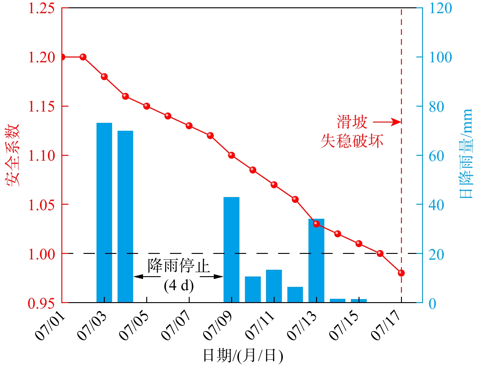


, Available online , doi: 10.19509j.cnki.dzkq.tb202605024
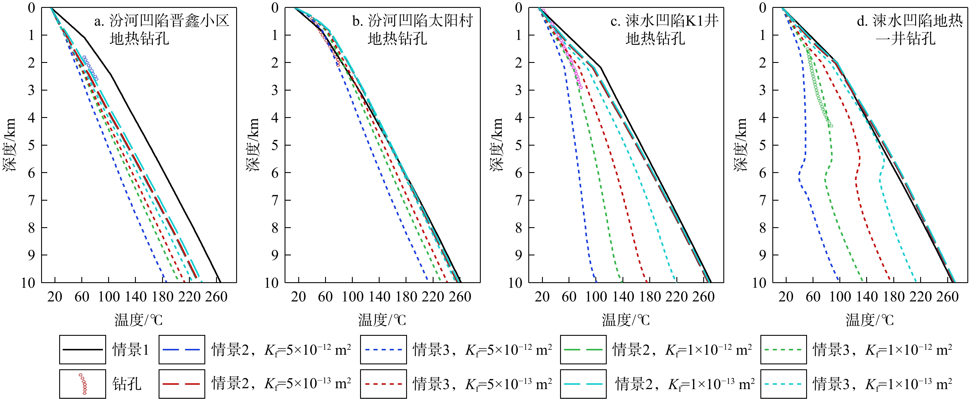
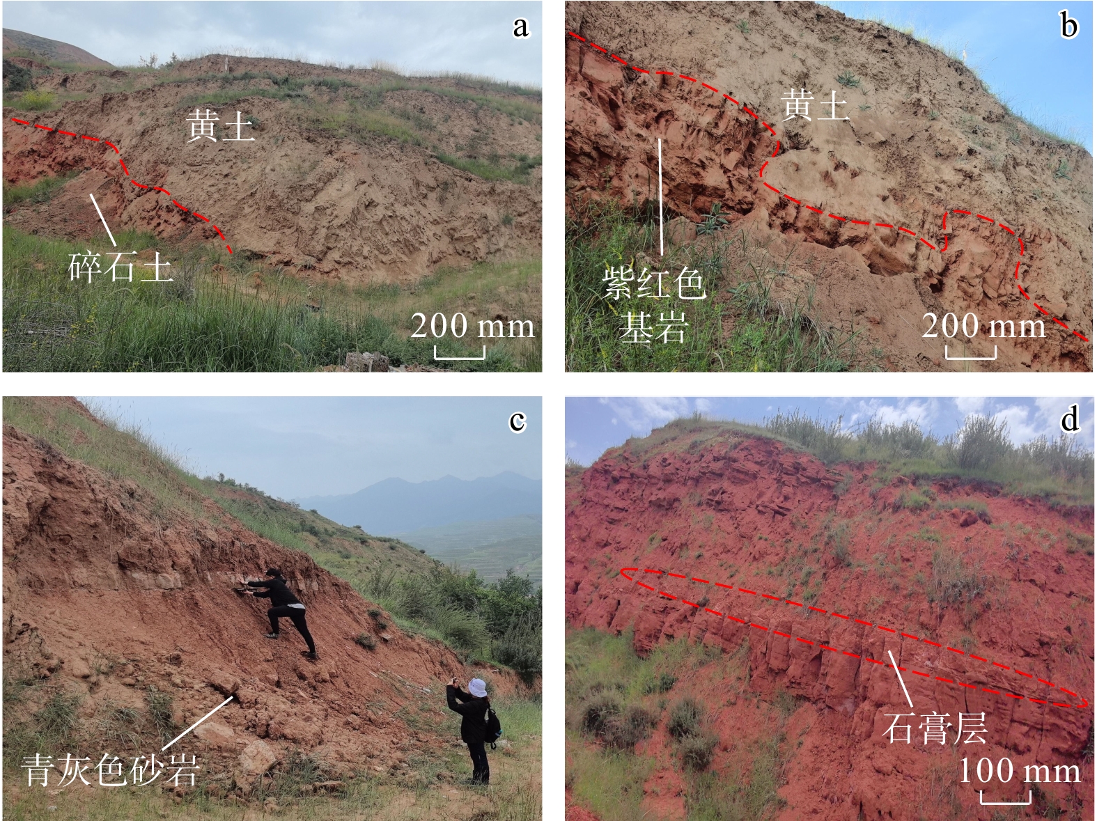
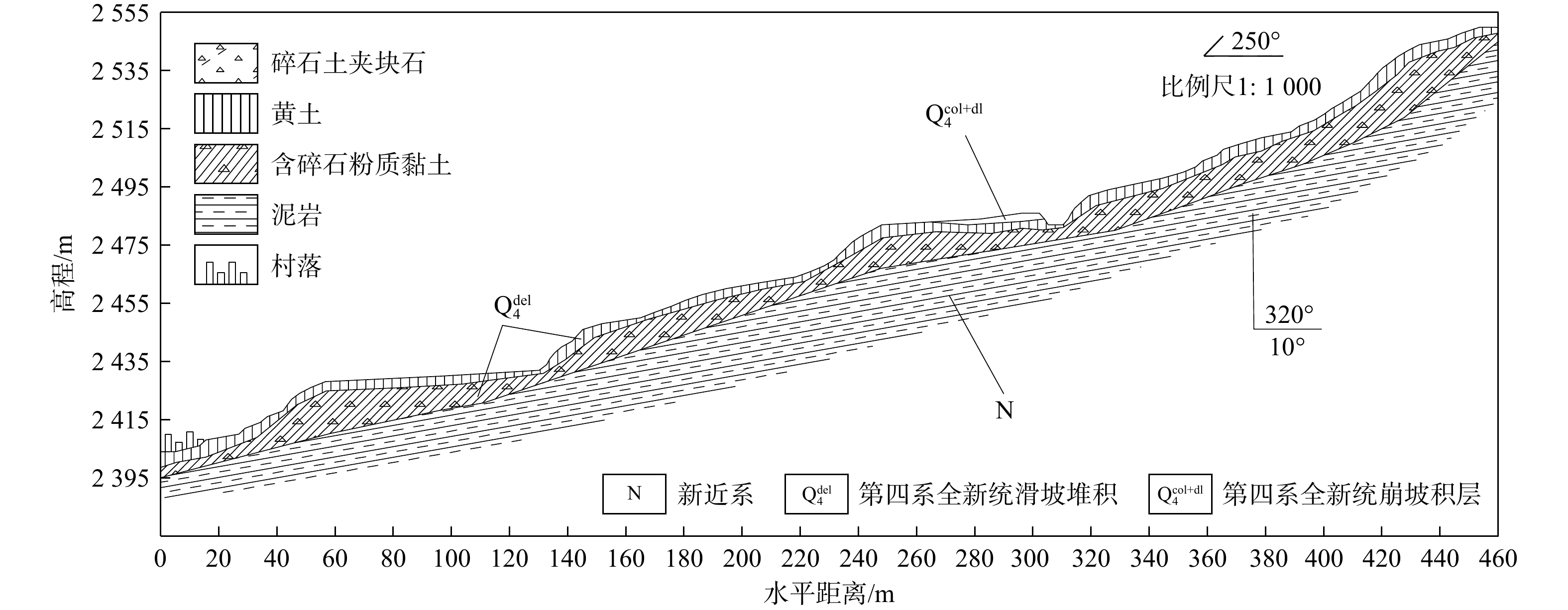
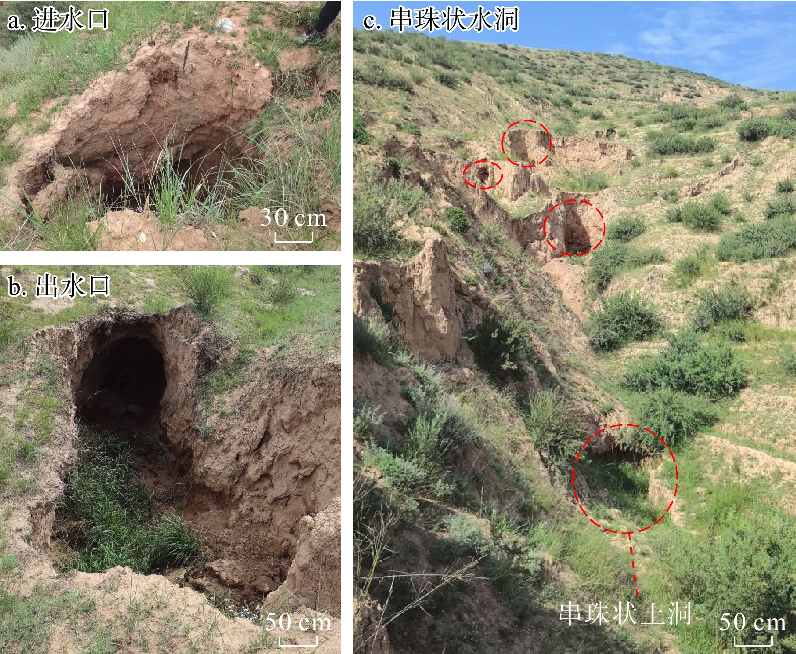
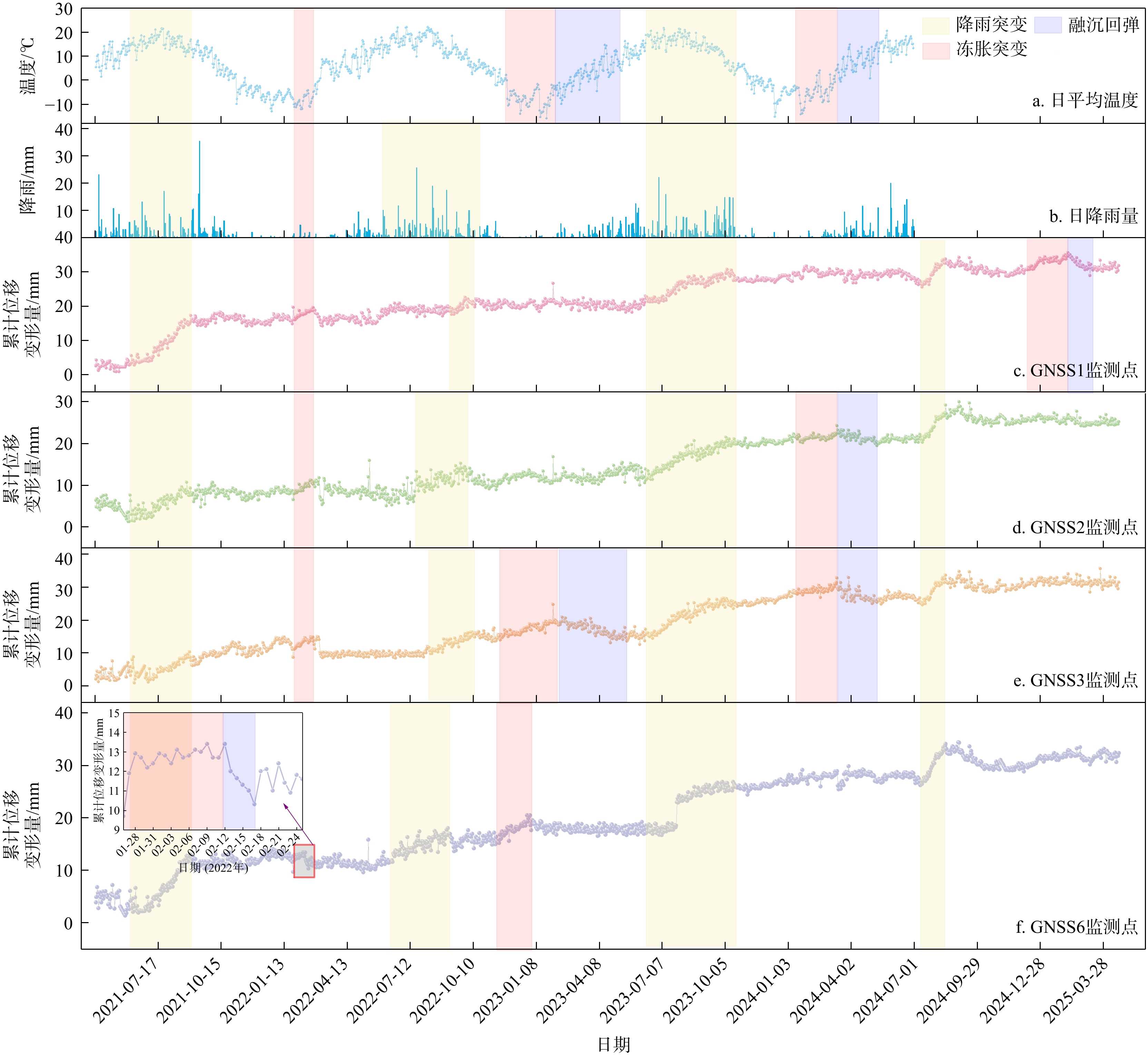
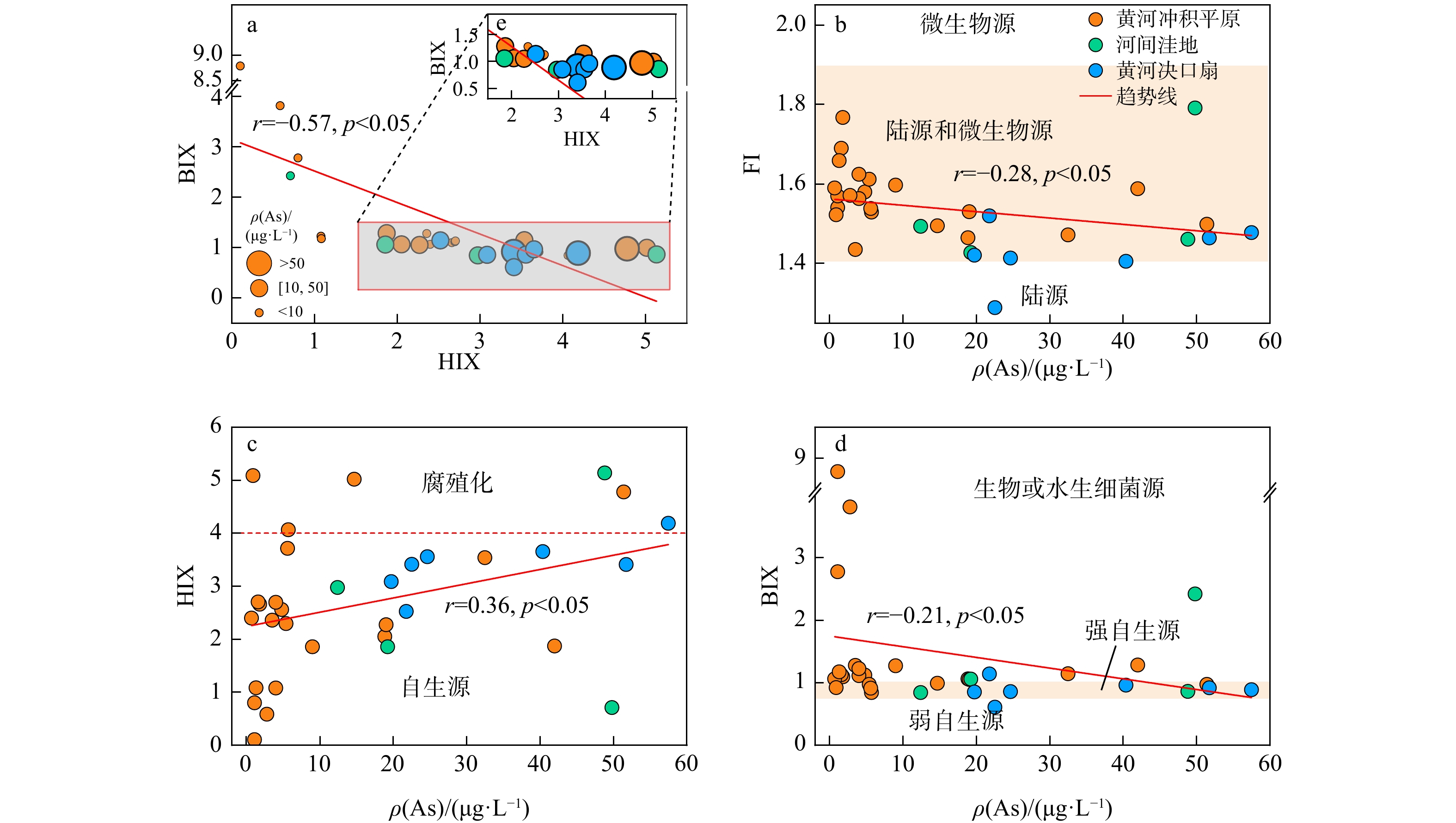
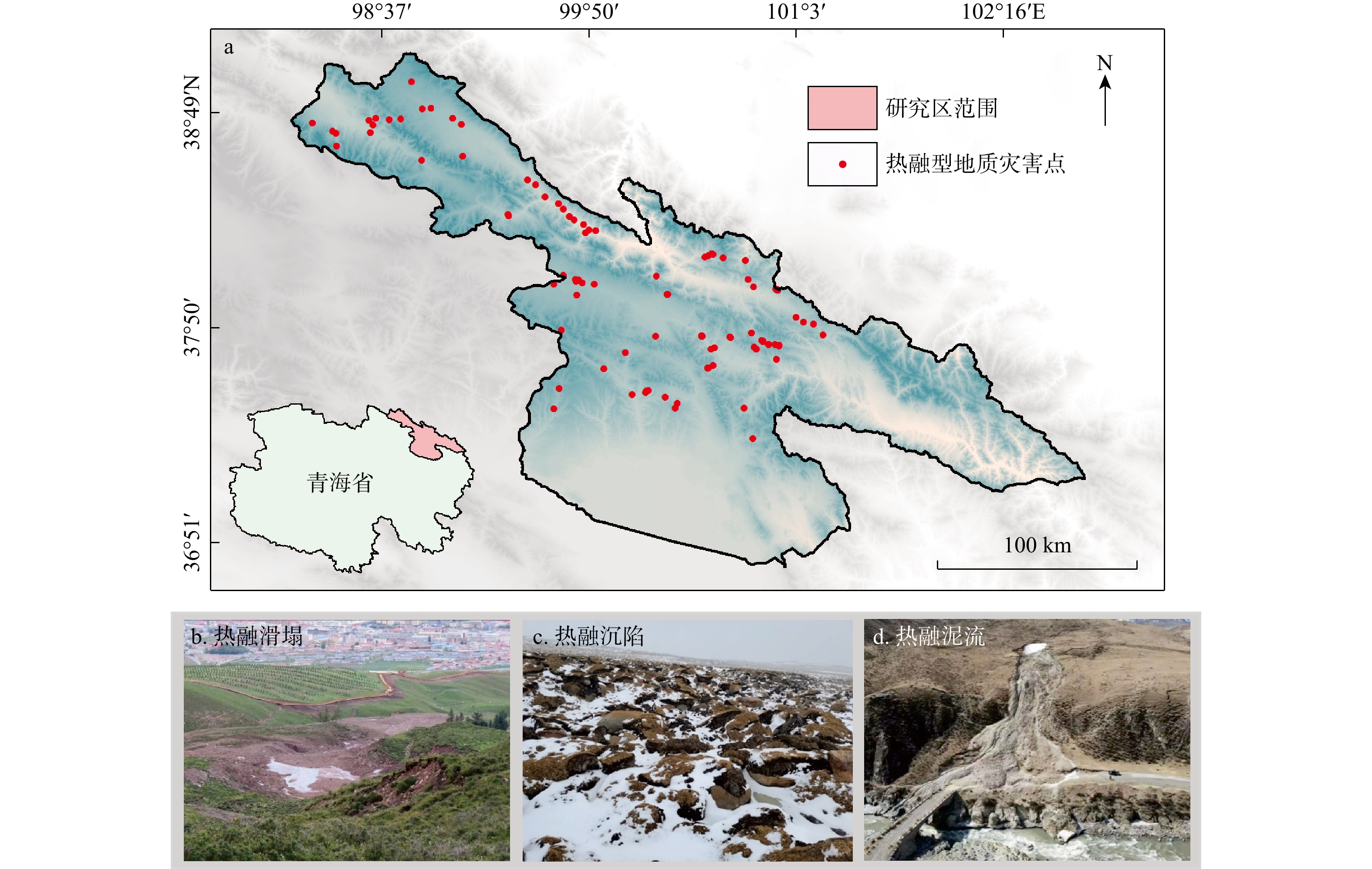
Abstract:
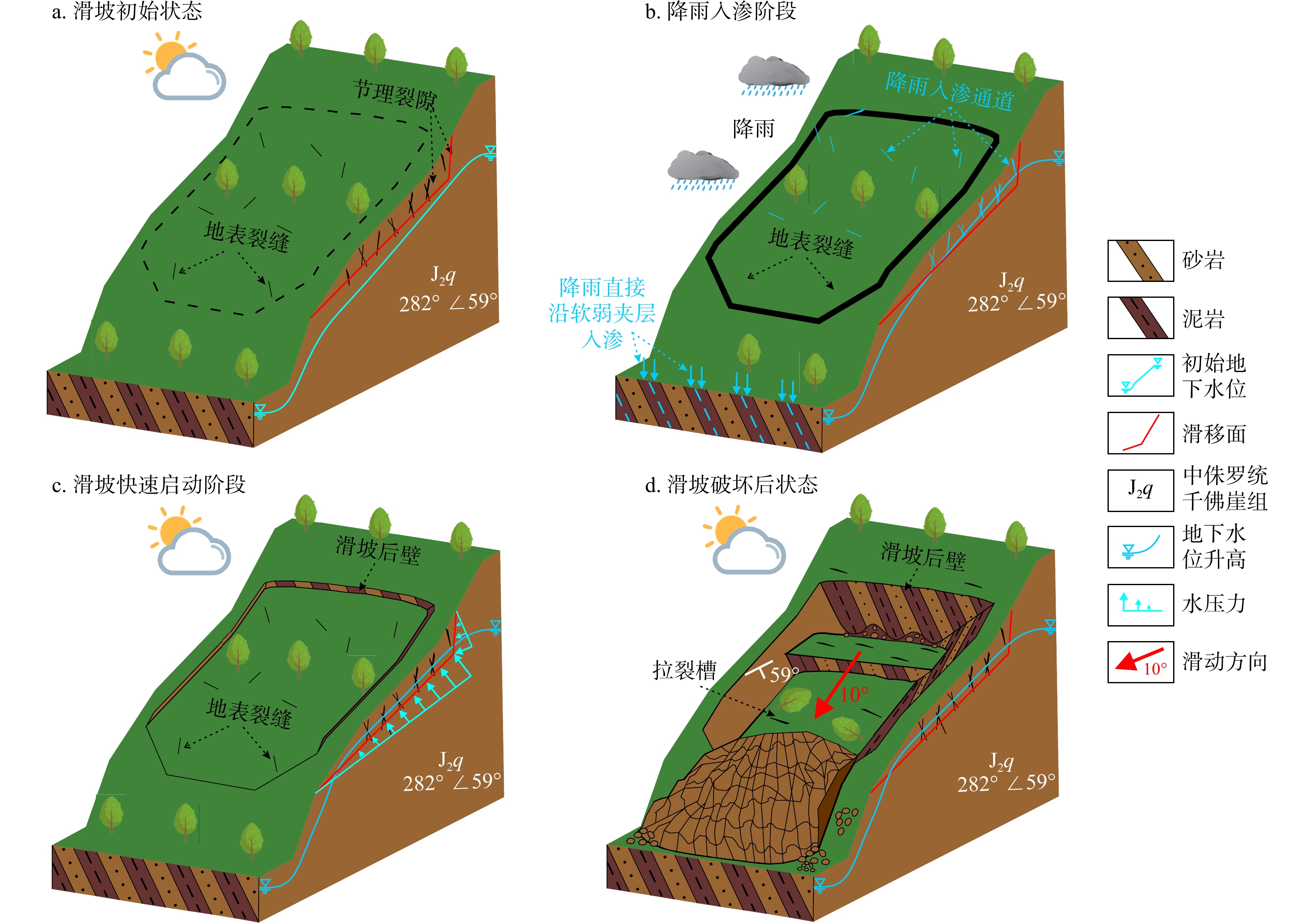
, Available online , doi: 10.19509j.cnki.dzkq.tb202604007
Abstract:
, Available online , doi: 10.19509j.cnki.dzkq.tb202605031
Abstract:

, Available online , doi: 10.19509j.cnki.dzkq.tb202604038
Abstract:


, Available online , doi: 10.19509j.cnki.dzkq.tb202602018
Abstract:
, Available online , doi: 10.19509j.cnki.dzkq.tb202603044
Abstract:
, Available online , doi: 10.19509j.cnki.dzkq.tb202605052
Abstract:
, Available online , doi: 10.19509j.cnki.dzkq.tb202604050
Abstract:
, Available online , doi: 10.19509j.cnki.dzkq.tb202602026
Abstract:
, Available online , doi: 10.19509/j.cnki.dzkq.tb20250553
Abstract:
, Available online , doi: 10.19509j.cnki.dzkq.tb202603014
Abstract:
, Available online , doi: 10.19509j.cnki.dzkq.tb202603021
Abstract:
, Available online , doi: 10.19509j.cnki.dzkq.tb202602009
Abstract:


, Available online , doi: 10.19509j.cnki.dzkq.tb202603033
Abstract:
, Available online , doi: 10.19509j.cnki.dzkq.tb202601005
Abstract:
, Available online , doi: 10.19509j.cnki.dzkq.tb202603036
Abstract:
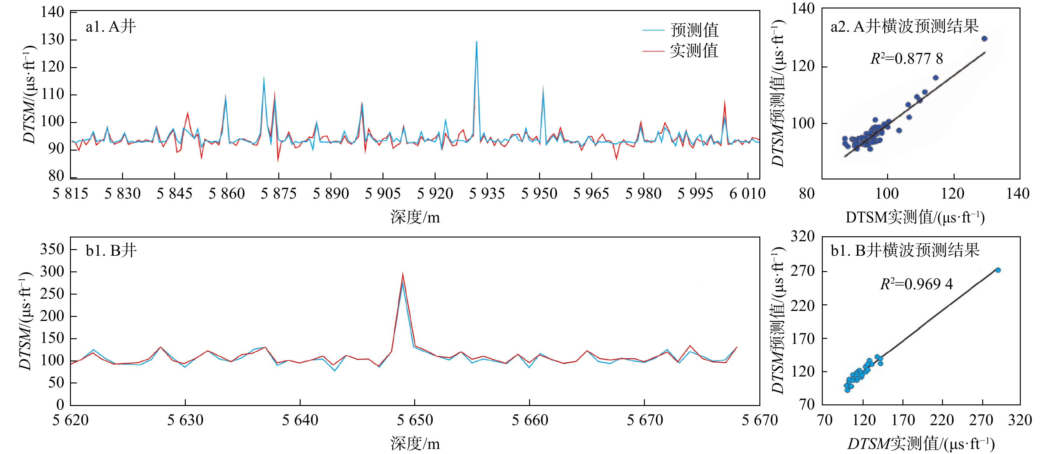
Automatic classification method of rock lithology based on ResNet network and deep transfer learning
, Available online , doi: 10.19509j.cnki.dzkq.tb202603053
Abstract:
, Available online , doi: 10.19509j.cnki.dzkq.tb202603004
Abstract:
, Available online , doi: 10.19509j.cnki.dzkq.tb202602003
Abstract:
, Available online , doi: 10.19509j.cnki.dzkq.tb202601046
Abstract:
, Available online , doi: 10.19509j.cnki.dzkq.tb202602002
Abstract:
, Available online , doi: 10.19509/j.cnki.dzkq.tb202601026
Abstract:
, Available online , doi: 10.19509/j.cnki.dzkq.tb202602022
Abstract:
, Available online , doi: 10.19509/j.cnki.dzkq.tb20250260
Abstract:
, Available online , doi: 10.19509/j.cnki.dzkq.tb20250463
Abstract:
, Available online , doi: 10.19509/j.cnki.dzkq.tb20250469
Abstract:
, Available online , doi: 10.19509/j.cnki.dzkq.tb20250485
Abstract:
, Available online , doi: 10.19509/j.cnki.dzkq.tb20250440
Abstract:
, Available online , doi: 10.19509/j.cnki.dzkq.tb20250516
Abstract:
, Available online , doi: 10.19509/j.cnki.dzkq.tb20250253
Abstract:
, Available online , doi: 10.19509/j.cnki.dzkq.tb20250304
Abstract:
, Available online , doi: 10.19509/j.cnki.dzkq.tb20250491
Abstract:
, Available online , doi: 10.19509/j.cnki.dzkq.tb20250541
Abstract:
, Available online , doi: 10.19509/j.cnki.dzkq.tb20250371
Abstract:
, Available online , doi: 10.19509/j.cnki.dzkq.tb20250471
Abstract:
, Available online , doi: 10.19509/j.cnki.dzkq.tb20250430
Abstract:
, Available online , doi: 10.19509/j.cnki.dzkq.tb20250480
Abstract:
, Available online , doi: 10.19509/j.cnki.dzkq.tb20250518
Abstract:
, Available online , doi: 10.19509/j.cnki.dzkq.tb20250447
Abstract:
, Available online , doi: 10.19509/j.cnki.dzkq.tb20250470
Abstract:
, Available online , doi: 10.19509/j.cnki.dzkq.tb20250389
Abstract:
, Available online , doi: 10.19509/j.cnki.dzkq.tb20250441
Abstract:
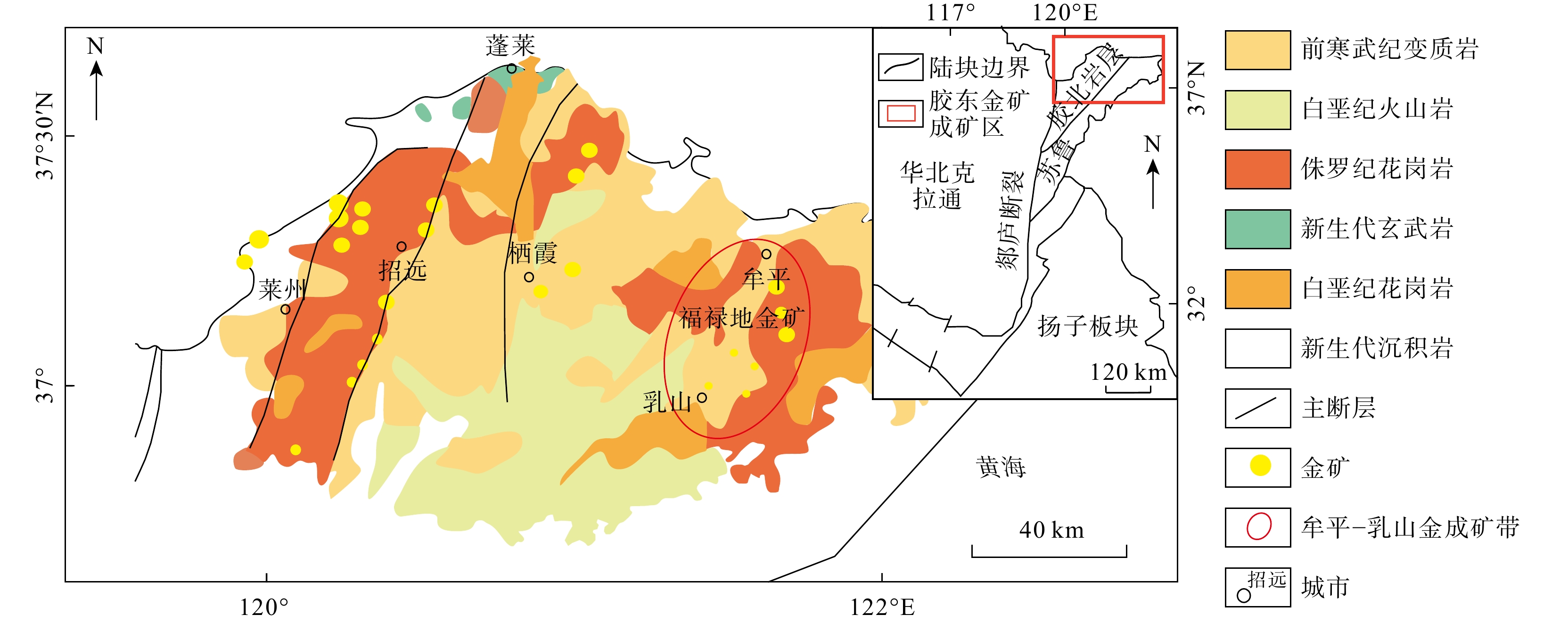
Vesicle-Filling Processes of Cretaceous Volcanic Rocks in the Honghaershute Depression, Erlian Basin
, Available online , doi: 10.19509/j.cnki.dzkq.tb20250392
Abstract:
, Available online , doi: 10.19509/j.cnki.dzkq.tb20250415
Abstract:
, Available online , doi: 10.19509/j.cnki.dzkq.tb20250327
Abstract:
, Available online , doi: 10.19509/j.cnki.dzkq.tb20250302
Abstract:
, Available online , doi: 10.19509/j.cnki.dzkq.tb20250319
Abstract:
, Available online , doi: 10.19509/j.cnki.dzkq.tb20250353
Abstract:
, Available online , doi: 10.19509/j.cnki.dzkq.tb20250398
Abstract:
, Available online , doi: 10.19509/j.cnki.dzkq.tb20250421
Abstract:
, Available online , doi: 10.19509/j.cnki.dzkq.tb20250434
Abstract:
, Available online , doi: 10.19509/j.cnki.dzkq.tb20250295
Abstract:
, Available online , doi: 10.19509/j.cnki.dzkq.tb20250169
Abstract:
, Available online , doi: 10.19509/j.cnki.dzkq.tb20250285
Abstract:
, Available online , doi: 10.19509/j.cnki.dzkq.tb20250391
Abstract:
, Available online , doi: 10.19509/j.cnki.dzkq.tb20250298
Abstract:

