| Citation: | HU Xiangxiang,SHI Yaya,AN Leping,et al. Driving mechanisms of land subsidence in Yellow River basin based on SBAS-InSAR monitoring combined with MGWR and Geodetector: A case study of Qinzhou District, Tianshui City, Gansu Province[J]. Bulletin of Geological Science and Technology,2026,45(3):86-102 doi: 10.19509/j.cnki.dzkq.tb20250192

|
The Yellow River basin is a critical ecological barrier and a strategic area for high-quality economic development in China. However, land subsidence issues are particularly pronounced in typical hilly-mountainous-urban transitional zones. Taking the Qinzhou District, Tianshui City, Gansu Province, an important urban node in the upper Yellow River basin, as the study area, this study aims to analyze the spatial heterogeneity characteristics and multi-factor synergistic driving mechanisms of land subsidence.
Based on 50 Sentinel-1A synthetic aperture radar (SAR) images acquired between June 2021 and June 2024, the small baseline subset interferometric synthetic aperture radar (SBAS-InSAR) technique was employed to monitor land subsidence dynamics. Multiscale geographically weighted regression (MGWR) was then applied to quantitatively explore the spatial heterogeneity of multiple influencing factors. Additionally, the Geodetector model was used to analyze the interaction effects among key factors to comprehensively identify their synergistic impacts on land subsidence.
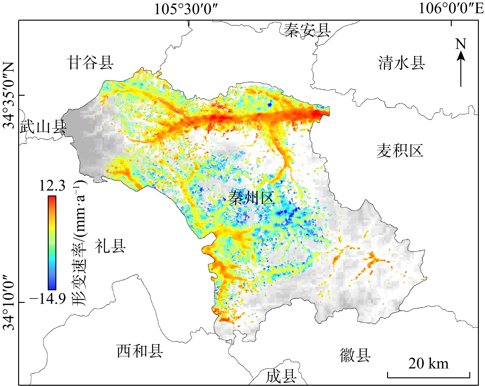
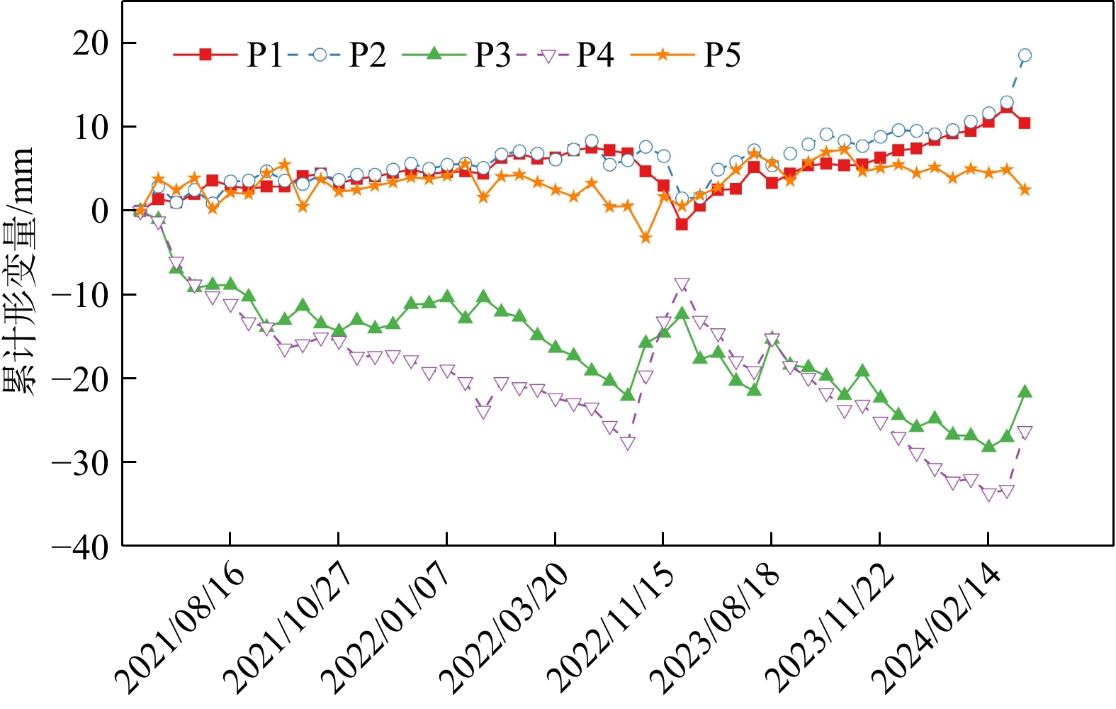
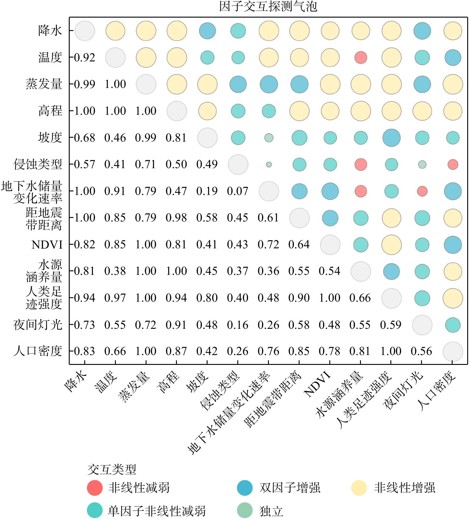
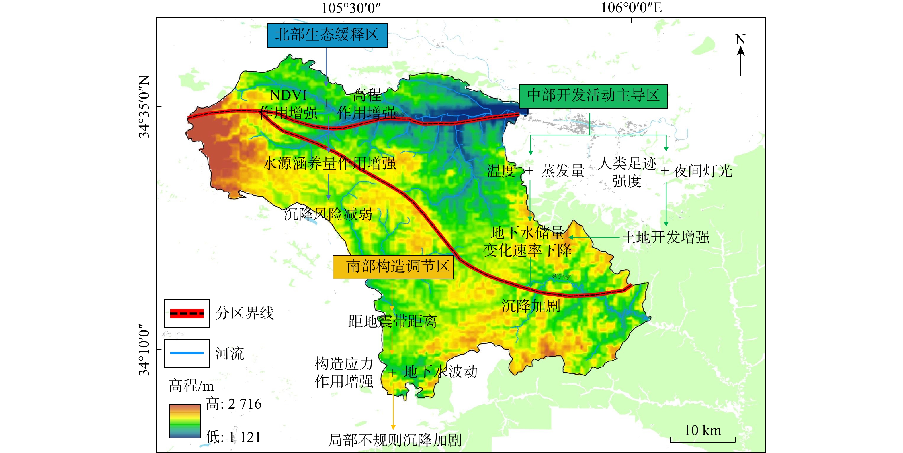
① Significant spatial heterogeneity in land subsidence was identified in Qinzhou District. The main subsidence areas were concentrated in the southeastern and southern urban zones, with a maximum average annual deformation rate of −14.9 mm/a and a maximum cumulative displacement of −76.91 mm. In contrast, the main urban area exhibited an overall uplift trend, with a maximum annual average uplift rate of 12.3 mm/a and a maximum cumulative uplift of 36.81 mm. ② The MGWR model revealed that human activity-related factors, including human footprint intensity and nighttime light, played significant roles in urban subsidence areas. Factors such as elevation and precipitation generally exhibited negative effects, whereas the normalized difference vegetation index (NDVI) and water conservation capacity showed pronounced spatial heterogeneity. Moreover, the groundwater storage change rate was more strongly associated with land subsidence in the western and southwestern parts of the study area. ③ Geodetector interaction analysis further revealed strong nonlinear interactive enhancement effects among key factor combinations, including temperature and groundwater storage change rate, human footprint intensity and evapotranspiration, and elevation and NDVI.
Land subsidence in Qinzhou District results from complex synergistic interactions of multiple natural and anthropogenic factors. This study enhances the understanding of land subsidence mechanisms in typical hilly-mountainous-urban transitional areas of the Yellow River basin and provides scientific evidence and practical guidance for regional ecological protection and high-quality sustainable development.

| [1] |
苗长虹, 夏成, 金凤君, 等. 黄河流域生态保护和高质量发展战略实施成效与推进策略[J]. 自然资源学报, 2025, 40(3): 569-583. doi: 10.31497/zrzyxb.20250301
MIAO C H, XIA C, JIN F J, et al. Implementation effectiveness and promotion strategies of ecological protection and high-quality development strategy in the Yellow River basin[J]. Journal of Natural Resources, 2025, 40(3): 569-583. (in Chinese with English abstract doi: 10.31497/zrzyxb.20250301
|
| [2] |
孙宝娣, 钟城豪, 崔东旭, 等. 区域协同视角下黄河流域生态安全格局构建[J]. 生态学报, 2024, 44(11): 4624-4636. doi: 10.20103/j.stxb.202307241578
SUN B D, ZHONG C H, CUI D X, et al. Constructing ecological security patterns through regional cooperation in the Yellow River basin[J]. Acta Ecologica Sinica, 2024, 44(11): 4624-4636. (in Chinese with English abstract doi: 10.20103/j.stxb.202307241578
|
| [3] |
任捷, 王迪, 王雅荣, 等. 黄河流域复合型灾害风险特征与演化模式研究[J]. 安全与环境学报, 2025, 25(3): 1078-1089. doi: 10.13637/j.issn.1009-6094.2024.1367
REN J, WANG D, WANG Y R, et al. Investigation of risk characteristics and evolution models for compound disasters in the Yellow River basin[J]. Journal of Safety and Environment, 2025, 25(3): 1078-1089. (in Chinese with English abstract doi: 10.13637/j.issn.1009-6094.2024.1367
|
| [4] |
田雨欣, 田美荣, 冯朝阳. 黄河流域生态安全评估与影响因素分析[J]. 人民黄河, 2024, 46(2): 107-111. doi: 10.3969/j.issn.1000-1379.2024.02.018
TIAN Y X, TIAN M R, FENG C Y. Ecological security assessment and influencing factors analysis of the Yellow River basin[J]. Yellow River, 2024, 46(2): 107-111. (in Chinese with English abstract doi: 10.3969/j.issn.1000-1379.2024.02.018
|
| [5] |
王浩杰, 孙萍, 张帅, 等. 天水市北山滑坡群发育特征及坡体结构分区[J]. 地质力学学报, 2023, 29(2): 236-252. doi: 10.12090/j.issn.1006-6616.2022052
WANG H J, SUN P, ZHANG S, et al. Characteristics and slope structure of the Beishan landslide group in Tianshui City[J]. Journal of Geomechanics, 2023, 29(2): 236-252. (in Chinese with English abstract doi: 10.12090/j.issn.1006-6616.2022052
|
| [6] |
朱荣, 敖泽建, 蒋友严. 基于CRITIC客观赋权法的天水市生态环境脆弱性评价[J]. 中国沙漠, 2024, 44(3): 321-331.
ZHU R, AO Z J, JIANG Y Y. Assessment of ecological environment vulnerability in Tianshui City based on the CRITIC objective weighting method[J]. Journal of Desert Research, 2024, 44(3): 321-331. (in Chinese with English abstract
|
| [7] |
严天笑, 张建通, 朱月琴, 等. 增量学习在滑坡易发性评价中的应用: 以甘肃省天水市为例[J]. 地质通报, 2024, 43(4): 630-640.
YAN T X, ZHANG J T, ZHU Y Q, et al. Application of incremental learning in landslide susceptibility assessment: A case study of Tianshui, Gansu Province[J]. Geological Bulletin of China, 2024, 43(4): 630-640. (in Chinese with English abstract
|
| [8] |
胡祥祥, 石亚亚, 胡良柏, 等. 融合InSAR与信息量-机器学习耦合模型的黄土滑坡易发性评价[J]. 西北地质, 2025, 58(2): 159-171. doi: 10.12401/j.nwg.2024112
HU X X, SHI Y Y, HU L B, et al. Evaluation of loess landslide susceptibility by combining in SAR and information-machine learning coupling model[J]. Northwestern Geology, 2025, 58(2): 159-171. (in Chinese with English abstract doi: 10.12401/j.nwg.2024112
|
| [9] |
柯福阳, 胡祥祥, 明璐璐, 等. 面向地表形变高精度监测的GNSS-InSAR融合方法[J]. 遥感技术与应用, 2023, 38(5): 1028-1041. doi: 10.11873/j.issn.1004-0323.2023.5.1028
KE F Y, HU X X, MING L L, et al. GNSS-INSAR fusion method for high precision monitoring of surface deformation[J]. Remote Sensing Technology and Application, 2023, 38(5): 1028-1041. (in Chinese with English abstract doi: 10.11873/j.issn.1004-0323.2023.5.1028
|
| [10] |
罗袆沅, 许强, 蒋亚楠, 等. 基于时序InSAR与机器学习的大范围地面沉降预测方法[J]. 地球科学, 2024, 49(5): 1736-1745. doi: 10.3799/dqkx.2023.048
LUO H Y, XU Q, JIANG Y N, et al. The prediction method of large-scale land subsidence based on multi-temporal InSAR and machine learning[J]. Earth Science, 2024, 49(5): 1736-1745. (in Chinese with English abstract doi: 10.3799/dqkx.2023.048
|
| [11] |
张子彦, 张敬凯, 张豪磊, 等. 南水北调中线焦作采空区地表沉降DS-InSAR监测与风险分析[J]. 遥感学报, 2024, 28(4): 900-910. doi: 10.11834/jrs.20242229
ZHANG Z Y, ZHANG J K, ZHANG H L, et al. Monitoring and risk analysis of surface subsidence in the Jiaozuo goaf along the middle route of the South-to-North Water Diversion Project based on the DS-InSAR method[J]. National Remote Sensing Bulletin, 2024, 28(4): 900-910. (in Chinese with English abstract doi: 10.11834/jrs.20242229
|
| [12] |
刘艺梁, 樊西丰, 申高伟, 等. 基于时序InSAR技术的木鱼包滑坡时空变形特征分析[J]. 地质科技通报, 2025, 44(2): 78-93. doi: 10.19509/j.cnki.dzkq.tb20240489
LIU Y L, FAN X F, SHEN G W, et al. Analysis of spatio-temporal deformation characteristics of the Muyubao landslide via time series InSAR technology[J]. Bulletin of Geological Science and Technology, 2025, 44(2): 78-93. (in Chinese with English abstract doi: 10.19509/j.cnki.dzkq.tb20240489
|
| [13] |
陈宝林, 李为乐, 陆会燕, 等. 基于SBAS-InSAR的黄河干流军功古滑坡形变分析[J]. 武汉大学学报(信息科学版), 2024, 49(8): 1407-1421.
CHEN B L, LI W L, LU H Y, et al. Deformation analysis of Jungong ancient landslide based on SBAS-InSAR technology in the Yellow River mainstream[J]. Geomatics and Information Science of Wuhan University, 2024, 49(8): 1407-1421. (in Chinese with English abstract
|
| [14] |
LI S W, XU W B, LI Z W. Review of the SBAS InSAR Time-series algorithms, applications, and challenges[J]. Geodesy and Geodynamics, 2022, 13(2): 114-126. doi: 10.1016/j.geog.2021.09.007
|
| [15] |
左世诚, 董杰, 廖明生. 时序InSAR形变梯度估计与城市建筑物风险评估: 以北京平原为例[J]. 地质科技通报, 2024, 43(6): 171-183.
ZUO S C, DONG J, LIAO M S. Time-series InSAR deformation gradient estimation and urban buildings risk assessment: A case study in the Beijing Plain[J]. Bulletin of Geological Science and Technology, 2024, 43(6): 171-183. (in Chinese with English abstract
|
| [16] |
胡祥祥, 柯福阳, 张志山, 等. 顾及多动态环境因子的滑坡演化规律研究: 以西宁市9大滑坡区为例[J]. 测绘通报, 2023(5): 21-26.
HU X X, KE F Y, ZHANG Z S, et al. Research on the evolution law of landslides considering multiple dynamic environmental factors: A case study of 9 major landslide areas in Xining City[J]. Bulletin of Surveying and Mapping, 2023(5): 21-26 (in Chinese with English abstract
|
| [17] |
何清, 魏路, 肖永红. 基于SBAS-InSAR技术的安徽亳州市地面沉降时空分布特征与影响因素分析[J]. 中国地质灾害与防治学报, 2023, 34(5): 81-90. doi: 10.16031/j.cnki.issn.1003-8035.202304004
HE Q, WEI L, XIAO Y H. Analysis of spatial-temporal distribution characteristics and influencing factors of land subsidence in Bozhou City, Anhui Province based on SBAS-InSAR technology[J]. The Chinese Journal of Geological Hazard and Control, 2023, 34(5): 81-90. (in Chinese with English abstract doi: 10.16031/j.cnki.issn.1003-8035.202304004
|
| [18] |
战卫彤, 吴一帆, 郑伟伟, 等. 黄河流域多时空土地利用/景观格局变化对水质的影响: 基于地理加权回归模型的实证[J]. 环境科学, 2025, 46(10): 6233-6243. doi: 10.13227/j.hjkx.202409146
ZHAN W T, WU Y F, ZHENG W W, et al. Impacts of changes of multi-temporal land use/landscape patterns on water quality in the Yellow River basin: An empirical study based on geographically weighted regression modeling[J]. Environmental science, 2025, 46(10): 6233-6243. (in Chinese with English abstract doi: 10.13227/j.hjkx.202409146
|
| [19] |
屈鹏鑫, 谢婉丽, 刘琦琦, 等. 基于机器学习方法改进IVM-RF耦合模型的崩滑灾害危险性评价: 以延安市志丹县为例[J]. 地质科技通报, 2025, 44(3): 280-295. doi: 10.19509/j.cnki.dzkq.tb20240583
QU P X, XIE W L, LIU Q Q, et al. Collapse and landslide risk assessment based on machine learning improved IVM-RF coupling method: A case study of Zhidan County, Yan'an City[J]. Bulletin of Geological Science and Technology, 2025, 44(3): 280-295. (in Chinese with English abstract doi: 10.19509/j.cnki.dzkq.tb20240583
|
| [20] |
王琰, 吕航, 谷复光. 多元线性回归方法在地面沉降量预测中的解析及应用[J]. 安全与环境工程, 2021, 28(3): 156-161. doi: 10.13578/j.cnki.issn.1671-1556.20201148
WANG Y, LYU H, GU F G. Analysis and application of multiple linear regression method in prediction of land subsidence[J]. Safety and Environmental Engineering, 2021, 28(3): 156-161. (in Chinese with English abstract doi: 10.13578/j.cnki.issn.1671-1556.20201148
|
| [21] |
张双成, 李民, 刘忠, 等. 时序InSAR解译西安−咸阳地区地面沉降时空分布特征[J]. 大地测量与地球动力学, 2024, 44(4): 391-397.
ZHANG S C, LI M, LIU Z, et al. Temporal and spatial distribution characteristics of land subsidence in Xi'an-Xianyang interpreted by time-series InSAR[J]. Journal of Geodesy and Geodynamics, 2024, 44(4): 391-397. (in Chinese with English abstract
|
| [22] |
李蓉蓉, 杨维芳, 李得宴. SBAS-InSAR和SDE在兰州市城区地面沉降监测中的应用[J]. 兰州交通大学学报, 2021, 40(2): 29-37. doi: 10.3969/j.issn.1001-4373.2021.02.005
LI R R, YANG W F, LI D Y. Application of SBAS-InSAR and SDE in land subsidence monitoring in the urban area of Lanzhou[J]. Journal of Lanzhou Jiaotong University, 2021, 40(2): 29-37. (in Chinese with English abstract doi: 10.3969/j.issn.1001-4373.2021.02.005
|
| [23] |
ZHANG J L, YANG R, QI Y, et al. A study on the monitoring of landslide deformation disasters in Wenxian County, Longnan City based on different time-series InSAR techniques[J]. Natural Hazards, 2024, 120(13): 11851-11875. doi: 10.1007/s11069-024-06663-5
|
| [24] |
曾学宏, 赵义花. 利用SBAS-InSAR技术分析西宁市地面沉降监测及驱动因素[J]. 测绘通报, 2022(6): 137-142. doi: 10.13474/j.cnki.11-2246.2022.0186
ZENG X H, ZHAO Y H. Analysis of land subsidence monitoring and driving factors in Xining City using SBAS-InSAR technology[J]. Bulletin of Surveying and Mapping, 2022(6): 137-142. (in Chinese with English abstract doi: 10.13474/j.cnki.11-2246.2022.0186
|
| [25] |
王守芬, 王守霞, 顾建祥. 基于多带宽局部多项式的时空地理加权分位数回归分析[J]. 地球信息科学学报, 2024, 26(3): 567-590.
WANG S F, WANG S X, GU J X. Geographically and temporally weighted quantile regression analysis based on multibandwidth local polynomial[J]. Journal of Geo-Information Science, 2024, 26(3): 567-590. (in Chinese with English abstract
|
| [26] |
刘宁, 邹滨, 张鸿辉. 地理加权回归建模结果不确定性度量与约束方法[J]. 测绘学报, 2023, 52(2): 307-317.
LIU N, ZOU B, ZHANG H H. Uncertainty measuring and constraining method for geographic weighted regression model results[J]. Acta Geodaetica et Cartographica Sinica, 2023, 52(2): 307-317. (in Chinese with English abstract
|
| [27] |
卢宾宾, 葛咏, 秦昆, 等. 地理加权回归分析技术综述[J]. 武汉大学学报(信息科学版), 2020, 45(9): 1356-1366. doi: 10.13203/j.whugis20190346
LU B B, GE Y, QIN K, et al. A review on geographically weighted regression[J]. Geomatics and Information Science of Wuhan University, 2020, 45(9): 1356-1366. (in Chinese with English abstract doi: 10.13203/j.whugis20190346
|
| [28] |
赵明松, 陈宣强, 徐少杰, 等. 基于MGWR的土壤pH值空间建模及其影响因素分析[J]. 环境科学, 2023, 44(12): 6909-6920. doi: 10.13227/j.hjkx.202212031
ZHAO M S, CHEN X Q, XU S J, et al. Spatial prediction modeling for soil pH based on multiscale geographical weighted regression (MGWR) and its influencing factors[J]. Environmental Science, 2023, 44(12): 6909-6920. (in Chinese with English abstract doi: 10.13227/j.hjkx.202212031
|
| [29] |
王钺, 周鹏辉, 潘海泽, 等. 路网形态与住宅价格的多尺度空间关系研究: 基于空间网络分析与多尺度地理加权回归模型[J]. 地理与地理信息科学, 2022, 38(1): 103-109.
WANG Y, ZHOU P H, PAN H Z, et al. A study on multi-scale spatial relationship between road network form and housing price based on sDNA and MGWR[J]. Geography and Geo-Information Science, 2022, 38(1): 103-109. (in Chinese with English abstract
|
| [30] |
KANG W, OSHAN T M. Scale and correlation in multiscale geographically weighted regression (MGWR)[J]. Journal of Geographical Systems, 2025, 27(3): 399-424. doi: 10.1007/s10109-025-00468-1
|
| [31] |
KUANG Y F, CHEN X L. Spatial heterogeneity of forest carbon stocks in the Xiangjiang River basin urban agglomeration: Analysis and assessment based on the multiscale geographically weighted regression (MGWR) model[J]. Frontiers in Environmental Science, 2025, 13: 1573438. doi: 10.3389/fenvs.2025.1573438
|
| [32] |
李泳君, 陈青长, 方贺, 等. 基于MGWR的长江流域植被演化及其影响因素[J]. 中国环境科学, 2024, 44(1): 352-362.
LI Y J, CHEN Q C, FANG H, et al. Vegetation evolution and its influencing factors in the Yangtze River basin based on multi-scale geographical weighted regression[J]. China Environmental Science, 2024, 44(1): 352-362. (in Chinese with English abstract
|
| [33] |
牛彦龙, 王毅. 基于MGWR模型的太行山区传统村落空间分异格局与影响机制研究[J]. 干旱区资源与环境, 2024, 38(9): 87-96.
NIU Y L, WANG Y. Spatial differentiation patterns of traditional villages in Taihang Mountain area and influencing mechanisms: A MGWR model based analysis[J]. Journal of Arid Land Resources and Environment, 2024, 38(9): 87-96. (in Chinese with English abstract
|
| [34] |
王楚, 丁瑞力, 陈蜜, 等. 京沪高速公路北京−天津段地面沉降时序InSAR监测与影响因素[J]. 地球科学与环境学报, 2024, 46(2): 269-284.
WANG C, DING R L, CHEN M, et al. Time series InSAR monitoring and influencing factors of land subsidence along the Beijing-Tianjin section of Beijing-Shanghai Expressway, China[J]. Journal of Earch Sciences and Environment, 2024, 46(2): 269-284. (in Chinese with English abstract
|
| [35] |
王翔宇, 张学霞, 胡韵哲, 等. 基于地理探测器的耕地土壤肥力及影响因子[J]. 环境科学, 2024, 45(12): 7378-7389.
WANG X Y, ZHANG X X, HU Y Z, et al. Soil fertility and influencing factors of cultivated land based on the geodetector[J]. Environmental Science, 2024, 45(12): 7378-7389. (in Chinese with English abstract
|
| [36] |
张任菲, 肖萌, 刘志成. 京津冀地区景观破碎化的时空异质性及驱动因素研究[J]. 生态环境学报, 2025, 34(3): 461-473. doi: 10.16258/j.cnki.1674-5906.2025.03.013
ZHANG R F, XIAO M, LIU Z C. Spatio-temporal heterogeneity and driving factors of landscape fragmentation in Beijing-Tianjin-Hebei region[J]. Ecology and Environmental Sciences, 2025, 34(3): 461-473. (in Chinese with English abstract doi: 10.16258/j.cnki.1674-5906.2025.03.013
|
| [37] |
覃星铭, 马国斌, 蒋忠诚, 等. 典型石漠化峰丛洼地土壤重金属的空间分异特征及其影响因素[J]. 地质科技通报, 2022, 41(5): 283-292. doi: 10.19509/j.cnki.dzkq.2022.0189
QIN X M, MA G B, JIANG Z C, et al. Spatial differentiation characteristics and influencing factors of heavy metals in soil of typical rocky desertification peak cluster depressions[J]. Bulletin of Geological Science and Technology, 2022, 41(5): 283-292. (in Chinese with English abstract doi: 10.19509/j.cnki.dzkq.2022.0189
|
| [38] |
王红玲, 胡祥祥, 石亚亚, 等. 基于SBAS-InSAR的秦州区大型滑坡监测[J]. 时空信息学报, 2025, 32(3): 276-287. doi: 10.20117/j.jsti.202503011
WANG H L, HU X X, SHI Y Y, et al. Large-scale landslide monitoring in Qinzhou District based on SBAS-InSAR[J]. Journal of Spatio-Temporal Information, 2025, 32(3): 276-287. (in Chinese with English abstract doi: 10.20117/j.jsti.202503011
|
| [39] |
贾静, 宿星, 张军, 等. 1985—2020年天水市黄土区滑坡灾损土地利用时空变化特征[J]. 水土保持学报, 2023, 37(4): 195-204. doi: 10.13870/j.cnki.stbcxb.2023.04.025
JIA J, SU X, ZHANG J, et al. Spatial and temporal variation characteristics of landslide disaster damage land use in loess area of Tianshui City from 1985 to 2020[J]. Journal of Soil and Water Conservation, 2023, 37(4): 195-204. (in Chinese with English abstract doi: 10.13870/j.cnki.stbcxb.2023.04.025
|
| [40] |
许泰, 鄂崇毅, 蒋兴波, 等. 天水市秦州区城区北山群发地质灾害发育现状及综合治理措施[J]. 科学技术与工程, 2021, 21(32): 13614-13627. doi: 10.3969/j.issn.1671-1815.2021.32.002
XU T, E C Y, JIANG X B, et al. Development status of mass geological disaster and comprehensive control measures in Beishan in Qinzhou District, Tianshui[J]. Science Technology and Engineering, 2021, 21(32): 13614-13627. (in Chinese with English abstract doi: 10.3969/j.issn.1671-1815.2021.32.002
|
| [41] |
FOTHERINGHAM S A, CRESPO R, YAO J. Geographical and temporal weighted regression (GTWR)[J]. Geographical Analysis, 2015, 47(4): 431-452. doi: 10.1111/gean.12071
|
Supported by:
Beijing Renhe Information Technology Co., Ltd.


 Submission System


 DownLoad: