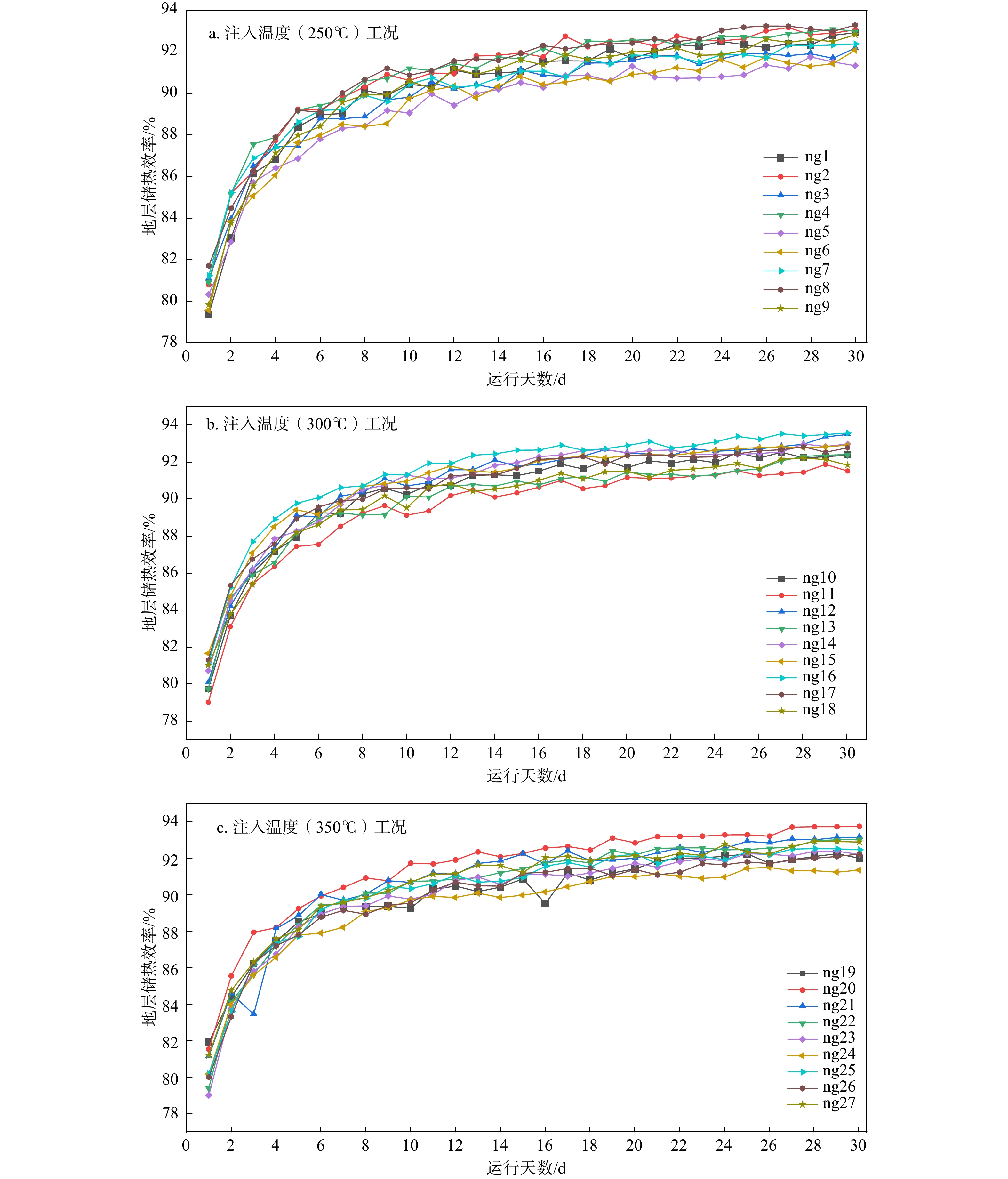
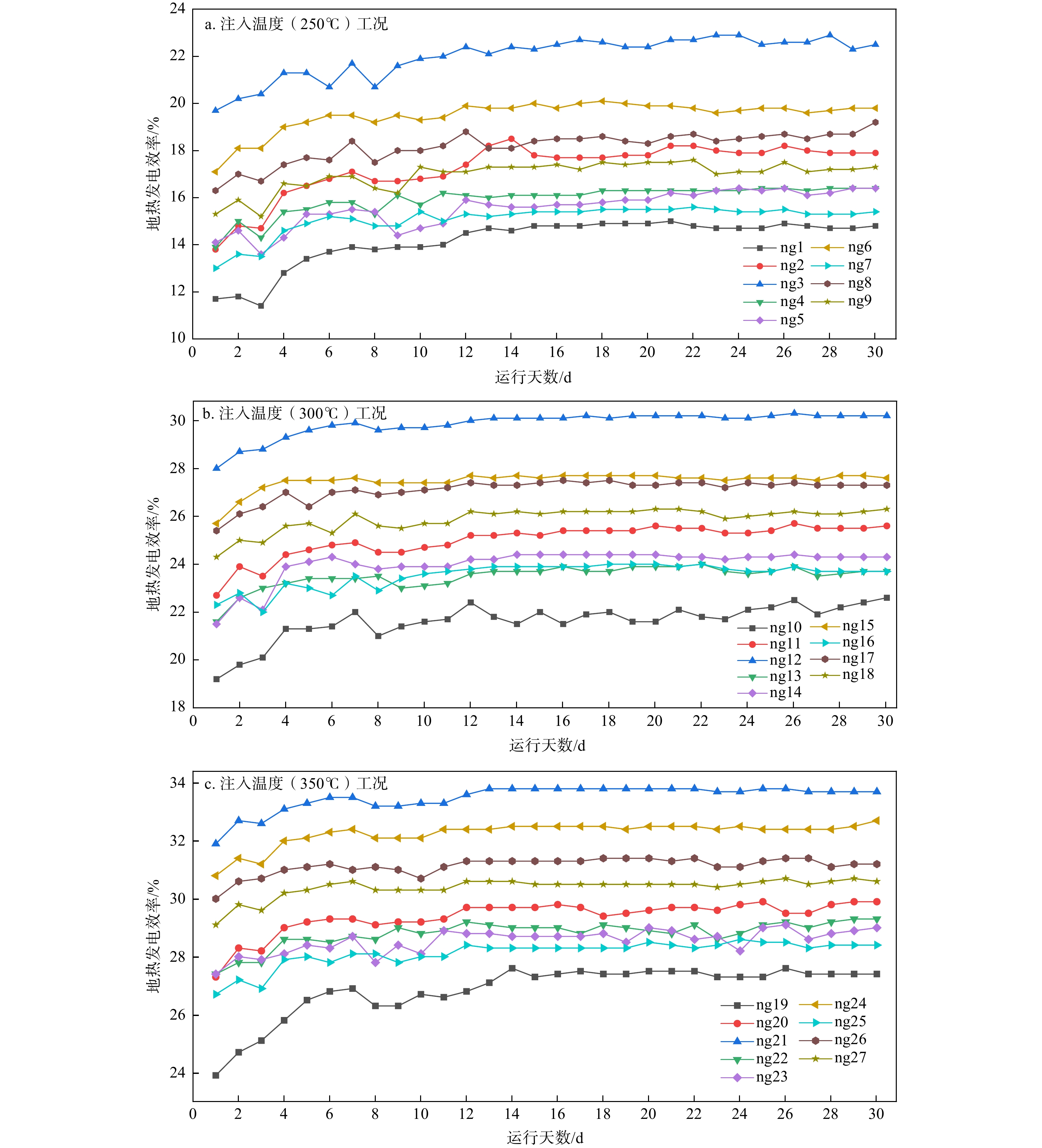
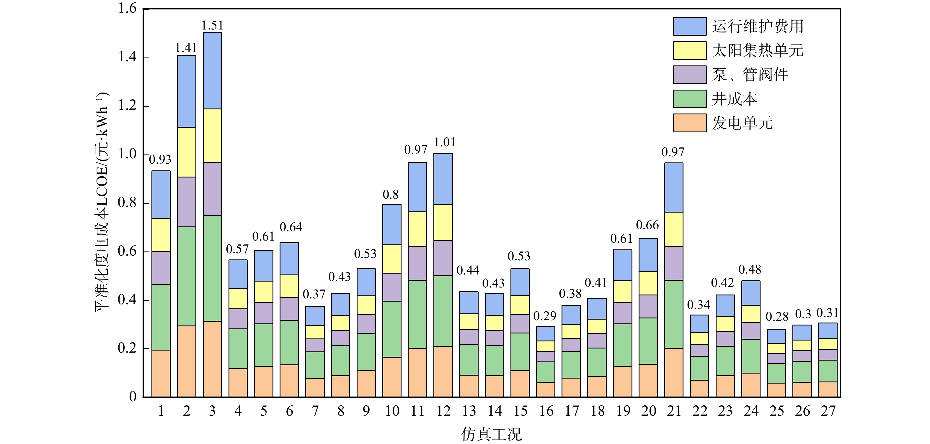
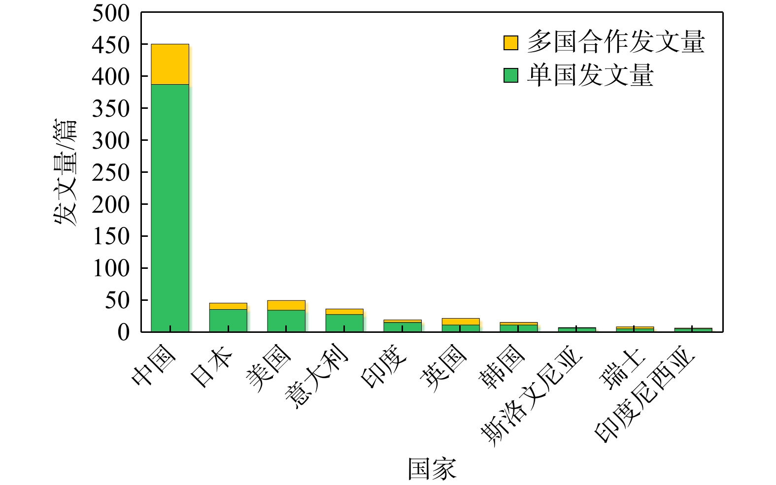
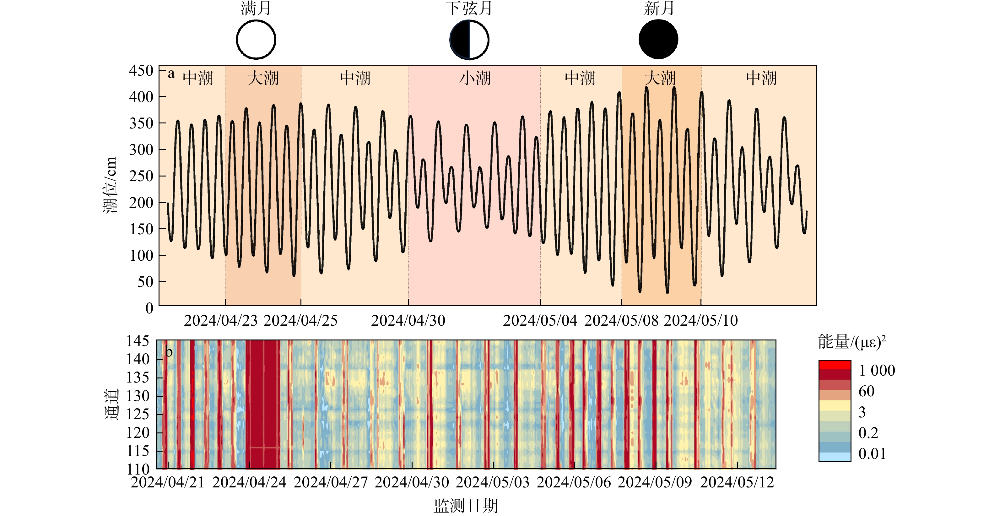
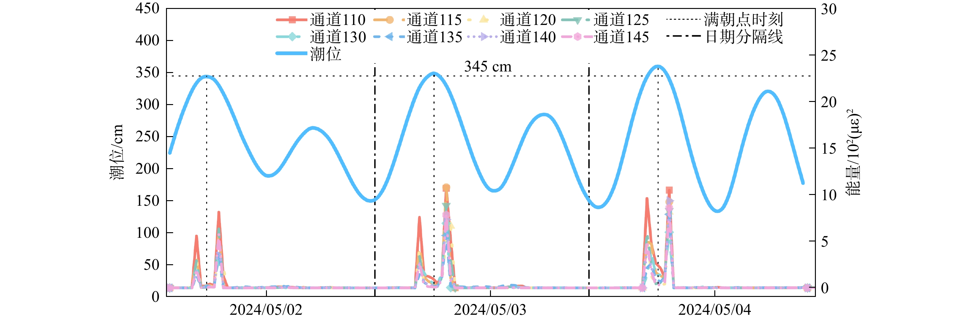
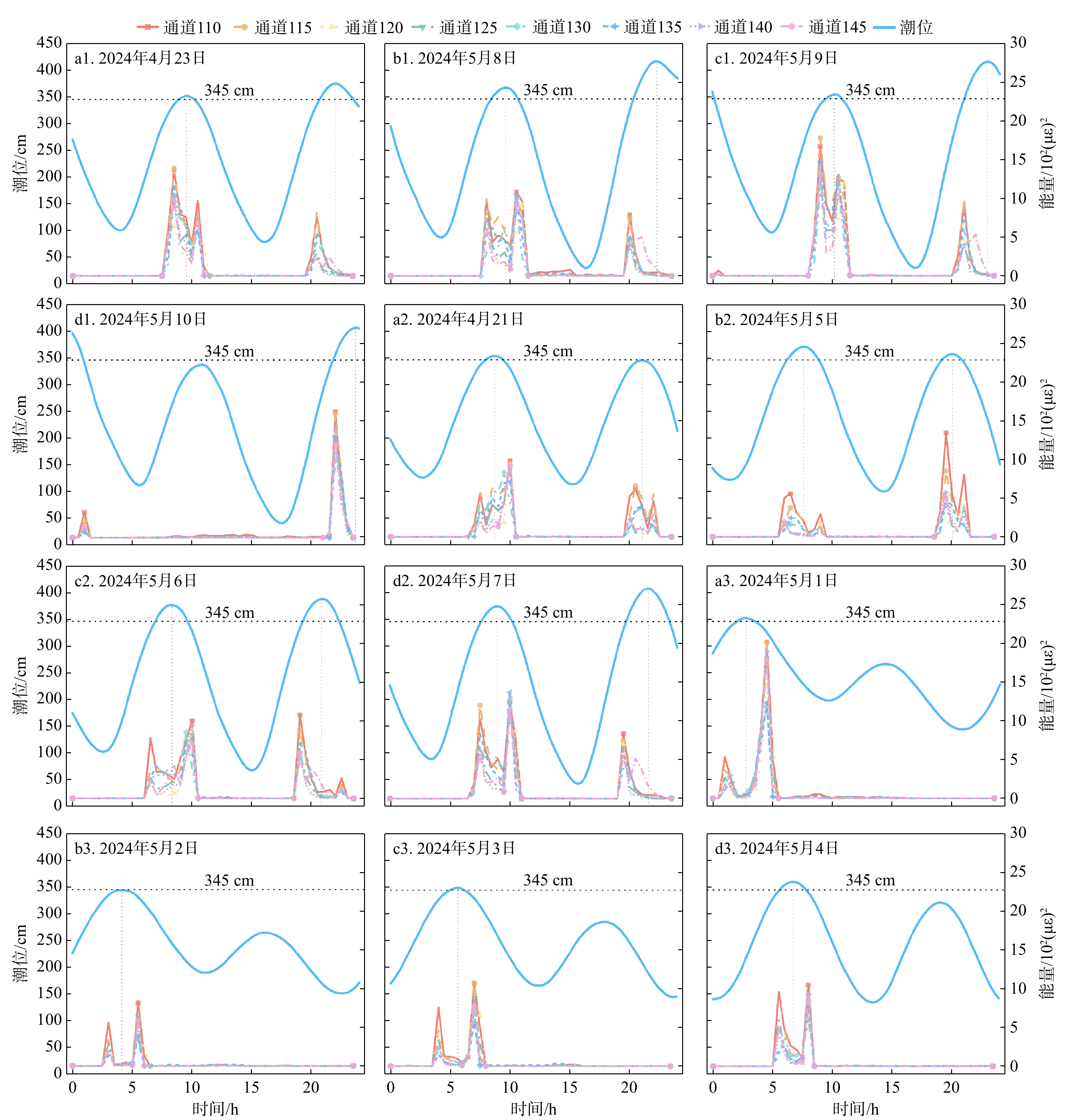
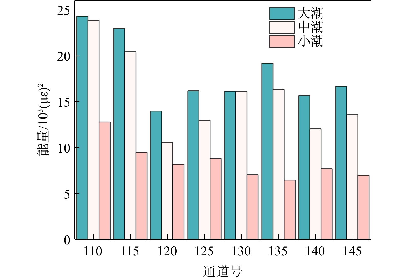
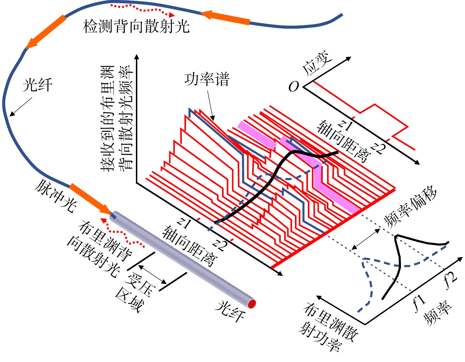
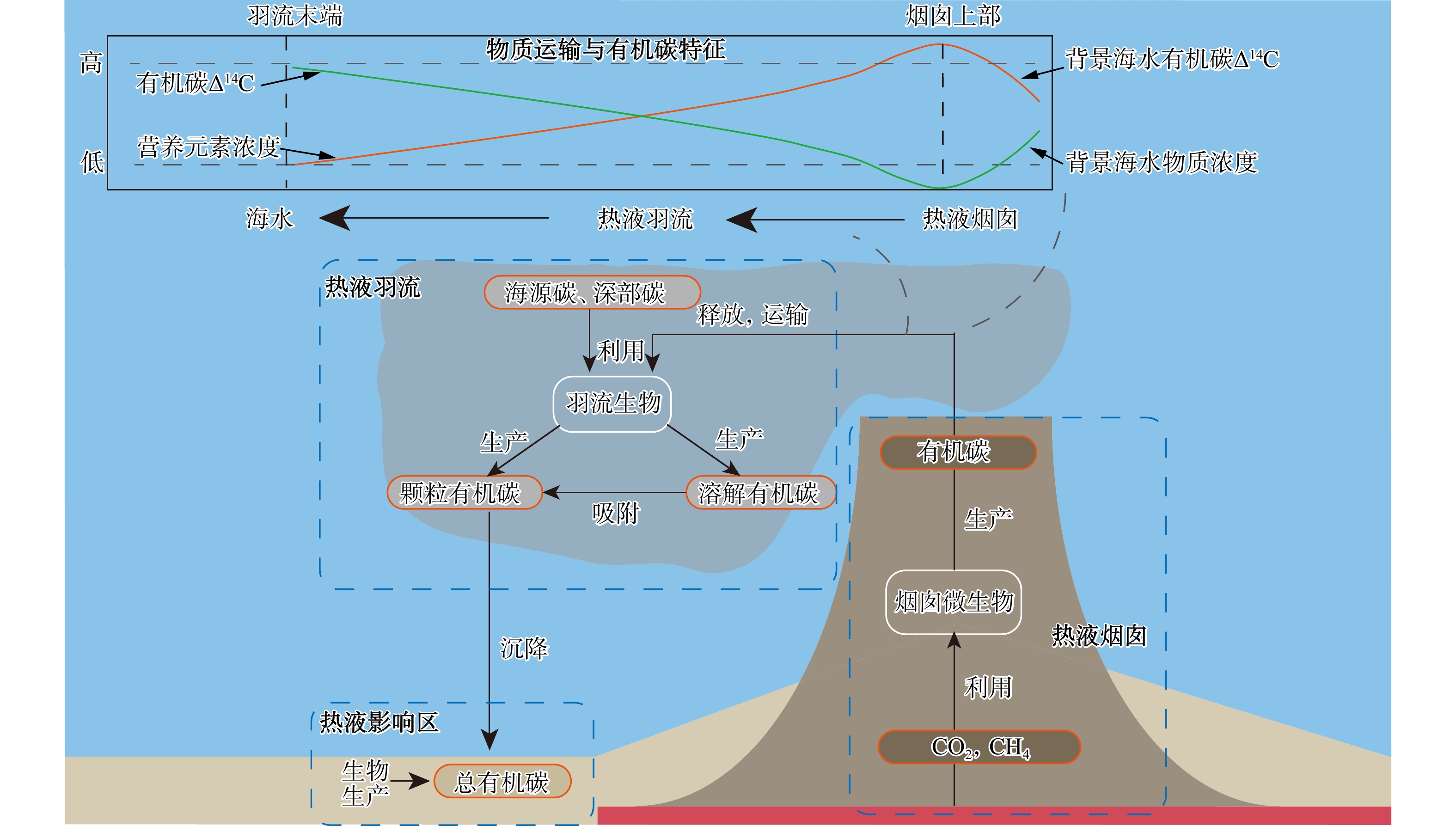
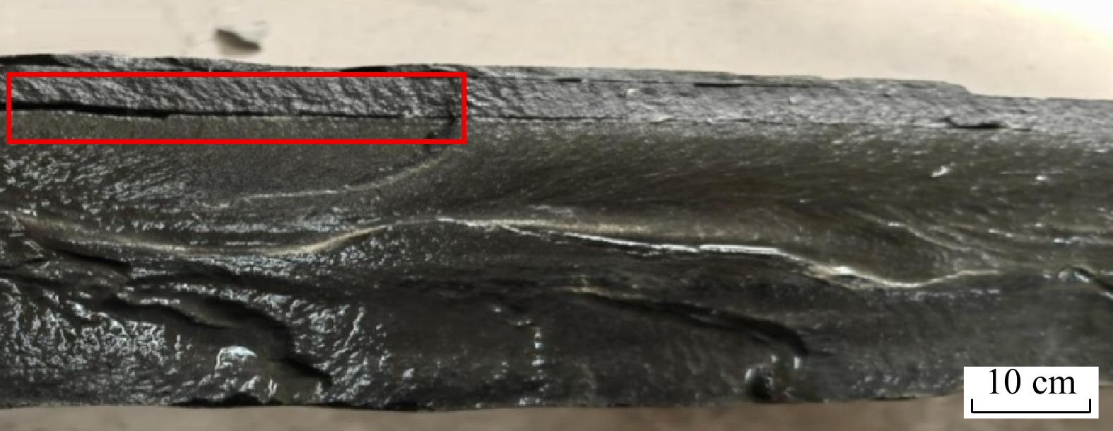
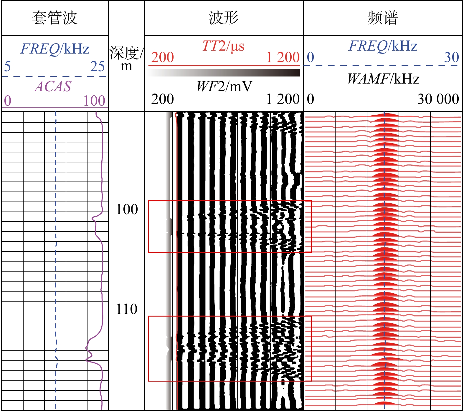
Current Issue

2026 Vol. 45, No. 3

Display Method:
Orthogonal experiment optimization and economic evaluation of multi-parameter coupled simulation of a concentrated solar power-geothermal energy storage system
WANG Yanxin, JIANG Shu, HU Fan, MA Chong, ZHOU Minmin, LI Man, HU Dawei, ZHANG Guohua, YE Cantao, GONG Yulie
2026, 45(3): 1-14. doi: 10.19509/j.cnki.dzkq.tb20250526
Abstract:
Objective

This study employs numerical simulation methods and orthogonal experimental design to conduct preliminary a priori research on a novel concentrated solar power-geothermal (GEO-CSP) long-duration energy storage system (LDES), aiming to comprehensively evaluate system parameter performance and economic feasibility. The new system utilizes concentrated solar power to heat a working fluid to high temperatures and injects the thermal energy into underground reservoirs via injection wells, thereby enhancing thermal storage capacity.

Methods

A multi-software coupled simulation approach was adopted. The SG-Tower software was used to calculate heliostat field heat collection performance via ray tracing. A COMSOL multiphysics model was used to simulate thermal-fluid coupled heat transfer in underground reservoirs, analyzing the effects of injection temperature, injection flow rate, and reservoir characteristics on thermal storage efficiency. A MATLAB/Simulink model was developed to simulate a two-stage flash power generation process.

Results

Based on the analysis of 27 sets of orthogonal experimental designs, the results indicated that under optimal operating conditions (e.g., injection temperature of 350 ℃ and injection flow rate of 100 m3/h), geothermal storage efficiency reached 93.6% and power generation efficiency reached 33.5%. Parameter sensitivity analysis revealed that injection temperature and injection flow rate were the primary controlling factors affecting system performance (with contribution rates of 78.3% and 14.0%, respectively). Under typical operating conditions, a reservoir thickness of approximately 100 meters balanced heat exchange efficiency and heat loss, achieving optimal overall system performance. Economic analysis indicated that in depleted oil and gas reservoir conversion scenarios, the investment payback period was reduced to less than 5 years, and the cumulative net profit of one well pair reached 31.5367 million yuan over a 30-year life cycle.

Conclusion

This priori study provides a theoretical basis for parameter optimization and engineering applications of solar-geothermal coupled energy storage and power generation systems, offers important insights for promoting the development of long-duration renewable energy storage technologies.

2026, 45(3): 15-16. doi: 10.19509/j.cnki.dzkq.tb20260003
Abstract:
Intelligent computing of rock mass rock quality designation based on deep learning and borehole image analysis
LI Dongli, LIU Xingyu, ZHANG Zhanrong, GE Yunfeng, LI Wei, ZHANG Zilong
2026, 45(3): 17-29. doi: 10.19509/j.cnki.dzkq.tb20250114
Abstract:
Purpose

Rock quality designation (RQD) is widely recognized as a fundamental index in geotechnical engineering for evaluating rock mass integrity. It is extensively applied in rock mass classification systems and serves as a key input parameter for engineering rating systems. Conventionally, RQD determination relies on manual logging of recovered drill cores. However, this approach is labor-intensive, time-consuming, and highly sensitive to drilling techniques and core quality, making it difficult to obtain objective and reliable RQD values.

Method

To address these challenges, this study proposed a novel, non-destructive approach based on the deep learning algorithm YOLOv5 (You Only Look Once, version 5) to detect and localize discontinuities directly from borehole televiewer images. It eliminated the disturbances and bias introduced during physical core extraction, enabling intelligent RQD computing. First, raw televiewer images were preprocessed, annotated, and augmented to build a representative dataset that highlighted natural fractures, bedding planes, and other geological discontinuities. Then, a YOLOv5 detector was trained on this dataset to recognize and segment discontinuities with high spatial accuracy. Finally, the model output was post-processed to compute RQD automatically by quantifying the proportion of intact rock segments exceeding the standard 10 cm threshold.

Results

To assess the method's performance, a case study was conducted on borehole zk04, part of a tunnel project in Yongzhou City, Hunan Province, China. Intelligent RQD values derived from the televiewer images were compared with conventional RQD measurements obtained from core boxes in the field. The results indicated that the automated approach tended to overestimate RQD by around 20% relative to manual measurements, with a mean absolute error of 9.82%. Despite this systematic bias, the spatial trend of RQD variation identified by the intelligent method closely matched that of in-situ wave velocity profiles, suggesting that the technique accurately captured relative changes in rock mass properties along the borehole.

Conclusion

Overall, the proposed YOLOv5-based workflow effectively reduces the influence of drilling-induced biases and core extraction artifacts on RQD estimation. By enabling rapid, repeatable, and objective computation of RQD directly from borehole images, the method enhances both efficiency and reliability of rock quality assessment. Future work will explore calibration strategies to correct systematic deviations and integrate complementary geophysical datasets. This approach demonstrates significant potential to digitalize geotechnical investigation processes, streamline tunnel engineering workflows, and advance rock mass characterization in a more robust and data-driven manner.

Simulation of disaster evolution process of Outang landslide in Three Gorges Reservoir area under extreme hydraulic conditions using material point method
ZHU Haonan, ZHU Honghu, XIE Tiancheng, YE Xiao, TAN Daoyuan, CHEN Guoqing
2026, 45(3): 30-42. doi: 10.19509/j.cnki.dzkq.tb20250204
Abstract:
Objective

Reservoir bank landslides are triggered by multiple factors, and their disaster evolution process and dynamic response characteristics exhibit significant nonlinearity and spatiotemporal heterogeneity. To achieve effective prevention and control of reservoir bank landslides, it is essential to elucidate the influence of the coupled action of rainfall infiltration and rapid reservoir water level drawdown under extreme conditions on the landslide evolution mechanisms and dynamic response patterns of landslides.

Methods

This study employed the material point method (MPM) to construct a two-dimensional numerical model of the Outang landslide in the Three Gorges Reservoir area, and simulated its initiation and acceleration processes under the combined action of rainfall and reservoir water level fluctuations. By analyzing the deformation and stability of different parts of the Outang landslide under different hydraulic conditions, this study revealed the evolutionary characteristics and instability mechanisms of the landslide.

Results

The results showed that: ① The stability of the Outang landslide was jointly controlled by rainfall and reservoir water level fluctuations. Reservoir water level drawdown mainly affected the primary sliding mass at the toe, while rainfall had the most significant impact on the stability of the tertiary sliding mass at the crest. This finding was highly consistent with monitoring data. ② Under the combined action of rainfall and water level fluctuations, localized collapse occurred at the toe and overall sliding occurred at the crest of the Outang landslide, and no obvious signs of instability were observed in the middle part. ③ Under extreme conditions of rapid water level drawdown and intense rainfall, significant sliding occurred only at the toe and crest, and the probability of overall sliding of the landslide mass along the bedrock interface was low. ④ During the failure initiation stage of the landslide mass, significant differences were observed between the distributions of initial strain and initial displacement along the main sliding direction, and this should be considered when arranging monitoring points.

Conclusion

Based on large-deformation numerical simulation, this study analyzes the main controlling factors of the long-term stability of giant paleo-landslides along reservoir banks, providing a theoretical basis for the early warning and prevention of such landslides.

Research progress and trend analysis of geological disaster chains based on bibliometrics
HE Xin, LI Shuai, WANG Jia, ZHU Honghu
2026, 45(3): 43-58. doi: 10.19509/j.cnki.dzkq.tb20250488
Abstract:
Significance

In the context of intensifying global climate change, the escalating threat posed by geological disaster chains has become increasingly severe. However, there remains a lack of a comprehensive and systematic quantitative review of the development of this research field. Therefore, a thorough synthesis of existing literature is imperative to elucidate the current state of knowledge and to clarify the research landscape surrounding these emerging and complex challenges under the new circumstances.

Progress

Utilizing bibliometric methodologies, this study analyzes 784 relevant publications indexed in the Web of Science core collection from 1989 to 2024. It constructs a four-dimensional analytical framework that systematically examines publication trends, collaborative networks among countries and institutions, the influence of academic journals, and the evolution of research themes.

Conclusions and Prospects

The principal findings are summarized as follows. ① The evolution of research exhibits a distinct three-phase trajectory: an initial phase (1989–2000), a development phase (2001–2012), and a rapid growth phase (2013–2024). This progression is driven by a combination of technology empowerment and case-based validation. Major disaster events provide critical empirical scenarios, while breakthroughs in observational and predictive technologies, such as light detection and ranging (LiDAR), interferometric synthetic aperture radar (InSAR), and artificial intelligence (AI), fundamentally shape the depth, scope, and timing of research development. ② China leads the field with 449 publications, which is approximately nine times the output of the second-ranked United States. The Chinese Academy of Sciences serves as the core and most productive institution. International collaboration has formed a multi-centered network, mainly involving China, the United States, and the United Kingdom. ③ Landslides, Natural Hazards, and Engineering Geology are the most influential core journals in this field, as evidenced by metrics such as the h-index and citation impact. ④ A profound paradigm shift is observed: from single-hazard analysis to multi-hazard couplings, from static susceptibility assessments to dynamic process simulations of chain evolution, and from empirical description to integrated “data-driven+physics-constrained” intelligent prediction modelling. Looking forward, future research endeavors should prioritize two key directions. First, methodological and technological innovations are needed, including the development of hybrid intelligent systems that integrate data-driven approaches with physical mechanisms, integrated “full-chain” observation systems combining remote sensing and ground-based sensors, and digital twin platforms for scenario simulation and risk projection. Second, increased attention should be directed towards the mechanisms and risk assessment of region-specific typical disaster chains under different triggering contexts, such as long-term post-seismic chains (earthquake-landslide clusters-river damming-outburst floods-debris flows), disaster chains in alpine/permafrost regions (freeze-thaw cycles-thaw settlement/thermal erosion slumps-debris flows/outburst floods), interactions between wildfires and subsequent geological hazards (forest fire-soil hydrophobicity-erosion-shallow landslides-debris flows), chains in karst and dissolution-prone areas (collapse-ground fissures-landslides/subsidence-water contamination), and chains induced by reservoir operations or engineering activities (water level fluctuation-bank slope instability-surge waves-secondary disasters). This study systematically reveals the developmental trajectory and paradigm shift in geological disaster chains. The insights derived from this study provide a robust empirical basis for better understanding the development of the field and offer strategic guidance for future research priorities and international collaborative initiatives.

Study on wave impact patterns under tidal influence based on distributed acoustic sensing
CHENG Chen, TANG Zhenyu, TAN Daoyuan, WANG Jing, YU Yang, ZHU Honghu, SU Jingwen
2026, 45(3): 59-70. doi: 10.19509/j.cnki.dzkq.tb20250015
Abstract:
Objective

Wave impact under tidal influence is a critical factor affecting coastal erosion. However, studies focusing on the independent effects of tidal characteristics on wave impact remain relatively limited. This study aims to quantitatively analyze wave impact intensity under tidal influence and its relationship with tidal characteristics and topography, providing a scientific basis for research on coastal erosion mechanisms and the design of coastal protection engineering.

Methods

Using distributed acoustic sensing (DAS) technology, the wave impact processes along the northern coast of Zhairuoshan Island, Zhoushan, Zhejiang Province were effectively monitored for 21 days. A 160-meter fiber-optic sensing cable was deployed for DAS measurements, and the dynamic patterns of wave impact under tidal influence were analyzed by integrating power spectral density (PSD) energy and tidal data.

Results

The results showed that tidal height, tidal intensity, and topographic features collectively affected the intensity and distribution of wave impact. During the observation period, wave impact intensity showed consistency with tidal intensity variations. Wave impact was most significant during spring tides, particularly when high-tide levels exceeded a specific threshold, and the impact was significantly enhanced. During intermediate tides, wave impact exhibited multi-stage and multi-peak characteristics. In contrast, wave impact during neap tides was relatively weak and mainly concentrated during the ebb tide phase. In addition, topographic features significantly regulated the spatial distribution of wave impact. The eastern coast experienced prolonged impact due to extended tidal duration, while concave areas exhibited weaker impact due to wave cancellation induced by tidal currents.

Conclusion

This study verifies the effectiveness of DAS technology in monitoring wave impact patterns under tidal influence, reveals the synergistic regulation mechanisms of tidal characteristics and topographic factors on wave impact, and provides important data support for a deeper understanding of wave impact dynamics and optimization of coastal protection strategies.

Development characteristics and controlling factors of landslides triggered by extreme rainfall on April 20, 2024 in Shaoguan City, Guangdong Province
WEI Ruizeng, SHAN Yunfeng, QIN Jiasong, WANG Lei, PENG Dawei, HE Guoqing, FAN Luzhen, LI Weile
2026, 45(3): 71-85. doi: 10.19509/j.cnki.dzkq.tb20250066
Abstract:
Objective

On April 20, 2024, an extreme rainstorm event occurred in Shaoguan City, Guangdong Province, South China. The 24-hour rainfall in Jiangwan Town reached a historical maximum value of 206 mm, which triggered a large number of landslides. These hazards caused serious damage to residential buildings, road blockages, and widespread social concern. Timely acquisition of landslide inventories, understanding their development distribution patterns, and identifying main controlling factors are crucial for post-disaster emergency response and reconstruction.

Methods

Based on high-resolution Planet remote sensing images, the normalized difference vegetation index (NDVI) difference method combined with terrain correction and morphological post-processing was adopted to automatically extract landslide areas. A complete landslide inventory was compiled. Meanwhile, the spatial distribution patterns and causal factors of the landslides were analyzed, combined with topographic, rainfall, and geological environmental factors. The SHapley additive exPlanations (SHAP) method was applied to quantitatively identify the dominant controlling factors of landslide occurrence.

Results

The results showed that the extreme rainfall event triggered 1 426 landslides in total, with a total area of 4.56 km2, mainly small to medium scale in size. Landslides predominantly clustered along rivers in a Northeast-Southwest orientation, forming belt-like distributions, with notable group-occurring effects. Spatial statistical analysis revealed that landslides were intensively distributed in slope areas with elevations of 200-300 m and slopes of 20°-30°. Four machine learning models, namely logistic regression (LR), support vector machine (SVM), random forest (RF), and eXtreme gradient boosting (XGBoost), were used to evaluate the accuracy of landslide susceptibility mapping. The results showed that random forest and eXtreme gradient boosting models performed best, identifying highly susceptible areas mainly on mountain slopes on both sides of the river valleys. Through quantitative analysis of the main controlling factors of landslides using the SHAP method, it was found that elevation, rainfall, profile curvature, and topographic wetness index (TWI) were the key driving factors for landslide occurrence.

Conclusion

This study provides reliable technical approaches, refined data support, and practical reference for rapid identification of rainfall-induced group-occurring landslides and machine learning-based susceptibility evaluation in similar mountainous areas.

Driving mechanisms of land subsidence in Yellow River basin based on SBAS-InSAR monitoring combined with MGWR and Geodetector: A case study of Qinzhou District, Tianshui City, Gansu Province
HU Xiangxiang, SHI Yaya, AN Leping, LIU Baokang, WU Chengyong, YU Zhiyuan, PANG Dongdong
2026, 45(3): 86-102. doi: 10.19509/j.cnki.dzkq.tb20250192
Abstract:
Objective

The Yellow River basin is a critical ecological barrier and a strategic area for high-quality economic development in China. However, land subsidence issues are particularly pronounced in typical hilly-mountainous-urban transitional zones. Taking the Qinzhou District, Tianshui City, Gansu Province, an important urban node in the upper Yellow River basin, as the study area, this study aims to analyze the spatial heterogeneity characteristics and multi-factor synergistic driving mechanisms of land subsidence.

Methods

Based on 50 Sentinel-1A synthetic aperture radar (SAR) images acquired between June 2021 and June 2024, the small baseline subset interferometric synthetic aperture radar (SBAS-InSAR) technique was employed to monitor land subsidence dynamics. Multiscale geographically weighted regression (MGWR) was then applied to quantitatively explore the spatial heterogeneity of multiple influencing factors. Additionally, the Geodetector model was used to analyze the interaction effects among key factors to comprehensively identify their synergistic impacts on land subsidence.

Results

① Significant spatial heterogeneity in land subsidence was identified in Qinzhou District. The main subsidence areas were concentrated in the southeastern and southern urban zones, with a maximum average annual deformation rate of −14.9 mm/a and a maximum cumulative displacement of −76.91 mm. In contrast, the main urban area exhibited an overall uplift trend, with a maximum annual average uplift rate of 12.3 mm/a and a maximum cumulative uplift of 36.81 mm. ② The MGWR model revealed that human activity-related factors, including human footprint intensity and nighttime light, played significant roles in urban subsidence areas. Factors such as elevation and precipitation generally exhibited negative effects, whereas the normalized difference vegetation index (NDVI) and water conservation capacity showed pronounced spatial heterogeneity. Moreover, the groundwater storage change rate was more strongly associated with land subsidence in the western and southwestern parts of the study area. ③ Geodetector interaction analysis further revealed strong nonlinear interactive enhancement effects among key factor combinations, including temperature and groundwater storage change rate, human footprint intensity and evapotranspiration, and elevation and NDVI.

Conclusion

Land subsidence in Qinzhou District results from complex synergistic interactions of multiple natural and anthropogenic factors. This study enhances the understanding of land subsidence mechanisms in typical hilly-mountainous-urban transitional areas of the Yellow River basin and provides scientific evidence and practical guidance for regional ecological protection and high-quality sustainable development.

Brillouin optical time-domain sensing technology and its application in tunnel monitoring
YAN Feng, WANG Haohao, HU Yongli, GAO Lijin, TONG Chaolumen, LIN Yuqi, LI Menghang, WANG Deyang
2026, 45(3): 103-114. doi: 10.19509/j.cnki.dzkq.tb20250269
Abstract:
Significance

Tunnels are indispensable components of urban underground transportation systems, and their structural safety and service stability are closely related to the safety of transportation networks and other critical infrastructure. With the rapid development of urban rail transit, highway tunnels, and mountain tunnels, many tunnel structures are constructed and operated in increasingly complex geological, hydrological, and environmental conditions. During long-term service, tunnels are subjected to surrounding rock pressure, groundwater action, construction disturbance, material deterioration, and cyclic loading, which may lead to cracking, lining deformation, local stress concentration, and even structural damage. Therefore, long-term and continuous structural health monitoring is of great engineering significance for condition assessment, damage diagnosis, risk warning, and maintenance decision-making. As a typical distributed fiber optic sensing technology, Brillouin optical time-domain sensing (BOTDS) has the advantages of long monitoring distance, flexible deployment, strong immunity to electromagnetic interference, and good long-term stability, and has demonstrated significant potential in tunnel structural monitoring.
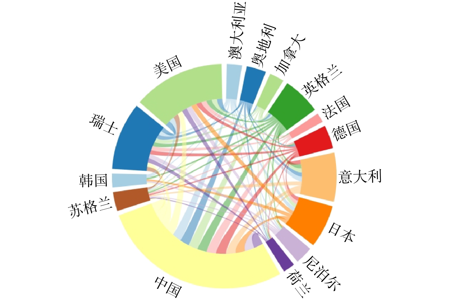
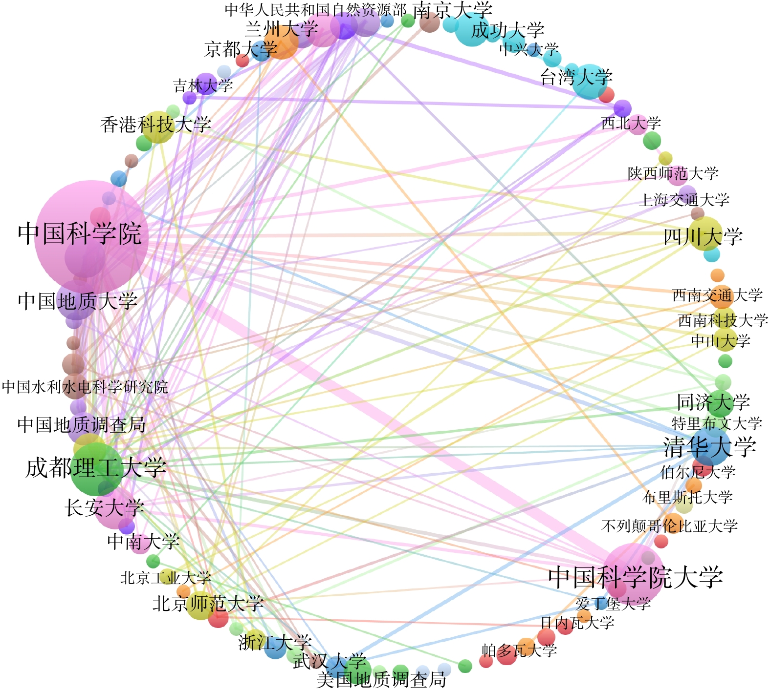
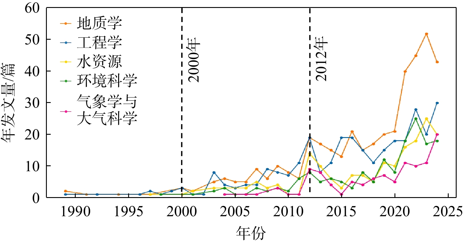
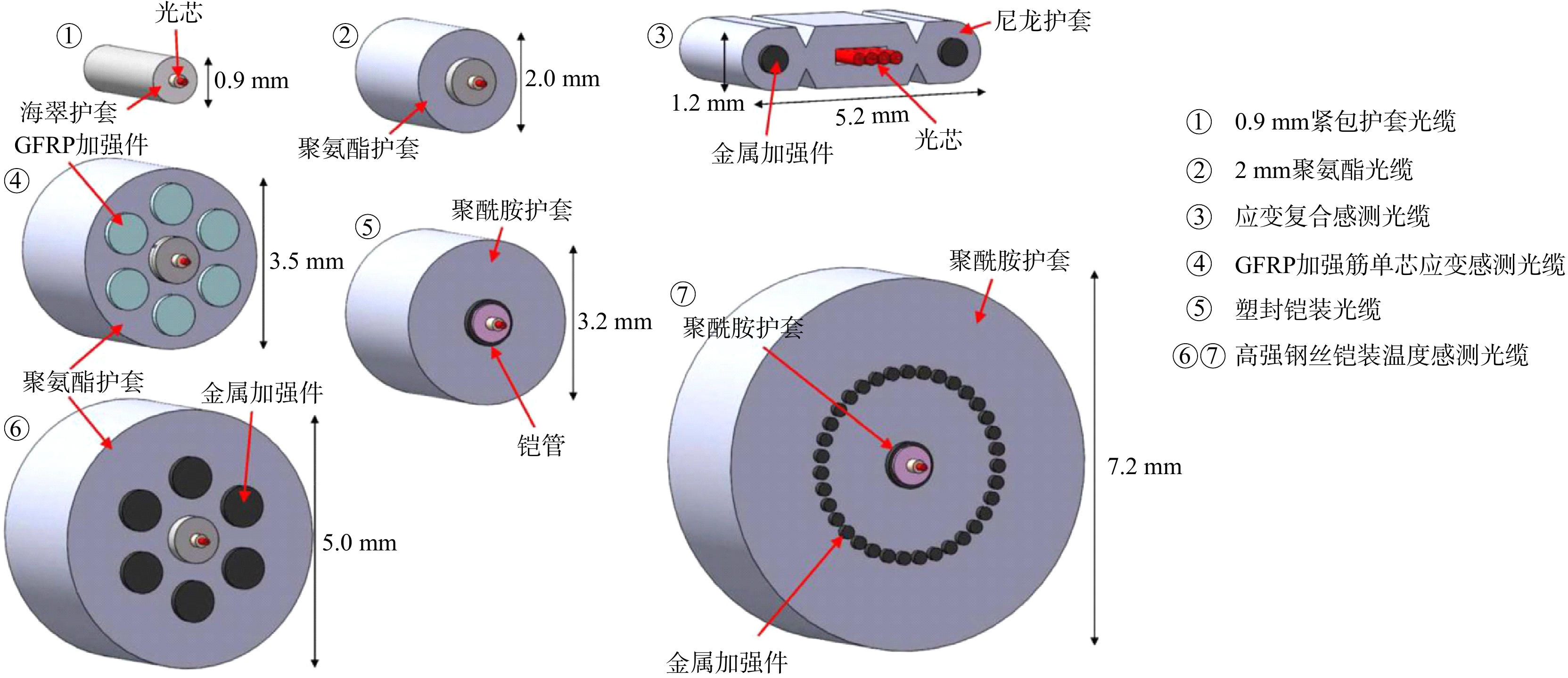
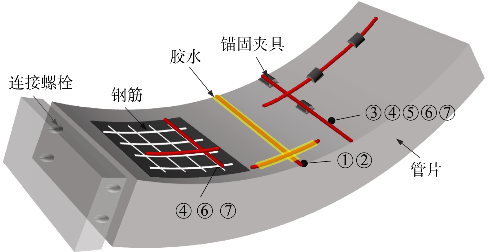
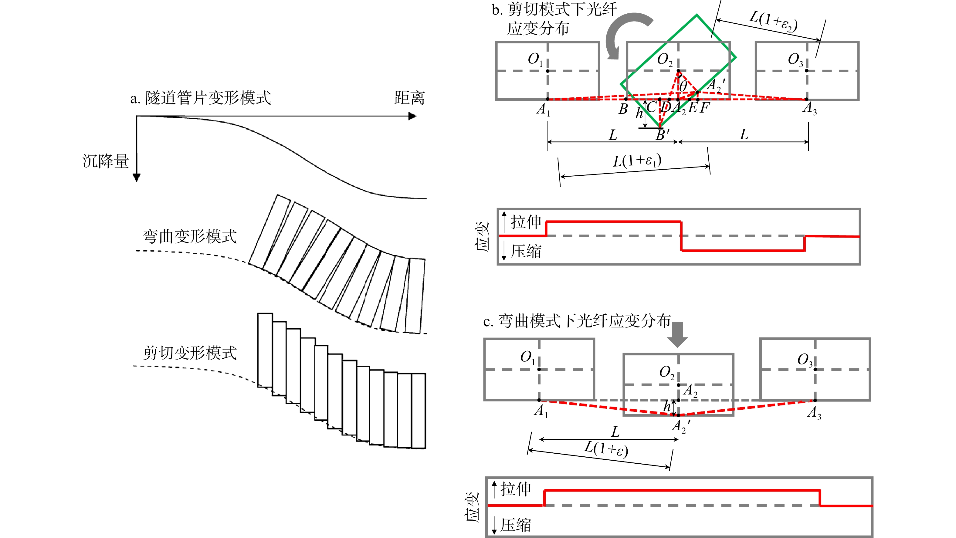
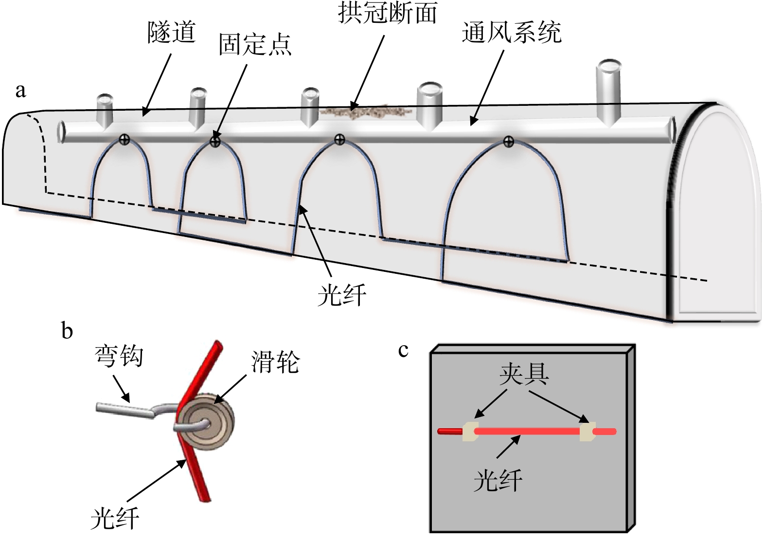
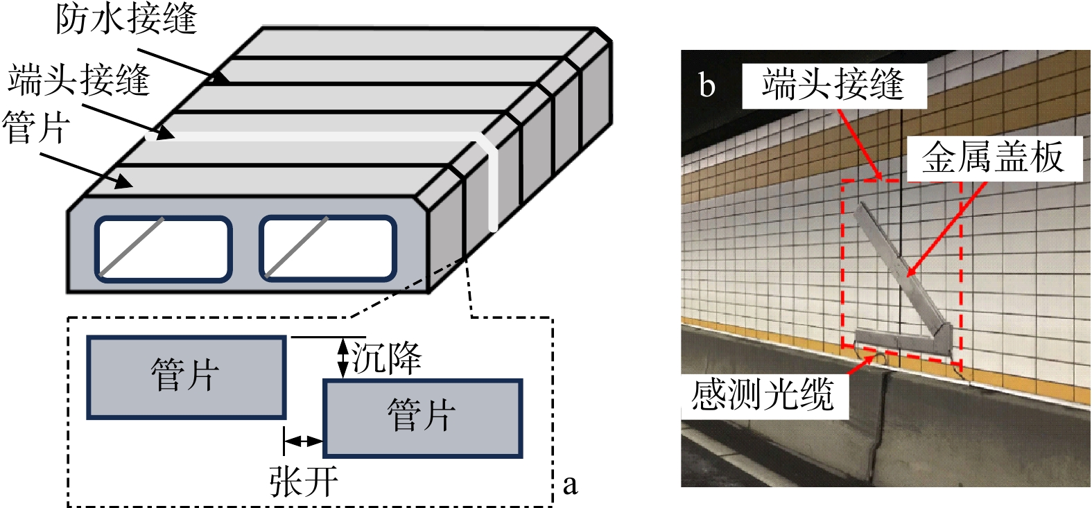
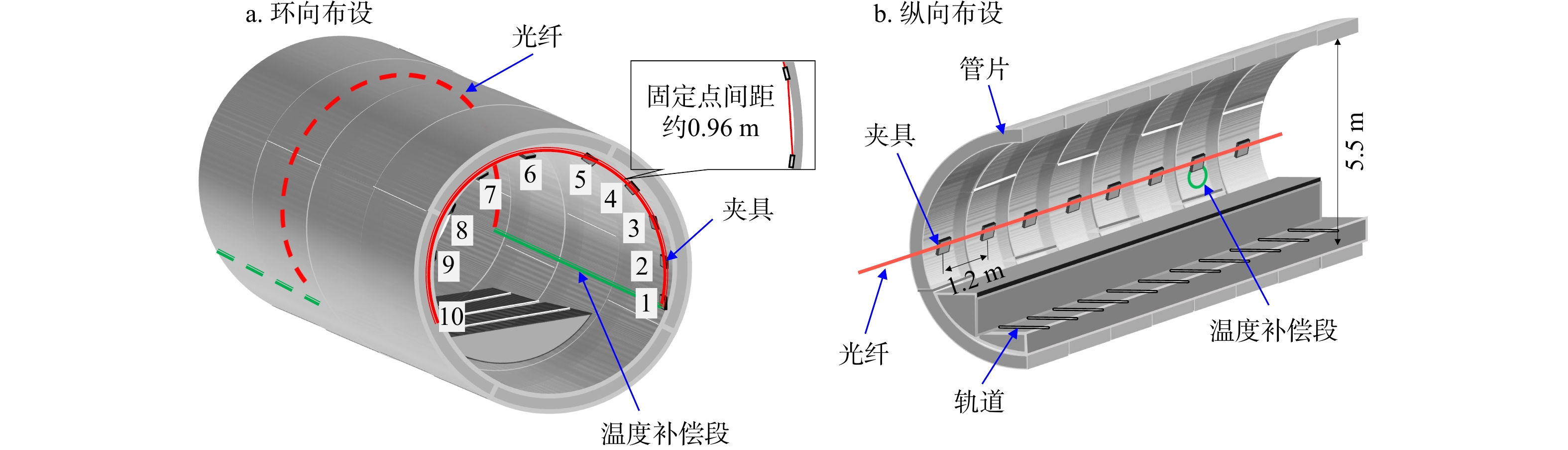
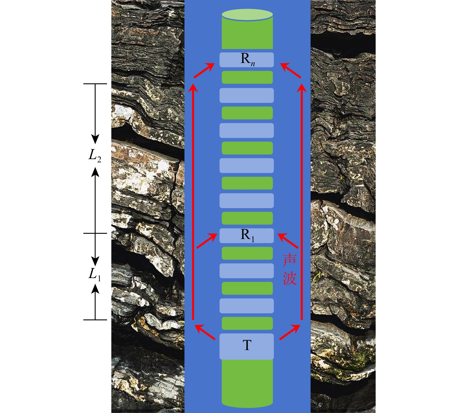
Progress

Combined with practical applications in tunnel engineering monitoring, this paper systematically introduces the fundamental principles, testing modes, and technical characteristics of Brillouin optical time-domain reflectometry (BOTDR) and Brillouin optical time-domain analysis (BOTDA), and reviews their research status and engineering applications in monitoring tunnel stress and deformation. Existing studies show that both BOTDR and BOTDA can provide distributed strain information along the sensing fiber, thereby overcoming the limitations of conventional point-based methods in spatial continuity and coverage. From the perspective of interaction among the sensing cable, tunnel structure, and surrounding rock, the applicability and error characteristics under different tunnel structural forms, fiber deployment methods, and coupling conditions are further analyzed. Particular attention is given to the influence of installation methods, such as surface bonding, groove embedding, internal embedding, and surface-attached laying, on strain transfer behavior and monitoring reliability. In addition, BOTDR and BOTDA are compared in terms of monitoring accuracy, spatial resolution, sensing distance, real-time performance, and adaptability to complex environments, so as to clarify their respective application scopes and technical advantages. The review indicates that monitoring performance depends not only on the sensing technology itself, but also on the coupling quality between the sensing cable and the structure, tunnel type, construction conditions, temperature variation, humidity, and other environmental disturbances.

Conclusions and Prospects

Combined with practical applications in tunnel engineering monitoring, this paper systematically introduces the fundamental principles, testing modes, and technical characteristics of Brillouin optical time-domain reflectometry (BOTDR) and Brillouin optical time-domain analysis (BOTDA), and reviews their research status and engineering applications in monitoring tunnel stress and deformation. Existing studies show that both BOTDR and BOTDA can provide distributed strain information along the sensing fiber, thereby overcoming the limitations of conventional point-based methods in spatial continuity and coverage. From the perspective of interaction among the sensing cable, tunnel structure, and surrounding rock, the applicability and error characteristics under different tunnel structural forms, fiber deployment methods, and coupling conditions are further analyzed. Particular attention is given to the influence of installation methods, such as surface bonding, groove embedding, internal embedding, and surface-attached laying, on strain transfer behavior and monitoring reliability. In addition, BOTDR and BOTDA are compared in terms of monitoring accuracy, spatial resolution, sensing distance, real-time performance, and adaptability to complex environments, so as to clarify their respective application scopes and technical advantages. The review indicates that monitoring performance depends not only on the sensing technology itself, but also on the coupling quality between the sensing cable and the structure, tunnel type, construction conditions, temperature variation, humidity, and other environmental disturbances.

Dynamic mechanism of tight sandstone gas accumulation in northern basin-margin transition zone of Ordos Basin
QI Rong, CAO Qiang, ZHANG Wei, MA Benben, LU Yongchao, YE Jiaren, AN Chuan, LI Chuntang, ZHANG Yuehui, SHI Yongxi
2026, 45(3): 115-129. doi: 10.19509/j.cnki.dzkq.tb20240519
Abstract:
Objective

Due to the westward shift of natural gas exploration strategy in the Hangjinqi area, the First Member of the Shihezi Formation in the Xinzhao East Zone (located in the western part of the Hangjinqi area) has become the main target for natural gas exploration at this stage. Compared with other zones in the Hangjinqi area, the Xinzhao East Zone has the largest burial depth, the poorest physical properties of the Upper Paleozoic sandstone reservoirs, and most of its reservoirs have been highly densified. Existing exploration results confirm that, under conditions of high densification, the First Member of the Shihezi Formation in the Xinzhao East Zone can still form large-scale natural gas charging and accumulation. This study aims to identify the coupling mechanism of driving and resisting forces during the main accumulation period and its controlling effects on gas accumulation, and to reveal the dynamic mechanism of tight sandstone gas accumulation in the transition zone of the northern margin of the Ordos Basin.

Methods

In this study, the quasi-continuous tight sandstone gas of the First Member of the Shihezi Formation in the Xinzhao East Zone of Hangjinqi area, located in the northern basin-margin transition zone of the Ordos Basin, was taken as the main research object. Guided by the theory of reservoir-forming dynamics, reservoir petrology, reservoir-forming chronology, and basin simulation technology were comprehensively used to analyze the mechanism and process of reservoir densification of the First Member of the Shihezi Formation in the Xinzhao East Zone. The charging period and time of natural gas were determined, the relationship between reservoir densification and natural gas accumulation was summarized, and the charging dynamic-resistance evolution process of tight sandstone reservoirs was quantitatively reconstructed. The dynamic-resistance coupling mechanism and its reservoir-controlling effect of tight sandstone gas accumulation in the main accumulation period were summarized.

Results

The results showed that the proportion of tight reservoirs in the First Member of the Shihezi Formation in the Xinzhao East Zone of the Hangjinqi area was more than 50%, and two types of tight sandstone reservoirs (compaction-dominated and quartz cementation-dominated tight types) and one type of dissolution-dominated non-tight reservoir were developed. The main accumulation period of natural gas in the First Member of the Shihezi Formation in the Xinzhao East Zone was the end of the Early Cretaceous (110-100 Ma), and the natural gas was characterized by mixed charging of CO2 and CH4. The tight sandstone reservoirs of the two origins were characterized by densification followed by accumulation, and the natural gas accumulation driving force was greater than the resisting force during the main accumulation period in the Middle and Late Early Cretaceous.

Conclusion

It is proposed for the first time that the gas accumulation net driving force (difference between driving and resisting forces) is greater than 7 MPa, which is a necessary condition for natural gas enrichment in the First Member of the Shihezi Formation in the Xinzhao East Zone of the Hangjinqi area. High net accumulation driving force and favorable sealing conditions may be the key factors for natural gas enrichment in the Xinzhao East Zone of the Hangjinqi area. This study can provide references for the exploration and development of similar oil and gas reservoirs in the basin-margin transition zone of large depression basins, and enrich the theory of tight-low permeability oil and gas accumulation in the basin-margin continuous-discontinuous accumulation transition zone of large depression basins.

Analysis of reservoir characteristics of limestone conglomerate bodies in faulted lacustrine basin and main controlling factors of oil and gas accumulation: A case study of Chenghai fault step zone in Qikou Sag of Bohai Bay Basin
CHEN Changwei, DONG Xiaowei, HUANG Chuanyan, DIAO Liying, REN Sinan, LI Xiaojing, WANG Hongbo, LIU Guoquan, ZOU Leiluo, WU Xuesong, SUN Erpeng
2026, 45(3): 130-143. doi: 10.19509/j.cnki.dzkq.tb20240802
Abstract:
Objective

The faulted basins in eastern China represent significant crude oil production bases. After decades of intensive exploration and development, enhancing the scale and efficiency of conventional oil and gas resource exploitation has become increasingly challenging. Consequently, deep, unconventional, and complex lithological reservoirs have emerged as key exploration targets.

Methods

Based on integrated geological, drilling, and geophysical data from Chenghai fault step zone in Qikou Sag of Bohai Bay Basin, this study systematically analyzed the sedimentary and reservoir characteristics of limestone conglomerate bodies. The main controlling factors of oil and gas accumulation were also investigated to summarize their geological patterns.

Results

The results indicated that during the Early Paleogene sedimentary stage, the Chenghai fault step zone developed fan-delta facies limestone conglomerate bodies, sourced from the Ordovician of Chengning uplift. Three main lithofacies were identified: Limestone conglomerate facies, sandstone facies, and mudstone facies. Reservoir types were classified into four categories: Limestone conglomerate, sandstone-bearing limestone conglomerate, limestone conglomerate-bearing sandstone, and sandstone. The reservoir spaces were dominated by intergranular dissolution pores and fractures. The distribution of limestone conglomerate bodies within the fan delta was controlled by paleo-channels, with thicker reservoirs occurring within these channelized zones. Sandwiched between three sets of effective source rocks (the lower unit of the First, the Second, and Third members of Shahejie Formation), oil and gas migration was facilitated by step faults, unconformities, and reservoir layers, resulting in an overall oil-bearing characteristics of limestone conglomerate bodies. Furthermore, the distribution of high-quality reservoirs was governed by dominant sedimentary microfacies and lithofacies, with fine-grained sandstone facies in subaqueous distributary channels at the fan-delta front exhibiting enrichment and high-yield production.

Conclusion

The study provides a reference for the exploration of limestone conglomerate bodies.

Impact of coal-forming environment of Shanxi Formation in Late Paleozoic of North China Platform on coal seam gas-bearing property
ZHANG Bing, BIE Shizhen, MI Honggang, WANG Xiaoming, JIAO Yangquan, SU Yu, WU Liqun, YUE Liang, MA Zunjing, QIN Chenyang, FU Yiming
2026, 45(3): 144-155. doi: 10.19509/j.cnki.dzkq.tb20240769
Abstract:
Objective

The coal-forming environment plays a pivotal role in coalbed methane enrichment, with previous studies primarily focusing on specific mining areas and coalbed methane blocks. These studies have typically examined the influence of the coal-forming environment on coal seam gas-bearing property from the perspectives of sedimentary environment and coal facies within limited geographic scopes. However, a comprehensive and systematic overview of the overall influence of the coal-forming environment on gas-bearing property, particularly in North China Craton, has been lacking. This research, centered on the North China Craton, aims to address this gap by systematically analyzing the coal-forming environment and gas characteristics of the Shanxi Formation coal seams.

Methods

Based on coal facies and gas content data from the Shanxi Formation coal seams, together with measured data, the study comprehensively summarized the Late Paleozoic coal-forming environment and gas-bearing characteristics of the Shanxi Formation on the North China Platform and explored the impact of the environment on gas-bearing property in coal seams.

Results

The results indicated that the strata of the Shanxi Formation in North China were formed during marine regression, with the shoreline retreating toward the southeast. The coal-forming sequence was categorized into five sedimentary assemblages: Alluvial fan-braided river deposits → meandering river-lacustrine deposits → deltaic deposits → clastic shoreline deposits → coastal shallow-marine carbonate and clastic deposits. The gas-bearing property in the Shanxi Formation exhibited distinct characteristics across different sedimentary assemblages, with higher gas content observed in coal seams formed under deltaic and clastic coastal depositional environments. The coal-forming environment significantly influences coal seam gas-bearing property by affecting coal seam thickness, coal quality, and the lithology and thickness of the roof and floor strata. Generally, higher coalbed methane content is associated with thicker coal seams, higher vitrinite content, lower ash content, denser lithology, and greater thickness of roof and floor strata, as well as a more favorable sealing capacity in the coal-bearing basin. Coal facies parameters, which reflect variations in environmental factors such as hydrodynamic conditions and oxygen levels, along with vertical heterogeneity in coal quality, contribute to differences in gas-bearing property. Peat swamps with high gelation index (GI) and high vitrinite/inertinite ratio (V/I) exhibit deep water coverage and strongly reducing conditions, facilitating vitrinite preservation and higher gas content. Conversely, conditions of high transport index (TI), strong hydrodynamic activity in peat bogs, enhanced oxidation, and elevated inertinite content are unfavorable for hydrocarbon generation, leading to lower gas content.

Conclusion

The research results can provide theoretical references for the exploration and deployment of coalbed methane resources in North China.

New advances in exploration and prospecting potential of phosphate deposits in Yushan-Zhongping area, Central Guizhou
TAI Wenxing, WAN Daxue, DENG Yamei, ZHANG Xialin, ZHAO Ping, LIU Jianzhong, WANG Langlang, LI Junhai, SHAO Yunbin, LI Lei, WU Wenming, ZHANG Shanshan, TAN Lijin, LIU Jingke
2026, 45(3): 156-168. doi: 10.19509/j.cnki.dzkq.tb20250344
Abstract:

The Yushan-Zhongping area is a large concealed phosphate ore concentration area newly discovered in recent years in Central Guizhou. Guizhou Province, as a national strategic reserve base for phosphate ore resources, is currently facing an acute shortage of high-quality phosphate prospecting targets due to the fierce competition in prospecting project approval in the three traditional phosphate ore concentration areas.

Objective

This study aims to address the critical dilemma of the scarcity of high-quality phosphate ore prospecting targets in Guizhou Province, and to explore the potential of new high-quality phosphate ore resources in Central Guizhou so as to provide a reliable target support for the new round of prospecting breakthrough strategic actions in the whole province. Based on the recent exploration achievements of phosphate deposits in the Yushan-Zhongping area, this research carries out an in-depth study on the regional phosphate metallogenic potential.

Methods

We systematically analyze the spatial variation laws of thickness and grade of the b ore layer of the Yangshui Formation, and conduct a comprehensive study on the burial depth characteristics of ore bodies and the regional metallogenic potential of phosphate deposits. In addition, we carry out a systematic comparative study with two typical phosphate ore concentration areas in Guizhou Province, namely Kaiyang-Xifeng and Weng'an-Fuquan, from the perspectives of metallogenic characteristics, ore layer properties and ore body occurrence laws. On this basis, the prospecting potential of the Yushan-Zhongping area is comprehensively evaluated by combining the regional geological setting and drilling engineering data.

Results

The results show that the Yushan-Zhongping area is located in the transition zone between the "Kaiyang-type" and "Wengfu-type" phosphate deposits in terms of geographical location, metallogenic characteristics and lithofacies paleogeographic environment, and it comprehensively possesses the core metallogenic characteristics of both types of phosphate deposits. The thickness and grade of the b ore layer of the Yangshui Formation in this area show a gradual increasing trend from north to south on the whole, reflecting the optimization of regional metallogenic conditions in the southward direction. From the Yushan-Zhongping area to the southern Weng'an-Fuquan phosphate ore concentration area, the burial elevation of phosphate ore bodies is not continuously decreasing with the extension of the ore belt, but may increase or remain basically unchanged instead. We have divided four burial models of phosphate ore bodies in this area, which are dominated by two genetic types: Primary paleogeographic sedimentation and late tectonic movement. Furthermore, a unique occurrence law of phosphate-rich ore bodies in this area is discovered: The phosphate-rich ore bodies are mainly hosted in the middle part of the b ore body, and most of them develop in the dark dense massive phosphorite, with the ore grade positively correlated with the color depth of the phosphorite.

Conclusion

The "transition zone blank area" in the southern part of the Yushan-Zhongping area has superior metallogenic geological conditions, and it has great prospecting potential for forming a giant phosphate ore enrichment area. This area can be used as a strategic reserve of scarce high-quality phosphate ore prospecting targets for the future development of Guizhou Province. The research results not only enrich the metallogenic theory of phosphate deposits in the transition zone of Central Guizhou, but also provide important practical guiding value for the implementation of the "intensive development of rich ore" strategy in Guizhou Province and the sustainable development and utilization of regional phosphate ore resources.

Characteristics of volcanic high-temperature geothermal system and favorable exploration targets in Yanggao-Tianzhen Basin of Datong
SUN Shaochuan, WANG Yanxin, WANG Xinwei, LUO Lu
2026, 45(3): 169-178. doi: 10.19509/j.cnki.dzkq.tb20250043
Abstract:
Objective

This study aims to investigate the characteristics of intraplate volcanic high-temperature geothermal resources in China, with a specific focus on the Yanggao-Tianzhen Basin in Datong, to finely characterize the geological features of these volcanic high-temperature geothermal resources, identify favorable exploration targets, and provide a reference for the exploration of intraplate volcanic high-temperature geothermal resources in China.

Methods

Based on the drilling and geophysical datasets from the Yanggao-Tianzhen region, the identification of heat transfer types, the analysis of the three-dimensional resistivity structure, the enhanced characterization of deep major faults, and the analysis of high-temperature heat source distribution were conducted.

Results

In terms of stratigraphic structure, the Yanggao-Tianzhen Basin was composed of three distinct sequences from top to bottom: Quaternary, Neogene + Paleogene, and Archean. The Quaternary strata served as the regional caprock, facilitating heat transfer mainly through thermal conduction, while thermal convection occurred locally at shallow faults and stratigraphic interfaces. The faults within the basin, trending nearly East-West, played a crucial role in controlling heat distribution and guiding groundwater flow. The burial depth and type of heat sources were key factors influencing the formation and distribution of volcanic high-temperature geothermal resources. These heat sources were buried at depths ranging from 4000 m to 8000 m, showing a significant East-West disparity. The western part of the basin was mainly characterized by shallow heat sources, while the eastern part featured distinct magmatic conduits connecting to shallow strata, and its heat sources were controlled by deep volcanic channels, leading to a much higher geothermal gradient in the eastern region compared to the western region. Specifically, the geothermal gradient in the East was approximately 9℃ per 100 m, whereas in the west, it was around 5℃ per 100 m.

Conclusion

Combining heat source types, heat transfer characteristics, and fault characteristics, six favorable exploration targets within the Yanggao-Tianzhen Basin are proposed, which can be classified into three types: heat conduction type, magmatic eruption type, and deep major fault-controlled type. Among these targets, there are shallow high-temperature and low-resistivity anomaly zones with burial depths less than 3 000 m, covering an area of approximately 216 km2, and this delineates the core scope for the regional geothermal exploration and development.

Control of NW-trending basement faults on Cenozoic basin evolution in Lishui East Sag, East China Sea Basin
GONG Fangjing, YE Qing, QIN Jun, ZHANG Yanzhen, SHEN Chuanbo, WU Lulu
2026, 45(3): 179-193. doi: 10.19509/j.cnki.dzkq.tb20250366
Abstract:
Objective

NW-trending structures are the dominant factor controlling the "north-south segmentation" of rift architecture in the East China Sea Basin, yet studies on their specific control mechanisms of basin evolution remain poorly constrained. To investigate this issue, the study uses the Lishui East Sag as a case study.

Methods

Based on newly acquired 1400 km2 high-precision 3D seismic data from the Lishui East Sag, interpretations and analyses of basement structure, Cenozoic multi-phase rift architecture, fault systems, and magmatic activity were carried out.

Results

The results revealed four NW-trending dextral transfer zones (TZ1-TZ4) in the basement of the Lishui East Sag, which exhibited varying degrees of activity during both the rifting stage and the post-rifting stage. ① During the rifting stage, the NW-trending transfer zones accommodated variations in rift architecture along strike, causing NE-trending faults to branch, distort, or reorient into NW-trending faults. This process segmented NE-trending structural units and led to a structural pattern characterized by "east-west zonation and north-south segmentation." During the rifting episode I (sedimentary period of the Yueguifeng Formation), NW-trending basement faults in TZ1-TZ4 were all active, defining or partially defining sub-sag boundaries. During the rifting episode II (sedimentary period of the Lingfeng Formation), TZ2 and TZ3 remained active, while TZ1 and TZ4 activity greatly weakened. In addition, active segments along NW-trending transfer zones migrated southeastward. ② During the post-rifting stage, NW-trending basement faults continued to influence fault development. Extensional faults were more developed within the NW-trending transfer zones, and reoriented to an EW strike, forming right-stepping en echelon patterns. Additionally, NW-trending basement faults controlled the development of NW-trending valley systems on the eastern Yandang uplift in the eastern part of the sag and served as preferential pathways for volcanic conduits in the post-rifting stage. ③ Integrating seismic data and previous studies, this study proposed that the NW-trending basement faults in the Lishui East Sag originated from the NW-trending thrust fault system formed during the Mesozoic Indosinian orogeny.

Conclusion

In summary, NW-trending basement faults play a crucial role throughout the Cenozoic evolution of the Lishui East Sag, governing its rift architecture, fault systems, magmatic activity, and sediment source pathways. This study provides significant insights into the tectonic evolution of the East China Sea Basin and enhances understanding of how pre-existing basement faults control rift basin development.

Discussion on coupling of hydrothermal organic carbon cycle and mercury
YUN Xinglin, BAO Rui
2026, 45(3): 194-205. doi: 10.19509/j.cnki.dzkq.tb20250026
Abstract:
Significance

Hydrothermal systems are typical extreme environments in the ocean. They link the exchange of energy and material between the deep Earth and the surface and are widely distributed in the global ocean, representing an important component of the ocean. Due to the supply of deep-sourced matter, hydrothermal systems provide abundant nutrients to the ocean, supporting the growth of a large number of hydrothermal organisms and making them a hotspot for organic carbon production. Hydrothermal systems are also an important source of mercury in the ocean, contributing significantly to the global ocean mercury flux. Mercury and organic carbon exhibit strong binding ability, and mercury is deposited into sediments of hydrothermal systems together with organic carbon, recording changes in hydrothermal and volcanic environments and providing an explanation for variations in organic carbon during volcanic and hydrothermal activities. Due to the important role of hydrothermal systems in organic carbon production, the study of hydrothermal systems helps unravel the complex organic carbon cycle and understand the significance of hydrothermal systems in this cycle. Moreover, the study of the coupling of mercury and organic carbon in volcanic and hydrothermal activities is an important approach for investigating changes in organic carbon burial driven by volcanic activities over geological timescales.

Progress

This study reviews the production, burial, and transformation processes of organic carbon in hydrothermal systems, as well as the application of carbon isotopes (δ13C and Δ14C) in research on the hydrothermal organic carbon cycle. It also analyzes and summarizes the coupling of organic carbon and mercury in hydrothermal systems. It is concluded that during major volcanic and hydrothermal events in geological history, mercury contents in sediments within the affected areas show significant deviations, and volcanic and hydrothermal activities are well recorded using mercury as an indicator. Meanwhile, during hydrothermal and volcanic activities, the content and signal characteristics of organic carbon in sediments change significantly, indicating the significant influence of such activities on organic carbon production over long timescales. This is manifested as an increased production of deep-sourced organic carbon. Based on the extensive record of mercury in sediments from hydrothermal and volcanic activities, the influence of these activities on the organic carbon cycle has been studied more precisely.

Conclusion and Prospect

By summarizing previous studies on the organic carbon cycle of hydrothermal systems and the coupling of mercury and organic carbon over geological timescales, this study further highlights future research directions on the coupling of mercury and organic carbon in submarine hydrothermal events and activities, aiming to further improve the understanding of the organic carbon cycle in this complex hydrothermal region and provide a theoretical basis for further research on the global organic carbon cycle.

Study on detection methods of abnormal structural planes in shale reservoirs in the Hongxing area
CHEN Yu, TANG Jun, ZENG Furong, LUO Jiawei, DENG Pei, FENG Zhentao
2026, 45(3): 206-216. doi: 10.19509/j.cnki.dzkq.tb20250290
Abstract:
Objective

Abnormal structural planes in shale reservoirs are divided into hard planes and weak planes. The former is typically represented by limestone interbeds, and the latter includes bedding fractures and natural fractures. Their development characteristics are closely related to reservoir accumulation, hydraulic fracturing, and oil and gas production efficiency. Accurate identification of the types and development intervals of these planes is of great practical significance for the exploration and development of shale oil and gas. Taking shale reservoirs in the Hongxing area as the research target, this study aims to propose a set of effective logging-based detection methods for different types of abnormal structural planes, so as to address the difficult classification and low identification accuracy of these planes in continental shale reservoirs.

Methods

Using the sensitivity of array sonic logging and electrical imaging logging to the lithology and structural characteristics of shale reservoirs, a combined logging detection method based on array sonic logging and electrical imaging logging was adopted for the identification of abnormal structural planes. Firstly, the energy difference between fast and slow shear waves from array sonic logging was used to accurately identify the limestone interbeds and other hard planes. Secondly, the Gini coefficient of electrical imaging logging was introduced, and the development characteristics of bedding fractures were quantitatively characterized by calculating the degree of fluctuation of the Gini coefficient. Finally, combined with the array sonic correlation coefficient and other logging parameters, as well as the dark strips in the acoustic waveform logs, the qualitative identification and quantitative characterization of natural fractures were realized. In the research process, the acoustic energy values and attenuation coefficients were calculated using Fourier transforms and the strain tensor using the computational Fourier transform moiré (STC) method. The variance of the Gini coefficient was used to quantify the degree of fluctuation, and the pearson correlation coefficient of the frequency spectra of fast and slow shear waves was defined as the core parameter for identifying natural fractures.

Results

The research results showed that the energy difference effectively responded to the hard planes of limestone interbeds in the Hongxing area, clearly reflecting their development intervals. The Gini coefficient method addressed the heavy workload and poor performance in traditional single-strip identification of bedding fractures, enabling efficient and quantitative characterization of fracture development. The combination of the abnormally low values of the array sonic correlation coefficient and the dark strips in waveform logs provided an intuitive representation of natural fracture development, allowing visual determination of their positions and scales. Field testing in Well Hong A showed clear differentiation of logging responses for each type of abnormal structural plane, and the identification results were highly consistent with core and lithofacies column data.

Conclusion

Field verification shows that this method enables accurate and rapid identification of the development intervals of limestone interbeds, bedding fractures, and natural fractures in vertical wells. For horizontal wells, due to the lack of electrical imaging logging data, the bedding fracture development intervals cannot be identified, but limestone interbeds and natural fractures can still be quantitatively detected using array sonic logging parameters and waveform logs. Verification with lost circulation data from the horizontal section of Well Hong A confirmed consistency with fracture identification results, demonstrating the method’s feasibility and reliability in horizontal wells. The proposed logging detection method enriches the diversity of identification methods for abnormal structural planes in shale reservoirs and provides a reliable technical reference for precise layer selection and optimized fracturing design in the Hongxing area and similar continental shale reservoirs.

Research progress and prospects of submarine landslide disasters
LIU Xiaolei, CHENG Guangwei, MENG Xiangshuai, LIU Hao, ZHANG Hong
2026, 45(3): 217-234. doi: 10.19509/j.cnki.dzkq.tb20250010
Abstract:
Significance

Submarine landslides are a typical form of submarine mass movement occurring in estuarine deltas, shelf slope breaks, and deep-sea continental slopes. Their remarkable fluidity and long-distance migration capacity can cause severe damage to submarine communication cables, oil and gas production facilities, and other critical marine infrastructures, and it has become one of the major geological hazards threatening the safety of marine engineering activities. With the in-depth advancement of marine resource development and the implementation of marine power strategies in coastal countries, marine engineering is rapidly extending from shallow coastal waters to the deep sea, making the prevention and control of submarine landslide disasters an increasingly urgent practical engineering problem. In-depth analysis of the formation mechanisms of submarine landslides and a systematic summary of their research methodologies are the core steps to achieve accurate prediction and effective prevention of such disasters, which is of great practical significance for ensuring the safe operation of marine engineering and the sustainable development of marine resources.

Methods

At present, most domestic and foreign studies on submarine landslides focus on the analysis of triggering factors, formation mechanisms, and sedimentary characteristics, while few scholars have conducted a systematic and comprehensive review from the perspective of research methodology. Based on the systematic review and in-depth analysis of the latest research progress at home and abroad, this study firstly elaborates on the geomechanical characteristics, occurrence conditions, and applicable scenarios of two typical formation mechanisms of submarine landslides, namely liquefaction landslide and breach landslide. Then, it focuses on reviewing the development history, technical characteristics, application boundaries, and adaptability of three core research methods for submarine landslide research: Physical model tests (including flume tests, rotating flume tests, and centrifuge tests), numerical simulation (including constitutive models and discrete methods), and field observation and in-situ monitoring (including geophysical surveys and multi-type sensor monitoring). On this basis, the key technical challenges faced by the current research of each method are further analyzed and discussed.

Results

The research results clarify the essential differences and occurrence patterns of the two typical formation mechanisms of submarine landslides, and define the geological conditions suitable for the occurrence of liquefaction landslides and breach landslides, respectively. It systematically summarizes the technical advantages, application scope, and existing limitations of physical model tests, numerical simulation, and field observation methods in submarine landslide research, and reveals the significant complementarity of different research methods in terms of technical characteristics and application scenarios. It is found that a single research method is difficult to fully and accurately characterize the entire process of submarine landslide from initiation and evolution to deposition, and that multi-method collaborative research is the only way to realize all-round and in-depth study of submarine landslides. In addition, the study summarizes the technical development trends of various research methods and identifies the key technical bottlenecks restricting in-depth research on submarine landslides at this stage.

Conclusion

Future research on submarine landslides should focus on four key directions: Carrying out interdisciplinary cooperation to reveal the composite mechanisms of multi-factor coupling in submarine landslides; Developing large-scale and refined physical model testing technologies to improve the similarity between model tests and actual engineering conditions; Integrating high-performance computing and artificial intelligence technologies to innovate numerical simulation methods for submarine landslides and improve simulation accuracy and efficiency; Enhancing multi-scale, all-round, and long-term field observation technologies and in-situ monitoring systems, constructing a comprehensive early warning system for submarine landslide disasters. This study systematically organizes the research framework of submarine landslides from a methodological perspective, which not only deepens the understanding of the formation mechanisms and research methods of submarine landslides, but also provides important technical references and research ideas for the prediction, early warning, and prevention of submarine landslide disasters in marine engineering practice.

Effects of inorganic salts on pore structure and permeability of undisturbed loess under wetting-drying cycles
LI Peiyue, HE Qiang, WU Jianhua, CHEN Yinfu, KOU Xiaomei, TIAN Yan
2026, 45(3): 235-244. doi: 10.19509/j.cnki.dzkq.tb20240711
Abstract:
Objective

The infiltration of inorganic salt solutions during wetting-drying cycles significantly affects the structural strength and stability of undisturbed loess. This study aims to investigate the impact of inorganic salts on the pore structure and permeability of undisturbed loess under wetting-drying cycles.

Methods

To achieve this objective, loess samples were collected from the South Plateau in Jingyang County, Shaanxi Province. Through laboratory experiments, this study systematically analyzed the variations in permeability and pore structure of undisturbed loess under different wetting-drying cycle conditions and different concentrations of sodium chloride solution, as well as the associated soil-water interaction mechanisms.

Results

The results indicated that wetting-drying cycles reduced the permeability of undisturbed loess, and the saturated permeability coefficient of undisturbed loess decreased with the increase in the number of wetting-drying cycles. The sodium chloride solution increased the permeability of undisturbed loess, and this effect became more pronounced with increasing solution concentration. Wetting-drying cycles promoted the development of fissures on the surface of undisturbed loess and increased the number and area ratio of micropores, thereby reducing effective porosity of the soil mass and resulting in a more compact soil structure. The infiltration of sodium chloride solution promoted the dissolution of minerals such as gypsum and halite, leading to enhanced pore development and increased permeability.

Conclusion

This study improves the understanding of changes in loess structure and permeability under the combined effects of wetting-drying cycles and inorganic salt solution infiltration, providing scientific support for soil and water conservation and engineering construction in loess regions.

Risk assessment of Rangduchang North landslide in Wanzhou District, Three Gorges Reservoir area
WU Yiping, YI Yucong, LI Shuo, CHEN Rui, MIAO Fasheng
2026, 45(3): 245-254. doi: 10.19509/j.cnki.dzkq.tb20250018
Abstract:
Objective

Wanzhou district of Chongqing, as the core area of China's Three Gorges Reservoir area, is characterized by complex geological structure and frequent landslide disasters due to the combined effects of periodic fluctuation of reservoir water level and heavy rainfall. In this area, about 20 new deformed landslides are added annually, which directly threaten the safety of nearly 100000 people and restrict the sustainable urban development of the reservoir area. Therefore, conducting a systematic quantitative risk assessment of individual landslides is of great practical significance for the prevention and mitigation of geological disasters in the Three Gorges Reservoir area.

Methods

In this study, the Rangduchang North landslide in Wanzhou District was taken as the research object to carry out a comprehensive risk assessment of a single landslide disaster. The research process was carried out in three steps: First, based on the basic data obtained from field investigation, on-site sampling tests and water injection tests, the instability probability analysis of the landslide under different working conditions was carried out by using GEO-Studio, and the motion process simulation of the landslide was completed by using DAN3D, and the comprehensive hazard evaluation results of the Rangduchang North landslide were obtained by integrating the two sets of results, with the working conditions including natural self-weight with surface load conditions and rainfall conditions with different return periods of 20, 50 and 100 years. Second, combined with the analysis of the disaster resistance capacity of disaster-bearing bodies in the landslide affected area, a quantitative vulnerability assessment was carried out from two dimensions of population vulnerability and economic vulnerability, in which the economic vulnerability covered three types of disaster-bearing bodies including residential buildings, transportation roads and land resources, and the specific vulnerability values of various disaster-bearing bodies were determined. Finally, the comprehensive risk assessment of the Rangduchang North Landslide was realized by superposing the three core elements of hazard of landslide disasters, vulnerability and economic value of disaster-bearing bodies, and the population casualty risk and economic loss risk of the landslide under extreme conditions were calculated in detail.

Results

The results showed that the Rangduchang North landslide was in a stable state under the natural self-weight and surface load conditions, while all in a slightly unstable state under rainfall conditions with different return periods. Specifically, under the 10-day rainfall condition with a 100-year return period, the landslide had a stability coefficient of 1.011 and a failure probability of 23.53%. Under this extreme rainfall condition, the total population casualty risk caused by the instability and failure of the Rangduchang North landslide was 2 people, including 1 casualty risk for indoor population, 1 for outdoor population, and 0 for floating population on traffic roads in the affected area. The total economic loss risk was 1.141 million yuan, which was composed of three parts: 121000 yuan for residential building damage, 1000000 yuan for transportation road damage and 15000 yuan for land resource damage.

Conclusion

This study has accurately quantified the instability probability, vulnerability of disaster-bearing bodies and comprehensive risk value of the Rangduchang North landslide under extreme rainfall conditions, and clarified the specific distribution characteristics of population casualties and economic losses caused by landslide instability. A systematic quantitative risk assessment framework for a single landslide was constructed by combining multiple numerical simulation software and quantitative vulnerability evaluation models, which not only provides specific data support and technical guidance for the prevention and mitigation of geological disasters in Rangdu Town, but also serves as a reference paradigm for the risk assessment of similar single landslides in the Three Gorges Reservoir area. In general, the research results have important practical significance for the overall geological disaster prevention and mitigation work in the Three Gorges Reservoir area and can provide a useful reference for the geological safety management of reservoir areas with similar geological conditions worldwide.

Failure mechanism of natural soft soil slopes based on resistivity method
YE Chao, CHENG Qian, SUN Hong, TANG Xue
2026, 45(3): 255-264. doi: 10.19509/j.cnki.dzkq.tb20250051
Abstract:
Objective

Natural soft soil slopes are commonly formed during underground excavation in soft soil areas and are highly susceptible to structural instability and other failures under overloading conditions.

Methods

To investigate the failure of natural soft soil slopes, undisturbed in situ soft soil slope model tests were conducted, and the failure modes and micro-mechanisms of slopes under overloading were analyzed based on the resistivity method.

Results

The results showed that the resistivity of the whole slope ranged from 1.5-4 Ω·m, and resistivity and water content exhibited a negative logarithmic relationship. Under an overload of 60 kPa, the water content contours of the slope were distributed diagonally from the slope crest to the slope surface. The current conduction paths and conduction distances between soil particles within soft soil varied to different degrees, leading to a gradual decrease in the variation of resistivity from top to bottom of the soil body, reflecting differences in the microstructure of the soft soil. Microstructural changes are the primary cause of slope failure. According to the characteristics of the cumulative resistivity variation, the microstructural changes are divided into three regions along the slope height H: 0-0.32H as the strong-change region, 0.32H-0.60H as the medium-change region, and >0.60H as the weak-change region. Natural soft soil slopes under overloading mainly undergo tensile cracking-bulging-dislocation failure.

Conclusion

The research results can provide experimental evidence and theoretical references for the stability evaluation and engineering reinforcement of natural soft soil slopes.

Efficient reliability analysis of soil slopes by combining strength reduction sampling with SVM surrogate model
LU Jian, ZENG Peng, FENG Bing, WANG Xin, YAN Zulong
2026, 45(3): 265-276. doi: 10.19509/j.cnki.dzkq.tb20240756
Abstract:
Objective

Landslides caused by slope instability have posed a considerable threat to human lives and property, especially under the background of rapid infrastructure development and drastic global climate change. Traditional slope stability evaluation methods usually ignore the randomness of soil parameters, and conventional reliability analysis approaches such as monte carlo simulation (MCS) suffer from excessively high computational costs, which seriously restrict their practical engineering applications.

Methods

To address these problems, this study develops a novel and efficient method for reliability analysis of soil slopes, termed strength reduction sampling-support vector machine (SRS-SVM), by integrating the finite difference strength reduction sampling strategy and an active learning support vector machine surrogate model. The proposed method employs strength reduction sampling to generate highly informative training points strictly near the limit state surface (LSS), where one single numerical model evaluation can produce three key samples, thus remarkably improving the training efficiency of the SVM surrogate model. Meanwhile, an improved active learning function based on k-fold cross-validation and jackknifing estimation is adopted to select points with high uncertainty close to the LSS, and a convergence criterion based on the stability of system failure probability is applied to balance computational accuracy and efficiency. Four typical slope cases, including a single-layer soil slope, a two-layer clay slope, a three-layer slope with four random variables, and a four-layer complex dam slope with six random variables, are adopted to verify the performance of the SRS-SVM method. The proposed method is compared with several classic reliability approaches, such as the classical response surface method (CRSM), radial basis function (RBF), and strength reduction sampling-gaussian process regression (SRS-GPR).

Results

The results demonstrate that the SRS-SVM method requires fewer than 40 numerical model evaluations for all cases, and the absolute relative errors of the system failure probability are controlled within 1.5%, showing overwhelming advantages over traditional methods in both computational efficiency and accuracy. Furthermore, the method presents strong adaptability in dealing with highly nonlinear performance functions and multi-variable complex slope conditions.

Conclusion

This study combines the high-efficiency sampling characteristic of strength reduction technique and the superior classification ability of SVM, providing a new high-performance solution for accurate and fast reliability analysis of soil slopes. The SRS-SVM method has broad application prospects in practical engineering risk assessment, disaster prevention and mitigation of slopes, and can effectively support the reliability-based design of geotechnical engineering under uncertain conditions.

Experimental study on inhibition of rainfall infiltration into slopes by different dual-structure capillary barrier layers
WANG Ke, WU Qinghua, YANG Ye
2026, 45(3): 277-286. doi: 10.19509/j.cnki.dzkq.tb20250009
Abstract:
Objective

Soil slopes are prone to crack development under the cyclic effects of rainfall and evaporation, which causes rainfall to infiltrate into the soil, reduce the mechanical properties of soil mass, and further induce slope instability. Currently, the mainstream slope protection measures mainly rely on surface hardening technologies, which are susceptible to cracking and failure during long-term operation, leading to re-infiltration of rainfall and failing to achieve long-term stable protection of slopes. Under the background of integrating slope disaster prevention with ecological civilization construction and following the principle of ecological priority, this study proposes a slope protection method that inhibits rainfall infiltration by using a fine/coarse-grained unsaturated capillary barrier layer (CBL) with ecological functions, seepage prevention, and drainage capabilities, aiming to block rainfall infiltration from the source and provide a new technical approach for ecological restoration and stability control of soil slopes.

Methods

To reveal the influence of CBL lithologic structure and rainfall intensity on the regulation of rainfall infiltration patterns and slope protection performance, a series of indoor physical model tests were conducted, with the combination of CBL lithology and rainfall intensity as the key test variables. Specifically, two typical rainfall intensities (1.93×10⁴, 4.73×104 cm/s) were set, and four CBL lithologic structure combinations (sub-sandy soil/coarse sand, sub-sandy soil/gravel sand, sub-sandy soil/breccia, sub-sandy soil/gravel) were designed. The tests systematically monitored the wetting front migration process, drainage initiation time, stable drainage intensity, and cumulative drainage volume of CBL under different working conditions, and quantitatively analyzed the effects of coarse-grained layer particle size, particle morphology, and rainfall intensity on the water migration characteristics and drainage efficiency of CBL.

Results

The results showed that: ① Rainfall mainly moved in the form of uniform flow in the fine-grained layer, and the migration velocity increased with the increase of particle size of the coarse-grained layer, which was significantly affected by the particle morphology of the coarse-grained layer. When rainfall infiltrated to the fine/coarse-grained layer interface, the water migrated to the slope toe along the interface driven by both gravity and matrix suction. After the rainfall broke through the fine/coarse-grained layer interface, it continued to move in the form of uniform flow in the coarse sand and gravel sand layers, while it moved in the form of preferential flow in the breccia and gravel layers, and the degree of preferential flow was enhanced with the increase of particle size of the coarse-grained layer. ② The stable drainage efficiency of CBL (the ratio of stable drainage intensity to rainfall intensity) decreased with the increase of rainfall intensity. At high rainfall intensity, it showed a slight increase with the increase of particle size of the coarse-grained layer, but the amplitude of increase was limited. The comprehensive drainage efficiency of CBL (the ratio of total lateral drainage to total rainfall) increased with the increase of both particle size of the coarse-grained layer and rainfall intensity, and the growth rate decreased more significantly with the increase of rainfall intensity. ③ The particle morphology of the coarse-grained layer had a pronounced effect on the rainfall-blocking performance of CBL. The sub-sandy soil/breccia CBL exhibited the optimal performance in inhibiting rainfall infiltration into the slope, effectively preventing rainfall from infiltrating into the slope clay layer within the range of test rainfall intensities, with the stable drainage efficiency reaching 96.74% under low rainfall intensity and 92.81% under high rainfall intensity, and the comprehensive drainage efficiency reaching 82.42% and 98.41% respectively under the two rainfall intensities.

Conclusion

This study reveals the intrinsic mechanism of rainfall infiltration inhibition by dual-structure CBL and clarifies the optimal lithologic combination form of CBL for slope protection. Its innovation lies in the systematic exploration of the coupling effects of coarse-grained layer particle size, particle morphology, and rainfall intensity on the performance of CBL, as well as the verification of the superior seepage prevention and drainage performance of the angular particle breccia-based CBL through quantitative physical model tests. The research findings provide important theoretical reference and technical support for the stability control and ecological protection engineering design of soil slopes, and can also be applied to the fields of energy storage leakage prevention, environmental restoration, and ecological governance.

Genesis mechanism of geothermal water in Yinchuan Basin: Constraints from hydrochemistry and isotopes
CAO Yuanyuan, HU Xinjun, NI Ping, JIANG Long, WANG Liwei, YANG Jing, CHEN Xiaojing, YU Zhaoyang, SHANG Jianbo, LIU Mingliang
2026, 45(3): 287-302. doi: 10.19509/j.cnki.dzkq.tb20250032
Abstract:
Objective

Geothermal resources have advantages such as renewability, high energy utilization efficiency, and energy conservation and emission reduction. As an important renewable energy for promoting energy transition and achieving the "double carbon" goals, although the Yinchuan Basin is rich in geothermal reserves, the genesis of its geothermal water remains unclear due to the lack of systematic hydrogeochemical and isotopic research, and their development lacks scientific planning and unified management, which not only slows down the development process of geothermal resources but also seriously hinders the green rapid local economic development.

Methods

This study focused on water samples from typical geothermal wells in the Yinchuan Basin and divided them into western, central, and eastern regions according to their locations. Combined with the regional geological structure background, by analyzing and testing the hydrochemical and isotopic characteristics of geothermal water and cold groundwater, the study investigated the geochemical origin, runoff circulation processes, and heat sources of geothermal water in the study area, and analyzed the genesis mechanism of the geothermal system.

Results

The results showed that the main hydrochemical types of geothermal water in this study area were Cl-Na type and Cl·SO4-Na type. Hydrogen and oxygen isotopes indicated that the geothermal water was mainly recharged by atmospheric precipitation, and the recharge elevation ranged from 1616 m to 2964 m. Hydrochemical characteristics, combined with chlorine, strontium, and sulfur isotopes indicated that the material sources of geothermal water were mainly high-temperature conditions of water-rock interaction, rock salt dissolution, and the input of paleo-sedimentary water. Reservoir temperatures in the study area ranged from 78.9 °C to 109.2 °C, and the circulation depths of geothermal water ranged from 3455.4 m to 24794.0 m. The results of ion ratio coefficients and 14C dating showed that geothermal water in the central region had the highest hydrochemical component contents, the longest circulation period, and the greatest circulation depth compared with the western and eastern regions. Based on geothermal water hydrochemical characteristic analysis and quantitative calculation of granite heat production rates, it was calculated that the heat source of the geothermal system in the study area was mainly terrestrial heat flow, excluding magmatic heating and radioactive element decay heating.

Conclusion

This study clarifies the key hydrogeochemical characteristics and genesis mechanism of geothermal resources in the Yinchuan Basin, and establishes a conceptual model of the geothermal system genesis, providing an important theoretical and practical basis for the subsequent scientific and rational development and utilization of geothermal resources and promoting green high-quality economic development in the region.

Non-Fickian phenomenon of solute transport in hierarchical groundwater flow systems of homogeneous sandbox aquifer
GAO Yipan, SUN Ronglin, HE Shiwei, WANG Run
2026, 45(3): 303-313. doi: 10.19509/j.cnki.dzkq.tb20250044
Abstract:
Objective

Groundwater solute transport is a core research content in hydrogeology, and the non-Fickian phenomenon widely existing in the transport process is the key to revealing the intrinsic mechanisms of solute migration. Traditional studies have mostly focused on the non-Fickian phenomenon caused by the heterogeneity of aquifer media, while the research on solute transport in homogeneous aquifers under the hierarchical groundwater flow system model remains relatively limited. This study aims to investigate the non-Fickian phenomenon of solute transport at the discharge points and inside the homogeneous sandbox aquifer with hierarchical groundwater flow systems, as well as its key influencing factors. It is also intended to clarify the manifestation patterns and dominant controlling factors of the non-Fickian phenomenon under the hierarchical flow system model in homogeneous aquifers, and to provide experimental and theoretical basis for the prevention, control, and treatment of groundwater pollution in complex nested basins.

Methods

Based on the combination of laboratory sandbox physical experiments and COMSOL Multiphysics numerical simulation, three different groundwater flow patterns were constructed in the aquifer by adjusting the rainfall infiltration intensity: single regional flow system, local + regional two-level flow system, and local + intermediate + regional three-level flow system. The dynamic monitoring of solute transport at river valley discharge points and internal monitoring points of the aquifer was carried out, and the non-Fickian characteristics of solute transport were systematically analyzed by using the breakthrough curve of solute transport as the core analysis index.

Results

The analysis of solute transport breakthrough curves showed that in the same flow pattern, the significance degree of the non-Fickian phenomenon in different hierarchical flow systems followed the order of regional flow system > intermediate flow system > local flow system. Among different groundwater flow patterns, the significance degree of the non-Fickian phenomenon was ranked as single regional flow system > local + regional two-level flow system > local + intermediate + regional three-level flow system. Distinct non-Fickian transport characteristics of early arrival and tailing were observed at both the river valley discharge points of the physical sandbox and the internal monitoring points of the numerical sandbox, directly reflecting the non-Fickian phenomenon in the hierarchical flow system of the homogeneous aquifer.

Conclusions

The non-Fickian phenomenon of solute transport in the hierarchical groundwater flow systems of the sandbox aquifer is jointly affected by groundwater flow velocity, solute transport path, and rainfall infiltration intensity, with notable differences in the dominant influencing factors of aquifers at different depths. The non-Fickian phenomenon in the shallow aquifer is more significantly affected by groundwater flow velocity, while that in the deep aquifer is mainly controlled by the solute transport path, with a longer path leading to a more obvious non-Fickian tailing phenomenon. There is a significant negative correlation between rainfall infiltration intensity and the non-Fickian phenomenon in the deep aquifer, meaning the smaller the rainfall intensity, the more prominent the non-Fickian tailing phenomenon in the deep part, while rainfall infiltration intensity shows no obvious correlation with the non-Fickian phenomenon in the shallow aquifer. This study enriches the theoretical system of solute transport in hierarchical groundwater flow systems of homogeneous aquifers, and provides important scientific reference for the practical evaluation and remediation of groundwater pollution in nested basins.

Impact of groundwater level changes on land subsidence in Tianjin Plain area
ZHU Jinglei, ZHENG Lizhi, WU Xiao, WU Min, LYU Xiaowen, HUANG Meng
2026, 45(3): 314-326. doi: 10.19509/j.cnki.dzkq.tb20240762
Abstract:
Objective

In recent years, Tianjin has significantly reduced deep groundwater extraction through measures such as inter-basin water transfer and strict control of groundwater extraction. As a result, the groundwater levels in the plain area have shown an overall rising trend, and the rates of land subsidence have slowed. Against the backdrop of groundwater level recovery, this study examines the effects of regulated groundwater extraction and artificial recharge on groundwater level changes and land subsidence responses in Tianjin Plain area. It helps control the decline rate of groundwater levels and optimize water resource utilization, and also contributes to future control of urban land subsidence and the reduction of land subsidence risk.

Methods

Using the MODFLOW-SUB module in Groundwater Modeling System (GMS), a coupled groundwater flow-land subsidence model was established for the study area. After validation, different groundwater extraction and artificial recharge schemes were designed to simulate and predict changes in deep groundwater levels and land subsidence from 2023 to 2025.

Results

The results showed that increasing the current groundwater extraction volume by 2-4 times would intensify groundwater level decline in the depression cone areas of Jinghai District and northeastern Binhai New Area, with a decrease of about 0.02-0.17 m, thereby accelerating land subsidence. When extraction was reduced by 50%, groundwater levels increased slightly by 0-0.02 m, demonstrating insignificant mitigation effects on land subsidence. The recharge scheme affected groundwater level recovery over a maximum area of 250.04 km2, raising groundwater levels by 0.14-0.50 m and causing ground rebound of 0.25-0.75 mm in the depression cone areas, showing a relatively good effect on mitigating land subsidence compared with the extraction scheme. At present, groundwater extraction should not be increased near deep groundwater depression cones in the study area. Instead, groundwater extraction should be appropriately reduced, and artificial recharge should be gradually incorporated to promote groundwater level recovery, thereby achieving the goal of restoring groundwater resources and alleviating compression of deep aquifer formations in the plain area.

Conclusion

The findings provide a scientific basis for land subsidence control in Tianjin.

Two-dimensional SNMR imaging based on HED integration under undulating terrain conditions
HUAI Yulu, PAN Jianwei, LUO Haixin, QIAN Lun, LI Tao, LIU Yi, YANG Chen
2026, 45(3): 327-338. doi: 10.19509/j.cnki.dzkq.tb20240801
Abstract:
Objective

Traditional surface nuclear magnetic resonance (SNMR) methods often neglect terrain conditions during forward modeling, which affects the accuracy of two-dimensional imaging. If the excitation electromagnetic field is still calculated using traditional SNMR methods under such conditions, the accuracy of two-dimensional imaging will be compromised. This study analyzes the characteristics of SNMR response signals under undulating terrain based on the harmonic electric dipole (HED) integral method, revealing that terrain is a key factor affecting inversion results.

Methods

Numerical simulations were conducted to establish two geological models: Monoclinal and embankment models. And a comparative analysis was performed on SNMR two-dimensional signal characteristics and inversion results under different terrain conditions.

Results

The results showed that SNMR two-dimensional inversion incorporating undulating terrain achieved better agreement with preset models in terms of water-bearing body location, geometry, and water content. The HED integral method could overcome the influence of terrain factors, effectively enhancing the identification capability of water-bearing body boundaries and the overall continuity of aquifers under undulating terrain conditions. Field validation at Hongfeng Lake in Guiyang, combined with electrical resistivity tomography (ERT), showed that the HED-based SNMR two-dimensional inversion under undulating terrain clearly visualized subsurface water distribution, accurately delineated aquifer locations and geometries, and better reflected the complexity of aquifer lateral distribution, thereby enhancing inversion accuracy.

Conclusion

The experimental results verify that the HED integral method better adapts to complex terrain conditions and provides technical support as well as methodological reference for high-precision groundwater detection.

Three-dimensional modeling and visualization analysis of primary exhalative-sedimentary cycles of Gaodi-Daotuo manganese deposit, Guizhou Province
TIAN Yiping, WU Chonglong, ZHANG Xialin, ZHANG Sui, YUAN Liangjun, LI Yan, CAI Guorong
2026, 45(3): 339-348. doi: 10.19509/j.cnki.dzkq.tb20250008
Abstract:
Objective

To verify the new metallogenic model of "manganese-bearing gas-liquid diapir exhalative-sedimentation and quasi-syngenetic multiple charging composite mineralization" for the "Datangpo-type" manganese deposit, this study takes the Gaodi-Daotuo super-large rhodochrosite deposit in Guizhou Province as the research object to conduct fine modeling of exhalative-sedimentary cycles and three-dimensional (3D) visualization analysis, aiming to reveal the ore-forming laws of the deposit and provide direct support for the deep and peripheral metallogenic prediction of such deposits.

Methods

First, the drill cores (ore cores) in the ore-bearing segment of each exploration line of the deposit were divided and correlated for sedimentary cycles, and a series of profile maps of manganese-bearing fluid exhalative-sedimentary cycles were compiled. On this basis, 3D structural model of sedimentary cycles was constructed by adopting the method combining sedimentology knowledge-driven serial profile topological reasoning and layer surface modeling. Meanwhile, combined with the Triangulated Irregular Network-Corner Point Grid (TIN-CPG) hybrid data model, 3D attribute model of manganese content was established by using the multi-point geostatistical random attribute modeling method based on Corner Point Grid (CPG), and finally an integrated 3D geological model with coupled structure and attribute was formed.

Results

This study successfully constructed an integrated 3D model of five stages of exhalative-sedimentary cycles in the study area. Through 3D visualization analysis including layered visualization, vector clipping and geological statistical analysis, the stages, intensity variation and mineralization process of manganese-bearing fluid exhalative-sedimentation in the deposit were directly and vividly revealed: the exhalative activity was relatively weak in the first cycle, while the third and fourth cycles had the strongest exhalative intensity, where the high-grade manganese ore bodies (w(Mn)≥25%) were mainly concentrated. The multi-level verification results show that the fine modeling method of exhalative-sedimentary metallogenic cycles is scientifically feasible. The distinctive features of this study lie in the proposed 3D structural reasoning modeling method for multi-stage sedimentary cycles driven by sedimentology knowledge, as well as the constructed 3D geological model that reflects multi-stage fine exhalative-sedimentary cycles.

Conclusion

The research results not only provide intuitive visual evidence for the new metallogenic model of Datangpo-type manganese deposit, but also reveal the unique exhalative-sedimentary metallogenic environment, spatial characteristics and ore-forming process of this super-large manganese deposit from the 3D visualization perspective, which is helpful for understanding the ore-forming mechanism, occurrence and distribution characteristics of the deposit, and provides a structural-attribute integrated 3D geological model for the subsequent deep and peripheral metallogenic prediction of such deposits.

Complex contour reconstruction of geological bodies based on fuzzy matching and multi-feature constrained interpolation
YAO Jinpeng, JIAN Xingxiang, ZHOU He, YANG Yi, HE Mengyu, MAO Wenzhe, ZHAO Yang
2026, 45(3): 349-361. doi: 10.19509/j.cnki.dzkq.tb20240606
Abstract:
Objective

To address the problems of low matching accuracy, topological distortion, and geometric deformation caused by significant contour feature differences in adjacent geological body contour reconstruction, and to overcome the limitations of full-mapping matching, this study proposes a complex contour reconstruction algorithm based on fuzzy matching and multi-feature constrained interpolation.

Methods

Initially, the method integrated vertex spatial positions, local adjacency relationships, and global contour features to establish a fuzzy-domain matching strategy. Vertex similarity between adjacent contours was evaluated, and one-to-one mappings between similar vertices were constructed. Based on the matching results, maximum proximity contours between the source and target contours were generated. Subsequently, linear interpolation and discrete polygon evolution were applied to handle transitional shapes between maximum proximity contours and between original and maximum proximity contours, respectively. Finally, three-dimensional reconstruction was performed on the interpolated contour sequence based on the matching results, using bounding-box-constrained geometric transformation correction. Reconstruction tests were conducted using three sets of typical geological exploration-line profile data. The standard GOCAD reconstruction algorithm was selected as the baseline, and improved algorithms with local and global optimization constraints were introduced for systematic comparison.

Results

The results showed that the proposed method effectively resolved the problems of contour self-intersection and topological disorder in conventional reconstruction approaches. Evaluations using a geometric assessment system-comprising triangle similarity, span length, and spatial angles-demonstrated that the reconstructed triangulated irregular network (TIN) models exhibited significant advantages in geometric accuracy and topological consistency.

Conclusion

The proposed approach reduces the dependency of contour interpolation on matching results and provides both algorithmic innovation and theoretical references for addressing correspondence and interpolation problems in contour reconstruction.

Three-dimensional implicit modeling method for complex ore bodies based on inter-layer contour interpolation and normal optimization
CHENG Junjie, LIU Gang, WU Xuechao, FAN Wenyao, CHEN Genshen
2026, 45(3): 362-373. doi: 10.19509/j.cnki.dzkq.tb20240764
Abstract:
Objective

Three-dimensional ore body modeling is the core foundation for the construction of digital mines and intelligent mines. To address the key problem in implicit ore body modeling where sparse intervals between contour lines make it difficult to effectively extract geological constraints, a three-dimensional reconstruction method based on an Hermite radial basis function (HRBF) implicit modeling framework was proposed. This method constructed an ore body model by integrating inter-layer contour interpolation and normal optimization techniques.

Methods and Results

First, the original contour data were homogenized based on a cubic spline closed curve fitting method, and contour mapping starting points were established through rectangular bounding box partitioning. The control point mapping relationships were dynamically adjusted according to the ratio of local contour length to total contour length, effectively solving the correspondence problem among control points of complex contour lines. To solve the problem that normal gradient constraints of ore body contours are difficult to extract, a baseline normal-driven local point selection strategy and a normal ambiguity elimination mechanism were developed, thereby improving the accuracy and topological consistency of boundary normal gradients. Finally, implicit surface visualization was achieved based on the marching cubes method, and a complex three-dimensional ore body model was constructed using actual ore body contour data, validating the effectiveness of the proposed method.

Conclusion

The research results can provide reliable technical support for accurate three-dimensional reconstruction of complex ore bodies, resource reserve estimation, and intelligent mine construction.

Generative adversarial network-based sedimentary facies modeling under different conditional simulation strategies
ZHU Jiawei, LI Shaohua, LI Jinbu, BAI Yuqi, LI Fuping, LU Changsheng, LIU Mengmeng, DOU Mengjiao
2026, 45(3): 374-388. doi: 10.19509/j.cnki.dzkq.tb20250431
Abstract:
Objective

Reservoir sedimentary facies modeling is a core link in oil and gas exploration and development, and generative adversarial networks (GANs) have become an important technical means for this research field due to their strong ability to learn complex geological spatial features. However, existing studies on conditional geological modeling using GANs have mainly focused on the development of theoretical methods and the exploration of their preliminary applications, while lacking a systematic and quantitative evaluation of the simulation performance of different conditioning approaches under varying well densities. This deficiency makes it difficult to provide accurate and operable references for the selection of conditioning methods in practical reservoir sedimentary facies modeling.

Methods

To fill this research gap, this study investigated the conditioning methods for GAN-based geological modeling and systematically evaluated the simulation effects of three typical conditioning strategies under different well densities (2%, 4%, 6%, 8% and 10% in this experiment). The three strategies are as follows: ① A conditional loss function method that explicitly incorporates well-point conditioning loss into the training process to optimize the generator of GANs; ② A latent vector search method based on gradient descent, which iteratively optimizes the latent vector to match the well-point constraints; ③ A latent vector search method based on a pre-trained neural network, which builds a mapping network to realize the rapid conversion from conditional data to latent vectors. In the research, well-point matching rate was used as the quantitative index to evaluate the local constraint satisfaction degree, and sandbody connectivity analysis was adopted as the key index to characterize the rationality of the global geological structure. On this basis, a series of comparative experiments were designed to verify the performance of the three methods, and the study further explored the interactive effect between conditional loss weight and well density on the modeling results for the conditional loss function method, which is the most potential one among the three strategies.

Results

Comprehensive experimental results show that the conditional loss function strategy is overall superior to the other two methods in terms of operational convenience and modeling efficiency. More importantly, it can flexibly balance the constraint accuracy and geological pattern diversity by adjusting the weight of conditional loss, making it suitable for the modeling scenarios that need to take both global geological structure and local well-point precision into account. The gradient descent method has obvious advantages in well-point matching rate, especially under low well density conditions, but it has the disadvantages of high computational cost and high sensitivity to the initial value of latent vector. The neural network mapping method features ultra-fast model generation speed, which is suitable for rapid inference and large-scale batch simulation scenarios. In addition, the experiment also found that there is a critical interval of loss weight (from 100 to 1000) for the conditional loss function method, and selecting the weight within this interval can effectively achieve a reasonable balance between constraint accuracy and geological pattern diversity in sedimentary facies modeling.

Conclusions

This study reveals the inherent law of performance variation of different GAN conditioning methods under different well densities, and clarifies the applicable characteristics of each method. The research results provide quantitative references for the selection of conditioning strategies and the setting of key parameters in sedimentary facies modeling under different well densities, and also lay a certain technical foundation for the engineering application of GANs in the field of oil and gas reservoir geological modeling.