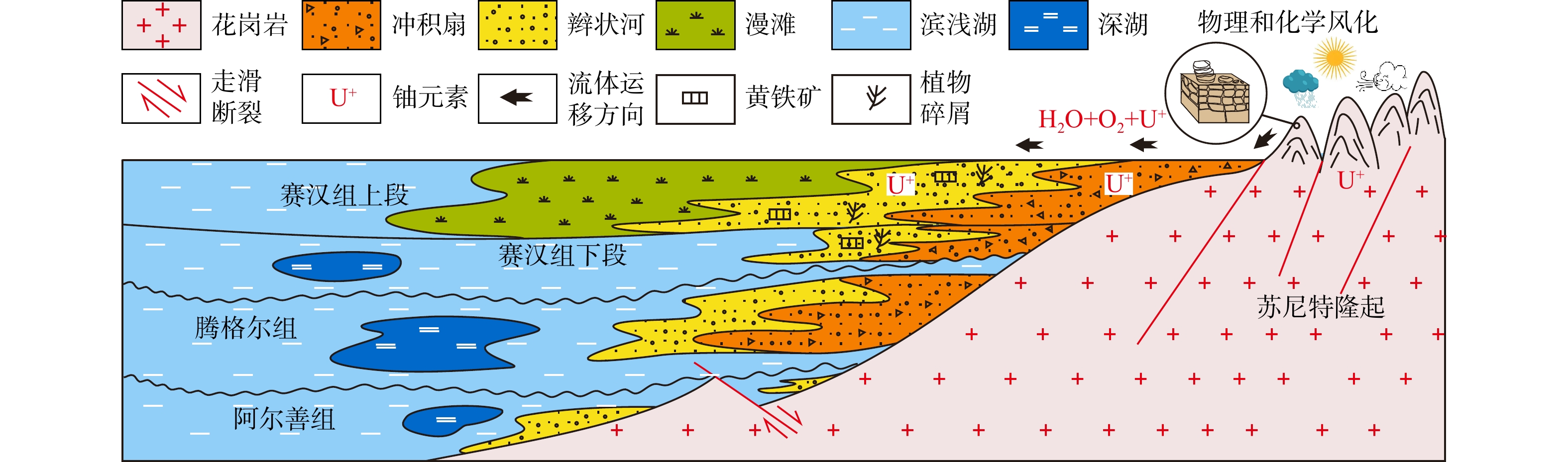
Current Issue

2025 Vol. 44, No. 6

Display Method:
2025, 44(6): 1-1. doi: 10.19509/j.cnki.dzkq.tb20250011
Abstract:
Finite discrete element method (FDEM) numerical simulation study on deterioration characteristics of soft-hard interbedded strata landslide-anti-slide pile system under wetting-drying cycles
XIAN Shuxing, YE Yang, LI Changdong, YAO Wenmin, ZHANG Huawei
2025, 44(6): 2-16. doi: 10.19509/j.cnki.dzkq.tb20230700
Abstract:
Objective

In the Zigui Basin of the Three Gorges Reservoir region, landslide-prone strata mainly composed of soft-hard interbedded strata are widely distributed. Under the long-term action of reservoir water immersion, erosion and rainfall, the formation rock and soil undergo deterioration and damage, which has become a key factor in reducing landslide stability and threatening engineering safety.

Methods

Taking rock and soil mass of soft-hard interbedded strata as the research object, finite discrete element method (FDEM) was used to calibrate the mechanical properties of hard and soft rocks in the soft-hard interbedded strata under different wetting-drying cycles. Subsequently, the mesh was redivided using an improved Voronoi diagram program, and the embedding function of zero-thickness cohesive elements was realized. An FDEM numerical model of a landslide-anti-slide pile system in soft-hard interbedded strata was proposed and established. Finally, the formation process of landslide cracks and the working mechanism of anti-slide piles under different wetting-drying cycles were studied.

Results

The results showed that: ① The number of simulated landslide cracks increased with the increase in the number of wetting-drying cycles, and the crack width also increased gradually. The simulation results were generally consistent with the field observations of the Majiagou landslide. ② The simulated cracks of the landslide-anti-slide pile system showed two evolutionary patterns: One is that the cracks spread downward from the rock mass on the top side of the pile along the pile body; the other is that the cracks gradually extended from around the anti-slide pile to the inside of the slide body, connecting with transverse cracks and vertical cracks, and finally forming large-scale through cracks. ③ With the increase in the number of wetting-drying cycles, the horizontal displacement, bending moment and shear force of anti-slide pile also increased. ④ The cracks in the soft-hard interbedded strata bedrock of the anti-slide pile showed localized development characteristics; as the number of wetting-drying cycles increased, the stress in the region gradually decreased, the displacement and strain gradually increased, and the corresponding cracks became increasingly dense.

Conclusion

The results of this study can provide support for the prevention and control of landslide in soft-hard interbedded strata under different wetting-drying cycles.

Pressure distribution characteristics and overpressure genesis of the Oligocene Linhe Formation in the Xinglong structural belt, Linhe Depression of the Hetao Basin
CAO Qiang, ZHANG Yuehui, LIU Gensheng, CHEN Shuguang, HUANG Chuanyan, LIU Jing, ZHOU Xiandi, SONG Yu, SHI Yongxi
2025, 44(6): 17-34. doi: 10.19509/j.cnki.dzkq.tb20250190
Abstract:
Objective

Drilling data are sparse in the trough area of the Xinglong structural belt within the Linhe Depression of the Hetao Basin, and the distribution pattern and evolution mechanism of the pressure system remain unclear.

Methods

Integrating data from drilling, logging, seismic, and related tests with geophysical methods and geological context, this study conducts a comprehensive analysis of the pressure distribution, genetic, mechanism, preservation conditions, and evolution history of the Linhe Formation in the Xinglong Tectonic Belt of the Linhe Depression in the Hetao Basin. The analysis employs basin-scale numerical simulation, fluid inclusion analysis, and testing techniques.

Results

The results indicate that the Linhe Formation's pressure distribution in the study area follows a "high in the north and low in the south, high in the west and low in the east" pattern. Among them, the source rock strata of the Linhe Formation exhibit pronounced lateral zonation: The inner zone and trough area-middle zone-outer zone presenting extremely strong overpressure/strong overpressure-weak overpressure-normal pressure. The reservoirs of the Linhe Formation develop overpressure only in the inner zone and trough area, while most other areas exhibit normal pressure. Longitudinally, the overpressure top interface generally lies within the Wuyuan Formation. From top to bottom, overpressure in the Wuyuan Formation (with thick-bedded mudstone) is mainly caused by undercompacted. Hydrocarbon generation pressurization dominates overpressure formation in the Linhe Formation's source rocks, and the principal cause of overpressure in the Linhe Formation reservoirs is pressure transmission. The overpressure of the Linhe Formation formed during the rapid burial of the Wuyuan Formation (5.3 Ma), driven by the dual control mechanism of source rock thermal evolution and undercompaction-hydrocarbon generation pressurization, resulting in weak overpressure. Overpressure intensification occurred during the Quaternary (approximately 2.6 Ma), with inner-belt reservoir pressures increasing to strong overpressure through pressure transfer. However, overpressure was not preserved in other areas due to strike-slip tectonic adjustment, resulting in normal pressure.

Conclusions

This study clarifies the hydrocarba accumulation dynamics conditions of the Linhe Depression and guides subsequent oil and gas exploration and development.

Genesis of uranium reservoirs in the Upper Cretaceous Saihan Formation in the central Ulanqab Depression of the Erlian Basin and their constraints on uranium mineralization
LIU Yang, LUO Ning, LI Jianmin, YU Xiaolin, HE Shaowei
2025, 44(6): 35-49. doi: 10.19509/j.cnki.dzkq.tb20250202
Abstract:
Objective

The uranium reservoir is the foundation of sandstone-type uranium mineralization. Therefore, studying the genesis of uranium reservoirs is essential for understanding uranium mineralization processes and evaluating uranium mineralization potential.

Methods

This paper conducts a genetic analysis of the uranium reservoir in the Saihan Formation in the central part of the Ulanqab Depression in the Erlian Basin based on analyses of the sand dispersal system, detrital components of sediments, heavy mineral assemblages, and elemental composition.
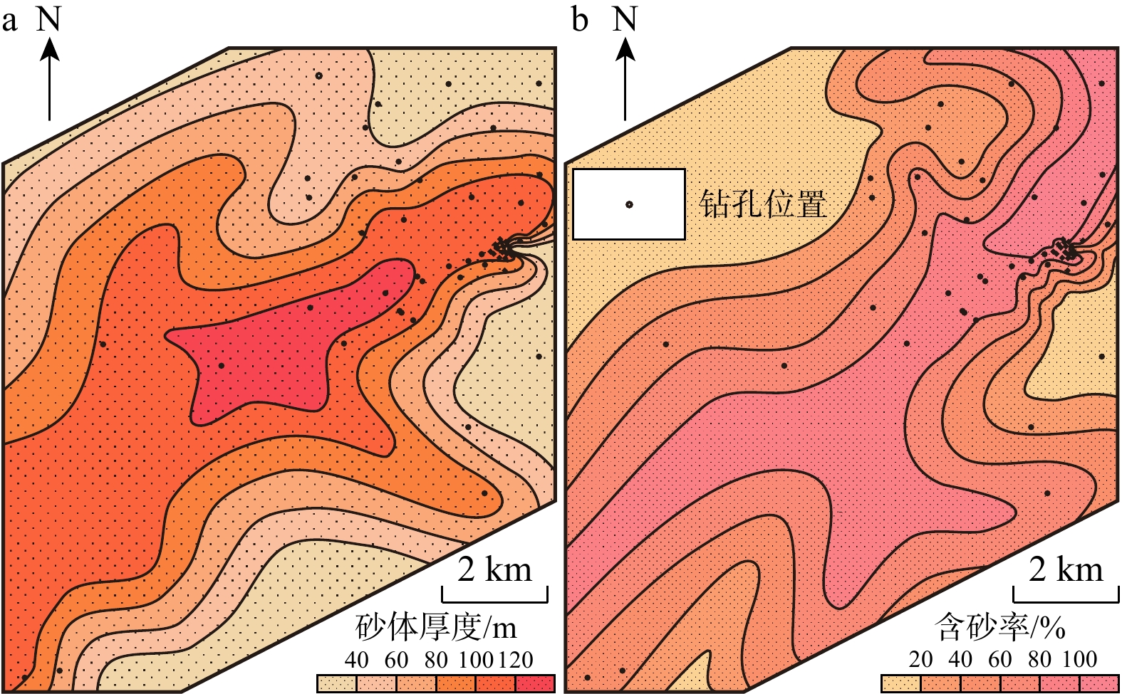
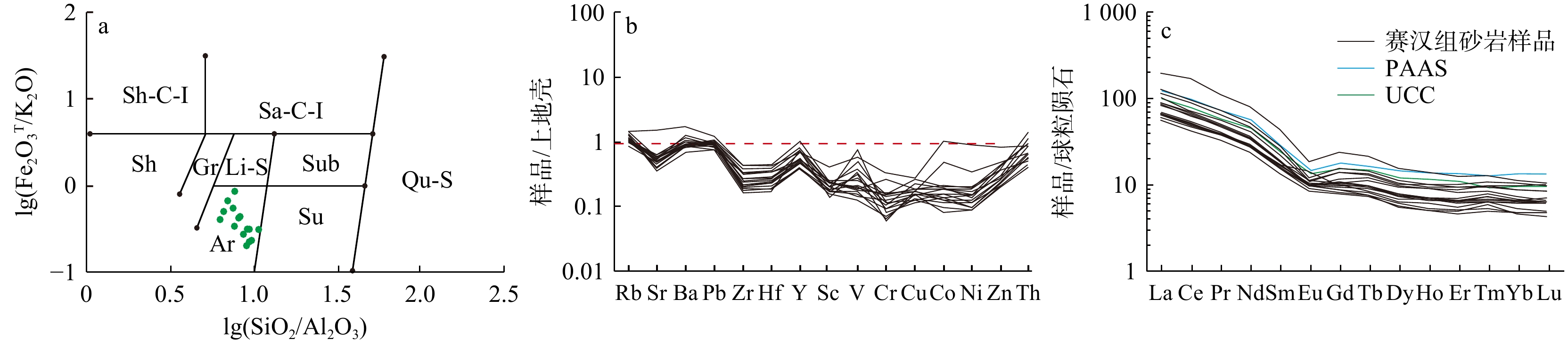
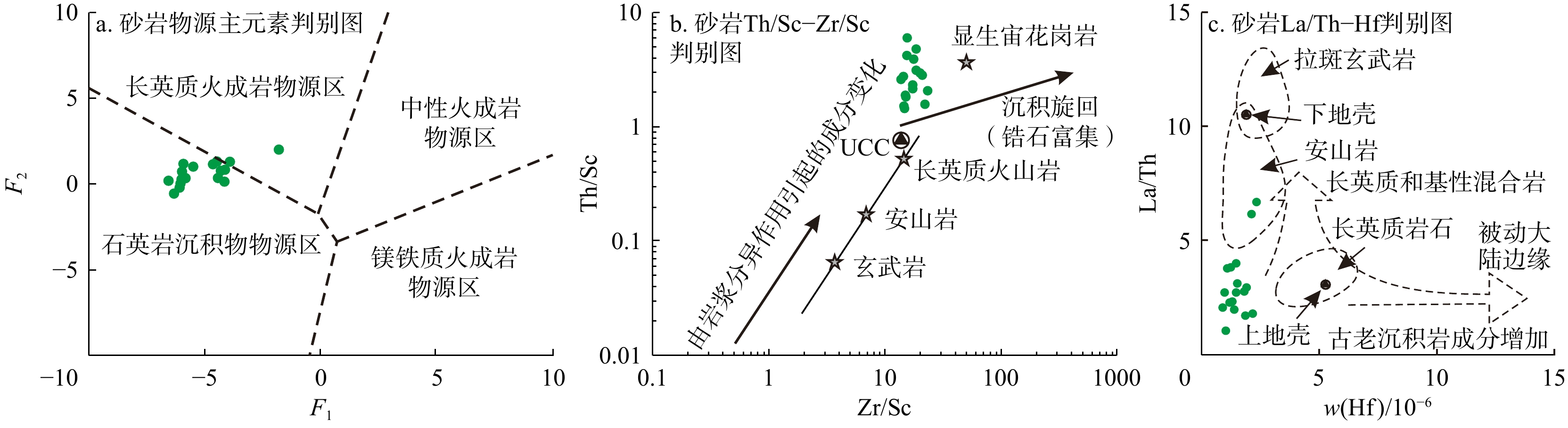
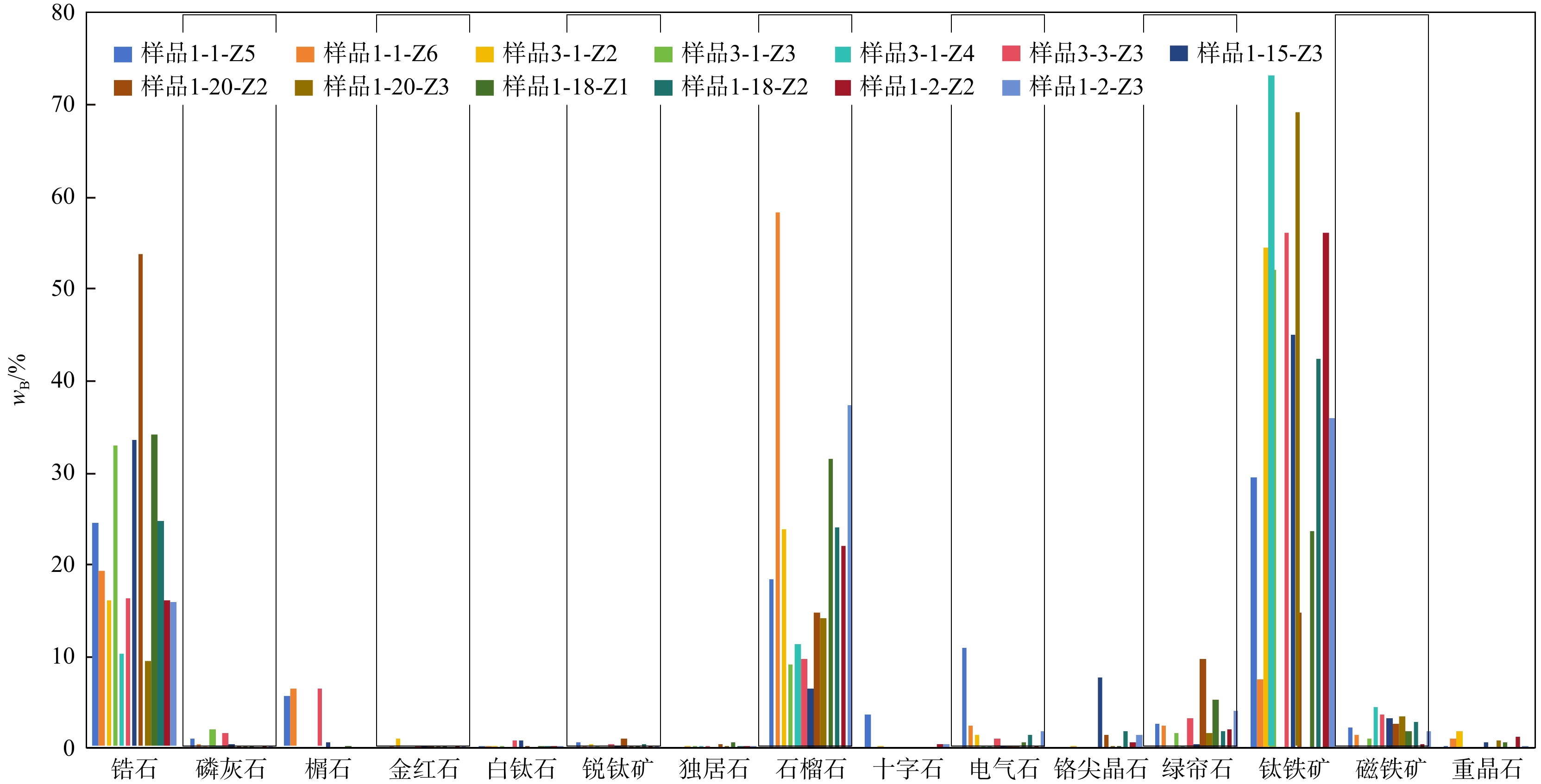
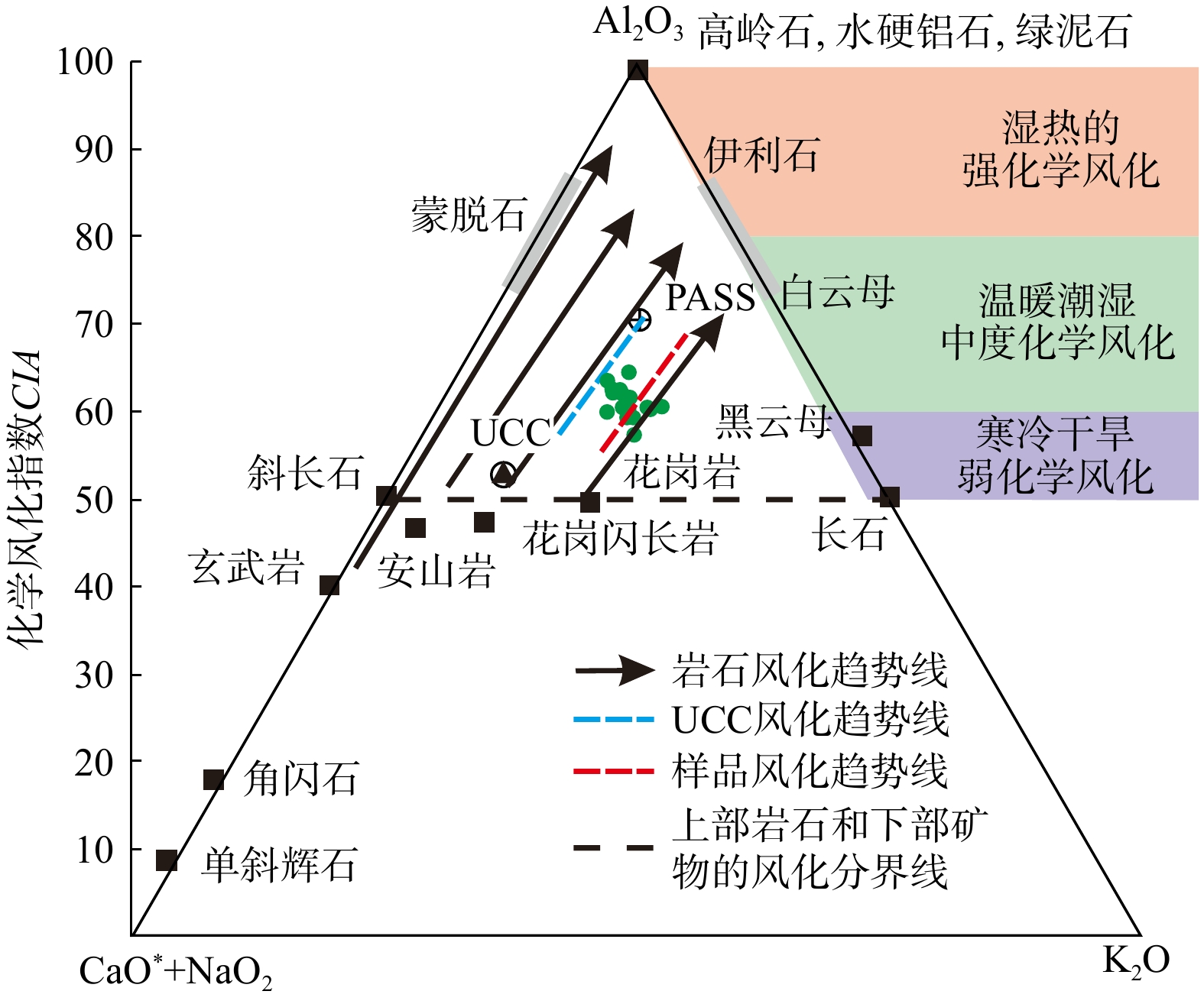
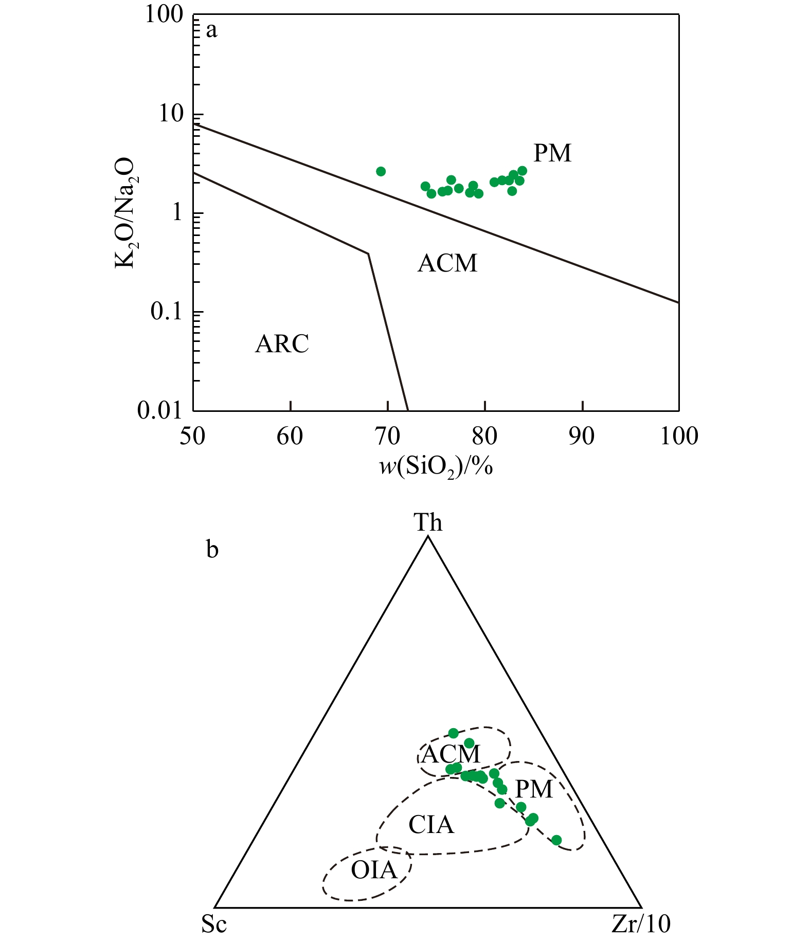
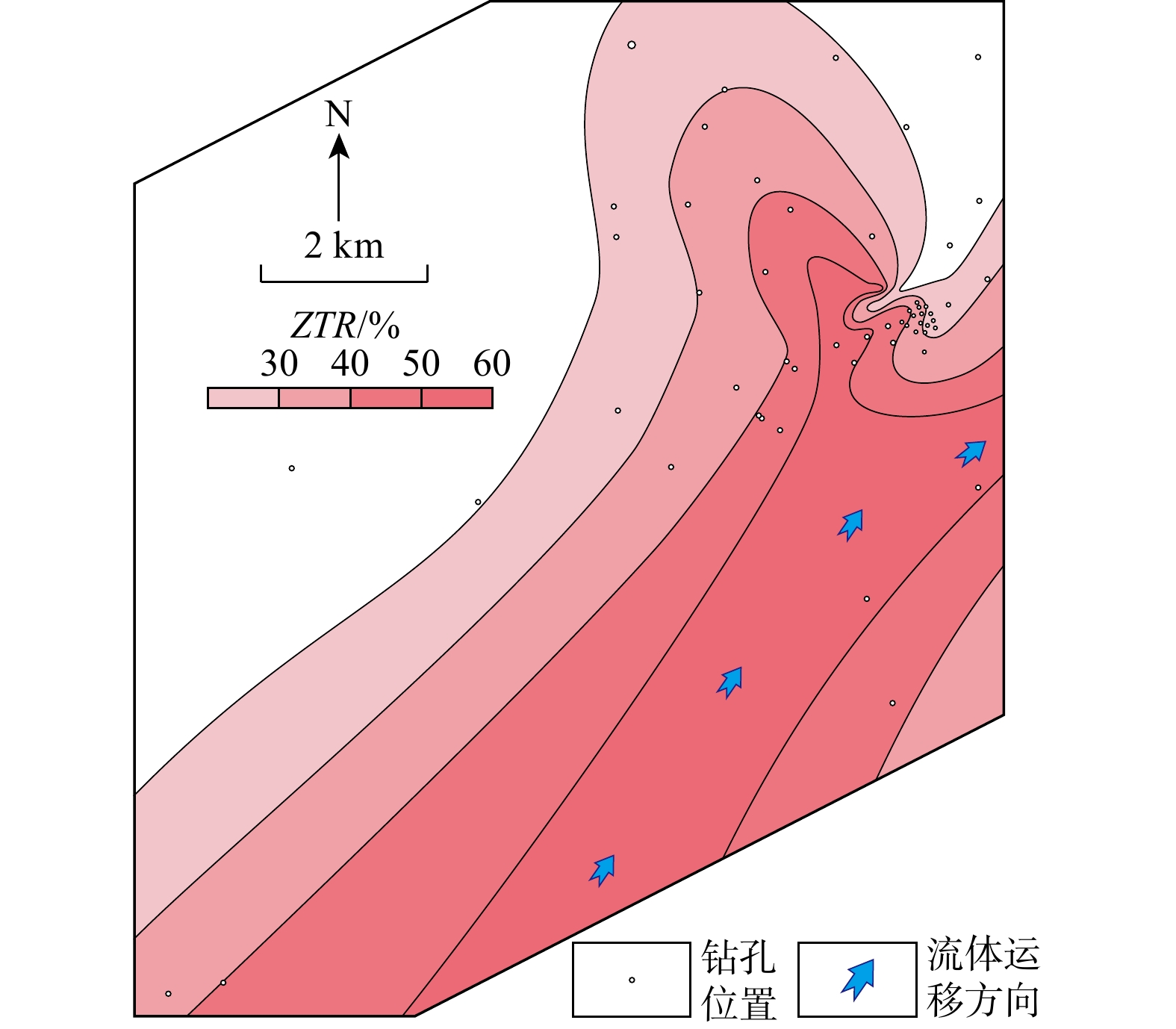
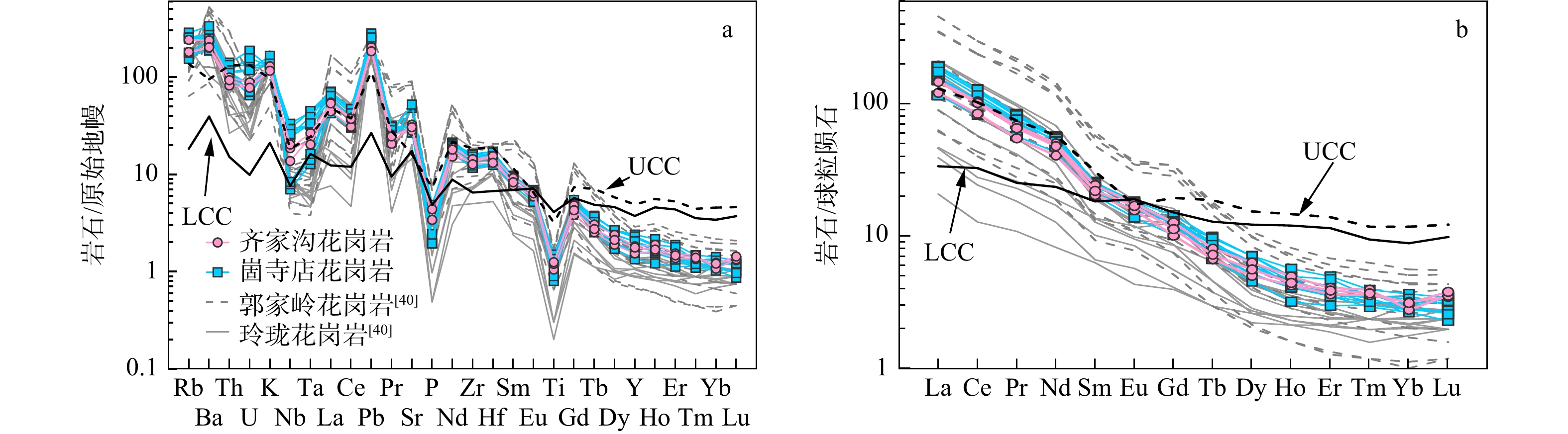
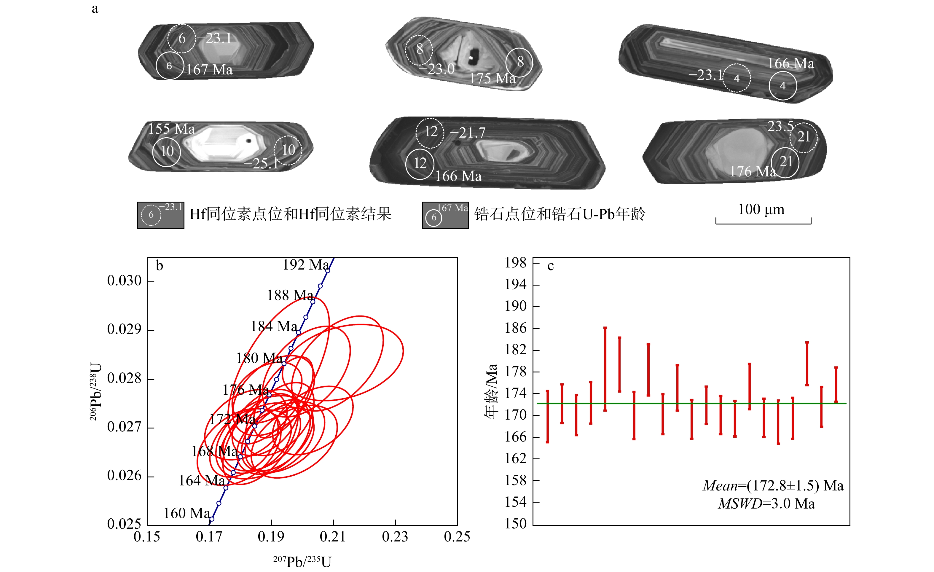
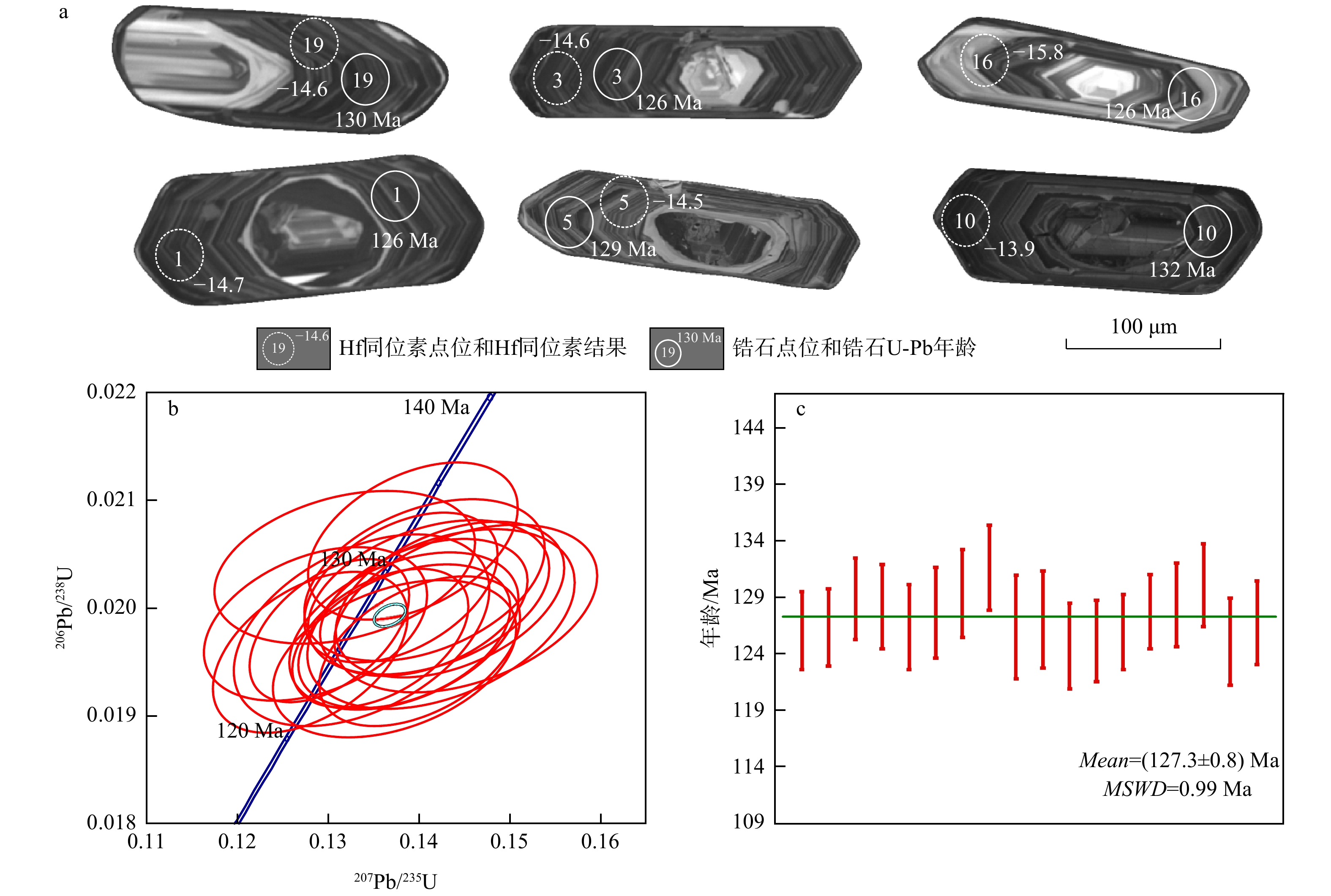
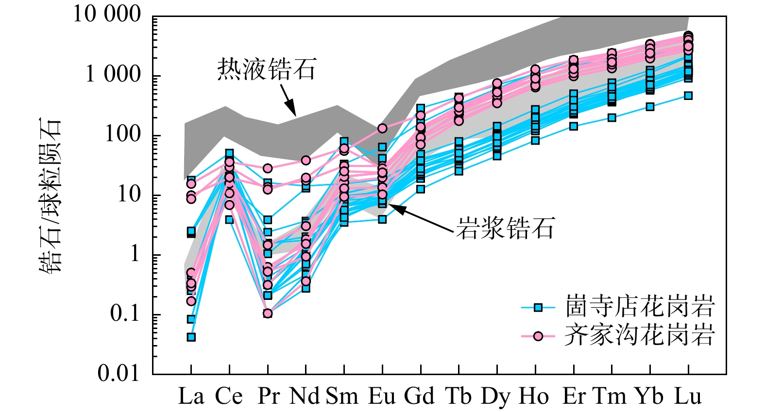
Results

The study found that the average contents of quartz, feldspar, and rock fragments in the sandstone are 51%, 27%, and 12%, respectively. The average values of Fe2O3T/K2O and SiO2/Al2O3 are 0.12 and 8.61, respectively, with an average CIA value of 61.83. The average Eu/Eu* value is 0.75. A total of 23 major heavy minerals were identified in the sandstone, with average ATi and ZGi values of 35.2 and 48.8, respectively, and ZTR values ranging between 24.2% and 71.6%.
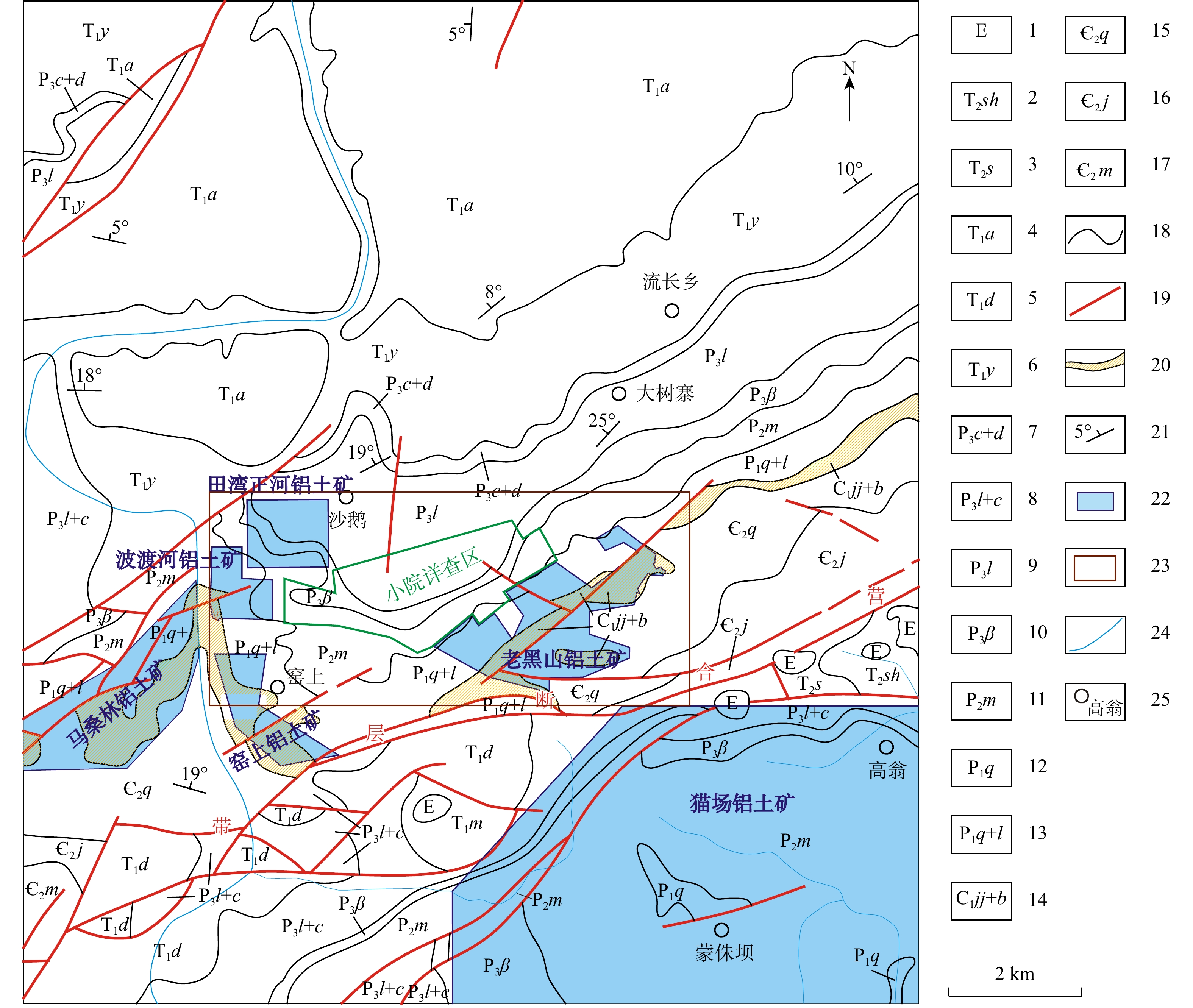
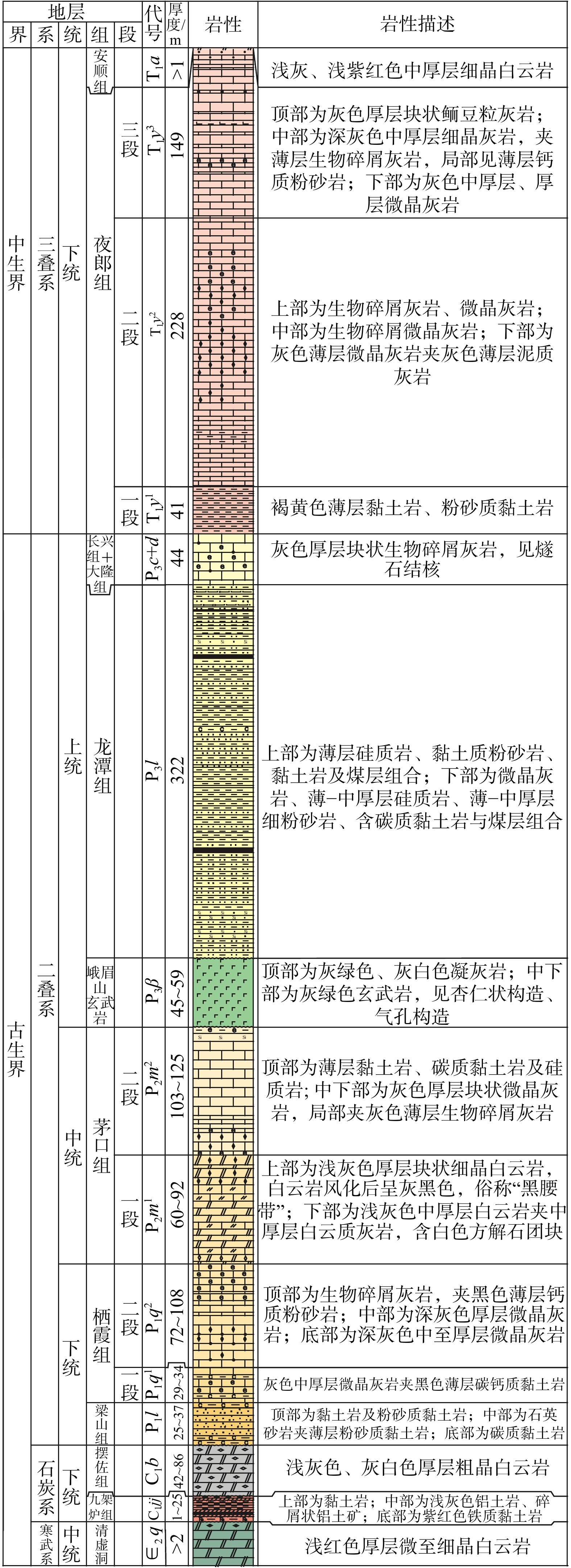
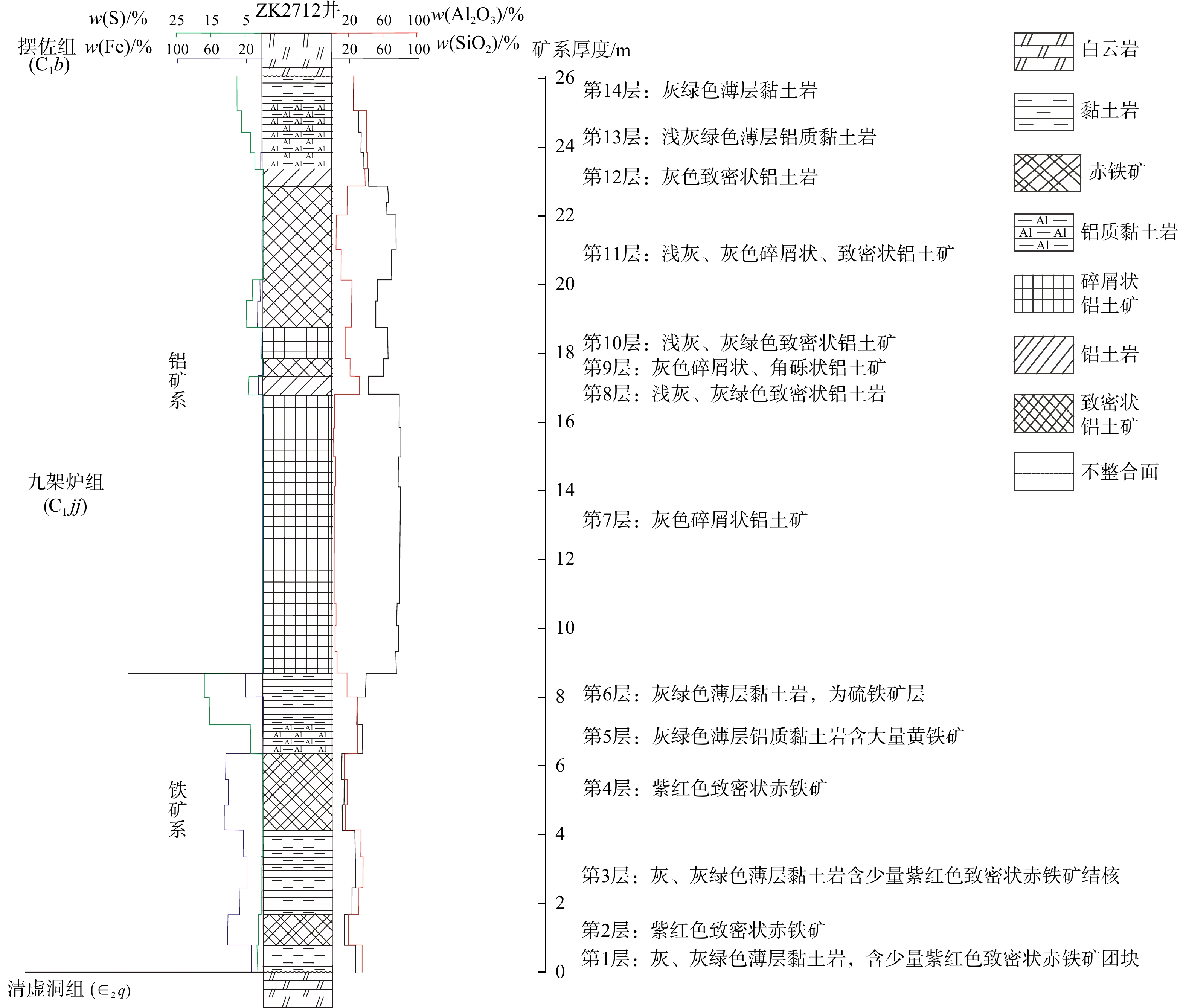
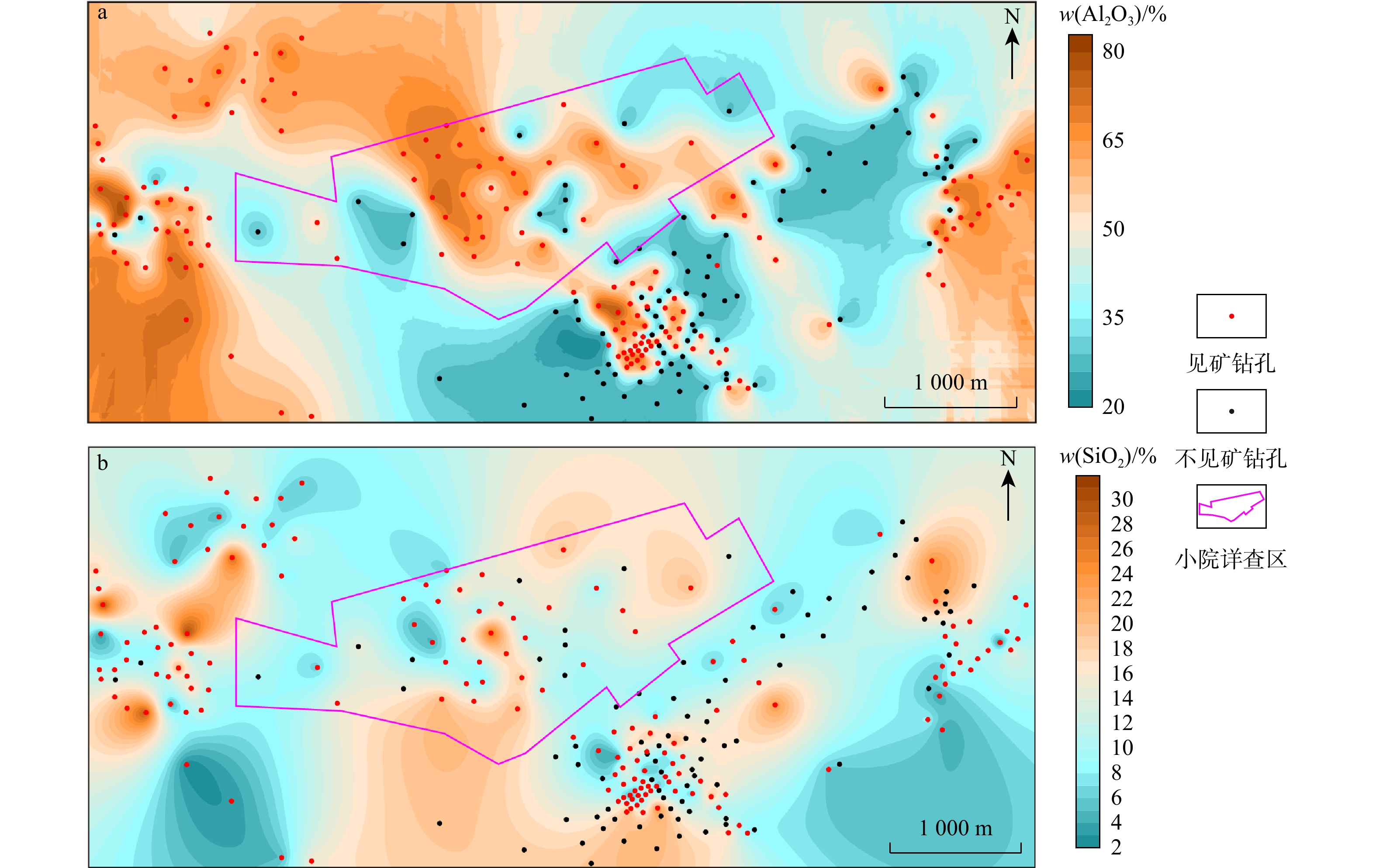
Conclusions

These characteristics indicate that the sandstone types in the Saihan Formation are feldspathic sandstone and lithic sandstone, with the parent rocks primarily composed of intermediate-acidic magmatic rocks. The chemical weathering intensity of the parent rocks in the source area is moderate, reflecting strong chemical weathering under warm and humid conditions. The tectonic setting of the parent rocks in the source area is mainly continental margin, with the provenance primarily derived from the Sonid Uplift. Based on comprehensive analysis, it is concluded that during the Permian-Triassic and Jurassic-Cretaceous periods, intermediate-acidic granites formed in the Sonid uplift under a continental margin tectonic setting. Under warm and humid climatic conditions, these rocks underwent intense weathering, and the resulting detrital materials were transported by fluids into the basin, forming the uranium-bearing sandstone of the Upper Saihan Formation. Through subsequent uranium mineralization processes, the uranium was enriched and formed sandstone-type uranium deposits.

Geological characteristics, paleolandforms, and their relationship with bauxite distribution in the Xiaoyuan bauxite mine, Qingzhen City, Guizhou Province
CAI Lu, TANG Long, ZHOU Dongdong, LIANG Peng, GAO Shuang, WEN Guojiang, YANG Mingkun, DONG Yanjie
2025, 44(6): 50-60. doi: 10.19509/j.cnki.dzkq.tb20240016
Abstract:
<p>Ancient karst landforms play a key role in controlling the shape and scale of bauxite deposits, which is of great significance for the planning of engineering layouts in mineral exploration. </p></sec><sec><title>Objective

This study aims to analyze the impact of ancient landforms in Xiaoyuan area on the distribution of bauxite deposits.

Methods

This paper utilizes drilling and testing data from Xiaoyuan bauxite mining area, and employs the thickness of the Paizuo Formation and Jiujialu Formation (C1b+jj) and the thickness of the Paizuo Formation (C1b) to reconstruct the paleogeomorphic features of the Jiujialu Formation before and after sedimentation.

Results

The results show that the bauxite ore bodies are distributed intermittently along the direction of decreasing paleolandform elevation, and the morphology of individual ore bodies is controlled by specific geomorphic features such as depressions and sinkholes. Along the descending gradient of ancient landforms, locally low-lying areas are favorable sites for the formation of bauxite deposits. Two prospective bauxite mining target areas (Chayuan and Shizi) were predicted.

Conclusion

The research results provide a reference for the exploration of bauxite resources.

Occurrence of cobalt and its geological significance in the Qibaoshan Co-Pb-Zn deposit, central segment of the Jiangnan orogenic belt
KUANG Erlong, CHEN Zhikang, ZHOU Jiangtao, LI Guomeng, JIANG Baoliang, LUO Xicheng, LI Yanjun
2025, 44(6): 61-76. doi: 10.19509/j.cnki.dzkq.tb20240410
Abstract:
Objective

Cobalt is an important strategic metal, crucial for new energy technologies. Understanding its occurrence in ore deposits represents a key focus of international ore deposit research. The Qibaoshan Co-Pb-Zn deposit, located in the central segment of the Jiangnan orogenic belt, features ore bodies controlled by secondary folds within the core of the Gaodongshan anticline, which exhibit NE-trending lenticular or stratoid shapes. However, the occurrence state of cobalt in this deposit remains poorly constrained.

Methods

In this study, ore samples collected from different levels of the open pit were analyzed using backscattered electronc (BSE) imaging, energy dispersive X-ray spectroscopy (EDS), and electron probe microanalysis (EPMA).

Results

The results show that cobalt occurs predominantly as independent minerals, including safflorite, cobaltite, skutterudite, and siegenite. Minor cobalt is hosted in solid solution within fine-grained pyrite and rammelsbergite. Rammelsbergite commonly exhibits mantles replaced by safflorite, and both minerals are in turn replaced at their rims by cobaltite and gersdorffite. Cobaltite and Cu-bearing siegenite also frequently replace the margins of chalcopyrite. These mineralogical relationships indicate that the early-stage ore-forming fluids were characterized by high arsenic activity, leading to the precipitation of rammelsbergite, safflorite, and skutterudite. As mineralization proceeded, arsenic activity decreased while sulfur activity increased, resulting in the formation of cobaltite and siegenite during the late stage.

Conclusions

The replacement textures and mineral assemblages of Co-Ni minerals in the Qibaoshan deposit resemble those typical of "five-element vein"-type deposits. Therefore, the Qibaoshan deposit is classified as a hydrothermal vein-type Co-Pb-Zn deposit with characteristics of "five-element vein".

Geochemistry, zircon U-Pb age and Lu-Hf isotopic characteristics of Mesozoic granites in Daliuhang, Jiaodong area and their tectonic significance
ZHAO Zhihua, SHAO Yubao, JI Xubo, WANG Jiangbo, HUANG Xinglong, WANG Yongjun, WANG Peng, QI Shufa, CUI Yufeng, HUANG Xin, LU Changyong, SONG Yu, LI Xiuzhang
2025, 44(6): 77-95. doi: 10.19509/j.cnki.dzkq.tb20230693
Abstract:
Objective

To determine the rock type, age and tectonic setting of Mesozoic granites in Daliuhang, Jiaodong area, and to explore the relationship between the granite and gold mineralization,

Methods

the Mesozoic Yanshanian Linglong-type granites (Qijiagou monzonitic granite) and Guojialing-type granites (Gusidian monzonitic granite), which were located in the north of Qixia-Penglai gold metallogenic belt in eastern Jiaodong area, are selected to analyze whole-rock geochemistry, U-Pb dating and Lu-Hf isotope of zircon.

Results

The results show that the U-Pb age of the zircon from Qijiagou monzonite is (172.8±1.5) Ma, with the εHf(t) values of the zircon ranging from −27.7 to −20.3. The zircon U-Pb age of Gusidian monzonitic granite is (127.3±0.8) Ma, with the εHf(t) values of zircon ranging from −15.7 to −13.4. The 87Sr/86Sr ratio of Gusidian monzonitic granite is 0.7107040.711223, with the εNd (t) values ranging from −16.8 to −11.3.

Conclusions

The Qijiagou monzonitic granite is derived from the ancient lower crust, which is mainly from the North China Craton lower crust. The magma source of Qijiagou monzonitic granite may be mixed with the Yangtze Craton crust. The Gusidian monzonitic granite forms by partial melting of mafic rocks of lower crust, with mantle components added in the process. The diagenetic tectonic background was extensional, which may be caused by the subduction and retreatment of the Pacific plate. The Gusidian monzonitic granites have high coordination with the characteristics of Early Cretaceous gold mineralization in Jiaodong area, suggesting a genetic link between this granite and local gold mineralization in this area.

Quantitative evaluation of hydrocarbon generation, expulsion, and retention potential in deep Permian Wujiaping Formation shale gas reservoir, southeastern Sichuan Basin
WANG Huijun, YANG Rui, SHU Zhiguo, DENG Mo, LIU Jiyong, HE Taohua
2025, 44(6): 96-109. doi: 10.19509/j.cnki.dzkq.tb20250224
Abstract:
Objective

Quantitative characterization of hydrocarbon generation, expulsion, and retention intensity in high to over-mature shale gas reservoirs remains a critical challenge for deep resource evaluation. The Permian Wujiaping Formation (Wu Second Member) shale gas reservoir in the Hongxing area of the southeastern Sichuan Basin (with proven reserves exceeding 1011 m3) exhibits thin-layer distribution, strong heterogeneity, and multi-stage tectonic modification. These characteristics complicate precise reconstruction of the spatiotemporal evolution of generation-expulsion-retention processes using traditional evaluation methods.

Methods

This study established a multi-dimensional evaluation framework that integrates thermal simulation experiments, hydrocarbon potential methods, and generation kinetic modeling with mutual verification. This framework systematically reconstructs the complete evolutionary model of the Wu Second Member shale gas reservoir from generation to preservation, enabling quantitative characterization and spatial prediction of resource potential.

Results

Thermal simulation results show a total hydrocarbon generation rate of 456 mg/g, comprising total gas generation of 349.68 mg/g (76.7%) and total oil generation of 106.59 mg/g (23.3%); oil-phase products were primarily expelled (103.35 mg/g) with limited retention (3.24 mg/g). Hydrocarbon potential evaluation indicates that the Wu Second Member shale entered the hydrocarbon generation threshold at Ro=0.5% and the expulsion threshold at Ro=0.8%, with an original hydrocarbon generation potential index reaching 550 mg/g. Present-day generation, expulsion, and retention intensities in the Hongxing area and surrounding regions reached maximum values of 90×108, 68×108, 28×108 m3/km2, respectively, with their centers highly spatially coupled in three key areas: Wanzhou-Hongxing-Enshi. Generation-kinetics modeling indicates that peak gas-generation intensity in the study area can reach 50 × 108 m3/km2, with a maximum gas-retention intensity of 16 × 108 m3/km2. Through a comprehensive analysis of crucial preservation factors (burial depth, structural stability, and sealing capacity), we quantitatively determine the present-day residual-gas intensity distribution, identifying the Hongxing-Wanzhou region as the optimal exploration target.

Conclusion

This study not only elucidates the spatiotemporal evolution patterns of hydrocarbon generation, expulsion, and retention in the Permian shale gas reservoir of the Sichuan Basin but also provides a theoretical foundation and practical guidance for the refined exploration of deep to ultra-deep shale gas reservoirs.

Numerical simulation on heat exchange performance of coaxical borehole heat exchanger
LI Peng, LI Hangzhe, YANG Chao, FANG Yuan, DUAN Xinsheng, SU Pengwei, MA Di
2025, 44(6): 110-120. doi: 10.19509/j.cnki.dzkq.tb20240032
Abstract:
Objective

Shallow geothermal energy is a clean and stable renewable energy source. Ground-coupled heat pumps represents are a commonly used technology for developing and utilizing shallow geothermal energy in building heating and cooling systems. This technology extracts heat from the subsurface without pumping groundwater; thus causing minimal disturbance to the underground environment. The borehole heat exchanger serves as the primary component of heat exchange in ground-coupled heat pump systems, with the U-shaped configuration being the most prevalent. However, research and application of coaxial borehole heat exchangers in shallow geothermal energy remain relatively limited.

Methods

This study focuses on the shallow coaxial borehole heat exchanger and conducts numerical simulations to investigate their heat exchange performance, analyze sensitivity factors, and compare their efficiency with that of a U-shaped borehole heat exchanger.

Results

The findings demonstrate that when traditional PE pipes are employed for both the inner and outer pipes of a coaxial borehole heat exchanger, thermal short-circuiting occurs between the annular fluid and the inner pipe fluid, resulting in a 23% reduction in heat exchange efficiency. The sensitivity factors influencing coaxial borehole heat exchangers performance are ranked as follows: Inlet temperature, initial soil temperature, circulating flow rate, thermal conductivity of casing and inner pipe materials, and thermal conductivity of backfill material. Under identical conditions, the U-shaped borehole heat exchanger exhibits an 8.57% higher heat exchange efficiency compared to coaxial borehole heat exchanges. However, when a coaxial borehole heat exchanger's casing is constructed from steel and its inner pipe is insulated, its heat exchange efficiency exceeds that of the U-shaped borehole heat exchanger by 21.64%.

Conclusion

The research results can provide a reference for the research and application of shallow-buried pipe technology.

Discussion on the spatiotemporal differences of Cenozoic rift formation and evolution and its genetic mechanism in the Pearl River Mouth Basin
JI Kai, DENG Chao, LI Bo, WU Ke, ZHOU Liang, CAO Binfeng, WU Yuxiang
2025, 44(6): 121-133. doi: 10.19509/j.cnki.dzkq.tb20240054
Abstract:
Objective

To deepen the understanding of spatial and temporal differences in rift formation and evolution among different tectonic units within the Pearl River Mouth Basin.

Methods

Based on 2D seismic profile data, this study analyzes differences in pre-existing structures, basement lithology, fracture systems, and tectonic evolution across tectonic units using tectonic analysis, balanced cross-section restoration, and fracture activity rate calculation, combined with magmatic activities and dynamics background, the causes of depression tectonics in the basin are explored.

Results

A series of NE-trending thrust faults and conjugate NW-trending pre-existing thrust faults developed on the basement tectonics of the Pearl River Mouth Basin. NE-NEE -trending faults dominate in the western parts of the Zhu Ⅲ, Zhu Ⅱ, and Zhu Ⅰ depressions, while near-EW- to NWW-trending faults dominate in the eastern Zhu Ⅰ and Zhu Ⅱ depressions, controlling the basin's tectonic pattern during the rifting period. Rifting intensity weakens from east to west, and the eastern part of Zhu Ⅰ Depression exhibits higher fault activity.

Conclusions

During rifting, major faults during the rifting period inherited and developed along pre-existing basement faults. The main fault system within the same sedimentary trunk in the Zhu Ⅰ and Zhu Ⅱ depressions evolved clockwise from NW-NEE-trending to EW-NW-trending and strike-slip dominated, with tensile and shear strengths modulated by differences in basement structure and lithology, and influenced by surrounding plate movement, magmatic activities, and regional stress field changes. In the late stage, the rift architecture transitions from a narrow elongated graben/half-graben "thick lower part and thin upper part" in the north to a broad, gentle graben/half-graben with "thick upper part and thin lower part" in the south.

Continuous probability threshold for rainfall-type landslides in Zigui County, Hubei Province
LI Yuanyao, WANG Zhehan, JU Le, LI Ming, ZHANG Peng
2025, 44(6): 134-146. doi: 10.19509/j.cnki.dzkq.tb20250352
Abstract:
<p>Determining rainfall thresholds is a crucial foundation for landslide hazard assessments and meteorological risk early warnings. </p></sec><sec><title>Objective

To address the limitations of low spatial resolution and poor accuracy in distinguishing rainfall processes of traditional critical rainfall thresholds,

Methods

this study takes Zigui County, Hubei Province as a case. Based on data from 472 landslides and 58 rainfall stations, an effective rainfall-duration (E-D) critical rainfall threshold was established; logistic regression was employed, with effective rainfall (E) and duration (D) as the independent variables and time probability (P) as the dependent variable, to fit the continuous probability thresholds for rainfall-induced landslides within the study area; finally, the accuracy of the threshold model was analyzed and validated from both temporal and spatial perspectives using historical landslide events and hazard assessment results.

Results

The results indicate: ① Landslides in the region are primarily small to medium-sized shallow-deposited layer landslides, with a significant positive correlation between rainfall and landslides occurrences, with 86.63% of landslides occurring during the rainy season; ②The nonlinear fitting equation for the continuous probability threshold is $ 1/P=1+{{\mathrm{e}}}^{2.0792+0.24156\times D-0.04072\times E} $, with a fitting degree of 0.9497; ③ Using validation set of landslide samples, when the probability of landslide occurrence reaches 60%, the prediction accuracy of the continuous probability threshold model improves by 17.4%, and the hazard levels of four known landslides in the hazard assessment all increase.

Conclusion

The continuous probability threshold demonstrates superior accuracy in landslide disaster warning and spatial resolution for the study area, providing a scientific theoretical reference for local governments to conduct landslide risk warnings.

Determination of the 3D most dangerous sliding surface for open-pit mine slopes based on multiple cross-profiles
CHEN Yingxian, YE Yongchao, YANG Hongxia, LI Jiaying
2025, 44(6): 147-156. doi: 10.19509/j.cnki.dzkq.tb20230690
Abstract:
<p>At present, the two-dimensional (2D) profiles are widely used for slope stability analysis, which has proved to be efficient and relatively accurate. </p></sec><sec><title>Objective

However, the two-dimensional profile cannot describe the 3D spatial morphology of the most dangerous sliding surface sliding mass.

Methods and Results

To address the limitation, based on the stability analysis of the two-dimensional profile slope, the three-dimensional most dangerous sliding surface of the slope is fitted using the spline function by associating multiple profiles with the three-dimensional slope model. Firstly, the relationship between the two-dimensional profile and the three-dimensional slope space is established by setting the profile name, horizontal coordinate positioning and elevation positioning of the graphic elements in the profile line and the two-dimensional profile. Secondly, the most dangerous sliding surface lines of each profile are automatically generated by using the multi-profile resultant force method, and the most dangerous sliding surface lines of each two-dimensional profile are converted to three-dimensional slope space by using the coordinate transformation formula. Finally, the spline function interpolation is used to fit the most dangerous sliding surface lines in the three-dimensional space to construct the three-dimensional most dangerous sliding surface. Taking the southwest slope of an open-pit mine in Xilinhot, Inner Mongolia as an example, a three-dimensional engineering geological model of the slope is established, and five two-dimensional profiles for slope stability analysis are generated. Through this method, the three-dimensional most dangerous sliding surface and three-dimensional sliding mass are successfully generated and their rationality is verified.

Conclusion

The research results provide new insights for predicting the location, scale, and damage degree of potential slope sliding masses.

Research on the I-D-M threshold model for regional rainfall-induced landslide hazard early warning at a regional scale
LU Cao, YAN Echuan, CHEN Xiating, FANG Hailun, XU Yi, TAO Qinghua
2025, 44(6): 157-165. doi: 10.19509/j.cnki.dzkq.tb20250216
Abstract:
Objective

Regional early warning of rainfall-induced landslide has been a research hotpot in recent years, with the primary challenge being the formulation of rainfall threshold models. Based on hourly rainfall data, this study introduces peak rainfall (M) to construct a three-dimensional characterization model, which can provide a scientific basis for regional rainfall-induced landslide early warning.

Methods

The research was conducted using data from 104 rainfall-induced landslide events recorded between 2010 and 2022 in the three northern districts of Ningbo City (Cixi, Jiangbei, and Zhenhai). Firstly, the spatial distribution of rainfall stations associated with landslides was delineated using Voronoi diagram method to reveal the effective rainfall characteristic information of landslide hazards. Secondly, the rainfall intensity-rainfall duration (I-D) threshold model was established based on landslide inventory, with critical threshold curves defined using quantile regression. Finally, to address the limitations of the I-D model, peak rainfall (M) was incorporated to propose an improved I-D-M model. The accuracy of both models was evaluated and compared using ROC curves and historical landslide cases to identify the optimal threshold model for regional early warning.

Results

The results demonstrate that the I-D-M model, incorporating peak rainfall (M), achieves higher warning accuracy than the conventional I-D model. Probability of landslide occurrence increased by 8% for yellow warnings, 17% for orange warnings, and 16% for red warnings, indicating the significant role of peak rainfall on landslide initiation. The quantile regression-based I-D-M threshold model can be effectively applied as a criterion for implementing three-tiered (red, orange, yellow) rainfall landslide early warning in the study area.

Conclusion

The proposed three-dimensional rainfall threshold model provides theoretical and practical insights for improving regional landslide early warning systems, demonstrating enhanced predictive capability and operational applicability.

Evolution characteristics of layered subsidence in Hengshui City and its response mechanism to environmental factors
WANG Qin, GONG Huili, TIAN Yu, CHEN Beibei, ZHOU Chaofan, ZHU Lin
2025, 44(6): 166-177. doi: 10.19509/j.cnki.dzkq.tb20240022
Abstract:
Objective

Affected by climate change and human activities, groundwater resources in the Hengshui area have been over exploited year-round, which directly leads to severe ground subsidence, becoming one of the main geological disasters in this region.

Methods

Based on the accumulated settlement data of the main urban area of Hengshui City from January 2009 to December 2022, obtained from layered mark monitoring, this study investigates the ground subsidence mechanism of three compression layers (F1, F2, F3 layers from shallow to deep). First, the Gompertz model was used to fit the cumulative settlement of each compression layer. The first-order derivative of the fitting results was then calculated to determine the settlement rate of each layer. With 0.5 mm/month as the threshold, the periods of settlement initiation, rapid settlement rate growth, gradual settlement rate decline, and settlement stabilization of each layer are identified. The zero growth (ZG) model is then employed to divide the settlement of each layer into irreversible settlement sequence (GRC) and reversible rebound sequence (SWD), and the fluctuation characteristics of settlement and rebound periods are analyzed. Finally, the linear mixed model (LMM) is applied to analyze the contribution of environmental factors such as precipitation, evapotranspiration, shallow groundwater level, and deep groundwater level to the compression settlement (GRC_rate) during each layer's settlement period.

Results

The results show that: ①The cumulative settlement fitting curves of each layers all exhibit an "S" shape, and the settlement rate curves show a single-peak pattern, with a "slow-fast-slow" trend. The main settlement period start time, end time, cumulative settlement, and settlement rate of each layer differ; ② In terms of cumulative settlement and monthly settlement increment amplitude, F3 layer > F2 layer > F1 layer. In terms of rebound amplitude, F1 layer > F2 and F3 layers; ③ Evapotranspiration and shallow groundwater level contribute the most to the compression settlement of F1 and F2 layers, while shallow groundwater level and deep groundwater level are the primary contributors to the compression settlement of F3 layer.

Conclusion

The research results provide a reference for the prevention and control of land subsidence.

Mesoscopic failure evolution of mud shale based on CT-PFC coupling method
ZANG Xin, BIAN Huiyuan, ZHANG Yonghao, WANG Fei, ZHAO Jianbin, FANG Chaoqiang
2025, 44(6): 178-188. doi: 10.19509/j.cnki.dzkq.tb20230724
Abstract:
Objective

To investigate the failure mechanism of rocks at the mesoscopic scale,

Methods

this study proposes a novel modeling method that combines digital image processing (DIP) technology and particle flow code (PFC) to characterize mineral properties. The discrete element numerical model was calibrated using macroscopic mechanical parameters and failure modes obtained from conventional triaxial compression tests. Under geostress conditions, the influence of rock mineral properties on rock failure evolution and the effect of heterogeneous structures on microcracking behavior were analyzed.

Results

The results show that the loading process of conventional triaxial compression tests can be divided into four stages: Crack closing stage, elastic deformation stage, crack growth stage, and crack explosion stage. Simulations based on computed tomography (CT) slices of three shale samples indicate that rock heterogeneity has a certain impact on the generation of rock microcracks and rock physical-mechanical parameters: Weaker heterogeneity corresponds to higher peak strength (σmax) and elastic modulus (E). In terms of crack propagation distribution, increased heterogeneity leads to a more complex microcrack distribution. From the perspective of the spatial distribution of rock microcracks, microcracks tend to occur preferentially at the interfaces between dolomite and quartz minerals.

Conclusion

The research findings provide important reference significance for deep underground oil and gas exploitation and disaster prevention engineering.

Large-scale triaxial test analysis on geocell-reinforced effect of coarse-grained soil under freeze-thaw cycles
ZHONG Bo, SONG Ling, LEI Bingbing, CHEN Jiangang, LIU Jie
2025, 44(6): 189-198. doi: 10.19509/j.cnki.dzkq.tb20240096
Abstract:
Objective

Focusing on the application of coarse-grained soil fillings in alpine mountainous regions, this study aims to analyze the reinforcing effect of geocell-reinforced coarse-grained soil under freeze-thaw cycles.

Methods

Cyclic freeze-thaw tests and large-scale triaxial unconsolidated-undrained (UU) compression tests were conducted on both geocell-reinforced and unreinforced coarse-grained soil.

Results

The results show that the reinforcing effect of the geocell is significant when the axial strain exceeds 2%, compared to unreinforced coarse-grained soil. However, the shear strength, elastic modulus, and cohesion of the geocell-reinforced coarse-grained soil generally decrease as the number of freeze-thaw cycles increases, while the difference of the internal friction angle between the geocell-reinforced and unreinforced coarse-grained soil is small, with a maximum of value 2.08°. Therefore, by introducing the reinforcing effect coefficient, it is proven that the geocell reinforcement effect can be well quantified.

Conclusion

It is concluded that the geocell still demonstrates a certain reinforcing effect with an increase within 15 freeze-thaw cycles, although the reinforcement effect of the geocell decreases with the increase in freeze-thaw cycles.

Earthquake nucleation simulation:A case study of the 2023 MW 7.8 Kahramanmaraş earthquake, Turkey
LUO Sheng, HUANG Zhengyang, LI Zheng
2025, 44(6): 199-211. doi: 10.19509/j.cnki.dzkq.tb20250104
Abstract:
Objective

The preferential rupture of splay faults in continental transform fault systems during strike-slip earthquakes remains a widely debated issue. Deciphering the underlying mechanism is crucial for advancing the understanding of earthquake physics and improving seismic hazard assessment.

Methods

This study introduces a novel finite element framework to simulate fault nucleation, which identifies nucleation zones based on the interaction between background tectonic stress and fault geometry. Within this framework, faults are treated as frictional contact between two blocks. Stress-strain conditions derived from quasi-static simulations serve as initial conditions for dynamic rupture simulations, with the abrupt transition from static to dynamic friction modeled. The region of maximum slip obtained in the first step of the dynamic simulation corresponds to the area of minimum static friction in the quasi-static model, thereby defining the earthquake nucleation zone. Simultaneously, we investigate the key factors impacting the nucleation site of the 2023 MW 7.8 Kahramanmaraş earthquake using a simplified 3D elastic-plastic model.

Results

The results show the high accuracy of the proposed earthquake nucleation simulation method and reveal that the mechanical coupling between the splay Nurdağı Fault (NF) and the main fault exhibits nonlinear characteristics, influenced by variations in the geometric structure of the NF. The pronounced deflection of the NF, especially with depth, significantly accelerates earthquake nucleation and leads to the shift of the nucleation location to the NF.

Conclusions

This study addresses as the challenge of high degrees of freedom in finite element models when balancing static rock pressure (pre-stress) and gravitational effects, thereby improving the accuracy of nucleation simulation. Furthermore, our physics-based simulation successfully reproduces the coseismic slip pattern derived from kinematic finite fault inversion. This study provides a robust explanation for why large strike-slip earthquakes can nucleate on splay faults.

Hydrochemical characteristics and genesis of high-fluoride groundwater in the Wanshan Archipelago, Zhuhai, Guangdong Province
XIE Yugen, ZHOU Zhitao, QIU Hui, LI Peng, LI Zhi
2025, 44(6): 212-223. doi: 10.19509/j.cnki.dzkq.tb20250071
Abstract:
Objective

Under the combined impacts of global climate change and human activities, groundwater quality is facing severe threats. The problem of high-fluoride groundwater has emerged as a pressing environmental challenge in coastal regions.

Methods

Focusing on the Wanshan Archipelago, Zhuhai, Guangdong Province, this study investigates the distribution characteristics and enrichment mechanisms of fluoride in groundwater, and analyzes the impacts of geological and hydrochemical conditions on water quality.

Results

The results show that fluoride concentrations in the groundwater of the Wanshan Archipelago range from 0.17 to 3.22 mg/L, with 53% of the samples exceeding the fluoride standard. Significant variations in hydrochemical types exist among different islands. Excessive fluoride concentrations are mainly distributed on islands such as Dong'ao Island and Wailingding Island, predominantly detected in groundwater at depths of 100–150 m. Analysis of mineral dissolution, precipitation, and water-rock interactions indicates that fluoride enrichment is closely associated with fluorite dissolution in aquifers, cation exchange reactions, and alkaline conditions (high pH). Furthermore, seawater intrusion in some regions may also contribute to fluoride enrichment.

Conclusion

This study provides crucial data and a theoretical basis for understanding the formation mechanisms of high-fluoride groundwater in island settings, and offers scientific support for the protection and improvement of local groundwater resources.

Numerical simulation of shallow groundwater salinization process induced by paleo-seawater transgression in North China Plain
HUANG Yihong, YANG Jie, LI Hexue, LIU Qiang, LI Junxia
2025, 44(6): 224-236. doi: 10.19509/j.cnki.dzkq.tb20230709
Abstract:
Objective

To investigate the groundwater salinization process influenced by the combined effects of the Late Pleistocene and Holocene transgression, modern seawater intrusion, and evaporation, two shallow aquifer groups were selected as the research objects in the Cangzhou area.

Methods

Based on a series of paleo-environmental evolution data, a two-dimensional palaeo hydrogeological model was established using SEAWAT software to simulate the evolution process of groundwater salinity since the Holocene.

Results

The results suggest that the current distribution of shallow groundwater salinity is impacted by the Holocene transgression/regression. The palaeo seawater infiltrated downward in a finger-like pattern, with an average infiltration rate 23 mm/a. The brine formed by the palaeo transgressions has infiltrated to depths of −140 m to −160 m B.S.L. The palaeo seawater captured and stored during the Late Pleistocene and Holocene transgression events still remains in the aquifer and has not been completely desalinated. The salt transport process in coastal groundwater has yet to reach equilibrium. The palaeo-saltwater formed by ancient transgressions continues to seep downward at a low rate, and the groundwater salinization process is ongoing, which may lead to further deterioration of water quality in deeper aquifers.

Conclusion

The research results can provide a reference for water resources management in coastal areas.

Tracing of the sources of dissolved organic matter in coastal groundwater using fluorescence indices and end-member mixing analysis
TAI Jin, GONG Xulong, LIANG Ying, MA Rui, JIANG Xue, MA Kaige, LIU Chen, ZHANG Anguang
2025, 44(6): 237-248. doi: 10.19509/j.cnki.dzkq.tb20230711
Abstract:
Objective

Dissolved organic matter (DOM) in coastal groundwater is long-term mixed with from multiple sources, including terrestrial input, marine intrusion, and organic leachates from sediments. Quantitative estimation of the contributions of different sources is crucial for understanding carbon transport and transformation processes in coastal aquifers.

Methods

In this study, coastal groundwater in Lianyungang City, Jiangsu Province was investigated using stable isotopic tracers, fluorescence indices, combined with end-member mixing analysis (EMMA) to identify and quantify DOM sources.

Results

The results showed that DOM in coastal groundwater mainly derives from DOM in river water, seawater, and sediments, contributing 44% ±22%, 33% ± 10%, and 22% ± 13%, respectively. Groundwater in the northern part of the study area is affected by both seawater intrusion and freshwater recharge, exhibiting higher proportion of seawater DOM and stronger autochthonous characteristics. In contrast, groundwater in the southern part shows pronounced salinization, where elevated salinity enhances the mobilization of sediment-derived soluble organic matter, resulting in groundwater DOM with a higher proportion of sediment-derived sduble organic matter contribution and humification characteristics.

Conclusion

This study highlights that DOM in coastal groundwater is jointly controlled by hydrodynamic and hydrogeochemical conditions. The integration of fluorescence indices with EMMA provides a reliable quantitative and efficient approach for source apportionment of DOM, offering new insights into the land-ocean continuum of the carbon cycle.

Influence of saturated hydraulic conductivity uncertainty on ammonium-nitrogen transport in the double-layer vadose zone of the Jianghan Plain
YU Jing, PEI Hongjun, WANG Bingguo
2025, 44(6): 249-258. doi: 10.19509/j.cnki.dzkq.tb20230722
Abstract:
Objective

To investigate the influence of uncertainty in soil saturated hydraulic conductivity on solute transport,

Methods

stochastic numerical simulations were conducted to examine the effects of saturated hydraulic conductivity uncertainty on ammonium-nitrogen (NH4+-N) transport within a representative double-layer vadose zone of the Jianghan Plain.

Results

The results show that, when considering the uncertainty of the saturated hydraulic conductivity of the upper soil, the migration depth of the NH4+-N front, the peak concentration, and the depth of the concentration peak-along with their variation ranges, are all greater in the "coarse on top and fine on bottom" lithologic configuration than in the "fine on top and coarse on bottom" configuration. When considering the uncertainty of the saturated hydraulic conductivity of the lower soil, these three indicators are less sensitive to conductivity uncertainty in the "coarse-upper and fine-lower" structure, whereas the impacts are relatively more significant in the "fine-upper and coarse-lower" structure. Comparison of the simulation results indicates that the uncertainty of saturated hydraulic conductivity in sandy loam exerts a stronger influence on the magnitude and depth of NH4+-N concentration peaks than that in silty loam. This suggests that, within double-layer vadose zones, the uncertainty of saturated hydraulic conductivity in coarse-textured soils plays a more significant role in controlling solute transport.

Conclusion

The findings provide a methodological reference for vadose-zone solute transport research in the Jianghan Plain and a scientific basis for the prevention and control of groundwater NH4+-N pollution in the region.

Characteristics of changes in annual runoff volume of karez in the Turpan Basin over the past 30 years
YU Xiaoying, XU Weiwei, ZHOU Jinlong, ZHAO Pengbo, DU Mingliang, DING Qizhen
2025, 44(6): 259-269. doi: 10.19509/j.cnki.dzkq.tb20240094
Abstract:
<p>Karez is an important water conservancy facility in the Turpan Basin. </p></sec><sec><title>Objective

This study aims to mitigate the ongoing decline of karez by analyzing the characteristics of changes in their annual runoff volume over the past 30 years, which is of great significance for agricultural irrigation, cultural heritage preservation, tourism development and so on.

Methods

Based on 13 years of discontinuous annual karez runoff data in the study area for the period 1990−2022, combined with year-by-year data on the exploitation of electro-mechanical wells and water supply from surface water sources, statistical analyses were performed using SPSS 20 to interpolate missing data, and trend and mutation analyses were used to determine their change curves and mutation years.

Results

The results show that between 1949 and 2023 the number of karez decreased from 1084 to 169, at an average rate of about 16 karez dried up or disappeared per year, while the total flow rate declined from 16.11 m3/s to 3.6 m3/s. The correlation coefficients between the annual runoff volume of karez and the exploitation of electro-mechanical wells, water supply from surface water sources, the irrigated area and precipitation were −0.890, −0.149, −0.660, 0.764, respectively. A regression model established between karez annual runoff volume and the two factors (electro-mechanical wells exploitation and surface water supply) yielded an average relative error of only 1.8% between measured and predicted values, effectively addressing the problem of missing data. In addition, both the exploitation of electro-mechanical wells and the water supplied by surface water sources showed an overall fluctuating upward trend, whereas the annual runoff volume of karez underwent an abrupt increase in 2006, which may be related to the implementation of government regulations for the protection of karez.

Conclusion

Therefore, in view of the important cultural and engineering value of karez, greater efforts should be made in the future to protect them and thereby promote the sustainable use of water resources and high-quality development in the Turpan Basin.

Dynamic law of suction during the evaporation process of saline soil based on dew point water potential meter and filter paper method
JIN Yu, CHEN Wenling, WANG Mingsen, YU Zhihong, LIU Yanfeng
2025, 44(6): 270-280. doi: 10.19509/j.cnki.dzkq.tb20240065
Abstract:
Objective

In order to obtain total suction, matric suction and osmotic suction during the evaporation process of saline soil, the dynamic variation characteristics of each suction force under different water and salt conditions and its influence on evaporation were clarified.

Methods

A combination of a cold mirror dew point water potential meter and a parallel contact filter paper method was employed to analyze the dynamic processes of total suction, matric suction, and osmotic suction during soil evaporation with different salt contents, as well as their effects on soil evaporation. Four commonly used soil water characteristic curve models were selected, and the relationship between matric suction and water content was fitted by SWRC-Fit package.

Results

The results indicate that the proportion of matric suction and osmotic suction to total suction continuously changes during the evaporation process of saline soil, with the latter always being higher than the former. Both moisture content and salinity affect the magnitude of soil osmotic suction, with salinity showing a more significant impact. The intensity and duration of soil evaporation are both affected by soil salinity.

Conclusion

Total suction, matric suction and osmotic suction in unsaturated soil during the evaporation process can be simultaneously obtained by WP4C and parallel contact filter paper method. The Fredlund and Xing model accurately fits the experimental data, maintaing good fitting accuracy throughout all evaporation stages, which further proves the reliability of the experimental method and data.

Gas hydrate decomposition, methane conversion and burial of methane-derived carbon in the South China Sea
MA Ling, CHU Mengfan, BAO Rui
2025, 44(6): 281-291. doi: 10.19509/j.cnki.dzkq.tb20230591
Abstract:
Significance

Gas hydrates are ice-like solid substances formed by natural gas such as methane under high-pressure and low-temperature conditions, and are widely found in continental margin sediments and permafrost zones, serving as important methane reservoirs in marine environment. On the one hand, methane released from the decomposition of seafloor gas hydrates enters the atmosphere and exacerbates the greenhouse effect. On the other hand, methane released into sediments and seawater can be converted into organic and inorganic carbon through microbial activities. Therefore, the burial of methane-derived carbon in sediments can effectively reduce the methane flux into the atmosphere and meditate the greenhouse effect.

Discussion

The South China Sea is an ideal area for harboring gas hydrates due to its tectonic and sedimentary environment. In this area, numerous historical methane seepage events have been reconstructed. To understand the role of gas hydrates in the marine carbon cycle and climate change, it is crucial to obtain in-depth perspectives of the methane release records in the South China Sea. Especially, the transformation of methane in sediments and seawater, as well as the burial of methane-derived carbon are of great scientific significance.

Prospect

In this paper, we review the triggering mechanisms of gas hydrate decomposition, the methods of reconstructing methane release events, and the transformation processes of methane in cold seeps, with more focuses on the organic geochemical processes in sediments and water column. We summarize the methane release process, methane-derived carbon transformation and burial, and introduce the cutting-edge methodology and related research work for identifying gas hydrate decomposition events based on carbonate, foraminifera, biomarkers and sediment carbon-sulfur-trace element systematics. At present, there remain knowledge gaps in the mechanisms of formation and burial of methane-derived organic carbon in marine cold seep environments during geological history periods. Additionally, there is a lack of understanding regarding the accurate quantification of methane-derived organic carbon burial and its role in the marine carbon cycle. Based on the previous work, we provide an outlook on the conversion of methane to organic carbon in cold seep environments and a theoretical basis for the future researches concerning the role of methane-derived carbon in the marine carbon cycle.

Extraction of hydrocarbon microseepage alteration information and interpretation of shallow faults: A case study of the Quele area, Kuqa Depression
WU Zhenyun, DENG Hanxiao, WANG Li, ZHANG Zhixin, YI Zixiang, DAN Mai, MAO Keyi, QIU Siyu, XIA Fei, LI Changsheng
2025, 44(6): 292-305. doi: 10.19509/j.cnki.dzkq.tb20250007
Abstract:
Objective

The Quele area of the Kuqa Depression features favorable geological conditions, abundant oil and gas resources, well-developed salt structures, and complex fault systems, collectively creating ideal conditions for upward hydrocarbon migration and the resulting surface hydrocarbon microseepage alteration anomalies. This study investigates the characteristics of hydrocarbon microseepage during upward migration in the area and examines its relationship with shallow faults, providing a theoretical basis for further structural analysis of oil and gas reservoirs.

Methods

This study primarily utilized Sentinel-2A satellite imagery as the main data source. Principal component analysis (PCA) was applied to identify the spatial distribution patterns of hydrocarbon microseepage. By combining seismic profile interpretation and field investigations, we comprehensively analyzed the hydrocarbon microseepage characteristics in the Quele area.

Results

The results reveal significant spatial variability in hydrocarbon microseepage across the Quele area. In regions such as the eastern Awate fold belt, Kalayuergun strike-slip fault zone, and the Quele fault (Quele salt nappe), hydrocarbon microseepage anomalies are more pronounced, with obvious surface alteration manifestations induced by microseepage. In contrast, the Miskantake anticline area exhibits relatively weak hydrocarbon microseepage, with nearly no discernible surface alteration signs.

Conclusion

The study demonstrates a strong correlation between hydrocarbon microseepage alteration and surface-exposed faults in the Quele area. Integrating field investigations and seismic profile analysis, it is furter inferred that the fault on the southern flank of the Miskantake anticline is a hidden fault, which does not cut through the strata to the surface and therefore fails to induce surface hydrocarbon microseepage alteration.

Information extraction of dangerous rock masses on high and steep slopes using multi-source remote sensing data fusion
LI Hongjiang, YU Xinzuo, MA Jia, DONG Xiujun
2025, 44(6): 306-316. doi: 10.19509/j.cnki.dzkq.tb20230695
Abstract:
Objective

There are a large number of high and steep slopes in mountainous areas in China. Due to their concealed and hazardous nature, it is currently difficult to obtain usable data for extracting and analyzing geometric parameters and structural plane information of dangerous rock masses on high and steep slopes using a single non-contact measurement method. However, for the refined investigations of dangerous rock masses, the characteristic parameter information of structural planes is a top priority.

Methods

Therefore, this paper fused the point cloud data obtained from airborne LiDAR, ground LiDAR and UAV oblique photogrammetry through multi-source data, integrated the advantages of the multi-source data, and used the fused point cloud to analyze dangerous rock masses on high and steep slopes. Parameters such as scale boundaries, back edge characteristics and occurrence information were extracted.

Results

The results showed that the multi-source data fusion method adopted in this study effectively integrated the advantages of various data types.The values of extracted parameters, including scale boundaries, back edge features, and structural plane characteristics, all exhibited deviations within ±5°, meeting the requirements of the survey specifications.

Conclusion

These research findings provide a new approach for detailed investigations of dangerous rock masses in vegetation-covered areas.

Logging identification and saturation estimation method for hydrate-bearing gas layers in the deep water and ultra-shallow strata of the South China Sea
TANG Di, PEI Jianxiang, ZHAO Jun, LUO Yuhu, GUO Li, JIA Jiang
2025, 44(6): 317-329. doi: 10.19509/j.cnki.dzkq.tb20240082
Abstract:
Objective

In marine natural gas hydrate exploration, hydrate-bearing gas layers−simultaneously containing natural gas hydrates and shallow gas−exhibit extremely complex electrical logging responses. This complexity poses significant challenges for both qualitative identification and quantitative evaluation.

Methods

To address this issue, this study fully leverages the differential responses of multi-physical logging in hydrates and shallow gas occurrences and proposes a novel joint inversion method based on multi-source information from P-wave logging and resistivity logging to improve the accuracy of hydrate-bearing gas layer saturation calculations. Guided by the "synchronous increase and decrease" logging response characteristics of hydrate-bearing gas layers in ultra-shallow unconsolidated sandstone reservoirs of the South China Sea, sandy intervals with low natural gamma, low shale content, high porosity, and stable thickness were comprehensively selected as reservoir layers. Qualitative identification was performed using porosity difference method, neutron-density curve overlap method, and shear modulus method. The neutron-density crossplot technique was employed to determine porosity, and by incorporating gas saturation into the three-phase Biot equation and Archie's formula, a cyclic iterative inversion method was used to simultaneously estimate P-wave velocity and resistivity, optimizing joint errors and ultimately solve for saturation of gas-hydrate-bearing layers.

Results

Within the identified reservoir intervals, hydrate-bearing gas layers can be effectively distinguished by combining hydrocarbon or hydrate indicators from absolute resistivity method and the synthetic resistivity curve overlap method, neutron-density crossplots for shallow gas indications, and elevated shear-modulus values relative to the background. The joint inversion method integrating sonic and resistivity logging is feasible and reliable for calculating hydrate-bearing gas layer saturation. Applied to Well Z in Block L, the joint inversion yielded an 81.25% match with core-derived saturation. For Well Y in Block L, agreement between the joint inversion results and independent hydrate or shallow gas saturation models was approximately 85%.

Conclusion

The study provides critical insights into the identification and estimation of the saturation of in-situ gas-hydrate-bearing layers, laying a technical foundation for the refined evaluation of hydrate resources in deepwater areas.

Automatic picking of effective microseismic events based on U-Net neural network
TIAN Jia, LI Meng, LUO Hao
2025, 44(6): 330-342. doi: 10.19509/j.cnki.dzkq.tb20230689
Abstract:
Objective

Automatic picking of effective events is an important part of microseismic monitoring, and the accuracy of picking directly affects the precision and reliability of subsequent seismic source localization and seismic source mechanism inversion.

Methods

In this study, a 10-layer U-Net neural network model framework was constructed. Labeled images were created using original microseismic data from 3D finite-difference simulations and raw microseismic data from measured gas storage reservoirs. These images were then sliced into 128×128-pixel patches and input into the U-Net neural network for training.The predicted slices were subsequently merged into complete images, binarized, and finally used to extract the P-wave first arrivals of effective microseismic events. This approach achieves more accurate edge segmentation between background noise and effective signal, thereby improving the efficiency and accuracy of automatic picking of effective microseismic events.

Results

The study quantitatively analyzed and compared the picking rate, mispicking rate, picking error of U-Net method and STA/LTA method.The test results showed that the picking performance of U-Net was better than that of STA/LTA method, and U-Net also demonstrated strongeranti-jamming ability and generalization ability.The impact of different label widths on the picking results of first arrivals was evaluated, and the results showed that labels generated based on the dominant period of the events yielded the optimal picking performance.

Conclusion

The U-Net-based first-arrival automatic picking algorithm established in this study constitutes an important part of an efficient and high-precision intelligent microseismic monitoring system for gas storage integrity, providing significant support for advancing microseismic monitoring technology in China.