Current Issue

2026 Vol. 45, No. 1

Display Method:
2026, 45(1): 1-1. doi: 10.19509/j.cnki.dzkq.tb20260001
Abstract:
Cyclic shear performance of reinforced waste steel slag mixed soil
LI Lihua, ZHANG Yongshuai, YE Zhi, KANG Haoran, BAI Yuxia
2026, 45(1): 2-14. doi: 10.19509/j.cnki.dzkq.tb20240341
Abstract:
Objective

To improve the engineering properties of clay and increase the utilization of waste steel slag (SS),

Methods

geogrid reinforcement was employed, followed by direct shear tests, cyclic shear tests, and post-cyclic direct shear tests conducted on steel slag-clay mix, sand-clay mix, and pure clay. The study investigated the strength characteristics, damping ratio, shear stiffness changes, and displacement of the mixed soil reinforcement-soil interface under various conditions, including different steel slag contents, vertical stress, moisture content, and shear amplitudes.

Results

The test results indicate that steel slag significantly enhances the shear strength of the clay-reinforcement interface, with improvement being more effective than conventional sand-modified clay. The steel slag-clay mixed soil exhibited higher damping ratio and shear stiffness, suggesting better vibration damping and energy dissipation properties. Among the various mixtures, the steel slag-clay mix with 40% steel slag content demonstrated the best shear strength, damping ratio, and shear stiffness. Additionally, the shear strength of the steel slag-clay mixed soil increased after cyclic loading compared to pre-cyclic direct shear conditions. The results also show that moisture content has a more significant impact on shear strength, shear stiffness, and damping ratio than vertical stress and shear amplitude.

Conclusion

The steel slag-clay mixed soil exhibits improved damping and energy dissipation properties under cyclic shear loading. The experimental findings provide a theoretical basis for using steel slag as a substitute for sand to improve clay soils.

Delimiting the evolutionary stages of sealing properties of fault-zone fillings:Taking the F3 fault in K1d1 of Beier Depression as an example
SHI Jijian, FU Guang, DING Yunhao, ZHAO Zongqing
2026, 45(1): 15-24. doi: 10.19509/j.cnki.dzkq.tb20240302
Abstract:
Objective

The unreasonable classification of the evolutionary stages of the sealing ability of fault-zone fillings prevents a reasonable explanation of the variations in petroleum distribution in different parts of fault traps.

Methods

To address this problem, we propose a method that evaluates and tracks the closure index and cement index for both fault-zone fillings and underlying reservoir rocks, and then comprehensively delimits the evolutionary stages of fault sealing by comparing the relative values of the closure index and cement index between fault-zone fillings and underlying reservoir rocks.The method was applied to the F3 fault in K1d1 of the Huhenuoren tectonic belt, Beier Depression, Hailar Basin.

Results

The results show that: The fault-zone fillings of the F3 fault in K1d1 are in the stage of non-closure sealing and non-cement sealing at measurement points 2, 4, 6, and 9-11, which is unfavorable for the accumulation and preservation of petroleum in K1n2, consistent with the absence of petroleum during drilling. The fault-zone fillings of the F3 fault in K1d1 at measurement points 1, 3, and 5 are currently in the closure sealing stage. However, due to their evolutionary stages being non-closure sealing and non-cement sealing during the critical period of reservoir formation, no petroleum was obtained during drilling. The fault-zone fillings of the F3 fault in K1d1 at measurement points 7, 8, and 12-15 are in the closure sealing and cement sealing stages, which favors the accumulation and preservation of petroleum in K1n2 and has bed to the acquisition of industrial oil and gas flous.

Conclusion

Therefore, the proposed method for delimiting the evolutionary stages of fault-zone fillings material sealing ability is feasible, providing important insights for assessing the sealing ability and formation timing of fault traps and enhancing the efficiency of oil and gas exploration.

Control-basin structure around the Taiyuan Basin
GUAN Chengyao, YUAN Sihua, JIANG Jiyi, BAI Xiangdong, LIU Guanghu, LIU Xiaoyan, ZHANG Yan
2026, 45(1): 25-37. doi: 10.19509/j.cnki.dzkq.tb20240208
Abstract:
Objective

To determine the basin control structure of the Taiyuan Basin and its surrounding areas using geomechanical methods, and to characterize the structural properties of the Taiyuan Basin.

Method

A conjectural tectonic line analysis was applied to integrate the fault system with the distribution of Quaternary sedimentary bands, linear geomorphology, basin boundary geomorphology, and the systematic extension of identified faults.

Results

The study identifies meridional, latitudinal, Cathaysian, and NW tectonic systems in the region. Based on local-structure analysis, four local torsion structural systems are identified in the northern part of Taiyueshan: ξ-shaped, North-South brush-shaped, NW oblique torsion, and SN "λ"-shaped torsion structural system. Two global torsional systems are also recognized: NW vertical torsion and EW vertical torsion. By dividing the study area's enclosed geomorphic elevation into regions and applying modern geomorphic step analysis, the results indicate that basin formation and the development of enclosed mountain geomorphology share a coupled movement and a unified mechanism.

Conclusion

The extension of Shanxi graben system represents a phased, comprehensive extension and collapse of the enclosed orogenic belt. Six regional activity patterns were inferred to contribute to basin formation. Regarding extensional behavior, there were Neogene extensional collapse events with a NNW-SSE orientation in Xizhoushan, Taiyueshan, and Yunzhongshan within and around the Taiyuan Basin. The Taiyuan Basin is a complex fault-block-controlled basin in which multiple local and global movement modes interact to shape basin morphology and the distribution of secondary tectonic units; however, the controlling factors of basin formation vary across sub-regions. This yields a complex, multi-factorial basin-formation model involving multiple tectonic systems and formation mechanisms.

Quality difference analysis of source rocks in the Fengcheng Formation, Hashan area, Junggar Basin
SUN Zhongliang, ZHANG Kuihua, SONG Zhenxiang, YU Hongzhou, WANG Bin, SONG Meiyuan, LI Zhiming, CAO Tingting
2026, 45(1): 38-52. doi: 10.19509/j.cnki.dzkq.tb20240153
Abstract:
<p>Shale oil in the Permian Fengcheng Formation of the Hashan area shows promising momentum, with breakthroughs achieved in multiple wells. Previous research indicates that the Fengcheng Formation in the Hashan area is mainly composed of four lithofacies: terrigenous clastic lithofacies, dolomitic mixed lithofacies, volcanic clastic-bearing mixed lithofacies, and alkaline mineral-bearing mixed lithofacies, within which various types of source rocks have developed. </p></sec><sec><title>Objective

To further evaluate the quality of these source rocks and the factors controlling it,

Methods

this study investigates the sedimentary background and conducts a lithofacies-based evaluation. The aim is to identify lithofacies containing high-quality source rocks and to analyze the controlling factors of source rock quality, thereby clarifying the further exploration directions.

Results

The results show that, among the mudstones in the Fengcheng Formation of the Hashan area, the volcanic clastic-bearing mixed lithofacies has the highest total organic matter content, whereas the dolomitic mixed lithofacies has the greatest hydrocarbon generation potential. The kerogen of the mudstones in the Fengcheng Formation of the Hashan area is mainly Type Ⅰ-Ⅱ. The mudstone maturity in the western section of Hashan area ranges from 0.79% to 0.97% Ro, while in the middle section, Ro is mainly between 1.2% and 1.37%.

Conclusion

The source rock quality in the Fengcheng Formation of the Hashan area is mainly controlled by sedimentary environment, hydrocarbon-generating parent material, maturity, alkaline minerals, and volcanic activity. Organic matter in dolomitic mixed lithofacies and alkaline mineral-bearing mixed lithofacies is more enriched in deep-water, reducing, medium-to-high salinity, and arid environments. In contrast, organic matter in terrigenous clastic lithofacies and volcanic clastic-bearing mixed lithofacies is more enriched in relatively shallow-water, oxygen-poor, low-salinity, and arid-semi-arid environments. Green algae (dunaliella-like) developed in high-salinity areas of the sedimentary center exhibit higher oil and gas conversion rates, enabling dolomitic mixed-lithofacies mudstones to have high hydrocarbon generation potential even with low organic matter abundance. Increased maturity and alkaline minerals reduce the measured TOC (total organic carbon) content and hydrocarbon generation potential, while an appropriate amount of volcanic clastics provides favorable conditions for the organic matter enrichment.

Characteristics of dolomite in the first sub-member of the First Member of Longmaxi Formation shale in Tiangongtang area of Sichuan Basin and its influence on reservoir pore development
CHEN Liqing, SHI Xuewen, ZHONG Kesu, ZHONG Wenwen, XU Liang, CHEN Junjie, WU Zhe
2026, 45(1): 53-67. doi: 10.19509/j.cnki.dzkq.tb20240292
Abstract:
Objective and Methods

This study investigates the types, origins, distribution, and impact on reservoir properties of dolomite in organic-rich marine shale of the first sub-member of the First Member of Longmaxi Formation in Tiangongtang area of the Sichuan Basin.

Results

Utilizing thin-section observation, X-ray diffraction (XRD), scanning electron microscopy, electron probe analysis, and other experiments, we have identified three dolomite types: Dispersed, layered, and aggregated dolomite. Dolomite crystals are rhombic, featuring a distinct core-ring structure. The core is poorly crystalline and compositionally characterized by high magnesium, high calcium, and almost no iron. In contrast, the ring is well-crystalline with high magnesium, high calcium, and high iron content. The distinct differential compaction boundaries and rhombic crystals at the edges of dolomite grains suggest that the ankerite ring may have formed in the methane anaerobic oxidation zone during the early shallow burial diagenesis. The rounding characteristics of the dolomite core suggest a detrital origin. Additionally, ankerite spots in the dolomite core may be due to the pore-filling cementation. The dolomite content in Tiangongtang area is highest in the first sub-member of the First Member of Longmaxi Formation shale, and gradually decreases upwards. The dolomite content shows a gradual increase from the deep-water area in the southeast to the shallow-water area in the northwest of the study area. Analysis of the dolomite content and visible porosity indicates that the development of inorganic pores in Longmaxi Formation shale in Tiangongtang area is closely related to the presence of dolomite. When the dolomite content is below 15%, it promotes the development of inorganic pores. When the dolomite content reaches about 15%~20%, its contribution to pore development peaks, and further increases in dolomite content no longer significantly affect reservoir pore development. Dolomite grains exhibit strong anti-compaction properties, retaining intergranular pores and effectively improving the reservoir properties of shale. In particular, the large number of intergranular pores between dolomite grains with layered and aggregated distributions makes a significant contribution to the reservoir space, whereas dispersed dolomite has little impact on pore development.

Conclusion

The research results offer valuable insights for shale gas exploration and development.

Petrographic, geochemical characteristics and genesis of the siliceous rock in the Middle Permian Maokou Formation at the eastern Sichuan Basin
CHEN Lanpu, GUO Zhanfeng, ZHENG Aiwei, LIU Haotian, LIU Yi, GAO Anhua, CHEN Jie
2026, 45(1): 68-80. doi: 10.19509/j.cnki.dzkq.tb20240243
Abstract:
Objective

To explore the sedimentary environment, sources, and formation mechanisms of siliceous rock from the Maokou Formation on the eastern edge of the Upper Yangtze Block.

Methods

This study focuses on the siliceous rock in the Middle Permian Maokou Formation from the eastern Sichuan area. Based on detailed petrological observations and analyses, the major elements, trace elements, and rare earth elements of the siliceous rock were analyzed.

Results

The results show that the formation of the siliceous rock was not influenced by terrigenous materials. The SiO2 primarily originated from hydrothermal fluids associated with Permian magmatism, with biological processes, which played a role in its formation. The siliceous rock formed in relatively hypoxic, deep-water rift troughs and surrounding shallow water platforms near the continental margin, under a background of alternating platforms and basins. The activation of deep basement faults caused by the Emei mantle plume and newly formed synsedimentary faults provided the main channels for the upward migration of hydrothermal fluids. The interaction between the hydrothermal fluids and the crust during migration resulted in characteristics indicative of crustal-mantle mixed sources. The siliceous rock was deposited during the synsedimentary period or shortly after deposition, mainly through the replacement of carbonate components. The loose and porous medium conditions facilitated the flow of hydrothermal fluids through the sediments, leading to bedding metasomatism or precipitation. The intermittent action of hydrothermal fluids caused uneven silicification.

Conclusion

This research proposes a new perspective on the genesis of the Maokou Formation siliceous rock in the eastern Sichuan area of the Upper Yangtze Block, deepening the understanding of the paleotectonic sedimentary evolution at the Middle-Late Permian boundary, and providing important insights for natural gas exploration and development in this region.

Pressure evolution and underpressure generation in the Shanxi Formation sandstone reservoirs of the Xinzhao area, northern Ordos Basin
JING Haijie, WANG Linlin, REN Kexiong, YE Yunfei, LIU Yukun, CHEN Fang, MA Liyuan, HOU Yuguang
2026, 45(1): 81-94. doi: 10.19509/j.cnki.dzkq.tb20240130
Abstract:
Objective

The Upper Paleozoic sandstone reservoirs in the Xinzhao area, northern Ordos Basin, are rich in natural gas and characterized by underpressure. The mechanisms of paleo-pressure evolution and underpressure generation are unclear, constraining the understanding of tight sandstone gas accumulation and the enhancement of natural gas production.

Methods

This study comprehensively analyzed the petroleum charging history in the second member of the Shanxi Formation using fluid inclusion petrographic, micrometry, and laser Raman analysis. Subsequently, we obtained the paleo-pressure during the key reservoir formation period. The paleo-pressure evolution history was established by the basin simulation methods, and the coupling between paleo-fluid pressure evolution and petroleum charging was established. The relationship between the causes of underpressure and tight gas accumulation is further discussed.

Results

The results indicate that: ①CO2 was trapped in the second member of the Shanxi Formation in the Xinzhao area from 180 to 170 Ma, when the source rock was at a middle-low maturity stage, and the methane inclusion was captured at the peak of hydrocarbon generation from 138 to 121 Ma. ②Overpressure in the second member of the Shanxi Formation began developing in the Early Jurassic and reached a maximum paleo-pressure of 50 MPa and a paleo-pressure coefficient of 1.31 by the end of the Early Cretaceous. ③The formation pressure decrease in the second member of the Shanxi Formation, driven by temperature drop, pore rebound, and gas diffusion, accounted for 49%, 14.5%, and 36.5% of the total formation pressure decrease, respectively.

Conclusion

The tight gas reservoir in the second member of the Shanxi Formation experienced a pressure evolution from normal pressure to medium overpressure, back to normal pressure, and finally to underpressure. Hydrocarbon-generation-induced overpressure and pressure-conduction are the main factors contributing to ancient overpressure, while temperature decrease and natural-gas diffusion are the primary factors driving underpressure formation in the second member of the Shanxi Formation.

Research progress on formation mechanism and hydrocarbon accumulation of strike-slip fault-karst reservoir
WANG Lulu, DAI Zongyang, LI Yang, GAO Yang, REN Ni, GUO Zijia
2026, 45(1): 95-109. doi: 10.19509/j.cnki.dzkq.tb20240149
Abstract:

[Significance] Fault-karst systems are widely developed in many basins in China and have become a new hot topic in geoscience due to the huge petroleum resources. However, the reservoirs of fault-karst systems are typically deeply buried and challenging to explore, resulting in an urgent need for a consensus understanding of trap classification, formation mechanisms, and controlling factors. [Progress and Conclusions] Based on a comprehensive literature review, this paper deeply discusses the formation mechanism of fault-karst reservoirs, which are fracture-vuggy carbonate systems formed by karstification influenced by multi-stage tectonic activities. First, the basic concept of the fault-karst reservoir is reviewed. The fault-karst reservoirs are characterized by deep burial, strong heterogeneity, and significant variations in fluid properties. Then, the critical role of strike-slip faults in hydrocarbon accumulation and migration is emphasized. Based on the analysis of geological data in the Shunbei area and other regions of the Tarim Basin, this paper reveals the trap types, formation mechanisms, and reservoir-controlling factors of the fault-karst reservoir. The analysis concludes that the segmentation of strike-slip faults, the activity of solvent fluid, and the timely emplacement of hydrocarbons are crucial to the development of fault-karst reservoir. Furthermore, the roles of atmospheric freshwater, hydrothermal fluids, and hydrocarbon fluids in reservoir reconstruction are discussed, illustrating how they jointly affect the formation and distribution of fault-karst reservoir. Finally, the paper summarizes the reservoir-forming models of the fault-karst reservoir. [Prospects] The discovery and ongoing research into fault-karst reservoirs have unveiled a new and promising frontier for petroleum exploration.

Strength and cracking behavior of weak expansive soil improved by basalt fiber
SONG Kun, LIU Yue, RUAN Di, HUANG Wei, YUAN Jingjing, AI Dong
2026, 45(1): 110-120. doi: 10.19509/j.cnki.dzkq.tb20240143
Abstract:
<p>The engineering geological problems caused by expansive soil have become a key factor restricting urban geological safety. </p></sec><sec><title>Objective and Methods

In order to study the effect and mechanism of basalt fiber in improving expansive soil, weak expansive soil from Three Gorges Airport, Yichang, Hubei, was taken as the research object. By adding 0.2%, 0.4%, and 0.6% basalt fiber to the soil, triaxial compression test and dry-wet cycle test were conducted, combined with digital image processing technology, to investigate the strength of the improved soil and the variation of surface cracks under the dry-wet cycle with fiber content.

Results

The results showed that the content of basalt fiber had a significant effect on the cohesion of the improved soil but had no significant effect on the internal friction angle. When the content of basalt fiber was 0.4%, the cohesion of the improved soil increased by 57.1%. The improvement coefficient for different basalt fiber contents was greater than 1.0, with the best improvement effect occurring at 0.4%. After the first dry-wet cycle, no cracks were observed in either the improved soil or the untreated expansive soil. The crack area ratio and fractal dimension of the basalt fiber-improved soil in subsequent cycles were smaller than those of the original soil. The maximum difference in the crack area ratio increased from 2.41% to 4.54%, and the maximum difference in the fractal dimension decreased from 0.058 to 0.037. When the content was 0.4%, the fiber had the best effect in inhibiting the cracking of the soil. The fiber embedded in the soil reduced the stress concentration at the crack tip, which limited the development of the crack.

Conclusion

The research results can provide valuable references for the engineering application of basalt fiber-improved weak expansive soil at the regional scale.

Basal-heave stability of narrow foundation pit in soft soil foundation based on hardening soil with small-strain stiffness (HSS) model
HU Ke, YAN Bo, TAI Jun, XU Wei, WANG Jiaju, CUI Deshan, FENG Xiaola
2026, 45(1): 121-134. doi: 10.19509/j.cnki.dzkq.tb20250307
Abstract:
Objective

As urbanization accelerates and utility tunnel projects develop, narrow foundation pits are becoming increasingly prevalent. However, the supporting systems, basal-heave calculation methods, and failure modes of narrow foundation pits differ substantially from those of wider ones, and basal heave is more pronounced in soft soil strata.

Methods

To further investigate the force-deformation behavior, basal-heave stability, and the sensitivity relationships among influencing factors of support structures for narrow foundation pits in soft soil foundations, finite element analysis and field monitoring were conducted using the Wuhan Youyi Avenue rapid reconstruction project as a case study. The hardening soil with small-strain stiffness (HSS) soil constitutive model, and the strength reduction method were employed to study the effects of excavation width, support structure embedment ratio, surcharge loads, and support structure stiffness on the basal-heave stability of narrow foundation pits.

Results

The results indicated that with higher support stiffness and smaller support spacing, the differences in stress and deformation between the supports and the midpoint between two adjacent supports were minimal. Soil deformation in narrow foundation pits was divided into the soil outside the pit from the ground surface to a certain depth below the surface and the soil at the pit bottom, which induced basal heave and ground surface subsidence outside the pit, respectively. In narrow foundation pits, plastic zones developed at the pit bottom and the base of the structure, with further development, intersecting plastic zones gradually formed and extended into the soil on both sides until the plastic zones coalesced throughout, ultimately leading to failure of the narrow foundation pit. Sensitivity analysis revealed that the embedment ratio and stiffness of the support structure had a significant positive effect on the basal-heave stability of narrow foundation pits, whereas excavation width and surcharge loads exhibited a negative correlation, with the embedment ratio displaying the strongest correlation.

Conclusion

These findings provide a scientific basis for the design of support systems and stability assessment of narrow foundation pits in soft soil foundations.

Characteristics,disaster mechanism,prevention and treatment and enlightenment of airport high fill landslide in mountainous area:Taking Panzhihua Airport as an example
LAI Guoquan, JIAO Haiping, WU Honggang, ZHANG Qianyi, CHANG Gang, FENG Wenqiang, ZHANG Junde
2026, 45(1): 135-146. doi: 10.19509/j.cnki.dzkq.tb20240216
Abstract:
Objective

Due to the unique engineering geological conditions associated with the mountainous terrain, the construction of airports in such areas has resulted in numerous high-fill slope projects. The primary challenge lies in controlling deformation and ensuring the long-term stability of these high-fill slopes during operation. Taking Panzhihua Airport as a case study, this paper systematically reviews the history of geological hazard history during both the construction and operational phases, and provides a detailed description of the development characteristics of three typical high-fill landslides that occurred during operation.

Methods

Through engineering geological investigations and in-situ geotechnical testing, the causes and evolutionary mechanisms of these high-fill landslides are analyzed, and key technologies for landslide control are proposed.

Results

The results indicate that the internal causes including topography conducive to surface water concentration and the specific unidirectional gently inclined slope structure with soft upper and hard lower layers that facilitate rainfall infiltration. The triggering factors are characterized by concentrated rainfall, frequent short-term rainstorms, abundant groundwater, and the tendency to accumulate above relatively impermeable layers. The instability evolution mechanism of the high-fill slope at Panzhihua Airport can be summarized as follows: long-term infiltration of heavy rainfall, rising groundwater level, softening and shear strength degradation of the weak interface at the fill-bedrock contact, push-creep sliding, failure of retaining structures, progressive sliding and shearing, overall slope failure. The construction of high-fill slopes in mountainous airports should focus on controlling the shear strength of weak layers at the fill-bedrock interface and implementing underground drainage systems.

Conclusion

For remediation, anti-slide piles combined with drainage tunnels or catchment wells were adopted to provide strong support and groundwater drainage. Post-construction monitoring confirms satisfactory drainage performance. The results offer valuable references for the deformation mechanisms and remediation strategies in other high-fill projects.

Research progress on trajectory control technology for geological core drilling
PAN Deyuan, XIONG Liang, WANG Jie, CAI Jun
2026, 45(1): 147-159. doi: 10.19509/j.cnki.dzkq.tb20240373
Abstract:
Objective and Significance

Geological core drilling serves as a critical technical method in geological exploration, with borehole trajectory being a key factor in assessing drilling quality. The borehole trajectory not only impacts borehole safety during construction but also directly influences the accuracy and reliability of geological exploration outcomes. However, challenges such as small diameters, low pipe strength, and continuous coring requirements of the borehole significantly complicate trajectory control.

Analysis, Discussion and Progress

By analyzing the characteristics of geological core drilling, we systematically classify and summarize methodologies for trajectory control. The following results are obtained: First, the primary objective of primary directional boreholes is to obtain the core of the target layer. Design methods for parameters such as inclination angle, orientation, and displacement alongside their depth-dependent variations were analyzed. The applicable conditions and drawbacks were clarified, providing ideas for the use of primary directional boreholes in drilling construction of depths less than 500 meters. It was pointed out that deep boreholes should be used in conjunction with other measures. Second, in terms of packed hole assemblies for geological drilling, we analyzed the use of conventional hole assemblies and large-diameter hole assemblies, and proposed the mechanical theory of the wire coring string with packed hole assembly. Third, regarding controlled directional drilling technology, we analyzed its application in drilling deviation correction and lateral drilling obstacle avoidance. We pointed out the advantages and disadvantages of different methods, indicating that small-diameter bottomhole power drilling tools have obvious advantages. However, due to the requirements of geological coring technology, they have many limitations in geological core drilling.

Conclusion and Prospects

This study reviews the status of geological core drilling trajectory control technologies, identifies key influencing factors, and evaluates various control techniques to enhance exploration precision.

Evolution law of water and mud inrush disaster in deep-buried tunnel crossing water-rich fault fracture zone
GUO Yanhui, LI Shunyin, YAN Hang, ZHENG Lei, LI Xiaoqiang, JIAO Hao
2026, 45(1): 160-170. doi: 10.19509/j.cnki.dzkq.tb20240160
Abstract:
Objective

The existence of water-rich fault fracture zones significantly influences the occurrence of water and mud inrush during tunnel construction. To study the disaster evolution mechanism during deep-buried tunnel excavation through water-rich fault fracture zones,

Methods

this study establishes a mechanical model of the impermeable rock mass based on the silo model and limit equilibrium theory, considering the width, length, and inclination angle of the fault fracture zone. The mechanical criterion for the minimum safe thickness of the impermeable rock mass is derived. Using MIDAS GTS NX numerical simulation, a three-dimensional fluid-solid coupling numerical model is developed to analyze the evolution pattern of displacement, stress, pore water pressure, and seepage velocity when tunneling into the fault fracture zone.

Results

The results show that the minimum safe thickness of the impermeable rock mass is mainly influenced by the length, width, and inclination angle of the fault fracture zone, tunnel burial depth, and the mechanical properties of the impermeable rock mass. After tunnel excavation reaches the fault zone, internal displacement increases significantly, with abrupt changes in both the maximum and minimum principal stresses. The low pore water pressure zone expands considerably, showing a trend of initial slow decrease, followed by rapid decrease, and eventual stabilization. A high-velocity zone emerges within the fault, with overall model flow velocity increasing. During excavation, the maximum flow velocity at the tunnel face generally increases first and then decreases.

Conclusion

This study provides important references for preventing water and mud inrush disasters in fault fracture zones.

Experimental study on dynamic impact characteristics of sandstone subjected to freeze-thaw cycles
SUN Qiao, SUN Luping, YE Zehui, WANG Zecheng, LI Dongwei
2026, 45(1): 171-184. doi: 10.19509/j.cnki.dzkq.tb20240103
Abstract:
Objective

This study aims to investigate the effects of freeze-thaw cycles on the dynamic mechanical properties and microstructural characteristics of sandstone.

Methods

Dynamic impact compression tests, nuclear magnetic resonance (NMR) detection, and scanning electron microscopy (SEM) observations were conducted on sandstone samples subjected to 0, 30, 60, 90, and 120 freeze-thaw cycles, with impact velocities set at 3, 6, and 9 m/s respectively.

Results

The results indicate that the dynamic impact failure mode of freeze-thawed sandstone is overall crushing failure. As the number of freeze-thaw cycles and impact velocity increase, the fragmentation degree of sandstone intensifies, characterized by reduced fragment size, increased number of fragments and proportion of powder, and elevated fractal dimension. Under the same impact velocity, the dynamic mechanical properties of sandstone continuously deteriorate with the increase in freeze-thaw cycles, and all dynamic mechanical performance indicators exhibit rate-dependent effects. Additionally, an exponential attenuation model for the dynamic peak stress of freeze-thawed sandstone was established, which proves that impact velocity can partially compensate for the damage and deterioration caused by freeze-thaw cycles, resulting in a smaller attenuation constant and a delayed half-life. The established fractal dimension-dynamic strength evolution equation enables the fractal dimension to not only quantitatively describe the fragmentation degree of sandstone after impact failure but also further predict its dynamic strength. With the increase in freeze-thaw cycles, the size and number of pores and cracks inside the sandstone increase, and the degree of structural damage aggravates. Based on the above results, the damage and failure mechanism of sandstone under freeze-thaw cycles was explored, revealing that the freeze-thaw damage of sandstone is the result of the combined action of multiple factors.

Conclusion

This study can provide relevant references for rock engineering in cold regions.

Recognition of rainfall-induced landslide in high vegetation coverage area based on machine learning
QI Lining, GUO Chaoxu, MENG Huajun, CHU Kelei, WANG Yuanyuan
2026, 45(1): 185-198. doi: 10.19509/j.cnki.dzkq.tb20240298
Abstract:
<p>In recent years, influenced by global warming, the southeast coastal provinces of China have frequently experienced super typhoons, heavy rainfall, and prolonged monsoon rains, triggering numerous shallow landslides the pose serious threats to local lives and property. </p></sec><sec><title>Objective

To rapidly obtain more accurate disaster information for support emergency response and scientific decision-making,

Methods

this study developed an automatic recognition model for shallow landslides using a machine learning approach, the LightGBM decision tree algorithm. The model targets clustered shallow landslides developed in highly weathered granite layers induced by heavy rainfall in high vegetation coverage area. High-resolution aerial images and DOM data from Wuping County, Fujian Province, were used, with feature parameters including slope, elevation, plane curvature (SOA), profile curvature (SOS), and R, G, and B bands selected to construct, train and test the recognition model.

Results

The results indicate that: ①The multi-feature combination model achieves higher accuracy in landslide recognition compared to single-feature models; ②The rapid recognition model incorporating slope, elevation, plane curvature, profile curvature, and R, G, and B bands accurately identifies existing landslides, with both Accuracy and Recall exceeding 0.99; ③Even after removing the visual layer, the model maintains an Accuracy and Recall of 0.86 for early landslide recognition in high vegetation coverage area. When extended to the entire Wuping County, Accuracy reached 0.80, demonstrating high recognition performance; ④The model achieves and F1score of 0.86, and when generalized to the entire county, the F1score remains as high as 0.84, indicating strong generalization capability and reliable performance in automatically recognizing landslide hazards in similar geological environments.

Conclusion

This research provides a novel approach for early recognition of rainfall-induced landslides in high vegetation coverage area and offers scientific and technological support for risk prevention and disaster response decision-making in typhoon-related and rainstorm-affected areas such as Haixi.

Landslide susceptibility assessment in Shimian County based on time-series InSAR deformation
QIN Jiasong, LI Weile, SHAN Yunfeng, ZHOU Shengsen, YU Wenlong
2026, 45(1): 199-211. doi: 10.19509/j.cnki.dzkq.tb20240342
Abstract:
Objective

Landslides are geological disasters that cause significant damage to both natural and social environment. Effective landslide susceptibility assessment is crucial for disaster prevention and mitigation. Existing landslide databases are often used as the primary data source for susceptibility assessments. However, due to delays in updates, these databases suffer from issues such as poor timeliness and incompleteness. Moreover, traditional landslide susceptibility assessment methods primarily rely on static data (e.g., topography, geology, and hydrology) and lack dynamic data (e.g., surface deformation), making it difficult to fully characterize the deforming landslides and reducing assessment reliability.

Methods

This study combined optical remote sensing technology and interferometric synthetic aperture radar (InSAR) to identify landslides in the study area and obtain surface deformation as a dynamic evaluation factor. In combination with static evaluation factors, two methods (joint training and weighted superposition) were employed, alongside the maximum entropy (MaxEnt) model and the iterative self-organizing (ISO) clustering algorithm to assess and categorize landslide susceptibility in Shimian County.

Results

The findings are as follows: (1) By integrating optical remote sensing and InSAR technologies, 139 landslides are identified in the study area. High-risk landslide zones in Shimian County are predominantly located along riverbanks and roadsides. The distribution of landslide disaster points aligns well with the zoned areas. (2) Incorporating the InSAR deformation factor enhances the susceptibility accuracy by 6.1% (AUC=0.921) and substantially reduces the occurrence of false positives and false negatives, thereby improving overall model accuracy.

Conclusion

This study demonstrates the advantages of incorporating InSAR deformation data into landslide susceptibility models, offering valuable support for landslide disaster prevention in Shimian County.

Susceptibility assessment of debris flow in Gansu Province based on LA-GraphCAN
GUO Ling, XUE Ye, SUN Pengxiang
2026, 45(1): 212-224. doi: 10.19509/j.cnki.dzkq.tb20240324
Abstract:
Objective

In the current studies related to the susceptibility of debris flow disasters, the geographical location relationship and spatial dependence of debris flow disasters have hitherto not been taken into account.

Methods

In response to this problem, this article presents a debris flow susceptibility assessment approach based on LA-GraphCAN (local augmentation graph convolutional and attention network). Firstly, a debris flow dataset for Gansu Province was constructed, encompassing 4286 positive sample points and 5912 negative sample points. Based on the projected coordinates of the longitude and latitude of the sample points, a nearest neighbor graph was constructed using KNN to capture the intricate geographical location relationships among debris flow disaster points. Secondly, GCN was employed to effectively aggregate local neighborhood information, extract key geographical and environmental features, and deeply explore the interrelationships of the spatial structures between adjacent grids, thereby enabling the model to more precisely identify and comprehend the local spatial characteristics within the samples. Simultaneously, GAT was introduced to incorporate a dynamic attention mechanism and refine the feature representations. Finally, the validity of the proposed method was verified and compared and analyzed from different perspectives.

Results

The results demonstrate that the area under the ROC curve, the accuracy rate, the precision rate, the recall rate, and the F1 score of the LA-GraphCAN model, which considers the geographical location relationship of debris flow disasters, are 0.9868, 0.9458, 0.9436, 0.9228, and 0.9331, respectively, outperforming models such as CNN and Decision tree.

Conclusion

Both the performance evaluations and the assessment results of debris flow susceptibility in Gansu Province indicate that the LA-GraphCAN method, which takes into account the spatial dependence of debris flow disasters, yields superior assessment results and exhibits excellent applicability.

Groundwater pollution mechanisms in karst critical zone of western mountain of the Jinci Spring area
GAO Xubo, WANG Qian, MAO Zhifeng, ZHANG Xin, DUAN Yan
2026, 45(1): 225-235. doi: 10.19509/j.cnki.dzkq.tb20240278
Abstract:
Objective

Karst groundwater resources are vital water sources in China. Due to the combined effects of global climate change and intense human activities, such as coal mining, groundwater quality in the Jinci Spring area has deteriorated. Identifying water environmental issues and understanding the groundwater pollution mechanisms in the karst critical zone of this area are crucial for the protection of karst groundwater resources.

Methods

The groundwater quality in the spring area was evaluated using the entropy weight method and water quality index. Based on the water quality assessment, isotopic tracing of sulfate oxygen and nitrate nitrogen in groundwater was further performed to trace pollution sources. Additionally, the pollution pathways in karst groundwater were identified through the analysis of inorganic carbon isotopes, strontium isotopes, and sulfur isotopes.

Results

The results showed that the average sulfate concentration in karst groundwater was 582.07 mg/L, while the nitrate concentration in pore water reached 424.72 mg/L, indicating obvious sulfate and nitrate pollution in the groundwater from the study area. Sulfur isotopes in the polluted karst water exhibited a remarkable negative deviation, and the strontium and carbon isotopic characteristics of nitrate-polluted karst water resemble to those of deep pore water. The primary source of excessive sulfate in groundwater is sulfide oxidation and gypsum dissolution, while sewage discharge and manure input are the important sources of nitrate pollution. The main pollution pathways in karst aquifers include reverse recharge from pore water and cascade recharge from upper-layer goaf water.

Conclusion

This study provides important scientific evidence for the control of karst groundwater pollution and the rational development and utilization of karst water resources in the Jinci Spring area.

Preliminary exploration of river process monitoring and hydrological parameter inversion based on microseismic technology
FENG Liang, ZHANG Shizhe, XIE Bin, ZHOU Xiaoyue, XU Wei, WANG Yanmei
2026, 45(1): 236-246. doi: 10.19509/j.cnki.dzkq.tb20240293
Abstract:
<p>River monitoring tends to be adopt remote sensing and intelligent technologies. Traditional river monitoring techniques are time-consuming and labor-intensive, and face the risks of instrument damage and missing data during floods. Benefiting from the advantages of remote non-contact operation, low cost and 24-hour continuous monitoring, microseismic technology is increasingly applied in river monitoring. In this paper, field microseismic monitoring experiments on rivers were conducted to monitor and analyze the dynamic vibration signals of river processes. Thereby obtaining the physical characteristics of microseismic signals generated by river turbulence. On this basis, a band-pass filtering method was used to retain signals in the 2-7 Hz frequency band. The Welch method, was employed to calculate the 1-minute average seismic power within the 2-7 Hz frequency band from the time-frequency analysis diagram of microseismic signals, which was then converted energy form and matched with the field measured river hydrological data to evaluate the potential of microseismic technology in river monitoring. To acquire the hydrological parameters of the rivers, a simple linear regression model was proposed to quantify the relationship between the average power spectral density (PSD) and the river turbulence process. A linear approximation model for inverting river discharge was derived accordingly. The inversion results of the model fluctuated around the measured values with a relative errors within 10.29%, indicating high accuracy. This study is a preliminary exploration of field microseismic monitoring experiments on rivers. The research results can provide a reference and theoretical basis for remote sensing and intelligent monitoring of river floods and normal hydrology relying on the national high-density seismic network.</p></sec></span> </div> <!-- 当期滚动图 --> <div class="curtu device curtu-show"> <div class="picBox" > <ul class="picList clear"> <li class="item"> <a class="group3" title="1" href="/fileDZKJTB//journal/article/dzkjtb/2026/1/tb20240293-1.jpg"> <img srcl="/fileDZKJTB//journal/article/dzkjtb/2026/1/tb20240293-1_mini.jpg" onerror="this.onerror=null;this.src='/fileDZKJTB//journal/article/dzkjtb/2026/1/tb20240293-1.jpg'" style="max-width:450px; max-height:158px;margin:0 auto;" /> </a> </li> <li class="item"> <a class="group3" title="1" href="/fileDZKJTB//journal/article/dzkjtb/2026/1/tb20240293-2.jpg"> <img srcll="/fileDZKJTB//journal/article/dzkjtb/2026/1/tb20240293-2_mini.jpg" onerror="this.onerror=null;this.src='/fileDZKJTB//journal/article/dzkjtb/2026/1/tb20240293-2.jpg'" style="max-width:450px; max-height:158px;margin:0 auto;" /> </a> </li> <li class="item"> <a class="group3" title="1" href="/fileDZKJTB//journal/article/dzkjtb/2026/1/tb20240293-3.jpg"> <img srcll="/fileDZKJTB//journal/article/dzkjtb/2026/1/tb20240293-3_mini.jpg" onerror="this.onerror=null;this.src='/fileDZKJTB//journal/article/dzkjtb/2026/1/tb20240293-3.jpg'" style="max-width:450px; max-height:158px;margin:0 auto;" /> </a> </li> <li class="item"> <a class="group3" title="1" href="/fileDZKJTB//journal/article/dzkjtb/2026/1/tb20240293-4.jpg"> <img srcll="/fileDZKJTB//journal/article/dzkjtb/2026/1/tb20240293-4_mini.jpg" onerror="this.onerror=null;this.src='/fileDZKJTB//journal/article/dzkjtb/2026/1/tb20240293-4.jpg'" style="max-width:450px; max-height:158px;margin:0 auto;" /> </a> </li> <li class="item"> <a class="group3" title="1" href="/fileDZKJTB//journal/article/dzkjtb/2026/1/tb20240293-5.jpg"> <img srcll="/fileDZKJTB//journal/article/dzkjtb/2026/1/tb20240293-5_mini.jpg" onerror="this.onerror=null;this.src='/fileDZKJTB//journal/article/dzkjtb/2026/1/tb20240293-5.jpg'" style="max-width:450px; max-height:158px;margin:0 auto;" /> </a> </li> <li class="item"> <a class="group3" title="1" href="/fileDZKJTB//journal/article/dzkjtb/2026/1/tb20240293-6.jpg"> <img srcll="/fileDZKJTB//journal/article/dzkjtb/2026/1/tb20240293-6_mini.jpg" onerror="this.onerror=null;this.src='/fileDZKJTB//journal/article/dzkjtb/2026/1/tb20240293-6.jpg'" style="max-width:450px; max-height:158px;margin:0 auto;" /> </a> </li> <li class="item"> <a class="group3" title="1" href="/fileDZKJTB//journal/article/dzkjtb/2026/1/tb20240293-7.jpg"> <img srcll="/fileDZKJTB//journal/article/dzkjtb/2026/1/tb20240293-7_mini.jpg" onerror="this.onerror=null;this.src='/fileDZKJTB//journal/article/dzkjtb/2026/1/tb20240293-7.jpg'" style="max-width:450px; max-height:158px;margin:0 auto;" /> </a> </li> <li class="item"> <a class="group3" title="1" href="/fileDZKJTB//journal/article/dzkjtb/2026/1/tb20240293-8.jpg"> <img srcll="/fileDZKJTB//journal/article/dzkjtb/2026/1/tb20240293-8_mini.jpg" onerror="this.onerror=null;this.src='/fileDZKJTB//journal/article/dzkjtb/2026/1/tb20240293-8.jpg'" style="max-width:450px; max-height:158px;margin:0 auto;" /> </a> </li> <li class="item"> <a class="group3" title="1" href="/fileDZKJTB//journal/article/dzkjtb/2026/1/tb20240293-9.jpg"> <img srcll="/fileDZKJTB//journal/article/dzkjtb/2026/1/tb20240293-9_mini.jpg" onerror="this.onerror=null;this.src='/fileDZKJTB//journal/article/dzkjtb/2026/1/tb20240293-9.jpg'" style="max-width:450px; max-height:158px;margin:0 auto;" /> </a> </li> <li class="item"> <a class="group3" title="1" href="/fileDZKJTB//journal/article/dzkjtb/2026/1/tb20240293-10.jpg"> <img srcll="/fileDZKJTB//journal/article/dzkjtb/2026/1/tb20240293-10_mini.jpg" onerror="this.onerror=null;this.src='/fileDZKJTB//journal/article/dzkjtb/2026/1/tb20240293-10.jpg'" style="max-width:450px; max-height:158px;margin:0 auto;" /> </a> </li> <li class="item"> <a class="group3" title="1" href="/fileDZKJTB//journal/article/dzkjtb/2026/1/tb20240293-11.jpg"> <img srcll="/fileDZKJTB//journal/article/dzkjtb/2026/1/tb20240293-11_mini.jpg" onerror="this.onerror=null;this.src='/fileDZKJTB//journal/article/dzkjtb/2026/1/tb20240293-11.jpg'" style="max-width:450px; max-height:158px;margin:0 auto;" /> </a> </li> <li class="item"> <a class="group3" title="1" href="/fileDZKJTB//journal/article/dzkjtb/2026/1/tb20240293-12.jpg"> <img srcll="/fileDZKJTB//journal/article/dzkjtb/2026/1/tb20240293-12_mini.jpg" onerror="this.onerror=null;this.src='/fileDZKJTB//journal/article/dzkjtb/2026/1/tb20240293-12.jpg'" style="max-width:450px; max-height:158px;margin:0 auto;" /> </a> </li> </ul> <a class="iconfont icon-jiantou1 picPrev"></a> <a class="iconfont icon-jiantou picNext"></a> </div> </div> <!-- 引用信息,用于合并...参考文献格式 --> <div style="display: none;" class="citation"> FENG Liang,ZHANG Shizhe,XIE Bin,et al. Preliminary exploration of river process monitoring and hydrological parameter inversion based on microseismic technology[J]. Bulletin of Geological Science and Technology,2026,45(1):236-246. doi: 10.19509/j.cnki.dzkq.tb20240293.</div> </div> </div> <div class="article-list" id="8f76565c-3e72-40c6-92c4-23f0ad0166c4"> <div class="article-list-left"><input name="journalArticleCheck" value="8f76565c-3e72-40c6-92c4-23f0ad0166c4" type="checkbox" checkArticleId="8f76565c-3e72-40c6-92c4-23f0ad0166c4"></div> <div class="article-list-right"> <div class="article-list-title"> <a target="_blank" href="//dzkjtb.cug.edu.cn/en/article/doi/10.19509/j.cnki.dzkq.tb20240106" class="">Prediction water inflow in a karst tunnel based on MODFLOW-CFP model</a> </div> <div class="article-list-author"> <span> <a onclick='searchLike("authorNameEn","PAN Yi","");' href="javascript:void(0);">PAN Yi</a>, </span> <span> <a onclick='searchLike("authorNameEn"," WANG Siqi","");' href="javascript:void(0);"> WANG Siqi</a>, </span> <span> <a onclick='searchLike("authorNameEn"," TAN Jiahua","");' href="javascript:void(0);"> TAN Jiahua</a>, </span> <span> <a onclick='searchLike("authorNameEn"," ZHAO Heng","");' href="javascript:void(0);"> ZHAO Heng</a>, </span> <span> <a onclick='searchLike("authorNameEn"," LIN Yuhang","");' href="javascript:void(0);"> LIN Yuhang</a>, </span> <span> <a onclick='searchLike("authorNameEn"," TONG Ziru","");' href="javascript:void(0);"> TONG Ziru</a>, </span> <span> <a onclick='searchLike("authorNameEn"," WAN Junwei","");' href="javascript:void(0);"> WAN Junwei</a></span> </div> <div class="article-list-time"> <font>2026, 45(1): 247-257.</font> <font>doi: <a href="http://dx.doi.org/10.19509/j.cnki.dzkq.tb20240106" target="_blank" class="mainColor">10.19509/j.cnki.dzkq.tb20240106</a></font> </div> <div class="article-list-zy clear"> <div class="box"> <font class="font1"> <a target="_blank" href="//dzkjtb.cug.edu.cn/en/article/doi/10.19509/j.cnki.dzkq.tb20240106">Abstract</a> </font> <font class="font2 count1"> <a target="_blank" href="//dzkjtb.cug.edu.cn/en/article/doi/10.19509/j.cnki.dzkq.tb20240106">FullText HTML</a> </font> <font class="font3"><a href="javascript:void(0);" onclick="downloadpdf('8f76565c-3e72-40c6-92c4-23f0ad0166c4');">PDF</a></font> <font class="font3 citedby-font" style="display:none;"> <a href="//dzkjtb.cug.edu.cn/en/article/doi/10.19509/j.cnki.dzkq.tb20240106#citedby-info" target="_blank">Cited By</a> </font> <span class="static-info fr"> <font class="font5"><img src="//dzkjtb.cug.edu.cn/style/web/images/custom/views.png" alt="icon"><span class="colorRed abs-num">60</span></font> <font class="font7" onclick="downloadpdf('8f76565c-3e72-40c6-92c4-23f0ad0166c4');"><img src="//dzkjtb.cug.edu.cn/style/web/images/custom/down.png" alt="icon"><span class="colorRed pdf-num">14</span></font> <font class="font8 citedby-font" style="display:none;"><img src="//dzkjtb.cug.edu.cn/style/web/images/custom/cited.png" alt="icon"><span class="colorRed citedBy-num"></span></font> <span> </div> </div> <div class="article-list-zy morenstyle"> <b>Abstract: </b><br/> <span class="search-article-abstract hidden_line_show"><sec><title>Objective

Tunnel construction in karst areas often faces the high-risk sudden water inflow, posing serious threats to construction and operational safety. This risk is particularly critical when tunnels intersect underground river systems, where accurately prediction of water inflow is not only a key concern in engineering design but also a major challenge for existing prediction methods.

Methods

This study develops a tunnel water inflow prediction approach based on MODFLOW-CFP, using the Houwan underground river system in western Hubei as a case study. Particular emphasis is placed on several foundational tasks that are often overlooked during model construction and calibration, including detailed karst hydrogeological surveys, monitoring of rainfall-underground river discharge responses, and groundwater tracer tests. On this basis, a physically reasonable MODFLOW-CFP model for predicting tunnel water inflow in karst areas is constructed, and simulations under different tunnel design schemes are carried out to compare inflow processes and provide a basis for optimizing tunnel design.

Results

The study delineates the spatial extent and boundary conditions of the Houwan karst water system, clarifies its groundwater circulation characteristics, and rainfall-runoff response patterns, and accurately identifies the key parameters of the underground conduit network, thereby providing a foundation for the accurate application of the MODFLOW-CFP numerical model. The calibrated model yields a linear correlation coefficient (R2) of 0.831 and a Nash-Sutcliffe Efficiency (NSE) of 0.71, indicating that it can satisfactorily reproduce the hydrological behavior of the system. Under an extreme heavy rainfall scenario (P=325 mm), the predicted peak tunnel inflows differ markedly for design elevations of 1350, 1330, 1318 and 1270 m, with peak values of 0, 0.52, 8.17 and 14.88 m3/s, respectively.

Conclusion

The results demonstrate that raising the tunnel design elevation can effectively reduce the magnitude of sudden water inflow and thus lower the risk of water inrush during tunnel construction and operation. The integrated methodology of karst groundwater investigation, monitoring, testing and numerical simulation presented in this paper can provide a useful reference for similar projects in other karst regions.

Numerical simulation of conduit-type karst groundwater system based on TOPMODEL and MODFLOW-CFP
WANG Siqi, PAN Yi, WAN Junwei, ZHAO Heng, CHEN Qingling, TONG Ziru, LIN Yuhang
2026, 45(1): 258-271. doi: 10.19509/j.cnki.dzkq.tb20240101
Abstract:
<p>External water from non-karst areas is a common recharge source for karst groundwater system in Southwest China. The rapid and concentrated recharge of external water can lead to a unique hydrological response in the water-cycle processes of karst groundwater systems. Methods for investigation, monitoring, and numerically simulating for this special external-recharge process in karst groundwater systems remain insufficiently developed. </p></sec><sec><title>Objective

This study aims to investigate the numerical simulation method for karst groundwater systems recharged by external water.

Methods

Taking the Ganxi Yuquan Cave karst groundwater system in Enshi, Hubei as the study area, detailed investigation of the hydrogeological characteristics and recharge patterns of the karst groundwater system was conducted. Underground tracer tests and high-resolution monitoring of rainfall-surface-subsurface runoff dynamics were carried out. The MODFLOW-CFP numerical model was used to represent the dualmedium characteristics of karst fissures and conduits. Focusing on the concentrated inflow of external water from non-karst areas at the entrance of karst conduits, the surface water model TOPMODEL was used to quantitatively characterize the runoff generation and concentration processes of external water from non-karst catchment. This output was then set as the flow boundary condition at the conduit entrances in the MODFLOW-CFP model, achieving the coupling of surface water and groundwater models, and thereby improving the accuracy of representing external water recharge in the MODFLOW-CFP simulations.

Results

The results show that when the coupled TOPMODEL and MODFLOW-CFP model is used to simulate the discharge at the outlet of the Ganxi Yuquan Cave karst groundwater system, the relative peak errors compared with the measured values range from 0.7% to 19.7%, the peak-time lag is within 3 hours, the correlation coefficient (R2) is 0.93, and the Nash-Sutcliffe efficiency (NSE) is 0.86. During the validating period, the relative peak errors of the simulated outlet discharge of the Ganxi Yuquan Cave karst groundwater system compared with the measured values ranged from 1.1% to 2.5%, with peak-time lag within 2 hours, R2 of 0.91, and NSE of 0.77, indicating good model performance.

Conclusion

These findings indicate that the coupled TOPMODEL and MODFLOW-CFP model developed in this study has practical value for simulating the rainfall-runoff and hydrological response processes of karst groundwater systems with external water recharge.

Simulation of soil water transport considering the effects of soil structure and adsorption forces
WANG Yunquan, CHEN Siyuan, QI Pengfei
2026, 45(1): 272-278. doi: 10.19509/j.cnki.dzkq.tb20240286
Abstract:
Objective

Traditional soil hydraulic models based on capillarity theory, poorly characterize soil structure (e.g., soil macropores) and adsorption forces, which limits their ability to accurately describe soil hydraulic properties under near-saturation and low soil water content conditions. Consequently, these models struggle to accurately simulate soil water movement.

Methods

In this study, we evaluated the performance of different soil hydraulic characteristic models using continuous field-measured soil moisture data from seven FLUXNET sites. We employed the FXW-M3 model, which accounts for soil structure, adsorption, and capillary forces, and the VGM model, which considers only capillary forces. Using the improved HYDRUS-1D software, we simulated and analyzed site-specific soil moisture data.

Results

The results indicated that the FXW-M3 model significantly improved the accuracy of soil water movement simulation. The average root mean square error (RMSE) for the FXW-M3 model was 0.0048 cm3/cm3, which was lower than the 0.0113 cm3/cm3 for the VGM model. The average R for the FXW-M3 model was 0.80, which was higher than 0.75 for the VGM model.

Conclusion

These results highlighted the significant impact of soil structure and adsorption forces on soil water movement.

Spatial-temporal distribution patterns of cotton root system under brackish water mulched drip irrigation and three-dimensional dynamic growth simulation
ZHANG Minghui, ZHANG Junhua, SHENG Tongmin, REN Weidong, ZHU Qi, CHEN Wenling
2026, 45(1): 279-290. doi: 10.19509/j.cnki.dzkq.tb20240155
Abstract:
Objective

Xinjiang is located in the arid to semi-arid region of China, where water resource conservation is critical. Brackish water mulched drip irrigation technology is widely used for cotton cultivation in Xinjiang. However, improper use of brackish water may lead to soil salinization. Regions with high cotton root density (RLD) may experience strong water absorption, resulting in soil moisture reduction and excessive salt accumulation, and subsequent declines in cotton yield. To ensure the soil habitat and cotton yield under brackish water mulched drip irrigation, the influence of cotton root distribution on field water and salt transport should be fully considered.

Methods

Based on the field experiments conducted at the cotton fields of the Irrigation Experiment Station of Water Conservancy Research Institute, Bayingolin Administration Bureau in Xinjiang, this study obtained cotton root growth parameters to construct a growth model for cotton roots under brackish water mulched drip irrigation, which quantitatively characterized the spatiotemporal distribution patterns of cotton roots.

Results

The results indicated that the spatial distribution of roots was influenced by soil moisture and salinity. During the budding to flowering stage, roots are more concentrated in the drip irrigation belt and inter-row positions. From the peak flowering to boll-opening stage, roots showed obvious decline beyond a depth of 50 cm, but developed in the soil depths of 90-130 cm. The predicted trend of the three-dimensional growth model of cotton roots was consistent with the actual observations, with MRE (the mean relative error) ranging from 0.2486 to 0.5378, RMSE (the root mean square error) from 2.4127 to 4.8710 cm/cm2, and d (the index of agreement) from 0.7541 to 0.9529. The simulation results effectively described the distribution of cotton RLD. The three-dimensional simulation of cotton root system incorporates actual field planting conditions, achieving a dynamic three-dimensional growth effect. The model could effectively simulate the morphological structure and developmental processes of the root system.

Conclusion

Based on in-situ dynamic monitoring by minirhizotron technique, CPlantBox can be used to construct the cotton root growth model under brackish water film drip irrigation. The research results lay the foundation for exploring the impact mechanism of spatial-temporal distribution of root morphology on field soil water migration and root zone water and salt distribution, which has important theoretical and practical implications for improving high and stable cotton yield in Xinjiang.

Application of LithoScanner logging in recognition and evaluation of coaly source rocks
WANG Bin, XIA Zongli, ZHANG Ke, LI Ling, WANG Zhongrui, ZHAO Fei, ZHANG Youpeng, LAI Jin
2026, 45(1): 291-301. doi: 10.19509/j.cnki.dzkq.tb20240386
Abstract:
<p>In the Kuqa Depression, the Triassic and Jurassic periods feature five sets of source rock sequences that developed as alternating lake and swamp facies. These sequences can be classified into coal, carbonaceous mudstone, and dark mudstone based on lithology. The source rocks are characterized by high TOC abundance, significant thickness, and wide distribution. However, due to the vertical distribution of multiple source rock layers and the strong heterogeneity in lithological distribution, conventional methods such as the Δlg<italic>R</italic> method perform poorly in TOC logging quantification. </p></sec><sec><title>Objective and Methods

To better understand the hydrocarbon resource potential and assess reserves in the Kuqa Depression, this study first identified the lithological characteristics of the source rocks through core analysis. Further geological characterization was achieved using geochemical analysis data. The ΔlgR method was initially applied for quantitative TOC logging evaluation, followed by the application of LithoScanner logging for lithological identification of the source rocks. Subsequently, LithoScanner logging was utilized for quantitative TOC evaluation.

Results

Overall, the Triassic and Jurassic source rocks are primarily composed of type Ⅱ1, Ⅱ2, and Ⅲ organic matter, with medium to high maturity. The quality of these source rocks ranges from medium to good. The method of using LithoScanner logging to identify different lithological source rocks and quantitatively evaluate TOC demonstrated a significantly higher accuracy compared to the ΔlgR method.

Conclusion

The findings provide valuable guidance for assessing the hydrocarbon resource potential in the Kuqa Depression and expand the application scope of LithoScanner logging data.

Magnetotelluric inversion using deep reinforcement learning with a smooth constraint
ZENG Chenrui, XIONG Jie, CAO Zhen, ZHANG Qianwei, YUAN Mengjiao
2026, 45(1): 302-313. doi: 10.19509/j.cnki.dzkq.tb20240349
Abstract:
<p>Inversion is one of the key steps in processing magnetotelluric sounding data and has been widely studied by scholars. The data-driven inversion approaches mainly include supervised inversion and semi-supervised inversion, but there is limited research on unsupervised inversion. </p></sec><sec><title>Objective

Deep Q-network (DQN), a classical deep reinforcement learning algorithm, has recently been applied to one-dimensional magnetotelluric inversion problems as an unsupervised inversion approach. It has the advantages of not requiring a training dataset, being less dependent on the initial model, and being able to obtain the probability distribution of inversion results through multiple inversions. However, it suffers from the problem that the inversion results are not concentrated.

Method

This paper proposed a magnetotelluric inversion method based on deep reinforcement learning with a smooth constraint (SDQN). This method was based on the framework of reinforcement learning, treated the inversion problem as a Markov decision problem, and defined terms such as environment, reward, agent. Then, the model constraint term of regularized inversion was introduced into the reward function, guiding the agent to continuously adjust the resistivity parameters of the prediction model to obtain results that were more consistent with the model constraints.

Results

The inversion results of the synthetic model showed that, compared with the DQN inversion and Occam inversion methods, the SDQN method produced more stable results when inverting observed data at different noise levels under the same number of iterations. The inversion results of the magnetotelluric measured data in the Tashikang mine area of Xizang were largely consistent with the Occam inversion results and aligned with the existing geological interpretations.

Conclusion

The SDQN method has the advantages of more concentrated inversion results and stronger noise resistance to observed data, making it a new tool for solving the problem of magnetotelluric inversion.

Refined modeling and stability analysis of open-pit mine slopes segmented by fault planes
CHEN Yingxian, WANG Pu, ZHOU Meng, ZHU Zhe, LIU Guangwei, CHI Xiaodong
2026, 45(1): 314-323. doi: 10.19509/j.cnki.dzkq.tb20240273
Abstract:
Objective

The fault zone in an open-pit mine slope is a key focus of three-dimensional stability analysis and numerical simulation. Geological fault planes divide the three-dimensional space of ore rock into complex spatial areas, making the generation of refined three-dimensional meshes for open-pit mine slopes a major challenge. To enhance the accuracy of stability analysis for open-pit mine slopes with faults, it is necessary to refine the mesh model of the fault zone based on accurate three-dimensional modeling of such slopes.

Methods

First, an actual three-dimensional mesh model of an open-pit mine slope with faults was established. Then, using the fault plane mesh as the center, the three-dimensional tetrahedral mesh model of the slope was adaptively refined through a hierarchical approach. This method was implemented by developing the TetGen library on the VC++ platform.

Results

Taking the slope with faults of the Xi’er open-pit coal mine in Inner Mongolia Autonomous Region as an example, stability analysis was performed using FLAC3D for the models before and after mesh refinement. The stability coefficients of the models before and after graded refinement were 1.35 and 1.20, respectively.

Conclusion

Through comparative analysis of the models before and after refinement, it is found that the refined mesh can significantly improve the numerical simulation accuracy of the geological body. Finally, by comparing the numerical results with the actual sliding mass, the reliability and effectiveness of the adaptive graded refinement method are verified.

Current status and prospects of calculation methods for dam and dike failures (Ⅰ):Theoretical models, parameter models, and one-dimensional mathematical models
LIU Zhankui, GUO Qiuge, YANG Yang, JIE Yuxin, ZHANG Baosen, WANG Jingwen, ZHOU Ting
2026, 45(1): 324-341. doi: 10.19509/j.cnki.dzkq.tb20250301
Abstract:
Significance

Dam and dike failures occur frequently worldwide, and embankment safety is crucial for flood prevention and disaster mitigation. Research on breach development mechanisms and mathematical models is of great significance for flood forecasting and risk prevention.

Progress

Following the developmental context of breach mathematical models, this paper summarizes the characteristics and processes of dam breaches, analyzes breach types and influencing factors, summarizes their classification and evolutionary patterns, and compares the relationship between model test results and mathematical models. Theoretical models, parameter models, and one-dimensional mathematical models are systematically reviewed to summarize the historical evolution and current state of dam breach modeling. The distinct features and applicability of different modeling approaches are comparatively analyzed, and common breach calculation methods are summarized in a table to facilitate model reference and comparison, thereby providing a clearer understanding of research directions in mathematical models of breach development.

Conclusion and Prospect

In general, theoretical and parameter models are computationally simple and can be quickly applied to emergency breach assessment and disaster response, yet they fail to capture the dynamic evolution of the breach process. One-dimensional mathematical models, by incorporating complex hydraulic flow, breach geometry variation, and sediment transport, provide more detailed representations of breach dynamics, though they still rely on simplifications and assumptions of physical processes. With the rapid advancement of two- and three-dimensional mathematical models, as well as the introduction of machine learning and artificial intelligence techniques, breach modeling is evolving toward more refined physical representation and higher computational efficiency.

Prediction model for rock elastic modulus based on TPE-optimized ensemble learning
MENG Xianglong, WANG Shengjian, ZHU Disi, MA Yanyan, LI Dayong, CHI Huanpeng, ZHANG Jiazheng, YUE Weimin
2026, 45(1): 342-350. doi: 10.19509/j.cnki.dzkq.tb20240325
Abstract:
Objective

Geophysical data is often used to determine the elastic modulus of formations in oil and gas engineering, with experimental data from small core samples used for calibration. However, acquiring core samples from every stratum is impractical and often leads to inadequate performance under complex geological settings. To improve the predictive accuracy and generalizability of the rock elastic modulus, an intelligent prediction model based on fundamental rock physical properties is proposed.

Methods

Using 397 sets of core experimental data from diverse sources, with compressional and shear wave velocities and density as input variables, intelligent prediction models for rock elastic modulus were developed based on three ensemble learning algorithms (Random Forest, XGBoost, LightGBM). The TPE method was employed to optimize the models. The dynamic and static elastic modulus regression models were constructed based on current methods used in petroleum engineering to provide a comprehensive assessment of the performance of the intelligent predictive model using statistical indicators. Additionally, the SHAP attribution analysis was utilized to assess the contribution of each input variable to the model.

Results

The research findings indicated that: ① The proposed intelligent prediction model using TPE was significantly better than traditional statistical regression models, achieving accurate predictions of the elastic modulus without distinguishing geological layers, with strong generalization ability. Among the three models, the XGBoost model performed the best (R2=0.87, RMSE=6.94, MAE=4.96). ②Shear wave velocity made the greatest contribution to the model, followed by compressional wave velocity, with density having the least impact. Accurate shear wave velocity was crucial for predicting the elastic modulus.

Conclusion

This method allows for the precise prediction of elastic modulus without the need for prior identification of the work area and strata, providing valuable insights for the design and implementation of oil and gas engineering projects.

An exact intersection method for triangulated irregular network and its application to 3D geological modeling
LI Yida, ZHU Shuang, ZHENG Guizhou
2026, 45(1): 351-359. doi: 10.19509/j.cnki.dzkq.tb20240105
Abstract:
<p>
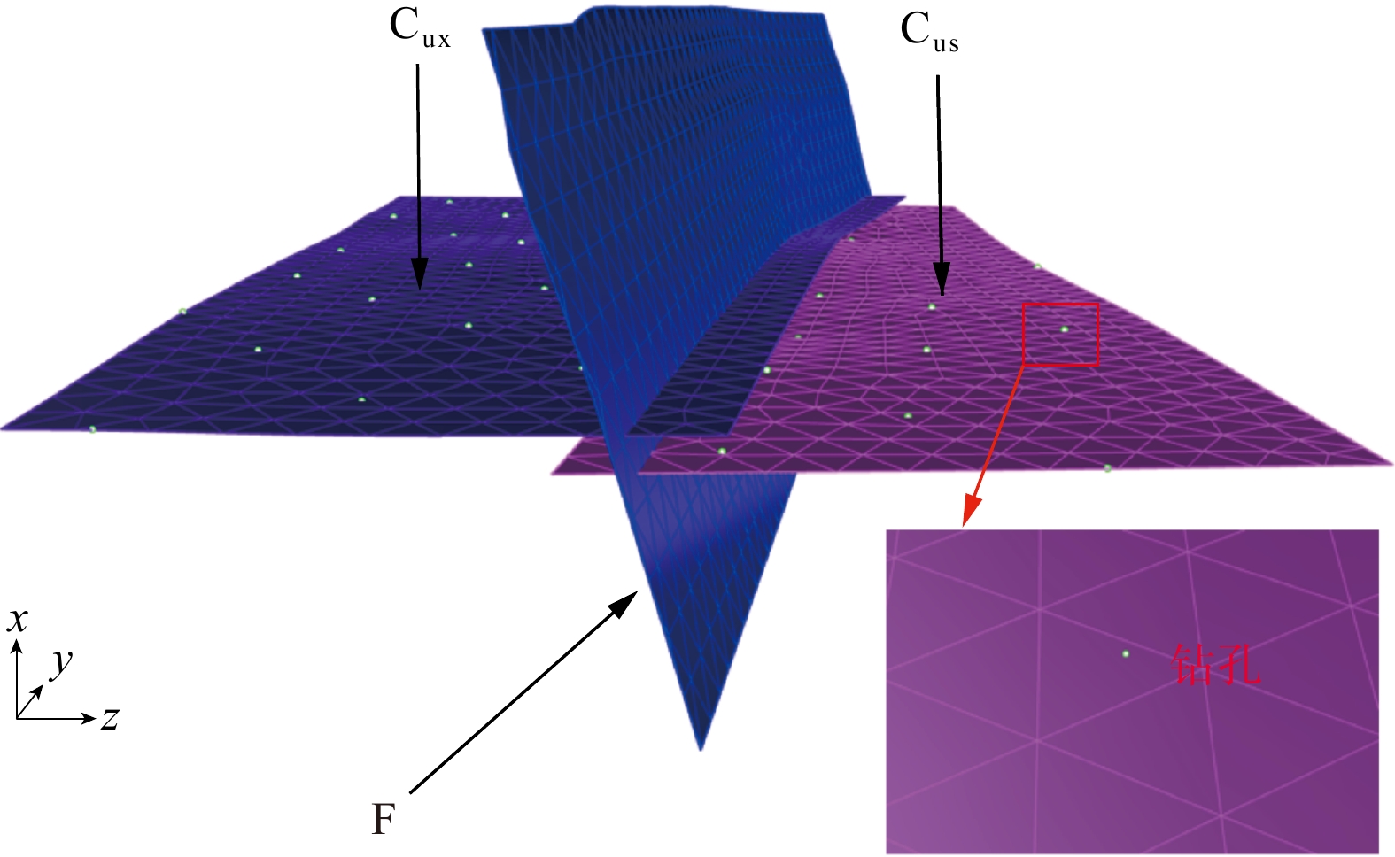
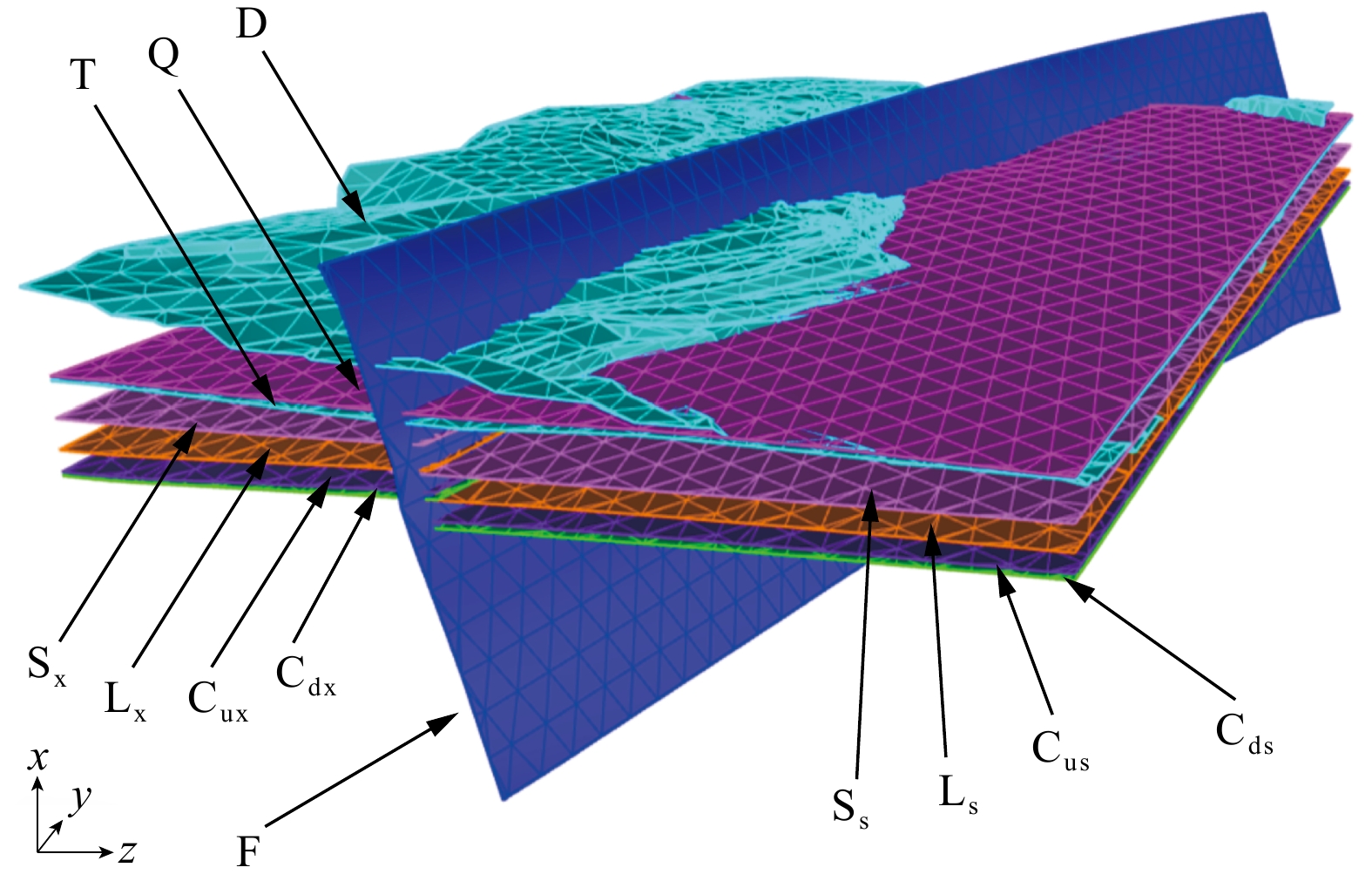
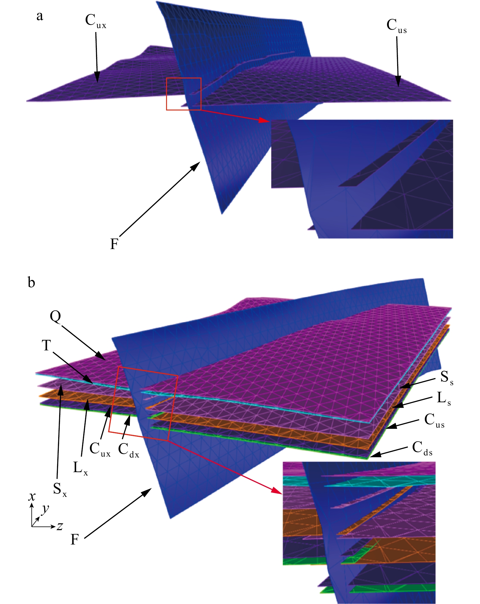
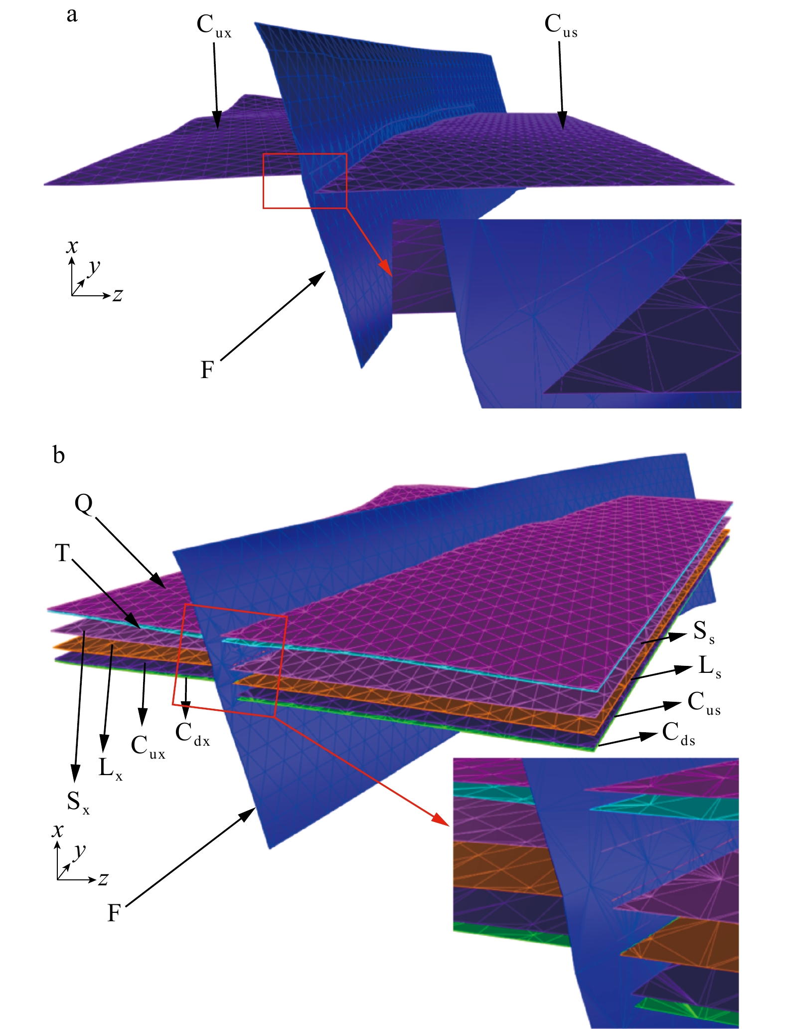
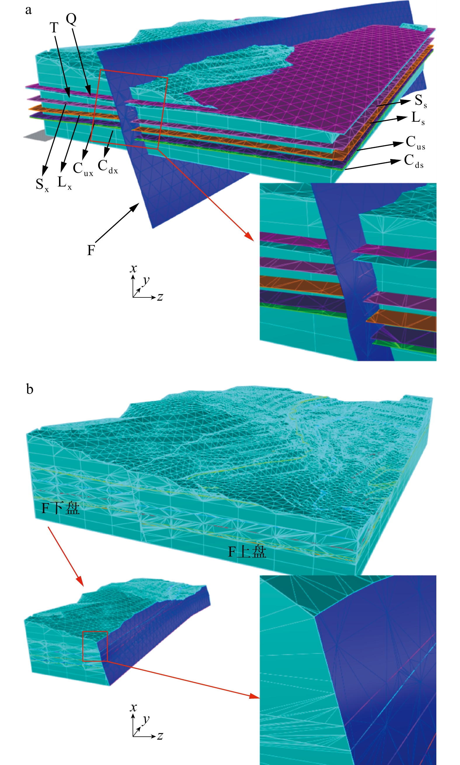
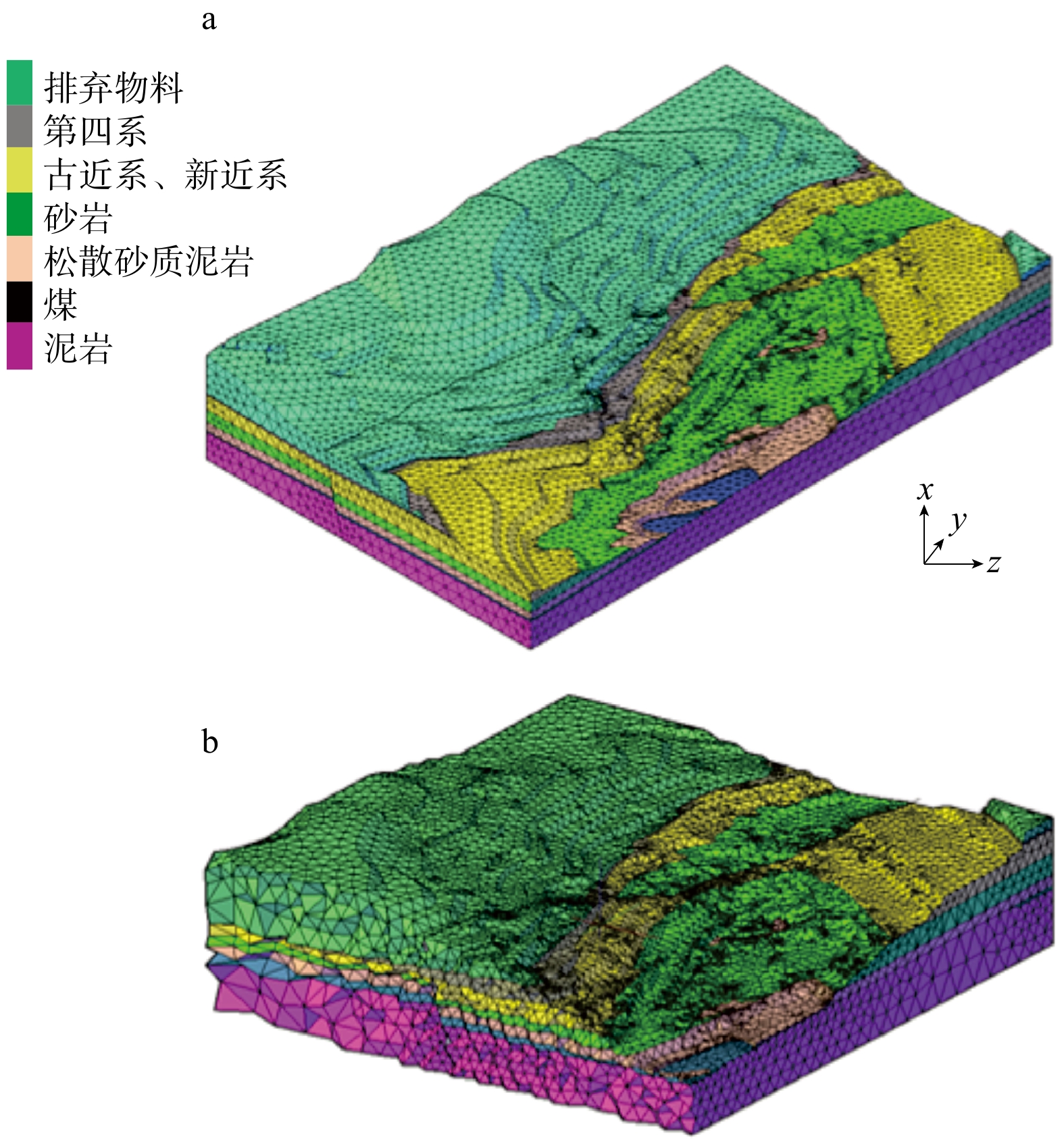
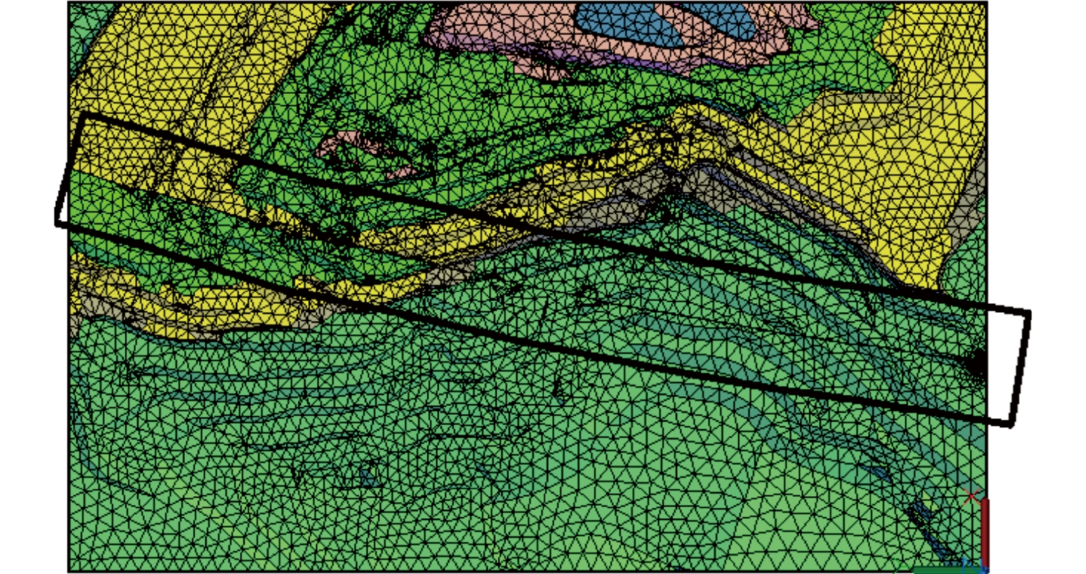
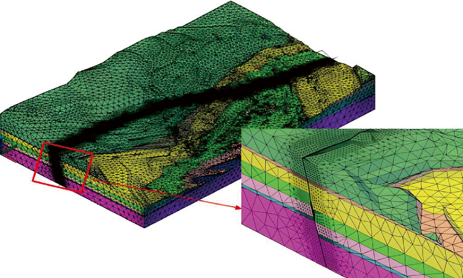
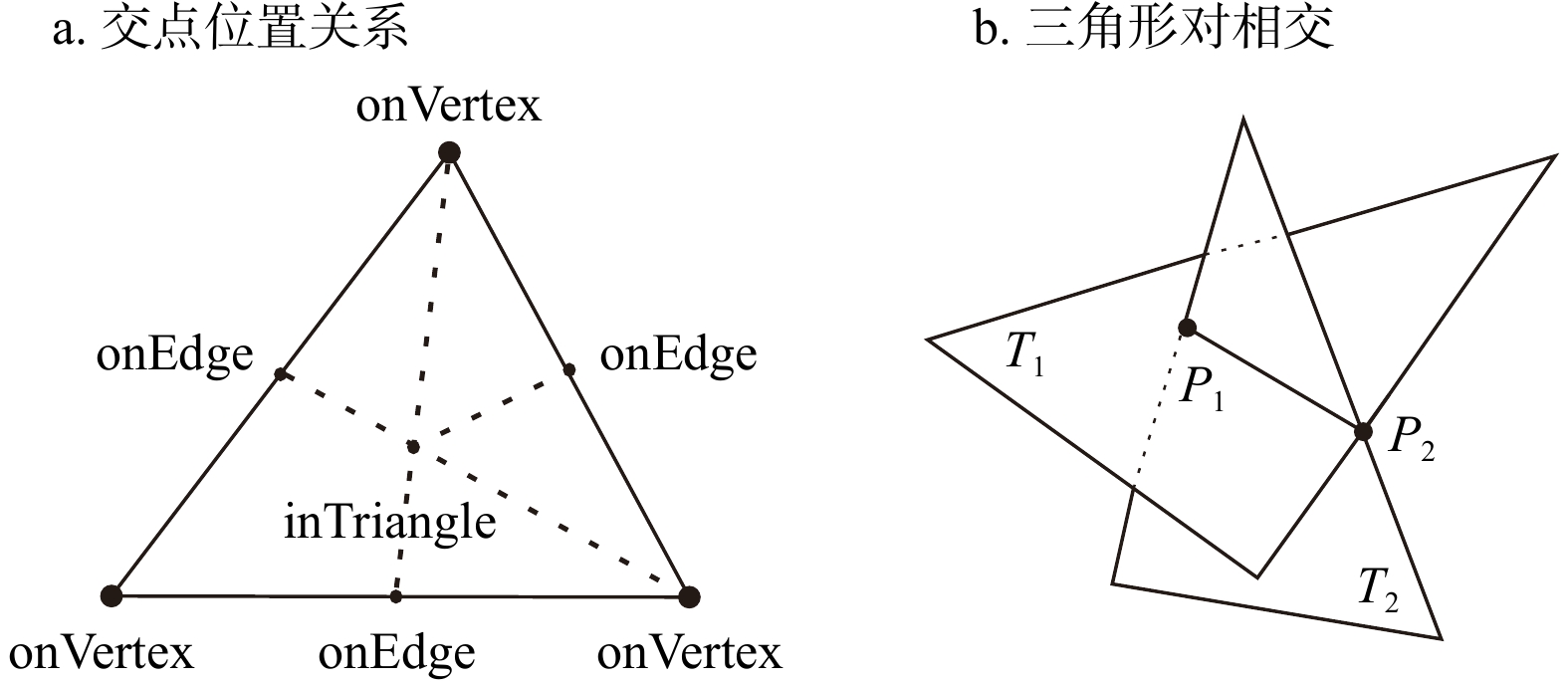
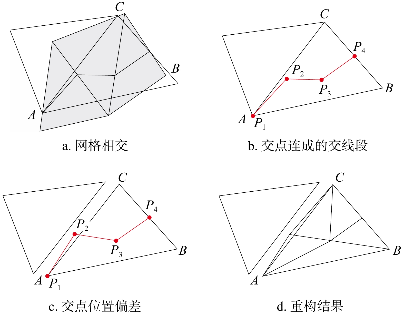
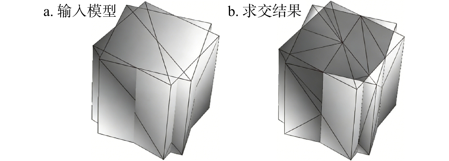
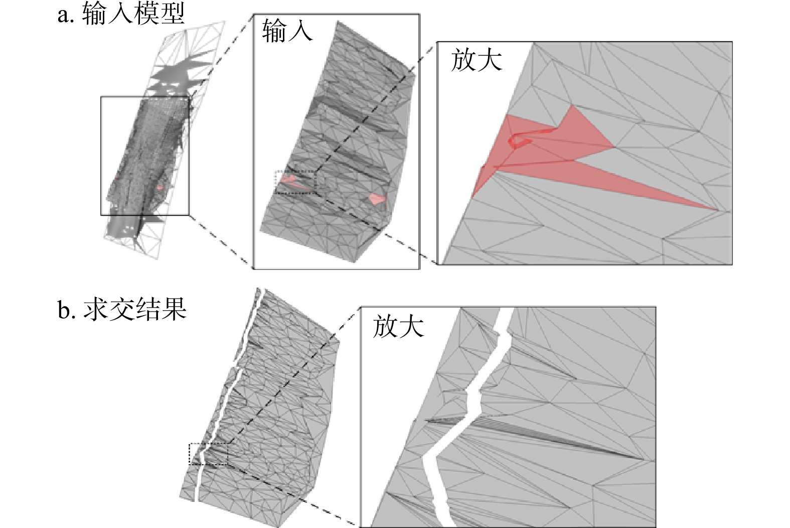
To address the problems of low accuracy and numerical errors in the current intersection methods for 3D geological models, this paper proposes a precise intersection algorithm for geological bodies based on the triangulated irregular network (TIN) and integrating floating-point arithmeticwith exact arithmetic. The specific process is as follows: First, a oriented bounding box (OBB) hierarchy for the TIN is constructed, and a set of effectively intersecting triangle pairs is identified through fast collision detection, thereby greatly reducing the scope of subsequent calculations. Second, the intersecting triangle pairs are decomposed into edge-triangle intersection tests, and an intersection positional-relationship data structure is established. This structure includes the spatial position states of intersections (atVertex: at a vertex, onEdge: on an edge, inTriangle: inside the face) and the IDs of corresponding entities (points, edges, faces). It not only eliminates redundant computations of intersection coordinates but also accurately identifies duplicate intersections by matching positional states with entity IDs (e.g., matching vertex IDs in the atVertex state and edge IDs in the onEdge state). Finally, the precision mode is selected dynamically according to the requirements of topological correctness: if floating-point precision can maintain topological correctness, projection-based constrained delaunay triangulation (CDT) is used to perform retriangulation; if deviations such as intersection position offsets (e.g., an inTriangle point projected outside the edge), point coincidence, or spurious intersections between intersection segments occur, the algorithm switches to exact precision represented by rational numbers. Retriangulation is carried out through constrained point insertion (an inTriangle point splits a triangle into three new triangles, and an onEdge point splits adjacent triangles into four new triangles) and constrained line-segment insertion (processing intersecting line segments and implementing edge-swap rules: Direct edge swapping for convex quadrilaterals and queued edge swapping for concave quadrilaterals), thereby ensuring the topological consistency of the reconstructed results. Experimental results show that the proposed algorithm effectively supports intersection operation on triangular networks, requires infrequent conversions to exact precision, and exhibits good computational efficiency and high robustness. The average runtime is lower than that of GOCAD, and the method meets the intersection requirements of most complex geological models based on triangulated irregular networks.
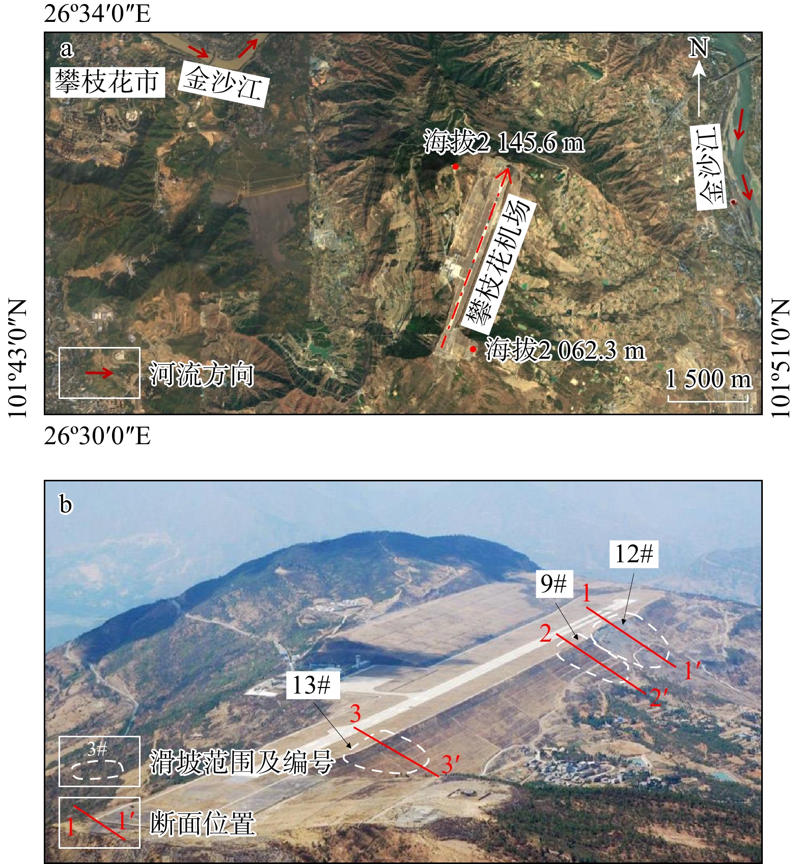
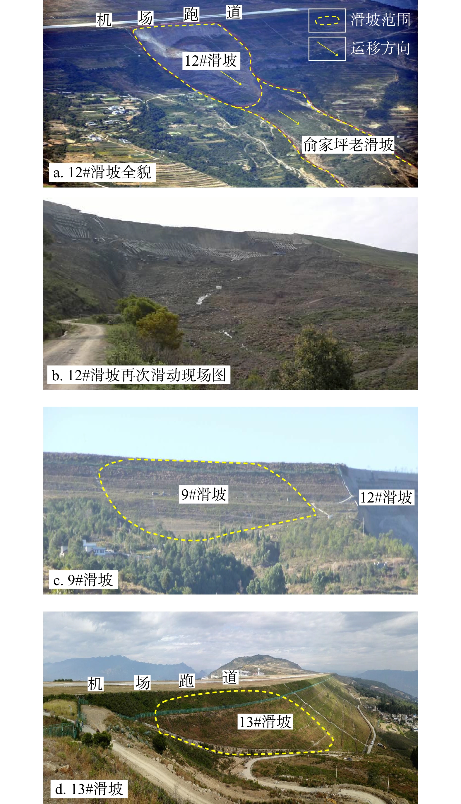
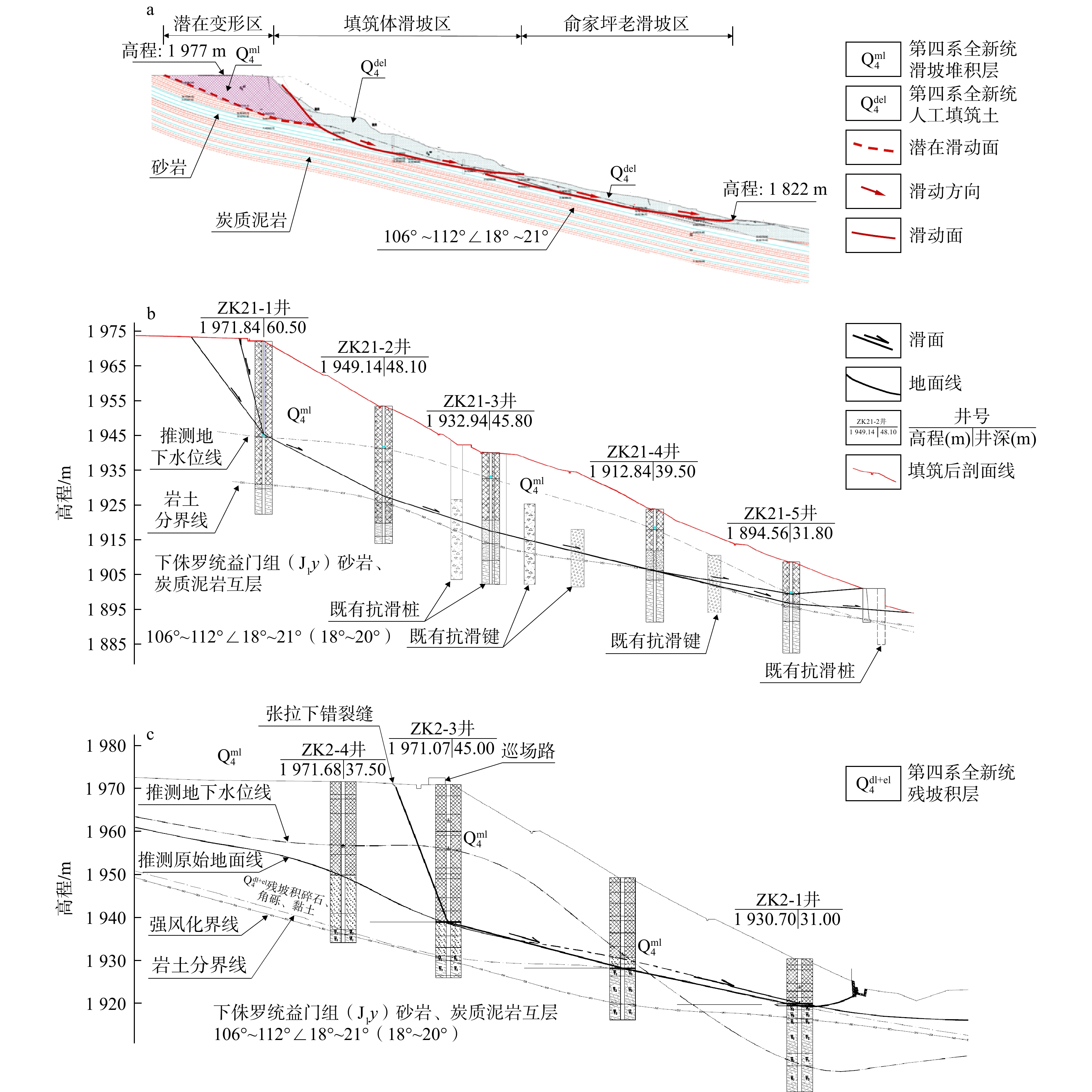
</p></sec></span> </div> <!-- 当期滚动图 --> <div class="curtu device curtu-show"> <div class="picBox" > <ul class="picList clear"> <li class="item"> <a class="group3" title="1" href="/fileDZKJTB//journal/article/dzkjtb/2026/1/tb20240105-1.jpg"> <img srcl="/fileDZKJTB//journal/article/dzkjtb/2026/1/tb20240105-1_mini.jpg" onerror="this.onerror=null;this.src='/fileDZKJTB//journal/article/dzkjtb/2026/1/tb20240105-1.jpg'" style="max-width:450px; max-height:158px;margin:0 auto;" /> </a> </li> <li class="item"> <a class="group3" title="1" href="/fileDZKJTB//journal/article/dzkjtb/2026/1/tb20240105-2.jpg"> <img srcll="/fileDZKJTB//journal/article/dzkjtb/2026/1/tb20240105-2_mini.jpg" onerror="this.onerror=null;this.src='/fileDZKJTB//journal/article/dzkjtb/2026/1/tb20240105-2.jpg'" style="max-width:450px; max-height:158px;margin:0 auto;" /> </a> </li> <li class="item"> <a class="group3" title="1" href="/fileDZKJTB//journal/article/dzkjtb/2026/1/tb20240105-3.jpg"> <img srcll="/fileDZKJTB//journal/article/dzkjtb/2026/1/tb20240105-3_mini.jpg" onerror="this.onerror=null;this.src='/fileDZKJTB//journal/article/dzkjtb/2026/1/tb20240105-3.jpg'" style="max-width:450px; max-height:158px;margin:0 auto;" /> </a> </li> <li class="item"> <a class="group3" title="1" href="/fileDZKJTB//journal/article/dzkjtb/2026/1/tb20240105-4.jpg"> <img srcll="/fileDZKJTB//journal/article/dzkjtb/2026/1/tb20240105-4_mini.jpg" onerror="this.onerror=null;this.src='/fileDZKJTB//journal/article/dzkjtb/2026/1/tb20240105-4.jpg'" style="max-width:450px; max-height:158px;margin:0 auto;" /> </a> </li> <li class="item"> <a class="group3" title="1" href="/fileDZKJTB//journal/article/dzkjtb/2026/1/tb20240105-5.jpg"> <img srcll="/fileDZKJTB//journal/article/dzkjtb/2026/1/tb20240105-5_mini.jpg" onerror="this.onerror=null;this.src='/fileDZKJTB//journal/article/dzkjtb/2026/1/tb20240105-5.jpg'" style="max-width:450px; max-height:158px;margin:0 auto;" /> </a> </li> <li class="item"> <a class="group3" title="1" href="/fileDZKJTB//journal/article/dzkjtb/2026/1/tb20240105-6.jpg"> <img srcll="/fileDZKJTB//journal/article/dzkjtb/2026/1/tb20240105-6_mini.jpg" onerror="this.onerror=null;this.src='/fileDZKJTB//journal/article/dzkjtb/2026/1/tb20240105-6.jpg'" style="max-width:450px; max-height:158px;margin:0 auto;" /> </a> </li> <li class="item"> <a class="group3" title="1" href="/fileDZKJTB//journal/article/dzkjtb/2026/1/tb20240105-7.jpg"> <img srcll="/fileDZKJTB//journal/article/dzkjtb/2026/1/tb20240105-7_mini.jpg" onerror="this.onerror=null;this.src='/fileDZKJTB//journal/article/dzkjtb/2026/1/tb20240105-7.jpg'" style="max-width:450px; max-height:158px;margin:0 auto;" /> </a> </li> <li class="item"> <a class="group3" title="1" href="/fileDZKJTB//journal/article/dzkjtb/2026/1/tb20240105-8.jpg"> <img srcll="/fileDZKJTB//journal/article/dzkjtb/2026/1/tb20240105-8_mini.jpg" onerror="this.onerror=null;this.src='/fileDZKJTB//journal/article/dzkjtb/2026/1/tb20240105-8.jpg'" style="max-width:450px; max-height:158px;margin:0 auto;" /> </a> </li> <li class="item"> <a class="group3" title="1" href="/fileDZKJTB//journal/article/dzkjtb/2026/1/tb20240105-9.jpg"> <img srcll="/fileDZKJTB//journal/article/dzkjtb/2026/1/tb20240105-9_mini.jpg" onerror="this.onerror=null;this.src='/fileDZKJTB//journal/article/dzkjtb/2026/1/tb20240105-9.jpg'" style="max-width:450px; max-height:158px;margin:0 auto;" /> </a> </li> </ul> <a class="iconfont icon-jiantou1 picPrev"></a> <a class="iconfont icon-jiantou picNext"></a> </div> </div> <!-- 引用信息,用于合并...参考文献格式 --> <div style="display: none;" class="citation"> LI Yida,ZHU Shuang,ZHENG Guizhou. An exact intersection method for triangulated irregular network and its application to 3D geological modeling[J]. Bulletin of Geological Science and Technology,2026,45(1):351-359. doi: 10.19509/j.cnki.dzkq.tb20240105.</div> </div> </div> <div class="article-list" id="e07154cb-71c6-4747-98ad-91aca622ab78"> <div class="article-list-left"><input name="journalArticleCheck" value="e07154cb-71c6-4747-98ad-91aca622ab78" type="checkbox" checkArticleId="e07154cb-71c6-4747-98ad-91aca622ab78"></div> <div class="article-list-right"> <div class="article-list-title"> <a target="_blank" href="//dzkjtb.cug.edu.cn/en/article/doi/10.19509/j.cnki.dzkq.tb20240348" class="">Rock image lithology recognition method based on lightweight convolutional neural network</a> </div> <div class="article-list-author"> <span> <a onclick='searchLike("authorNameEn","LIU Shanwei","");' href="javascript:void(0);">LIU Shanwei</a>, </span> <span> <a onclick='searchLike("authorNameEn"," MA Zhiwei","");' href="javascript:void(0);"> MA Zhiwei</a>, </span> <span> <a onclick='searchLike("authorNameEn"," WEI Shiqing","");' href="javascript:void(0);"> WEI Shiqing</a>, </span> <span> <a onclick='searchLike("authorNameEn"," WEI Zhongyong","");' href="javascript:void(0);"> WEI Zhongyong</a></span> </div> <div class="article-list-time"> <font>2026, 45(1): 360-370.</font> <font>doi: <a href="http://dx.doi.org/10.19509/j.cnki.dzkq.tb20240348" target="_blank" class="mainColor">10.19509/j.cnki.dzkq.tb20240348</a></font> </div> <div class="article-list-zy clear"> <div class="box"> <font class="font1"> <a target="_blank" href="//dzkjtb.cug.edu.cn/en/article/doi/10.19509/j.cnki.dzkq.tb20240348">Abstract</a> </font> <font class="font2 count1"> <a target="_blank" href="//dzkjtb.cug.edu.cn/en/article/doi/10.19509/j.cnki.dzkq.tb20240348">FullText HTML</a> </font> <font class="font3"><a href="javascript:void(0);" onclick="downloadpdf('e07154cb-71c6-4747-98ad-91aca622ab78');">PDF</a></font> <font class="font3 citedby-font" style="display:none;"> <a href="//dzkjtb.cug.edu.cn/en/article/doi/10.19509/j.cnki.dzkq.tb20240348#citedby-info" target="_blank">Cited By</a> </font> <span class="static-info fr"> <font class="font5"><img src="//dzkjtb.cug.edu.cn/style/web/images/custom/views.png" alt="icon"><span class="colorRed abs-num">562</span></font> <font class="font7" onclick="downloadpdf('e07154cb-71c6-4747-98ad-91aca622ab78');"><img src="//dzkjtb.cug.edu.cn/style/web/images/custom/down.png" alt="icon"><span class="colorRed pdf-num">47</span></font> <font class="font8 citedby-font" style="display:none;"><img src="//dzkjtb.cug.edu.cn/style/web/images/custom/cited.png" alt="icon"><span class="colorRed citedBy-num"></span></font> <span> </div> </div> <div class="article-list-zy morenstyle"> <b>Abstract: </b><br/> <span class="search-article-abstract hidden_line_show"><sec><title>Objective

Lithology identification is a crucial step in the process of oil and gas detection and exploration, providing important guidance for exploration positioning, reservoir evaluation, and the establishment of reservoir models. However, traditional manual lithology identification methods are time-consuming and labor-intensive. Although classical deep learning models achieve high identification accuracy, they often have a large number of parameters. To enhance model accuracy while reducing the number of parameters, the aim of this research is to make the model suitable for real-time lithology identification.

Methods

This paper first collected a dataset of 3016 rock images consisting of eight types of rocks, including dolomite and sandstone. Based on the lightweight convolutional neural network ShuffleNetV2, the paper proposes a Rock-ShuffleNetV2 lithology identification model (RSHFNet model). The model incorporates the convolutional block attention module (CBAM) and multi-scale feature fusion module (MSF) into the basic network to enhance feature extraction capabilities and improve identification performance. Additionally, the number of stacked ShuffleNetV2 units is optimized to reduce the model's parameters.

Results

The experimental results show that the RSHFNet model achieved an accuracy of 87.21%, which is a 4.98% improvement over the baseline model. Furthermore, the model's parameters and floating-point operations were reduced to 869702, 0.93×10⁸, respectively, representing 67% of the model's parameters and 63% of the floating-point operations of the baseline model. This reduction significantly decreases the model's size. Additionally, the RSHFNet model demonstrates superior overall performance compared to existing convolutional neural networks.

Conclusion

The proposed RSHFNet lithology identification model offers high recognition accuracy and strong generalization capabilities while being more lightweight, providing a new approach for real-time lithology identification in the field.