| Citation: | LIU Zhi,LI Yanxing,YANG Bo,et al. Extraction of remote sensing ore-indicating information and block optimization in middle-northern segment of Zhongtiao Mountain, Shanxi Province[J]. Bulletin of Geological Science and Technology,2026,45(2):274-292 doi: 10.19509/j.cnki.dzkq.tb20240617

|
Ore block optimization is an important task in the new round of strategic prospecting breakthrough actions, and a key initiative to respond to the Ministry of Natural Resources in further improving the efficiency of prospecting, developing new-quality productive forces, and enhancing the support capacity of mineral resources. As one of China's key national strategic resource concentration areas for gold, copper, iron, and other critical minerals, the Zhongtiao Mountain in Shanxi Province is abundant in mineral resources. However, to date, there is relatively limited research on the large-scale remote sensing geological interpretation and prospecting applications based on remote sensing satellite images in this region, which is of great significance for prospecting prediction.
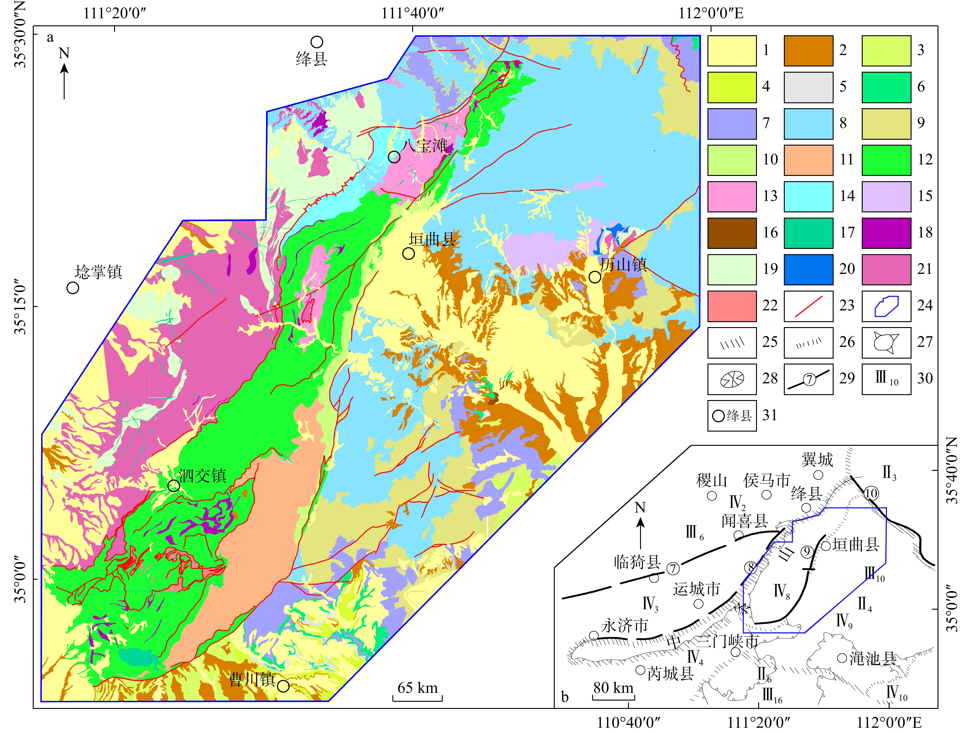
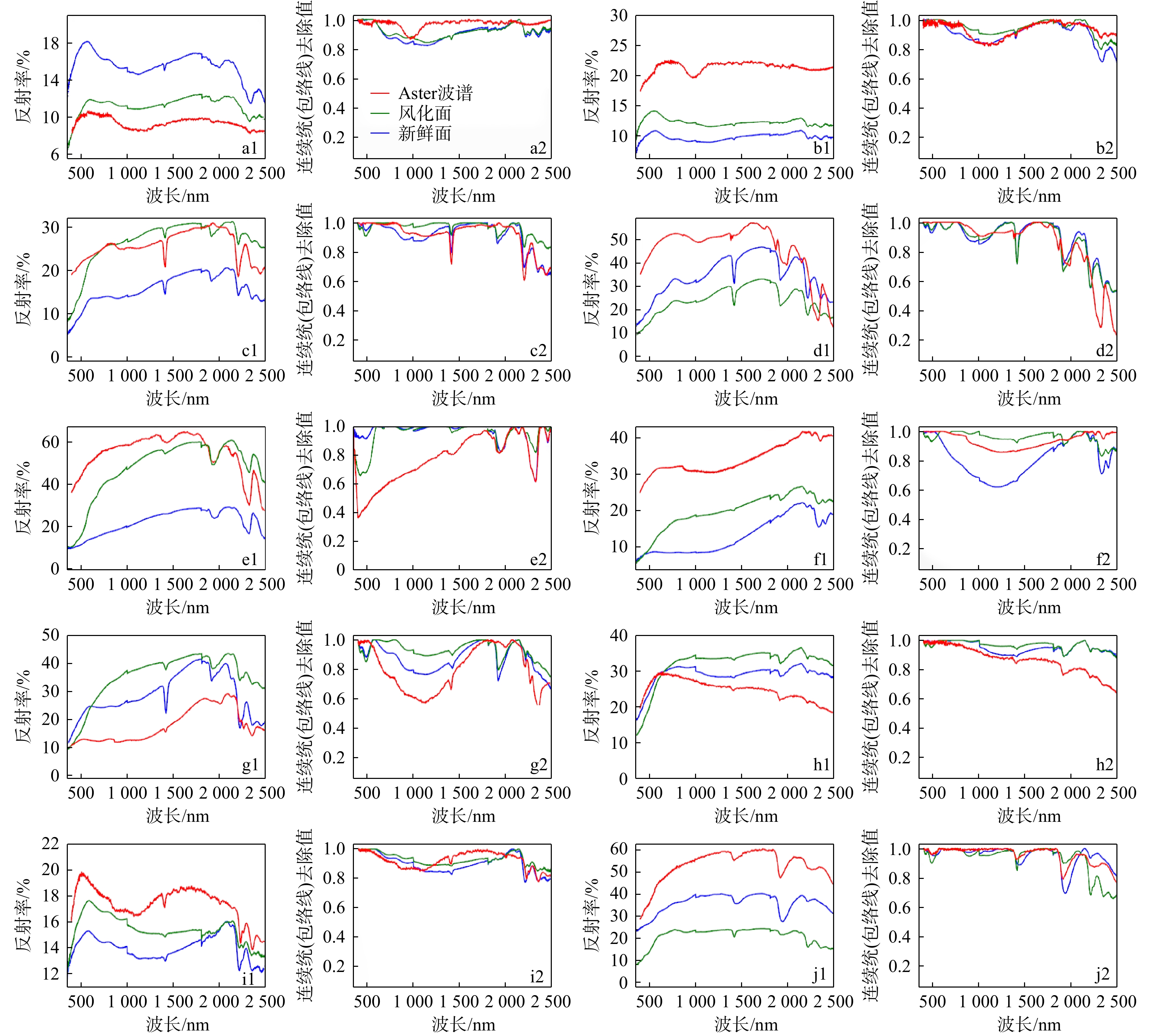
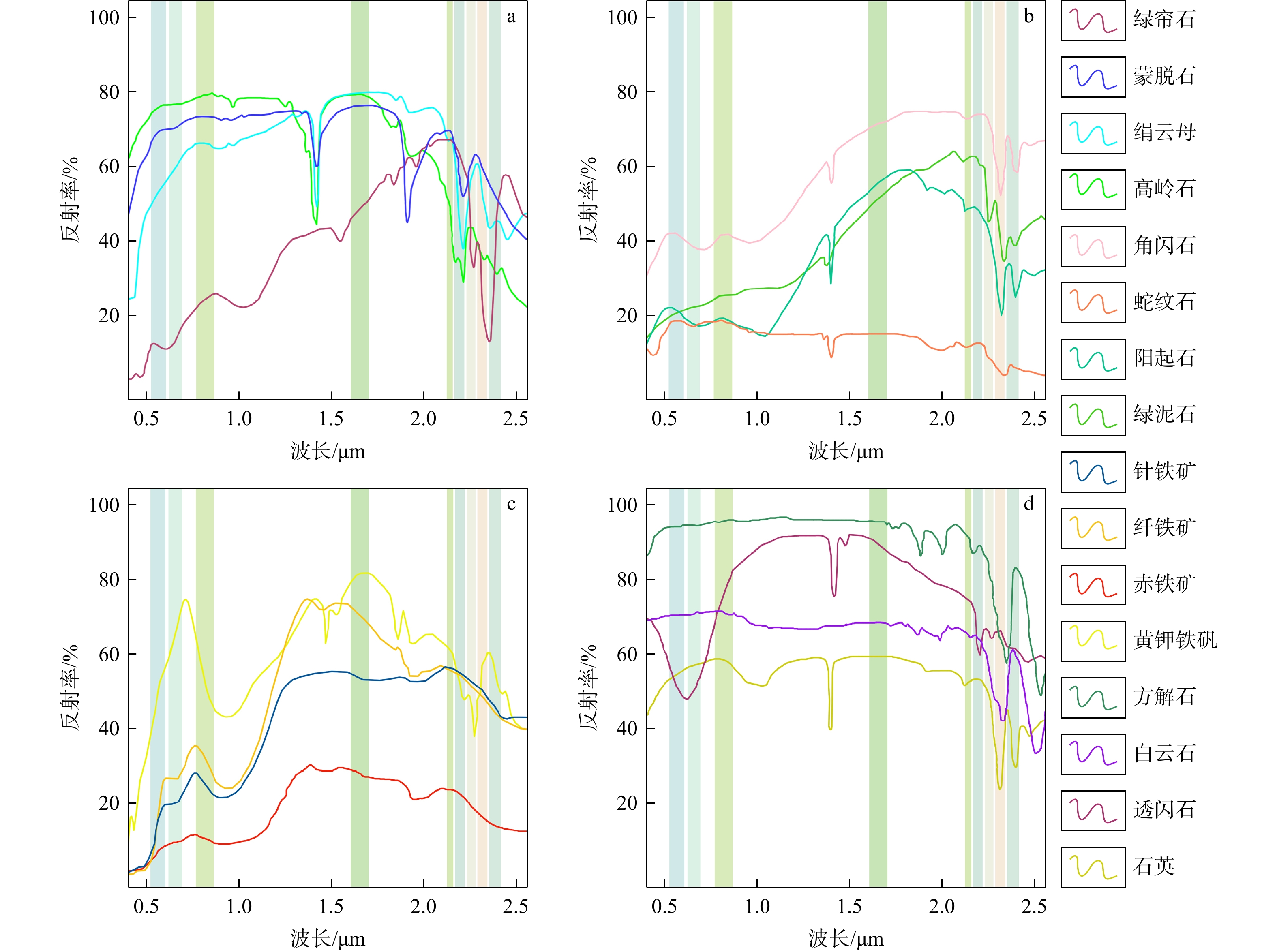
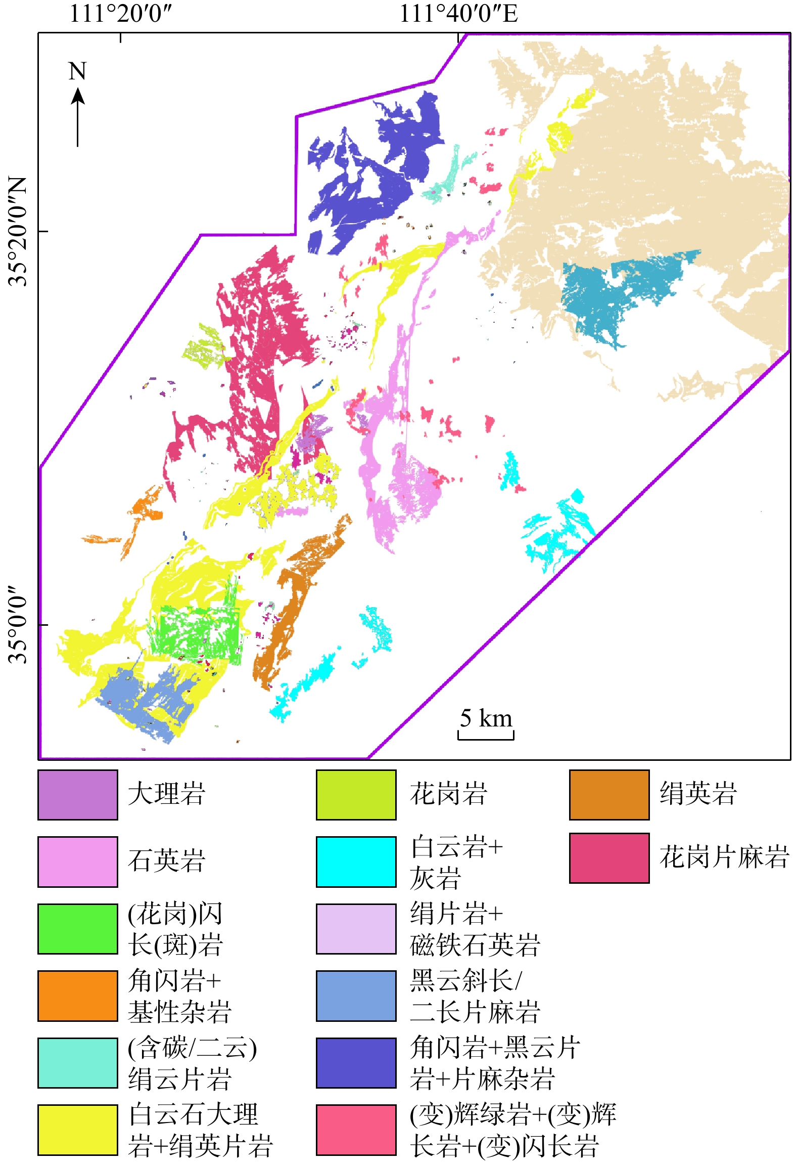
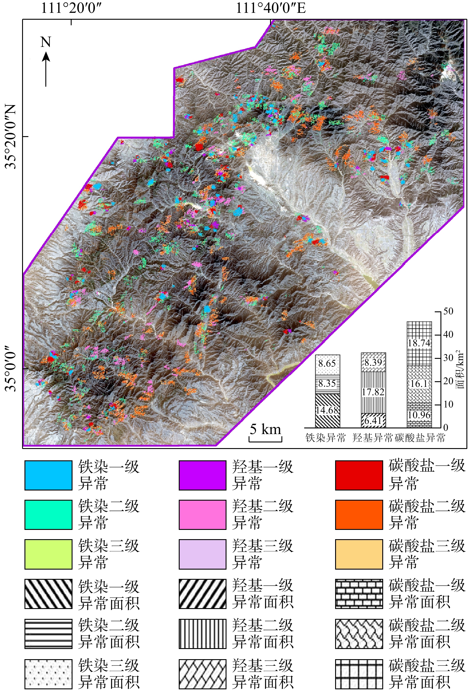
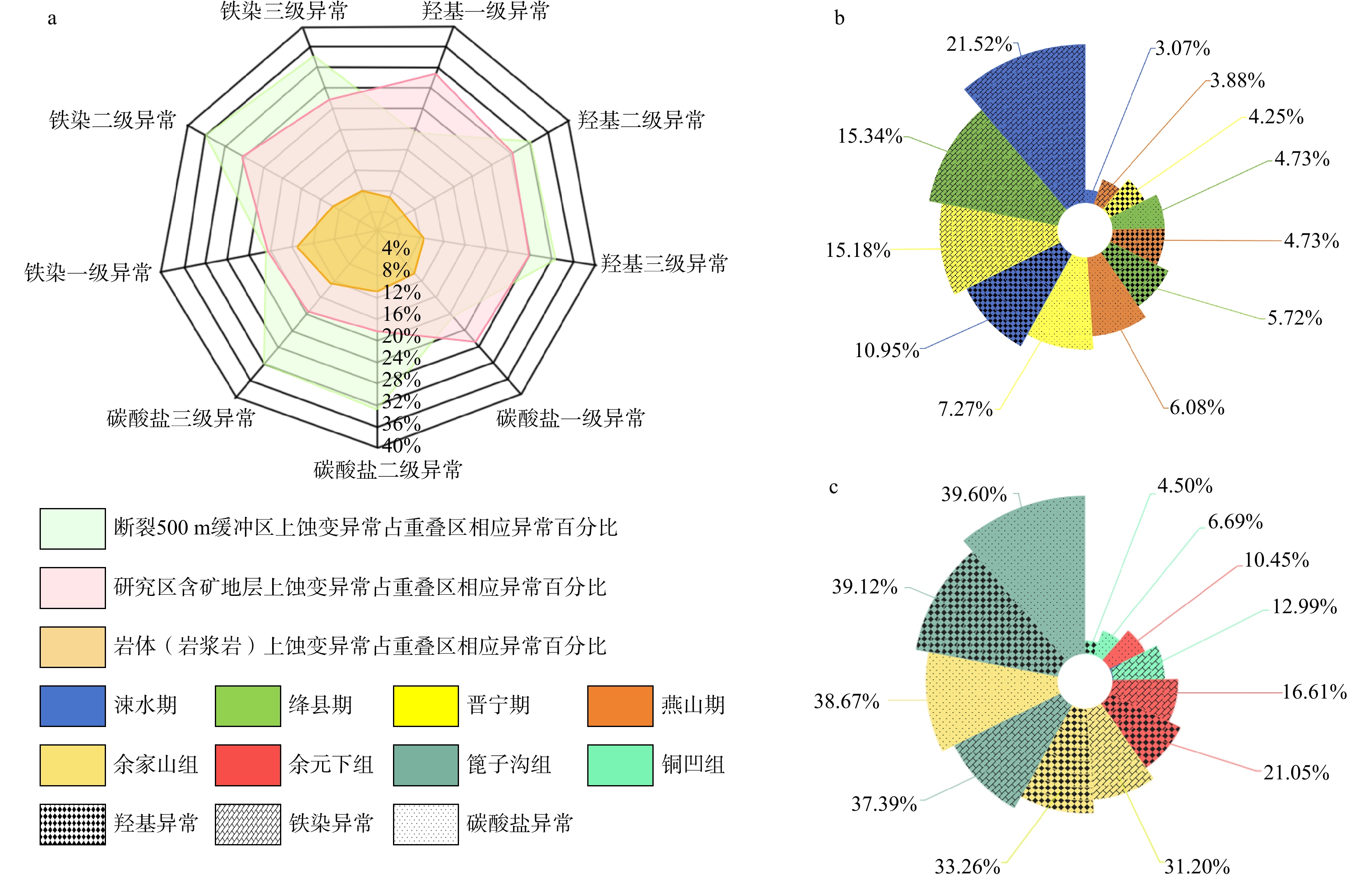
The middle-northern segment of the Zhongtiao Mountain in Shanxi Province was selected as the study area. Based on human-computer interactive interpretation of ore-controlling structural and ore-controlling ring features from Spot-6 remote sensing images, the regional structural distribution of the study area was summarized from a macro perspective. Principal component analysis (PCA) was employed to preliminarily extract mineralization alteration anomaly information via Aster data. Additionally, with field spectral curves of typical rocks and minerals collected by an ASD spectrometer as training samples, the spectral angle mapping (SAM) method was applied to extract the distribution of ore-bearing strata. The distribution results were then used to screen the PCA extraction results to identify three major types of mineralization alterations, including iron staining, hydroxyl, and carbonate. The spatial correlation between alteration anomalies and ore-controlling factors (such as regional structures, ore-bearing strata, and rock mass distribution) was further analyzed.
The results indicated that: (1) The linear and ring structures were well-developed in the study area, with 84 newly interpreted faults and 136 ring structures, which helped refine and supplement the shortcomings of previous geological survey findings. (2) The mineralization and alteration information obtained by PCA and rock-ore spectral inversion could effectively indicate mineralization anomalies, highlighting the important role of regional structures in ore formation. (3) A comprehensive anomaly isodensity map was obtained through combined analysis of field verification and existing regional geological data to delineate three optimal mineralization areas.
The research findings provide a basis and guidance for subsequent evaluation of mineral resource potential, prospecting prediction, and strategic actions of deep prospecting. The findings also promote the application of remote sensing-based geological prospecting in the Zhongtiao Mountain, and provide insights into future remote sensing-based geological prospecting efforts in other regions of Shanxi Province.

| [1] |
CRÓSTA A P, MOORE J M. Enhancement of landsat thematic mapper imagery for residual soil mapping in SW Minais Gerais State, Brazil: A prospecting case history in greenstone belt terrain[C]//Institute of Michigan. Proceedings of the Seventh Thematic Conference on Remote Sensing for Exploration Geology: Methods Integration Solutions. Calgary: Institute of Michigan, 1989: 1173-1187.
|
| [2] |
RAJESH H M. Mapping Proterozoic unconformity-related uranium deposits in the Rockhole area, northern Territory, Australia using landsat ETM+[J]. Ore Geology Reviews, 2008, 33(3/4): 382-396. doi: 10.1016/j.oregeorev.2007.02.003
|
| [3] |
NGCOFE L, MINNAAR H, CHEVALLIER L. A comparative study of hyperspectral versus multispectral images as an aid in geological mapping near Alexander Bay, northern Cape, South Africa[J]. South African Journal of Geology, 2010, 113(2): 141-154.
|
| [4] |
张亮, 那晓东, 刘知, 等. 基于国产GF-2卫星影像的遥感地质解译: 以阿吾拉勒地区为例[J]. 地质科技情报, 2018, 37(2): 233-240.
ZHANG L, NA X D, LIU Z, et al. Remote sensing geological interpretation based on domestic GF-2 satellite imagery: A case study of the Awulale area[J]. Geological Science and Technology Information, 2018, 37(2): 233-240. (in Chinese with English abstract
|
| [5] |
JAIN R, SHARMA R U. Airborne hyperspectral data for mineral mapping in southeastern Rajasthan, India[J]. International Journal of Applied Earth Observation and Geoinformation, 2019, 81: 137-145. doi: 10.1016/j.jag.2019.05.007
|
| [6] |
KUMAR C, CHATTERJEE S, OOMMEN T, et al. Automated lithological mapping by integrating spectral enhancement techniques and machine learning algorithms using AVIRIS-NG hyperspectral data in Gold-bearing granite-greenstone rocks in Hutti, India[J]. International Journal of Applied Earth Observation and Geoinformation, 2020, 86: 102006. doi: 10.1016/j.jag.2019.102006
|
| [7] |
冯博, 段培新, 程旭, 等. 高分五号航天高光谱遥感技术在甘肃龙首山铀矿找矿中的应用[J]. 现代地质, 2022, 36(6): 1594-1604.
FENG B, DUAN P X, CHENG X, et al. Application of GF-5 satellite hyperspectral data to uranium ore geological prospecting in Longshoushan area in Gansu Province[J]. Geoscience, 2022, 36(6): 1594-1604. (in Chinese with English abstract
|
| [8] |
徐大兴, 杨彪, 邵兆刚, 等. 哈达门沟金矿蚀变分带的高光谱分析及找矿意义[J]. 自然资源遥感, 2023, 35(1): 123-131.
XU D X, YANG B, SHAO Z G, et al. A hyperspectral analysis of alteration zoning in the Hadamengou gold deposit and its significance for ore prospecting[J]. Remote Sensing for Natural Resources, 2023, 35(1): 123-131. (in Chinese with English abstract
|
| [9] |
YE B, TIAN S F, CHENG Q M, et al. Application of lithological mapping based on advanced hyperspectral imager (AHSI) imagery onboard Gaofen-5 (GF-5) satellite[J]. Remote Sensing, 2020, 12(23): 3990. doi: 10.3390/rs12233990
|
| [10] |
孙雨, 刘家军, 赵英俊, 等. 基于GF-5高光谱数据的蚀变矿物填图及地质应用: 以甘肃省瓜州县花牛山地区为例[J]. 中国地质, 2022, 49(2): 558-574.
SUN Y, LIU J J, ZHAO Y J, et al. Alteration mineral mapping based on the GF-5 hyperspectral data and its geological application: An example of the Huaniushan area in Guazhou County of Gansu Province[J]. Geology in China, 2022, 49(2): 558-574. (in Chinese with English abstract
|
| [11] |
SHEIKHRAHIMI A, POUR A B, PRADHAN B, et al. Mapping hydrothermal alteration zones and lineaments associated with orogenic gold mineralization using ASTER data: A case study from the Sanandaj-Sirjan Zone, Iran[J]. Advances in Space Research, 2019, 63(10): 3315-3332. doi: 10.1016/j.asr.2019.01.035
|
| [12] |
徐燕飞, 陈永春, 李静, 等. 煤电基地CO2和CH4遥感监测及时空特征分析[J]. 煤田地质与勘探, 2024, 52(6): 79-90.
XU Y F, CHEN Y C, LI J, et al. Remote sensing monitoring and spatiotemporal characteristics of CO2 and CH4 concentrations in coal-electricity production bases[J]. Coal Geology & Exploration, 2024, 52(6): 79-90. (in Chinese with English abstract
|
| [13] |
王晓云, 井国正, 李文君, 等. 基于多源遥感卫星数据的青海东昆仑沟里地区线性构造识别及找矿预测[J]. 地质科技通报, 2024, 43(1): 326-342. doi: 10.19509/j.cnki.dzkq.2022.0268
WANG X Y, JING G Z, LI W J, et al. Lineament mapping and deposit prospecting in the Gouli area, East Kunlun, Qinghai Province: Using multisource remote sensing data[J]. Bulletin of Geological Science and Technology, 2024, 43(1): 326-342. (in Chinese with English abstract doi: 10.19509/j.cnki.dzkq.2022.0268
|
| [14] |
陈富强. 伊宁至阿克苏铁路那拉提山越岭段关键性工程地质问题遥感解译与分析[J]. 地质科技通报, 2023, 42(2): 288-296. doi: 10.19509/j.cnki.dzkq.tb20210646
CHEN F Q. Remote sensing interpretation and analysis of key engineering geological problems in the Nalati Mountain crossing section of the Yining-Aksu Railway[J]. Bulletin of Geological Science and Technology, 2023, 42(2): 288-296. (in Chinese with English abstract doi: 10.19509/j.cnki.dzkq.tb20210646
|
| [15] |
LI X. A deep learning framework for the characterization of mineral in duced spectral signatures in high-dimensional reflectance data[J]. Remote Sensing, 2020, 12(8): 1274.
|
| [16] |
GALLWEY J, ROBIATI C, COGGAN J, et al. A Sentinel-2 based multispectral convolutional neural network for detecting artisanal small-scale mining in Ghana: Applying deep learning to shallow mining[J]. Remote Sensing of Environment, 2020, 248: 111970. doi: 10.1016/j.rse.2020.111970
|
| [17] |
SALATI S, VAN RUITENBEEK F, VAN DER MEER F, et al. Detection of alteration induced by onshore gas seeps from ASTER and WorldView-2 data[J]. Remote Sensing, 2014, 6(4): 3188-3209. doi: 10.3390/rs6043188
|
| [18] |
AMER R, EL MEZAYEN A, HASANEIN M. ASTER spectral analysis for alteration minerals associated with gold mineralization[J]. Ore Geology Reviews, 2016, 75: 239-251. doi: 10.1016/j.oregeorev.2015.12.008
|
| [19] |
侯占国, 赵增杰, 李嵩, 等. 山西省矿产资源潜力评价项目报告[R]. 太原: 山西省地质调查院, 2012.
HOU Z G, ZHAO Z J, LI S, et al. Shanxi Province mineral resource potential assessment project report[R]. Taiyuan: Geological Survey of Shanxi Province, 2012. (in Chinese)
|
| [20] |
杨映春, 李云平, 曹有全. 基于Landsat 8和高分一号卫星数据的青海巴尔达吾地区铅、镍多金属矿化信息提取[J]. 矿产勘查, 2024, 15(10): 1824-1833.
YANG Y C, LI Y P, CAO Y Q. Extraction of lead, nickel polymetallic mineralization information in Baldau, Qinghai based on Landsat 8 and GF-1 data[J]. Mineral Exploration, 2024, 15(10): 1824-1833. (in Chinese with English abstract
|
| [21] |
谢文扬, 刘磊, 赵英芬. 基于GF-1和Landsat 8影像的新疆东天山昌吉地区岩性识别[J]. 遥感技术与应用, 2023, 38(6): 1423-1432. doi: 10.11873/j.issn.1004-0323.2023.6.1423
XIE W Y, LIU L, ZHAO Y F. Lithology identification in Changji area, eastern Tianshan, Xinjiang using GF-1 and Landsat 8 data[J]. Remote Sensing Technology and Application, 2023, 38(6): 1423-1432. (in Chinese with English abstract doi: 10.11873/j.issn.1004-0323.2023.6.1423
|
| [22] |
陈玲, 贾佳, 王海庆. 高分遥感在自然资源调查中的应用综述[J]. 国土资源遥感, 2019, 31(1): 1-7.
CHEN L, JIA J, WANG H Q. An overview of applying high resolution remote sensing to natural resources survey[J]. Remote Sensing for Land & Resources, 2019, 31(1): 1-7. (in Chinese with English abstract
|
| [23] |
魏长婧. 遥感技术在矿业领域的应用现状及发展趋势综述[J]. 北京测绘, 2022, 36(10): 1285-1292. doi: 10.19580/j.cnki.1007-3000.2022.10.001
WEI C J. Application status and development trend of the remote sensing technology in mining areas[J]. Beijing Surveying and Mapping, 2022, 36(10): 1285-1292. (in Chinese with English abstract doi: 10.19580/j.cnki.1007-3000.2022.10.001
|
| [24] |
孙军刚, 李洪英, 刘晓煌, 等. 中条山铜矿峪铜矿床蚀变及矿化特征研究[J]. 矿床地质, 2014, 33(6): 1306-1324. doi: 10.3969/j.issn.0258-7106.2014.06.010
SUN J G, LI H Y, LIU X H, et al. Alteration and mineralization characteristics of Tongkuangyu copper deposit in Zhongtiao Mountain, Shanxi Province[J]. Mineral Deposits, 2014, 33(6): 1306-1324. (in Chinese with English abstract doi: 10.3969/j.issn.0258-7106.2014.06.010
|
| [25] |
SEIFI A, ESMAEILY A, MOKHTARI Z. A new hybrid method for epithermal gold exploration using multi-sensor satellite data in Sistan and Baluchestan Province (Iran)[J]. Ore Geology Reviews, 2021, 138: 104357. doi: 10.1016/j.oregeorev.2021.104357
|
| [26] |
HUANG X, ZHANG L P. An SVM ensemble approach combining spectral, structural, and semantic features for the classification of high-resolution remotely sensed imagery[J]. IEEE Transactions on Geoscience and Remote Sensing, 2013, 51(1): 257-272. doi: 10.1109/TGRS.2012.2202912
|
| [27] |
AMER R, KUSKY T, GHULAM A. Lithological mapping in the central eastern desert of Egypt using ASTER data[J]. Journal of African Earth Sciences, 2010, 56(2/3): 75-82. doi: 10.1016/j.jafrearsci.2009.06.004
|
| [28] |
JIANG Y T. Research on road extraction of remote sensing image based on convolutional neural network[J]. EURASIP Journal on Image and Video Processing, 2019, 2019(1): 31. doi: 10.1186/s13640-019-0426-7
|
| [29] |
王生礼, 李志军. 遥感蚀变信息提取研究综述[J]. 地质与资源, 2023, 32(4): 462-470.
WANG S L, LI Z J. A review of remote sensing alteration information extraction techniques[J]. Geology and Resources, 2023, 32(4): 462-470. (in Chinese with English abstract
|
| [30] |
白杨林, 吕凤军, 苏鸿博, 等. 高光谱遥感蚀变矿物信息提取研究综述[J]. 遥感信息, 2023, 38(1): 1-10. doi: 10.20091/j.cnki.1000-3177.2023.01.001
BAI Y L, LYU F J, SU H B, et al. Review of hyperspectral remote sensing altered mineral information extraction[J]. Remote Sensing Information, 2023, 38(1): 1-10. (in Chinese with English abstract doi: 10.20091/j.cnki.1000-3177.2023.01.001
|
| [31] |
王艺龙, 王然, 严子清, 等. 基于GF-2和ASTER数据青海德龙地区构造蚀变信息提取及找矿预测[J]. 自然资源遥感, 2024, 36(1): 217-226. doi: 10.6046/zrzyyg.2022444
WANG Y L, WANG R, YAN Z Q, et al. Tectonic alteration information extraction and prospecting prediction for the Delong area of Qinghai Province based on GF-2 and ASTER data[J]. Remote Sensing for Natural Resources, 2024, 36(1): 217-226. (in Chinese with English abstract doi: 10.6046/zrzyyg.2022444
|
| [32] |
韩燿徽, 王翠芝, 吴志杰, 等. 内蒙古赤峰柴胡栏子金矿田遥感地质解译和蚀变信息提取与找矿预测[J]. 现代地质, 2024, 38(4): 1076-1091. doi: 10.19657/j.geoscience.1000-8527.2023.112
HAN Y H, WANG C Z, WU Z J, et al. Remote sensing geological interpretation, alteration information extraction, and mineral prospecting prediction in the Chaihulanzi gold field, Chifeng, Inner Mongolia[J]. Geoscience, 2024, 38(4): 1076-1091. (in Chinese with English abstract doi: 10.19657/j.geoscience.1000-8527.2023.112
|
| [33] |
童勤龙, 叶发旺, 秦明宽, 等. WorldView-3遥感数据在巴音戈壁盆地本巴图地区铀矿勘查中的应用[J]. 地质论评, 2022, 68(6): 2349-2364. doi: 10.16509/j.georeview.2022.08.071
TONG Q L, YE F W, QIN M K, et al. Application of WorldView-3 remote sensing data to uranium exploration in Benbatu area, Bayingobi Basin[J]. Geological Review, 2022, 68(6): 2349-2364. (in Chinese with English abstract doi: 10.16509/j.georeview.2022.08.071
|
| [34] |
尹展, 张建国, 陈星霖, 等. 植被覆盖区老旧矿山边部遥感蚀变信息提取技术探讨[J]. 地质与资源, 2024, 33(2): 187-195. doi: 10.13686/j.cnki.dzyzy.2024.02.007
YIN Z, ZHANG J G, CHEN X L, et al. Alteration information extraction by remote sensing technology around old mines in vegetation-covered areas[J]. Geology and Resources, 2024, 33(2): 187-195. (in Chinese with English abstract doi: 10.13686/j.cnki.dzyzy.2024.02.007
|
| [35] |
赵佳琪, 董新丰, 李娜, 等. 基于高光谱数据的甘肃花西山金矿蚀变特征分析与找矿预测应用[J]. 地质与勘探, 2023, 59(1): 122-133. doi: 10.12134/j.dzykt.2023.01.010
ZHAO J Q, DONG X F, LI N, et al. Alteration characteristics and prospecting prediction of the Huaxishan gold deposit in Gansu Province based on hyperspectral data[J]. Geology and Exploration, 2023, 59(1): 122-133. (in Chinese with English abstract doi: 10.12134/j.dzykt.2023.01.010
|
| [36] |
祁昌炜, 董基恩, 程旭, 等. ZY-102D高光谱数据在柴北缘荒漠区蚀变矿物填图及找矿中的应用[J]. 自然资源遥感, 2024, 36(4): 31-42.
QI C W, DONG J E, CHENG X, et al. Application of ZY-102D hyperspectral data to altered mineral mapping and ore prospecting in desert areas along the northern margin of the Qaidam Basin[J]. Remote Sensing for Natural Resources, 2024, 36(4): 31-42. (in Chinese with English abstract
|
| [37] |
张玉君, 曾朝铭, 姚佛军. 利用光谱角填图(SAM)优化多光谱遥感异常[J]. 矿物学报, 2015, 35(增刊1): 985.
ZHANG Y J, ZENG Z M, YAO F J. Optimization of multispectral remote sensing anomaly by spectral angle mapping (SAM)[J]. Acta Mineralogica Sinica, 2015, 35(S1): 985. (in Chinese with English abstract
|
| [38] |
李嵩, 李海鹰. 遥感在矿产资源潜力评价中的综合应用研究: 以山西省为例[J]. 国土资源遥感, 2012, 24(1): 111-119. doi: 10.6046/gtzyyg.2012.01.20
LI S, LI H Y. A comprehensive study of applying remote sensing in the evaluation of mineral resource potential: A case study of the remote sensing application in Shanxi Province[J]. Remote Sensing for Land & Resources, 2012, 24(1): 111-119. (in Chinese with English abstract doi: 10.6046/gtzyyg.2012.01.20
|
| [39] |
薛克勤. 中条裂谷构造与成矿作用研究[D]. 北京: 中国地质大学(北京), 2006.
XUE K Q. Study on the relation between structure and metallogenesis in the Zhongtiao rift[D]. Beijing: China University of Geosciences(Beijing), 2006. (in Chinese with English abstract
|
| [40] |
韩月池. 论中条山中部地区地质地层概况[J]. 华北自然资源, 2019(6): 68-69.
HAN Y C. General situation of geological strata in the central area of Zhongtiaoshan Mountain[J]. Huabei Natural Resources, 2019(6): 68-69. (in Chinese with English abstract
|
| [41] |
真允庆, 杜继盛, 刘丽玲, 等. 中条裂谷与落家河铜矿床[M]. 武汉: 中国地质大学出版社, 1993.
ZHEN Y Q, DU J S, LIU L L, et al. The Zhongtiao rift zone and the Luojiahe copper deposit[M]. Wuhan: China University of Geosciences Press, 1993. (in Chinese)
|
| [42] |
孙继源, 冀树楷, 真允庆. 中条裂谷铜矿床[M]. 北京: 地质出版社, 1995.
SUN J Y, JI S K, ZHEN Y Q. The copper deposits in the Zhongtiao rift[M]. Beijing: Geological Publishing House, 1995. (in Chinese)
|
| [43] |
崔小军, 康顺福, 刘家军, 等. 中条裂谷的递进演化与王屋山地区铜矿成矿地质条件分析[J]. 地质找矿论丛, 2007, 22(1): 24-30.
CUI X J, KANG S F, LIU J J, et al. Stepwise evolution of Zhongtiao rift and analysis on copper mineralization conditions in Wangwushan region[J]. Contributions to Geology and Mineral Resources Research, 2007, 22(1): 24-30. (in Chinese with English abstract
|
| [44] |
邓良, 程先富, 谢金红, 等. SPOT5影像数据不同融合方法的比较与评价[J]. 测绘与空间地理信息, 2012, 35(3): 19-23. doi: 10.3969/j.issn.1672-5867.2012.03.006
DENG L, CHENG X F, XIE J H, et al. Comparisons and evaluations between different fusion methods on SPOT 5 image data[J]. Geomatics & Spatial Information Technology, 2012, 35(3): 19-23. (in Chinese with English abstract doi: 10.3969/j.issn.1672-5867.2012.03.006
|
| [45] |
吕云峰. 一种手动野外反射光谱测量装置在地表测量中的应用[J]. 长春师范学院学报, 2012, 31(9): 86-89. doi: 10.3969/j.issn.1008-178X-B.2012.09.024
LYU Y F. The application of a manual system used to measure the reflectance spectrum of land surface in field[J]. Journal of Changchun Normal University, 2012, 31(9): 86-89. (in Chinese with English abstract doi: 10.3969/j.issn.1008-178X-B.2012.09.024
|
| [46] |
VAN DER MEER F. Spectral curve shape matching with a continuum removed CCSM algorithm[J]. International Journal of Remote Sensing, 2000, 21(16): 3179-3185. doi: 10.1080/01431160050145063
|
| [47] |
WANG W, WANG J, ZHOU K. et al. Analysis and research on mineral hyperspectral features[C]//Anon. Proceedings of 2015 International Symposium on Material, Energy and Environment Engineering. [S. l. ]: Atlantis Press, 2015: 9-12.
|
| [48] |
CLARK R N, ROUSH T L. Reflectance spectroscopy: Quantitative analysis techniques for remote sensing applications[J]. Journal of Geophysical Research: Solid Earth, 1984, 89(7): 6329-6340.
|
| [49] |
吴志春, 叶发旺, 郭福生, 等. 主成分分析技术在遥感蚀变信息提取中的应用研究综述[J]. 地球信息科学学报, 2018, 20(11): 1644-1656. doi: 10.12082/dqxxkx.2018.180195
WU Z C, YE F W, GUO F S, et al. A review on application of techniques of principle component analysis on extracting alteration information of remote sensing[J]. Journal of Geo-Information Science, 2018, 20(11): 1644-1656. (in Chinese with English abstract doi: 10.12082/dqxxkx.2018.180195
|
| [50] |
张玉君, 杨建民, 姚佛军. 用ASTER数据进行不同类型矿床蚀变异常提取研究[J]. 矿床地质, 2006, 25(增刊1): 507-510. doi: 10.16111/j.0258-7106.2006.s1.129
ZHANG Y J, YANG J M, YAO F J. The extraction of OHA from different types of deposits by using ASTER data[J]. Mineral Deposits, 2006, 25(S1): 507-510. (in Chinese with English abstract doi: 10.16111/j.0258-7106.2006.s1.129
|
| [51] |
张玉君, 杨建民, 陈薇. ETM+(TM)蚀变遥感异常提取方法研究与应用: 地质依据和波谱前提[J]. 国土资源遥感, 2002, 14(4): 30-36. doi: 10.3969/j.issn.1001-070X.2002.04.007
ZHANG Y J, YANG J M, CHEN W. A study of the method for extractioh of alteration anomalies from the ETM+(TM) data and its application: Geologic basis and spectral precondition[J]. Remote Sensing for Land & Resources, 2002, 14(4): 30-36. (in Chinese with English abstract doi: 10.3969/j.issn.1001-070X.2002.04.007
|
| [52] |
张夏青. 基于遥感地质解译和蚀变信息提取的找矿区预测: 以新疆东准噶尔地区为例[D]. 北京: 中国地质大学(北京), 2016.
ZHANG X Q. Prediction of mining area based on remote sensing geological interpretation and alteration information extraction: Taking Xinjiang East Junggar area as an example[D]. Beijing: China University of Geosciences(Beijing), 2016. (in Chinese with English abstract
|
| [53] |
赵仕宝, 蔡进. 基于PCA方法的Aster遥感影像矿化蚀变信息提取应用研究[J]. 世界有色金属, 2020(10): 186-189.
ZHAO S B, CAI J. Application research on mineralization and alteration information extraction of Aster remote sensing image based on PCA method[J]. World Nonferrous Metals, 2020(10): 186-189. (in Chinese with English abstract
|
| [54] |
柴东浩. 中条山铜矿地质概论[J]. 地质科技情报, 1982, 1(增刊1): 63-65.
CHAI D H. Introduction to geology of Zhongtiaoshan copper mine[J]. Geological Science and Technology Information, 1982, 1(S1): 63-65. (in Chinese with English abstract
|
| [55] |
赵斌, 陈毓川, 王双猗, 等. 三岔沟金矿区钼矿成矿时代及中条山区找矿方向的研究[J]. 地质学报, 2009, 83(9): 1335-1343.
ZHAO B, CHEN Y C, WANG S Y, et al. Ore-forming age of molybdenite deposit in the Sanchagou gold ore area and prospecting direction in the Zhongtiao Mountain region[J]. Acta Geologica Sinica, 2009, 83(9): 1335-1343. (in Chinese with English abstract
|
| [56] |
许伟, 杨德芳, 陈李昊, 等. 多源遥感影像融合处理提取格拉丹东雪山区域特征信息[J]. 地质科技通报, 2024, 43(2): 370-385.
XU W, YANG D F, CHEN L H, et al. Fusion processing of multisource remote sensing images for extracting characteristic information from the Geladandong snow mountain area[J]. Bulletin of Geological Science and Technology, 2024, 43(2): 370-385. (in Chinese with English abstract
|
| [57] |
杨金中, 赵福岳, 杨日红, 等. 矿产资源遥感调查技术要求(1∶50 000): DD2011-05[S]. 北京: 中国地质调查局, 2011.
YANG J Z, ZHAO F Y, YANG R H, et al. Technical Requirements for Mineral Resources Remote Sensing Survey (1∶
|
Supported by:
Beijing Renhe Information Technology Co., Ltd.


 Submission System


 DownLoad: