| Citation: | ZHANG Chong,SUN Zhijian,PENG Borui,et al. Remote sensing inversion model and spatial distribution characteristics of soil salinity in the Kongque River irrigation area[J]. Bulletin of Geological Science and Technology,2026,45(4):1-10 doi: 10.19509/j.cnki.dzkq.tb20250185

|
Soil salinization is a prominent environmental issue in arid regions, and rapid and accurate monitoring of soil salinity is critical for regional ecological conservation and sustainable agricultural development.
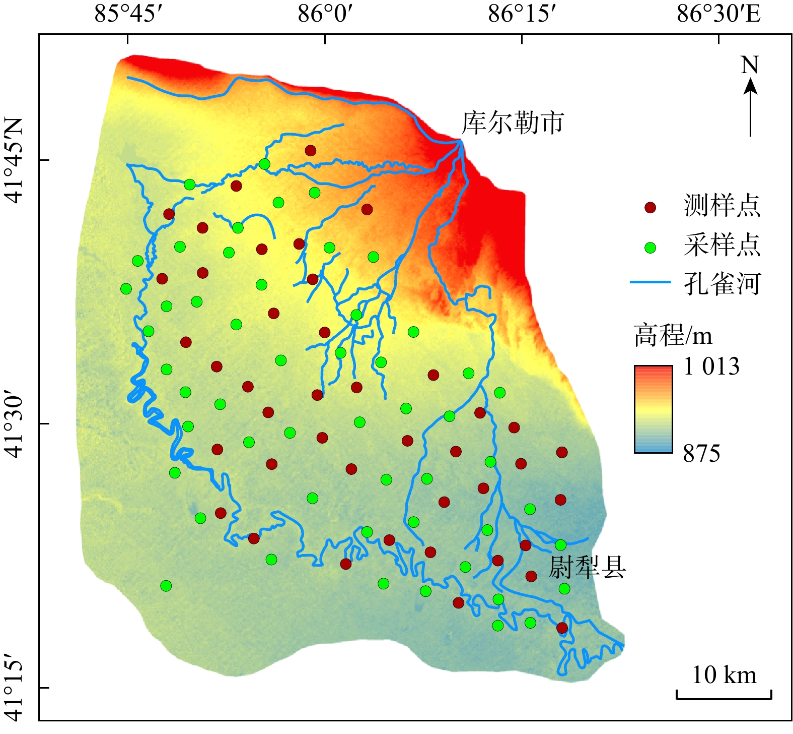
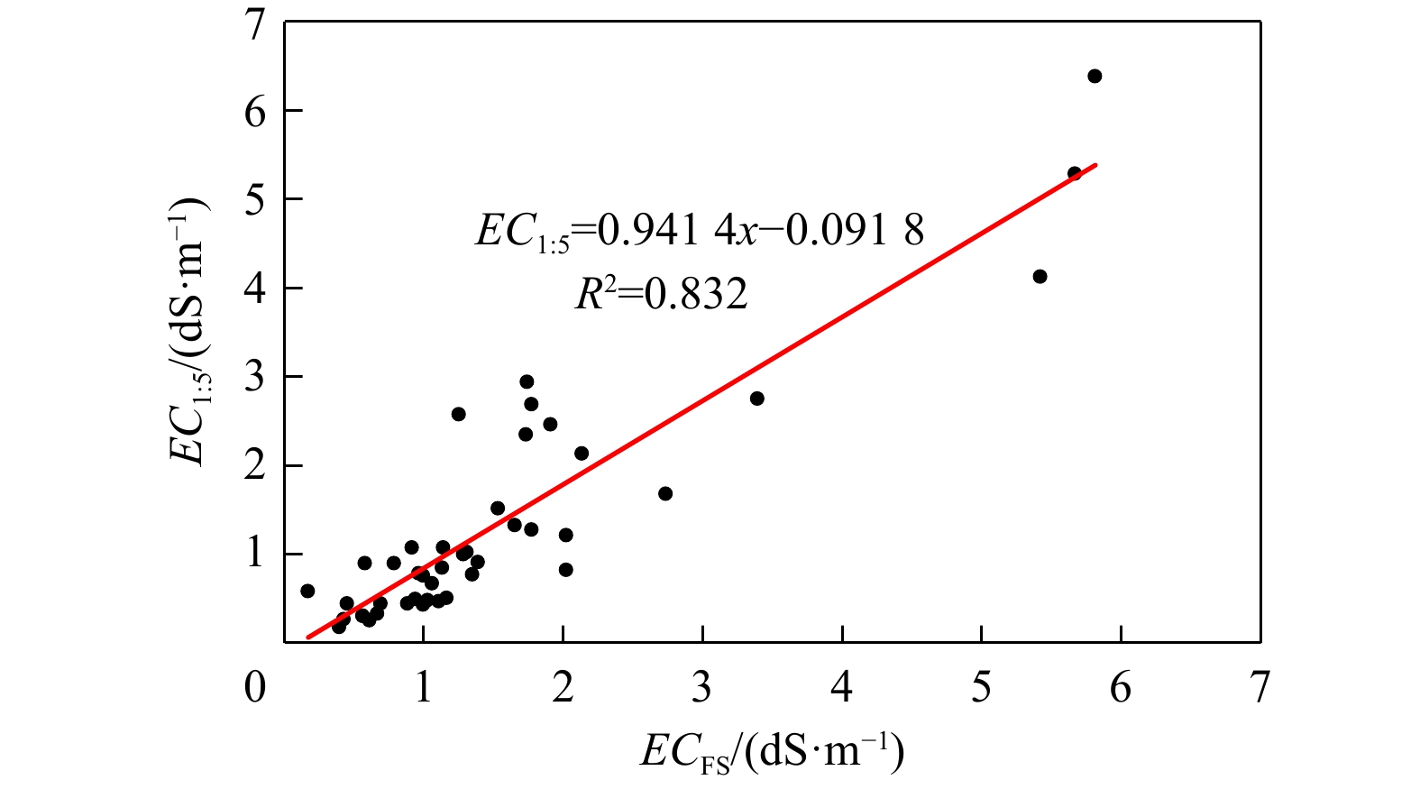
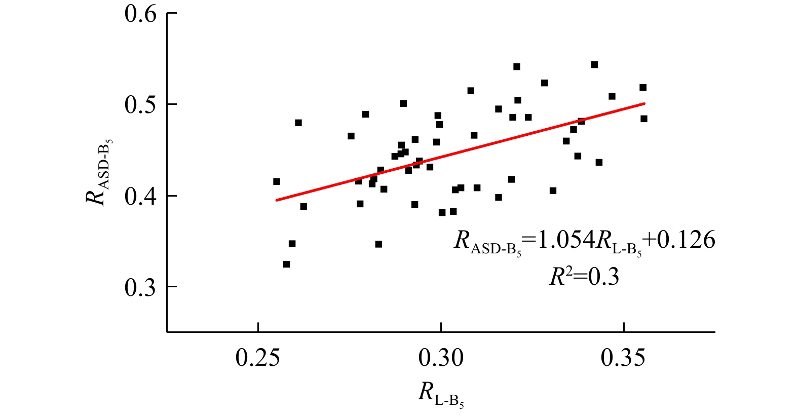
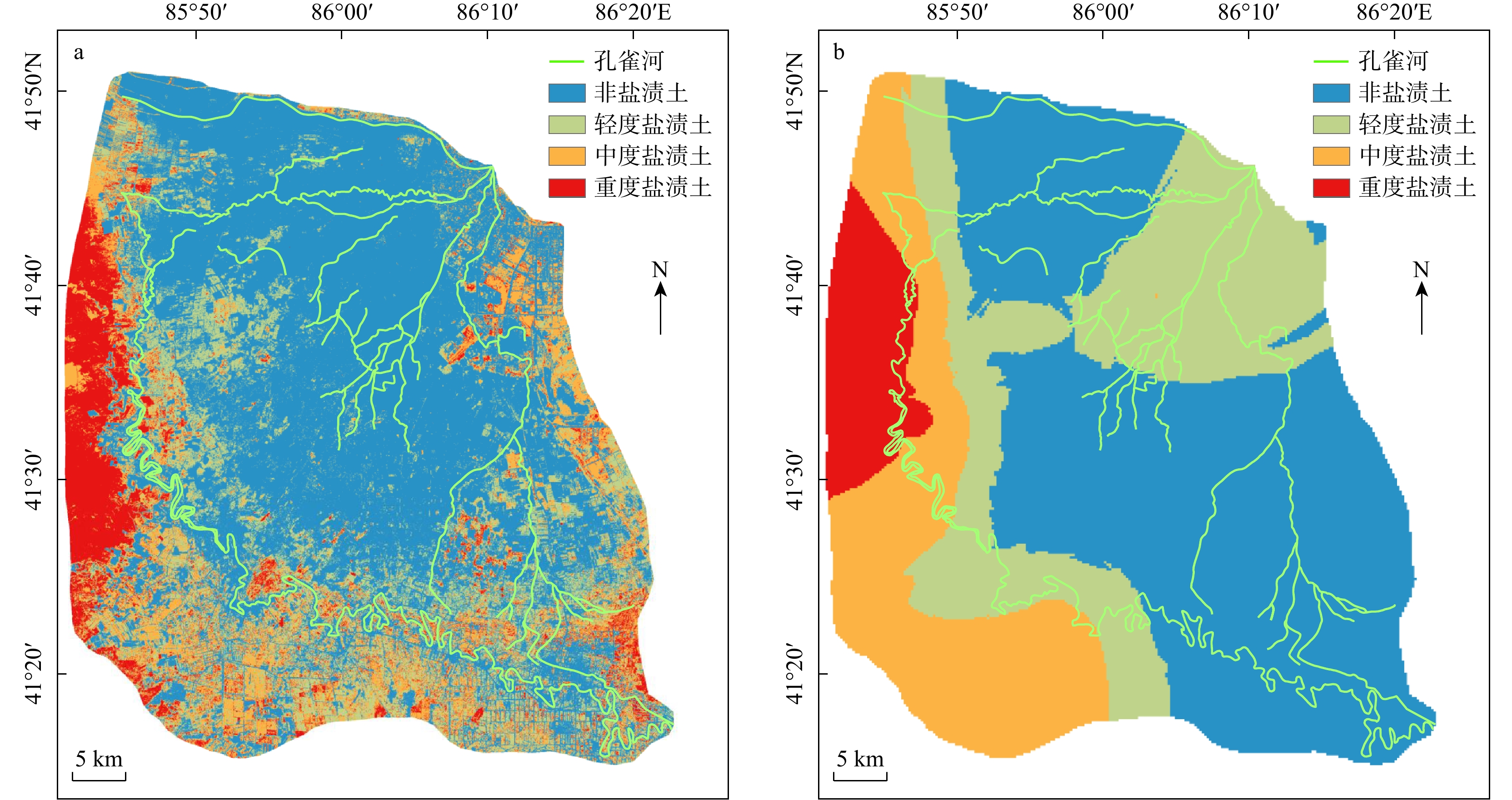
To improve the accuracy of remote sensing inversion of soil salinity in arid regions, the Kongque River irrigation area of the Xinjiang Uygur Autonomous Region was selected as the study area. Soil samples were collected from field survey points. Based on measured soil hyperspectral data acquired with the ASD FieldSpec 4 spectroradiometer, Landsat 8 satellite remote sensing data were calibrated, and the calibrated spectral indices were then used to construct a soil salinity remote sensing inversion model with the random forest algorithm to estimate surface soil salinity in the Kongque River irrigation area.
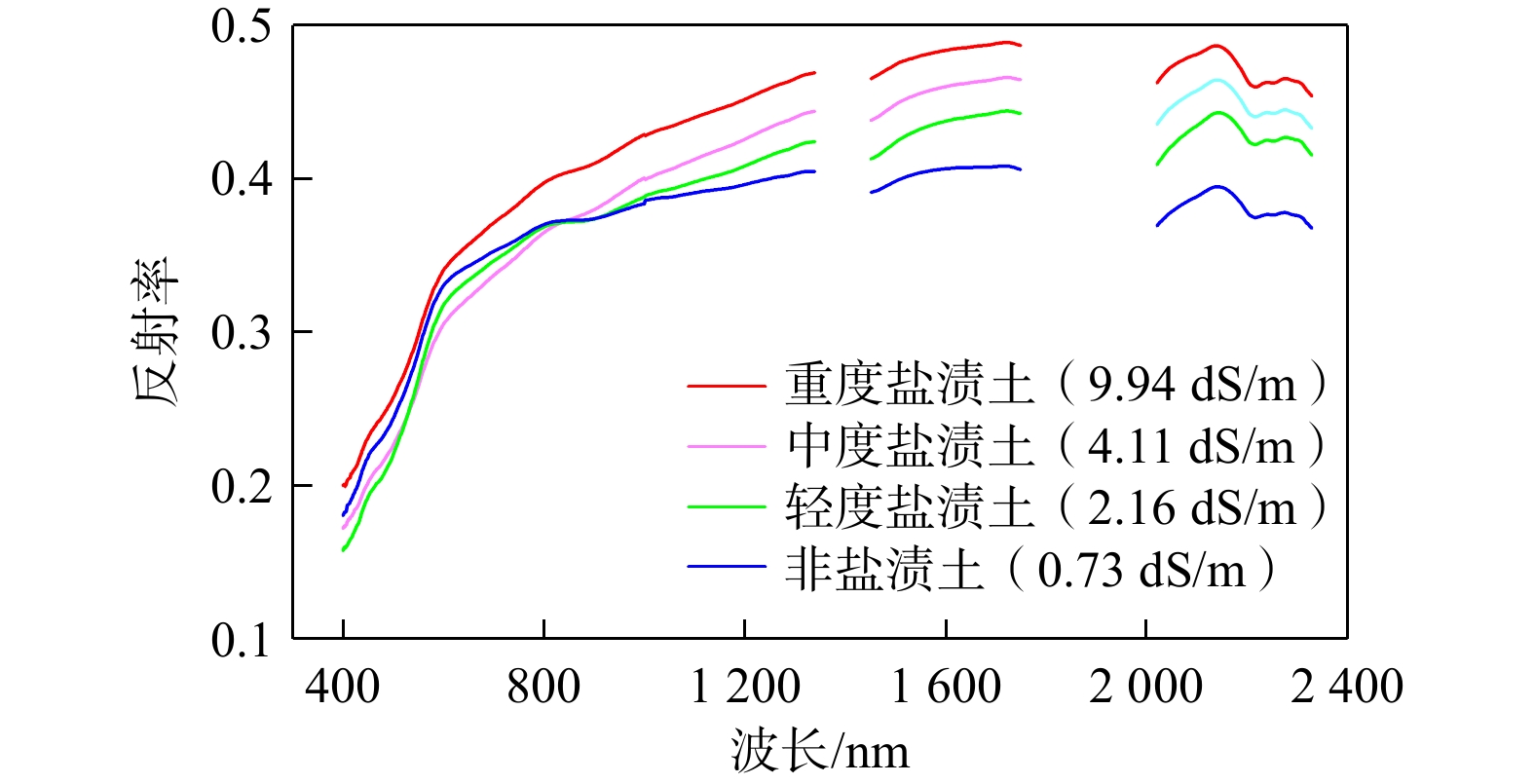
The results showed that soil spectral reflectance increased with increasing salinization degree. After ASD hyperspectral calibration, the correlations between some salinity indices and soil salinity were significantly improved. The random forest was used to construct a remote sensing inversion model for soil salinity. The
The hyperspectrally calibrated random forest inversion model shows good accuracy and can provide reliable technical support for dynamic monitoring of soil salinization in the Kongque River irrigation area and similar arid regions.

| [1] |
李建国, 濮励杰, 朱明, 等. 土壤盐渍化研究现状及未来研究热点[J]. 地理学报, 2012, 67(9): 1233-1245.
LI J G, PU L J, ZHU M, et al. The present situation and hot issues in the salt-affected soil research[J]. Acta Geographica Sinica, 2012, 67(9): 1233-1245. (in Chinese with English abstract
|
| [2] |
SINGH A. Soil salinization management for sustainable development: A review[J]. Journal of Environmental Management, 2021, 277: 111383. doi: 10.1016/j.jenvman.2020.111383
|
| [3] |
杨劲松, 姚荣江, 王相平, 等. 中国盐渍土研究: 历程、现状与展望[J]. 土壤学报, 2022, 59(1): 10-27. doi: 10.11766/trxb202110270578
YANG J S, YAO R J, WANG X P, et al. Research on salt-affected soils in China: History, status quo and prospect[J]. Acta Pedologica Sinica, 2022, 59(1): 10-27. (in Chinese with English abstract doi: 10.11766/trxb202110270578
|
| [4] |
SMITH P, POCH R M, LOBB D A, et al. Status of the world's soils[J]. Annual Review of Environment and Resources, 2024, 49: 73-104. doi: 10.1146/annurev-environ-030323-075629
|
| [5] |
DARVISHZADEH R, ATZBERGER C, SKIDMORE A K, et al. Leaf area index derivation from hyperspectral vegetation indicesand the red edge position[J]. International Journal of Remote Sensing, 2009, 30(23): 6199-6218. doi: 10.1080/01431160902842342
|
| [6] |
刘新, 郝媛媛, 花立民. 石羊河下游民勤盆地土壤盐分空间分异特征[J]. 干旱区研究, 2023, 40(10): 1615-1624. doi: 10.13866/j.azr.2023.10.08
LIU X, HAO Y Y, HUA L M. Spatial differentiation characteristics of soil salinity in Minqin Basin, downstream of Shiyang River, China[J]. Arid Zone Research, 2023, 40(10): 1615-1624. (in Chinese with English abstract doi: 10.13866/j.azr.2023.10.08
|
| [7] |
王敬哲, 丁建丽, 葛翔宇, 等. 基于星地传感技术的土壤盐渍化监测进展与展望[J]. 遥感学报, 2024, 28(9): 2187-2208.
WANG J Z, DING J L, GE X Y, et al. Monitoring soil salinization on the basis of remote sensing and proximal soil sensing: Progress and perspective[J]. National Remote Sensing Bulletin, 2024, 28(9): 2187-2208. (in Chinese with English abstract
|
| [8] |
杨宁, 崔文轩, 张智韬, 等. 无人机多光谱遥感反演不同深度土壤盐分[J]. 农业工程学报, 2020, 36(22): 13-21. doi: 10.11975/j.issn.1002-6819.2020.22.002
YANG N, CUI W X, ZHANG Z T, et al. Soil salinity inversion at different depths using improved spectral index with UAV multispectral remote sensing[J]. Transactions of the Chinese Society of Agricultural Engineering, 2020, 36(22): 13-21. (in Chinese with English abstract doi: 10.11975/j.issn.1002-6819.2020.22.002
|
| [9] |
SHOKRI N, HASSANI A, SAHIMI M. Multi-scale soil salinization dynamics from global to pore scale: A review[J]. Reviews of Geophysics, 2024, 62(4): e2023RG000804. doi: 10.1029/2023RG000804
|
| [10] |
刘福全, 杜崇, 韩旭, 等. 基于3S技术的大庆地区土壤盐渍化时空变化分析[J]. 灌溉排水学报, 2022, 41(5): 132-138. doi: 10.13522/j.cnki.ggps.2021494
LIU F Q, DU C, HAN X, et al. Spatiotemporal variation in soil salinization in Daqing calculated using the 3S technology[J]. Journal of Irrigation and Drainage, 2022, 41(5): 132-138. (in Chinese with English abstract doi: 10.13522/j.cnki.ggps.2021494
|
| [11] |
谭世林, 胡雪菲, 岳胜如. 塔里木河流域绿洲土壤盐分遥感反演模型研究[J]. 测绘与空间地理信息, 2022, 45(6): 78-81. doi: 10.3969/j.issn.1672-5867.2022.06.023
TAN S L, HU X F, YUE S R. Remote sensing retrieval model of soil salinity in oasis of Tarim River Basin[J]. Geomatics & Spatial Information Technology, 2022, 45(6): 78-81. (in Chinese with English abstract doi: 10.3969/j.issn.1672-5867.2022.06.023
|
| [12] |
付萍杰, 补沅坤, 马池杰, 等. 基于GEE的黄河三角洲地区土壤含盐量时空反演[J]. 测绘通报, 2024(11): 13-20. doi: 10.13474/j.cnki.11-2246.2024.1103
FU P J, BU Y K, MA C J, et al. Spatio-temporal inversion of soil salinity in the Yellow River Delta region based on GEE[J]. Bulletin of Surveying and Mapping, 2024(11): 13-20. (in Chinese with English abstract doi: 10.13474/j.cnki.11-2246.2024.1103
|
| [13] |
YE H J, TANG S L, BAI Y, et al. Estimation of sea surface salinity from MODIS-Aqua data in the northern South China Sea[J]. Regional Studies in Marine Science, 2024, 77: 103684. doi: 10.1016/j.rsma.2024.103684
|
| [14] |
HE Y J, YIN H Y, CHEN Y W, et al. Soil salinity estimation based on sentinel-1/2 texture features and machine learning[J]. IEEE Sensors Journal, 2024, 24(9): 15302-15310. doi: 10.1109/JSEN.2024.3377682
|
| [15] |
姚远, 丁建丽, 张芳, 等. 基于高光谱指数和电磁感应技术的区域土壤盐渍化监测模型[J]. 光谱学与光谱分析, 2013, 33(6): 1658-1664.
YAO Y, DING J L, ZHANG F, et al. Research on model of soil salinization monitoring based on hyperspectral index and EM38[J]. Spectroscopy and Spectral Analysis, 2013, 33(6): 1658-1664. (in Chinese with English abstract
|
| [16] |
孙亚楠, 李仙岳, 史海滨, 等. 基于多源数据融合的盐分遥感反演与季节差异性研究[J]. 农业机械学报, 2020, 51(6): 169-180.
SUN Y N, LI X Y, SHI H B, et al. Remote sensing inversion of soil salinity and seasonal difference analysis based on multi-source data fusion[J]. Transactions of the Chinese Society of Agricultural Engineering, 2020, 51(6): 169-180. (in Chinese with English abstract
|
| [17] |
张贤龙, 张飞, 张海威, 等. 基于光谱变换的高光谱指数土壤盐分反演模型优选[J]. 农业工程学报, 2018, 34(1): 110-117. doi: 10.11975/j.issn.1002-6819.2018.01.015
ZHANG X L, ZHANG F, ZHANG H W, et al. Optimization of soil salt inversion model based on spectral transformation from hyperspectral index[J]. Transactions of the Chinese Society of Agricultural Engineering, 2018, 34(1): 110-117. (in Chinese with English abstract doi: 10.11975/j.issn.1002-6819.2018.01.015
|
| [18] |
张孟, 韦玮, 张艳娜, 等. Hyperion高光谱遥感器的在轨自动化定标[J]. 光学学报, 2019, 39(5): 0528002. doi: 10.3788/AOS201939.0528002
ZHANG M, WEI W, ZHANG Y N, et al. On-orbit automated calibration of Hyperion hyperspectral remote sensor[J]. Acta Optica Sinica, 2019, 39(5): 0528002. (in Chinese with English abstract doi: 10.3788/AOS201939.0528002
|
| [19] |
马驰. 基于HJ1A-HSI反演松嫩平原土壤盐分含量[J]. 干旱区研究, 2014, 31(2): 226-230.
MA C. Quantitative retrieval of soil salt content in the Songnen Plain based on HJ1A-HSI images[J]. Arid Zone Research, 2014, 31(2): 226-230. (in Chinese with English abstract
|
| [20] |
THENKABAIL P S, ENCLONA E A, ASHTON M S, et al. Hyperion, IKONOS, ALI, and ETM+ sensors in the study of African rainforests[J]. Remote Sensing of Environment, 2004, 90(1): 23-43. doi: 10.1016/j.rse.2003.11.018
|
| [21] |
KATTENBORN T, MAACK J, FAßNACHT F, et al. Mapping forest biomass from space: Fusion of hyperspectral EO1-Hyperion data and Tandem-X and WorldView-2 canopy height models[J]. International Journal of Applied Earth Observation and Geoinformation, 2015, 35: 359-367. doi: 10.1016/j.jag.2014.10.008
|
| [22] |
厉彦玲, 赵庚星, 常春艳, 等. OLI与HSI影像融合的土壤盐分反演模型[J]. 农业工程学报, 2017, 33(21): 173-180.
LI Y L, ZHAO G X, CHANG C Y, et al. Soil salinity retrieval model based on OLI and HSI image fusion[J]. Transactions of the Chinese Society of Agricultural Engineering, 2017, 33(21): 173-180. (in Chinese with English abstract
|
| [23] |
刘知, 李彦星, 杨波, 等. 山西省中条山中北段遥感示矿信息提取与区块优选[J]. 地质科技通报, 2026, 45(2): 274-292. doi: 10.19509/j.cnki.dzkq.tb20240617
LIU Z, LI Y X, YANG B, et al. Extraction of remote sensing ore-indicating information and block optimization in middle-northern segment of Zhongtiao Mountain, Shanxi Province[J]. Bulletin of Geological Science and Technology, 2026, 45(2): 274-292. (in Chinese with English abstract doi: 10.19509/j.cnki.dzkq.tb20240617
|
| [24] |
孙亚楠, 李仙岳, 史海滨, 等. 基于高光谱数据的盐荒地和耕地土壤盐分遥感反演优化[J]. 农业工程学报, 2022, 38(23): 101-111.
SUN Y N, LI X Y, SHI H B, et al. Optimizing the inversion of soil salt in salinized wasteland using hyperspectral data from remote sensing[J]. Transactions of the Chinese Society of Agricultural Engineering, 2022, 38(23): 101-111. (in Chinese with English abstract
|
| [25] |
周世勋, 尹娟, 王军涛, 等. 灌区土壤含盐量的高光谱估测与空间分布研究[J]. 灌溉排水学报, 2025, 44(2): 72-82. doi: 10.13522/j.cnki.ggps.2024066
ZHOU S X, YIN J, WANG J T, et al. Mapping soil salinity in irrigated areas using hyperspectral UAV imagery[J]. Journal of Irrigation and Drainage, 2025, 44(2): 72-82. (in Chinese with English abstract doi: 10.13522/j.cnki.ggps.2024066
|
| [26] |
张茗惠, 张峻华, 盛统民, 等. 微咸水膜下滴灌棉花根系时空分布规律及三维动态生长模拟[J]. 地质科技通报, 2026, 45(1): 279-290. doi: 10.19509/j.cnki.dzkq.tb20240155
ZHANG M H, ZHANG J H, SHENG T M, et al. Spatial-temporal distribution patterns of cotton root system under brackish water mulched drip irrigation and three-dimensional dynamic growth simulation[J]. Bulletin of Geological Science and Technology, 2026, 45(1): 279-290. (in Chinese with English abstract doi: 10.19509/j.cnki.dzkq.tb20240155
|
| [27] |
WICKE B, SMEETS E, DORNBURG V, et al. The global technical and economic potential of bioenergy from salt-affected soils[J]. Energy & Environmental Science, 2011, 4(8): 2669-2681. doi: 10.1039/C1EE01029H
|
| [28] |
曹肖奕, 丁建丽, 葛翔宇, 等. 基于不同卫星光谱模拟的土壤电导率估算研究[J]. 干旱区地理, 2020, 43(1): 172-181. doi: 10.12118/j.issn.1000-6060.2020.01.20
CAO X Y, DING J L, GE X Y, et al. Estimation of soil conductivity based on spectral simulation of different satellites[J]. Arid Land Geography, 2020, 43(1): 172-181. (in Chinese with English abstract doi: 10.12118/j.issn.1000-6060.2020.01.20
|
| [29] |
WU D, JIA K L, ZHANG X D, et al. Remote sensing inversion for simulation of soil salinization based on hyperspectral data and ground analysis in Yinchuan, China[J]. Natural Resources Research, 2021, 30(6): 4641-4656.
|
| [30] |
KHAN N M, RASTOSKUEV V V, SATO Y, et al. Assessment of hydrosaline land degradation by using a simple approach of remote sensing indicators[J]. Agricultural Water Management, 2005, 77(1/2/3): 96-109. doi: 10.1016/j.agwat.2004.09.038
|
| [31] |
TRIKI FOURATI H, BOUAZIZ M, BENZINA M, et al. Modeling of soil salinity within a semi-arid region using spectral analysis[J]. Arabian Journal of Geosciences, 2015, 8(12): 11175-11182. doi: 10.1007/s12517-015-2004-3
|
| [32] |
姚志华, 陈俊英, 张智韬, 等. 覆膜对无人机多光谱遥感反演土壤含盐量精度的影响[J]. 农业工程学报, 2019, 35(19): 89-97.
YAO Z H, CHEN J Y, ZHANG Z T, et al. Effect of plastic film mulching on soil salinity inversion by using UAV multispectral remote sensing[J]. Transactions of the Chinese Society of Agricultural Engineering, 2019, 35(19): 89-97. (in Chinese with English abstract
|
| [33] |
EL KADER DOUAOUI A, NICOLAS H, WALTER C. Detecting salinity hazards within a semiarid context by means of combining soil and remote-sensing data[J]. Geoderma, 2006, 134(1/2): 217-230. doi: 10.1016/j.geoderma.2005.10.009
|
| [34] |
SCUDIERO E, SKAGGS T H, CORWIN D L. Regional scale soil salinity evaluation using Landsat 7, western San Joaquin Valley, California, USA[J]. Geoderma Regional, 2014, 2/3: 82-90.
|
| [35] |
张智韬, 杜瑜燕, 劳聪聪, 等. 基于雷达遥感的不同深度土壤含盐量反演模型[J]. 农业机械学报, 2020, 51(10): 243-251. doi: 10.6041/j.issn.1000-1298.2020.10.027
ZHANG Z T, DU Y Y, LAO C C, et al. Inversion model of soil salt content in different depths based on radar remote sensing[J]. Transactions of the Chinese Society for Agricultural Machinery, 2020, 51(10): 243-251. (in Chinese with English abstract doi: 10.6041/j.issn.1000-1298.2020.10.027
|
| [36] |
CHO K H, BEON M S, JEONG J C. Dynamics of soil salinity and vegetation in a reclaimed area in Saemangeum, Republic of Korea[J]. Geoderma, 2018, 321: 42-51. doi: 10.1016/j.geoderma.2018.01.031
|
| [37] |
冯娟, 丁建丽, 杨爱霞, 等. 干旱区土壤盐渍化信息遥感建模[J]. 干旱地区农业研究, 2018, 36(1): 266-273. doi: 10.7606/j.issn.1000-7601.2018.01.39
FENG J, DING J L, YANG A X, et al. Remote sensing modeling of soil salinization information in arid areas[J]. Agricultural Research in the Arid Areas, 2018, 36(1): 266-273. (in Chinese with English abstract doi: 10.7606/j.issn.1000-7601.2018.01.39
|
| [38] |
奚雪, 赵庚星, 高鹏, 等. 基于Sentinel卫星及无人机多光谱的滨海冬小麦种植区土壤盐分反演研究: 以黄三角垦利区为例[J]. 中国农业科学, 2020, 53(24): 5005-5016. doi: 10.3864/j.issn.0578-1752.2020.24.004
XI X, ZHAO G X, GAO P, et al. Inversion of soil salinity in coastal winter wheat growing area based on sentinel satellite and unmanned aerial vehicle multi-spectrum: A case study in Kenli district of the Yellow River Delta[J]. Scientia Agricultura Sinica, 2020, 53(24): 5005-5016. (in Chinese with English abstract doi: 10.3864/j.issn.0578-1752.2020.24.004
|
| [39] |
陈红艳, 赵庚星, 陈敬春, 等. 基于改进植被指数的黄河口区盐渍土盐分遥感反演[J]. 农业工程学报, 2015, 31(5): 107-114. doi: 10.3969/j.issn.1002-6819.2015.05.016
CHEN H Y, ZHAO G X, CHEN J C, et al. Remote sensing inversion of saline soil salinity based on modified vegetation index in estuary area of Yellow River[J]. Transactions of the Chinese Society of Agricultural Engineering, 2015, 31(5): 107-114. (in Chinese with English abstract doi: 10.3969/j.issn.1002-6819.2015.05.016
|
| [40] |
GITELSON A A, KAUFMAN Y J, MERZLYAK M N. Use of a green channel in remote sensing of global vegetation from EOS-MODIS[J]. Remote Sensing of Environment, 1996, 58(3): 289-298. doi: 10.1016/S0034-4257(96)00072-7
|
| [41] |
QI Z W, XIAO C L, WANG G, et al. Study on ecological threshold of groundwater in typical salinization area of Qian'an County[J]. Water, 2021, 13(6): 856. doi: 10.3390/w13060856
|
| [42] |
BREIMAN L. Random forests[J]. Machine Learning, 2001, 45(1): 5-32. doi: 10.1023/A:1010933404324
|
| [43] |
王怡婧, 贾萍萍, 陈睿华, 等. 多源遥感对宁夏干湿季土壤含盐量敏感性分析与定量反演[J]. 生态学杂志, 2023, 42(9): 2286-2295. doi: 10.13292/j.1000-4890.202309.006
WANG Y J, JIA P P, CHEN R H, et al. Sensitivity analysis and quantitative inversion of multi-source remote sensing to soil salt content in dry and wet seasons in Ningxia[J]. Chinese Journal of Ecology, 2023, 42(9): 2286-2295. (in Chinese with English abstract doi: 10.13292/j.1000-4890.202309.006
|
| [44] |
王飞, 丁建丽, 魏阳, 等. 基于Landsat系列数据的盐分指数和植被指数对土壤盐度变异性的响应分析: 以新疆天山南北典型绿洲为例[J]. 生态学报, 2017, 37(15): 5007-5022.
WANG F, DING J L, WEI Y, et al. Sensitivity analysis of soil salinity and vegetation indices to detect soil salinity variation by using Landsat series images: Applications in different oases in Xinjiang, China[J]. Acta Ecologica Sinica, 2017, 37(15): 5007-5022. (in Chinese with English abstract
|
| [45] |
谷海斌, 王泽, 武红旗, 等. 不同开垦年限土壤养分和盐分时空分布特征研究[J]. 干旱地区农业研究, 2016, 34(3): 8-15. doi: 10.7606/j.issn.1000-7601.2016.03.02
GU H B, WANG Z, WU H Q, et al. Research on temporal and spatial distribution characteristics of soil nutrient and salt under different reclamation years[J]. Agricultural Research in the Arid Areas, 2016, 34(3): 8-15. (in Chinese with English abstract doi: 10.7606/j.issn.1000-7601.2016.03.02
|
| [46] |
张雪, 陈耀轩, 张盼, 等. 孔雀河流域农业灌区土壤盐分空间分布及变异特征[J]. 土壤, 2016, 48(6): 1223-1228. doi: 10.13758/j.cnki.tr.2016.06.023
ZHANG X, CHEN Y X, ZHANG P, et al. Soil salinity spatial distribution and variation characteristics in irrigated land of Kongque River Basin[J]. Soils, 2016, 48(6): 1223-1228. (in Chinese with English abstract doi: 10.13758/j.cnki.tr.2016.06.023
|
Supported by:
Beijing Renhe Information Technology Co., Ltd.


 Submission System

 DownLoad: