| Citation: | Sun Xinyao, Wang Ping, Zhang Hong, Guo Yujie, Guo Fei. Applications status and prospects for using unmanned aerial vehicle in sedimentology[J]. Bulletin of Geological Science and Technology, 2023, 42(1): 407-419. doi: 10.19509/j.cnki.dzkq.2022.0145

|
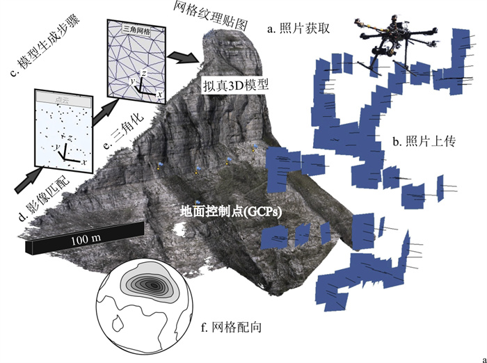
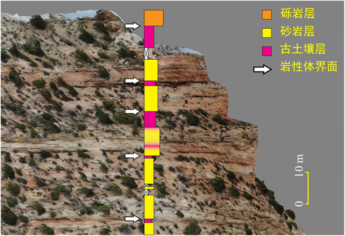
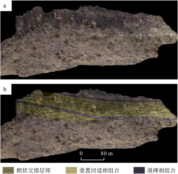
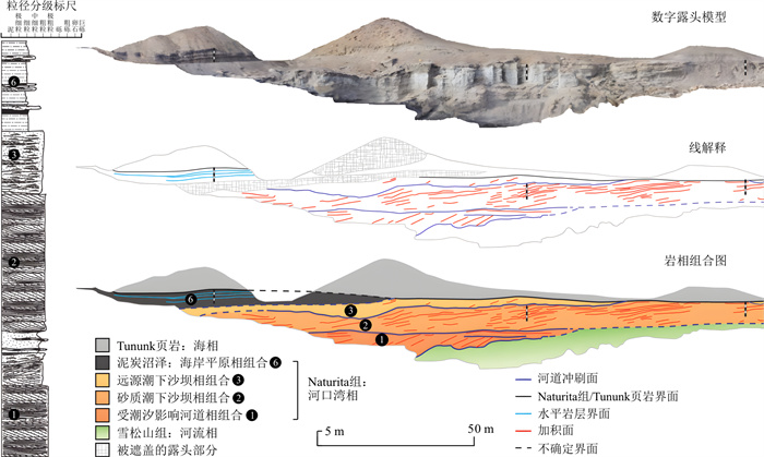
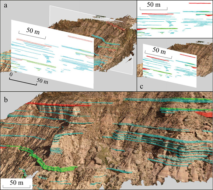
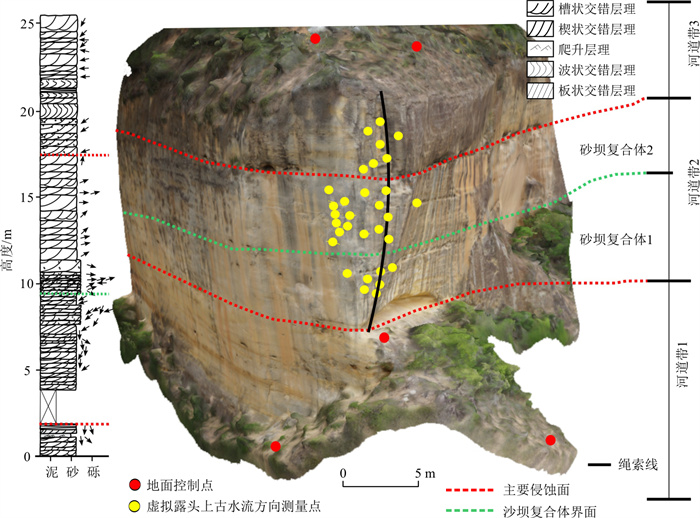
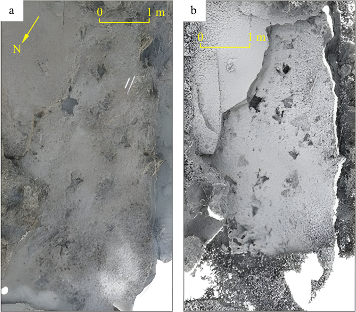
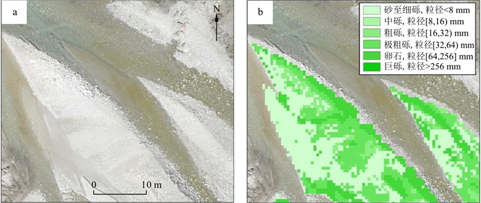
The unmanned aerial vehicle (UAV) is an important tool for acquiring digital images of the surface and collecting samples. Recently, it has been becoming an emerging research tool in sedimentology, changing the paradigm of sedimentology.However, UAV-based sedimentological research in China is still in its infancy. This paper reviews the recently important applications of UAVs in sedimentology, discusses critical technical backgrounds and existing problems involved, and summarizes as well as prospects for future applications of UAVs in sedimentology to provide references for subsequent research.Software and hardware requirements for applications of UAVs in sedimentology and typical case studies are reviewed from three aspects: 3D digital reconstruction of sedimentary outcrops, extraction of high-resolution sedimentary textures and structure features, and UAV-assisted sample collection. The use of UAV photogrammetry to construct digital outcrop models facilitates the observation of geometry, sedimentary facies, and facies associations for sedimentary outcrops from multiple spatial scales and perspectives. Combined with professional software for digital outcrop model interpretations, it allows for remote and efficient extractions of sedimentary textures and structure features such as grain size, cross-bedding, and bioglyph on large spatial scales. UAV-based digital outcrop models can also be applied to field practice teaching in sedimentology in the future. Also, UAVs can be modified to assist in collecting sediment samples like ice cores. The application of the UAV technology in sedimentological research has the advantages of low cost and high efficiency, ensuring the timeliness and continuity of data, and increasing safety in fieldwork. However, UAV technology also has disadvantages in data repeatability, point cloud processing, and image or model quality. Further improvements can be made in the future with the help of artificial intelligence and by developing standard specifications for UAV image acquisition and processing flow.

| [1] |
Jordan B R. A bird's-eye view of geology: The use of micro drones/UAVs in geologic fieldwork and education[J]. GSA Today, 2015, 25(7): 50-52.
|
| [2] |
Pavlis T L, Mason K A. The new world of 3D geologic mapping[J]. GSA Today, 2017, 27(9): 4-10.
|
| [3] |
Gonzaga L, Veronez M R, Alves D N, et al. MOSIS—Multi-outcrop sharing & interpretation system[C]//Anon. 2017 IEEE International Geoscience and Remote Sensing Symposium (IGARSS). Fort Worth, TX: IEEE, 2017: 5209-5212.
|
| [4] |
Bellian J A, Kerans C, Jennette D C. Digital outcrop models: Applications of terrestrial scanning lidar technology in stratigraphic modeling[J]. Journal of Sedimentary Research, 2005, 75(2): 166-176. doi: 10.2110/jsr.2005.013
|
| [5] |
Harrald J E G, Coe A L, Thomas R M, et al. Use of drones to analyse sedimentary successions exposed in the foreshore[J]. Proceedings of the Geologists' Association, 2021, 132(3): 253-268. doi: 10.1016/j.pgeola.2021.02.001
|
| [6] |
Siebert S, Teizer J. Mobile 3D mapping for surveying earthwork projects using an Unmanned Aerial Vehicle (UAV) system[J]. Automation in Construction, 2014, 41: 1-14. doi: 10.1016/j.autcon.2014.01.004
|
| [7] |
Meek S R, Carrapa B, DeCelles P G. Recognizing allogenic controls on the stratigraphic architecture of ancient alluvial fans in the western US[J]. Frontiers in Earth Science, 2020, 8: 215. doi: 10.3389/feart.2020.00215
|
| [8] |
高莎, 袁希平, 甘淑, 等. 基于无人机成像点云的禄丰恐龙谷南缘环状地貌空间特征探测实验分析[J]. 地质科技通报, 2021, 40(6): 283-292. doi: 10.19509/j.cnki.dzkq.2021.0628
Gao S, Yuan X P, Gan S, et al. Experimental analysis of spatial feature detection of the ring geomorphology at the south edge of Lufeng Dinosaur Valley based on UAV imaging point cloud[J]. Bulletin of Geological Science and Technology, 2021, 40(6): 283-292(in Chinese with English abstract). doi: 10.19509/j.cnki.dzkq.2021.0628
|
| [9] |
Corradetti A, Tavani S, Parente M, et al. Distribution and arrest of vertical through-going joints in a seismic-scale carbonate platform exposure (Sorrento peninsula, Italy): Insights from integrating field survey and digital outcrop model[J]. Journal of Structural Geology, 2018, 108: 121-136. doi: 10.1016/j.jsg.2017.09.009
|
| [10] |
孙姣姣, 王琦, 郑洁, 等. 基于DOM成果的航测软件对比分析[J]. 测绘与空间地理信息, 2021, 44(8): 71-74. https://www.cnki.com.cn/Article/CJFDTOTAL-DBCH202108017.htm
Sun J J, Wang Q, Zheng J, et al. Comparative analysis of aerial survey software based on DOM results[J]. Geomatics & Spatial Information Technology, 2021, 44(8): 71-74(in Chinese with English abstract). https://www.cnki.com.cn/Article/CJFDTOTAL-DBCH202108017.htm
|
| [11] |
Aliyuda K, Howell J, Usman M B, et al. Depositional variability of an ancient distributive fluvial system: The upper member of the Lower Cretaceous Bima Formation, northern Benue Trough, Nigeria[J]. Journal of African Earth Sciences, 2019, 159: 103600. doi: 10.1016/j.jafrearsci.2019.103600
|
| [12] |
Phillips S P, Howell J A, Hartley A J, et al. Tidal estuarine deposits of the transgressive Naturita Formation (Dakota Sandstone): San Rafael Swell, Utah, U.S.A. [J]. Journal of Sedimentary Research, 2020, 90(8): 777-795. doi: 10.2110/jsr.2020.51
|
| [13] |
Buckley S J, Ringdal K, Naumann N, et al. LIME: Software for 3-D visualization, interpretation, and communication of virtual geoscience models[J]. Geosphere, 2019, 15(1): 222-235. doi: 10.1130/GES02002.1
|
| [14] |
Freitas B T, Silva L H G, Almeida R P, et al. Cross‐strata palaeocurrent analysis using virtual outcrops[J]. Sedimentology, 2021, 68(6): 2397-2421. doi: 10.1111/sed.12855
|
| [15] |
Romilio A, Hacker J M, Zlot R, et al. A multidisciplinary approach to digital mapping of dinosaurian tracksites in the Lower Cretaceous (Valanginian-Barremian) Broome Sandstone of the Dampier Peninsula, western Australia[J]. Peer J, 2017, 5: e3013. doi: 10.7717/peerj.3013
|
| [16] |
Woodget A S, Austrums R. Subaerial gravel size measurement using topographic data derived from a UAV-SfM approach: Subaerial gravel size measurement using topographic UAV-SfM data[J]. Earth Surface Processes and Landforms, 2017, 42(9): 1434-1443. doi: 10.1002/esp.4139
|
| [17] |
Vázquez-Tarrío D, Borgniet L, Liébault F, et al. Using UAS optical imagery and SfM photogrammetry to characterize the surface grain size of gravel bars in a braided river (Vénéon River, French Alps)[J]. Geomorphology, 2017, 285: 94-105. doi: 10.1016/j.geomorph.2017.01.039
|
| [18] |
Smith Z D, Maxwell D J. Constructing vertical measurement logs using UAV-Based photogrammetry: Applications for multiscale high-resolution analysis of coarse-grained volcaniclastic stratigraphy[J]. Journal of Volcanology and Geothermal Research, 2021, 409: 107122. doi: 10.1016/j.jvolgeores.2020.107122
|
| [19] |
Mori T, Hashimoto T, Terada A, et al. Volcanic plume measurements using a UAV for the 2014 Mt. Ontake eruption[J]. Earth, Planets and Space, 2016, 68(1): 1-18. doi: 10.1186/s40623-015-0369-x
|
| [20] |
Carlson D F, Pasma J, Jacobsen M E, et al. Retrieval of ice samples using the ice drone[J]. Frontiers in Earth Science, 2019, 7: 287. doi: 10.3389/feart.2019.00287
|
| [21] |
Bemis S P, Micklethwaite S, Turner D, et al. Ground-based and UAV-based photogrammetry: A multi-scale, high-resolution mapping tool for structural geology and paleoseismology[J]. Journal of Structural Geology, 2014, 69: 163-178. doi: 10.1016/j.jsg.2014.10.007
|
| [22] |
周银邦, 赵淑霞, 张庆新, 等. 露头类比方法在地下储层建模中的应用进展[J]. 地质科技情报, 2017, 36(1): 247-254. https://www.cnki.com.cn/Article/CJFDTOTAL-DZKQ201701033.htm
Zhou Y B, Zhao S X, Zhang Q X, et al. Progress of the outcrop analogy method application in the modeling of underground reservoirs[J]. Geological Science and Technology Information, 2017, 36(1): 247-254(in Chinese with English abstract). https://www.cnki.com.cn/Article/CJFDTOTAL-DZKQ201701033.htm
|
| [23] |
Pitman S J, Hart D E, Katurji M H. Application of UAV techniques to expand beach research possibilities: A case study of coarse clastic beach cusps[J]. Continental Shelf Research, 2019, 184: 44-53. doi: 10.1016/j.csr.2019.07.008
|
| [24] |
万剑华, 王朝, 刘善伟, 等. 倾斜摄影测量构建地质数字露头[J]. 地质科技情报, 2019, 38(1): 258-264. https://www.cnki.com.cn/Article/CJFDTOTAL-DZKQ201901029.htm
Wan J H, Wang C, Liu S W, et al. Reconstructing geological digital outcrops with oblique photogrammetry[J]. Geological Science and Technology Information, 2019, 38(1): 258-264(in Chinese with English abstract). https://www.cnki.com.cn/Article/CJFDTOTAL-DZKQ201901029.htm
|
| [25] |
吕权儒, 曾斌, 孟小军, 等. 基于无人机倾斜摄影技术的崩塌隐患早期识别及影响区划分方法[J]. 地质科技通报, 2021, 40(6): 313-325. doi: 10.19509/j.cnki.dzkq.2021.0631
Lü Q R, Zeng B, Meng X J, et al. Early identification and influence range division method of collapse hazards based on UAV oblique photography technology[J]. Bulletin of Geological Science and Technology, 2021, 40(6): 313-325(in Chinese with English abstract). doi: 10.19509/j.cnki.dzkq.2021.0631
|
| [26] |
Mezghani M M, Fallatah M I, AbuBshait A A. From drone-based remote sensing to digital outcrop modeling: Integrated workflow for quantitative outcrop interpretation[J]. Journal of Remote Sensing & GIS, 2018, 7(2): 1-7.
|
| [27] |
Nesbit P R, Durkin P R, Hugenholtz C H, et al. 3-D stratigraphic mapping using a digital outcrop model derived from UAV images and structure-from-motion photogrammetry[J]. Geosphere, 2018, 14(6): 2469-2486.
|
| [28] |
Liao Y, Mohammadi M E, Wood R L. Deep learning classification of 2D orthomosaic images and 3D point clouds for post-event structural damage assessment[J]. Drones, 2020, 4(2): 24.
|
| [29] |
Khan A I, Al-Mulla Y. Unmanned aerial vehicle in the machine learning environment[J]. Procedia Computer Science, 2019, 160: 46-53.
|
| [30] |
Singh K K, Frazier A E. A meta-analysis and review of unmanned aircraft system (UAS) imagery for terrestrial applications[J]. International Journal of Remote Sensing, 2018, 39(15/16): 5078-5098.
|
| [31] |
James M R, Chandler J H, Eltner A, et al. Guidelines on the use of structure‐from‐motion photogrammetry in geomorphic research[J]. Earth Surface Processes and Landforms, 2019, 44(10): 2081-2084.
|
Copyright © 2010Editorial Department of Bulletin of Geological Science and Technology

Supported by:
Beijing Renhe Information Technology Co., Ltd.


 DownLoad: