投审稿入口


Application analysis of UAV front-end intelligence in geological element interpretation
-
摘要:目的
中小型无人机在地质智能化应用中发挥着越来越重要的作用,但机载硬件算力有限、续航电量不足等现实瓶颈,严重制约智能分割模型在无人机平台的嵌入式部署。针对该问题,本研究将原生多核轻量化卷积网络 UltraLightUNet 应用于东昆仑高原复杂地质要素语义分割任务,探究无人机前端智能场景下轻量化模型的地质解译性能。该模型不同于剪枝、量化等事后压缩式轻量化手段以及现有网络单核卷积、弱注意力的设计思路,依靠 MKIR/MKIRA 多内核模块,在较低计算开销下强化多尺度地质特征提取能力。
方法基于东昆仑地区包含 13 类地质要素的 Landsat-8 遥感数据集,采用 ComboLoss 组合损失函数训练模型;将 UltraLightUNet 与 U-Net、DeepLabv3plus 等大规模网络,以及 MobileNetV3、Fast-SCNN 等主流轻量化模型开展对比实验,从参数量、浮点运算量(FLOPs)与分割精度三个维度综合评估模型在无人机前端部署条件下的实用性。
结果实验结果显示,UltraLightUNet 参数量仅 0.32 M,浮点运算量仅 0.77 G;参数量与运算开销分别降至 U-Net、DeepLabv3plus 的 1/92~1/466、1/10~1/230;模型平均像素准确率(mPA)为 62.75%,平均交并比(mIoU)为 40.82%,F1分数为 55.68%;相较于 SegNet,mPA、mIoU、F1分数分别提升 4.14%、6.98%、6.92%。
结论UltraLight-UNet 的参数量与计算开销低于 MobileNetV3、Fast-SCNN 等轻量化网络,针对地质影像纹理微弱、地物边界模糊的特点优化特征表达,可为无人机地质解译提供可直接前端部署的微小模型方案。该模型对比大尺度多模态 SOTA 网络仍存在精度提升空间,但可为无人机地质装备智能化部署提供实验依据,也为地质任务定制轻量化网络奠定研究基础。
-
关键词:
- 无人机前端智能 /
- 轻量化模型 /
- 地质要素解译 /
- UltraLightUNet微小模型
Abstract:ObjectiveSmall- and medium-sized unmanned aerial vehicles (UAVs) are playing an increasingly important role in intelligent geological applications. Nevertheless, practical bottlenecks, such as limited onboard computing resources and insufficient battery capacity, severely constrain the embedded deployment of intelligent segmentation models on UAV platforms. Complex orogenic regions such as the Eastern Kunlun are characterized by diverse lithology, blurred geological boundaries, and high intra-class spectral similarity, posing additional challenges for geological element interpretation using lightweight models. To address this issue, this study applies the natively designed multi-kernel lightweight network UltraLight-UNet to semantic segmentation of complex geological features in the Eastern Kunlun Plateau, exploring the geological interpretation performance of lightweight models in UAV front-end embedded intelligent scenarios. Unlike conventional lightweight strategies that obtain compact networks via post-processing compression techniques including pruning and quantization, as well as existing networks that rely on single-kernel convolutions and weak attention mechanisms, this model leverages multi-kernel inverted residual (MKIR) and multi-kernel inverted residual attention (MKIRA) modules to enhance multi-scale geological feature extraction under relatively low computational overhead.
MethodsThe Landsat-8 remote sensing dataset of the Eastern Kunlun region containing a total of 4 199 image samples covering 13 geological classes was divided into training, validation, and test subsets at an approximate ratio of 7:2:1. The ComboLoss composite loss function combining cross-entropy loss, Dice loss, and boundary loss was adopted for model training. This study conducted comprehensive comparative experiments between UltraLight-UNet and large-scale segmentation models (U-Net, DeepLabv3plus), as well as mainstream lightweight networks including MobileNetV3 and Fast-SCNN. Model performance was evaluated quantitatively from three dimensions: model parameters, floating-point operations (FLOPs), and geological-element interpretation accuracy, to verify the model’s practicality for UAV front-end deployment.
ResultsExperimental results demonstrated that UltraLight-UNet only had 0.32 M parameters and 0.77 G FLOPs. Its parameter quantity and computational overhead dropped to 1/92–1/466 and 1/10–1/230 of those of U-Net and DeepLabv3plus, respectively. The model achieved a mean pixel accuracy (mPA) of 62.75%, a mean intersection over union (mIoU) of 40.82%, and an F1-score of 55.68%. Compared with SegNet, mPA, mIoU, and F1-score increased by 4.14%, 6.98%, and 6.92%, respectively.
ConclusionUltraLight-UNet has lower parameter quantity and computational overhead than representative lightweight networks such as MobileNetV3 and Fast-SCNN. It improves feature representation capability for remote sensing scenes with weak geological textures and ambiguous lithological boundaries, providing a feasible micro-model solution for direct front-end deployment in UAV geological interpretation tasks. Although the model still has room for accuracy improvements compared with large-scale multimodal state-of-the-art (SOTA) networks, it provides solid experimental evidence for the intelligent deployment of UAV geological survey equipment. It also lays a research foundation for developing task-oriented lightweight networks targeting complex geological interpretation scenarios.
-
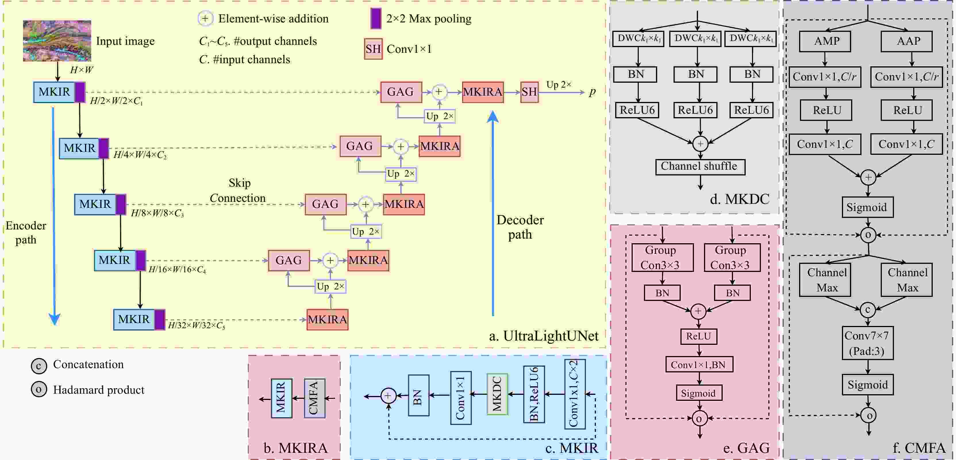
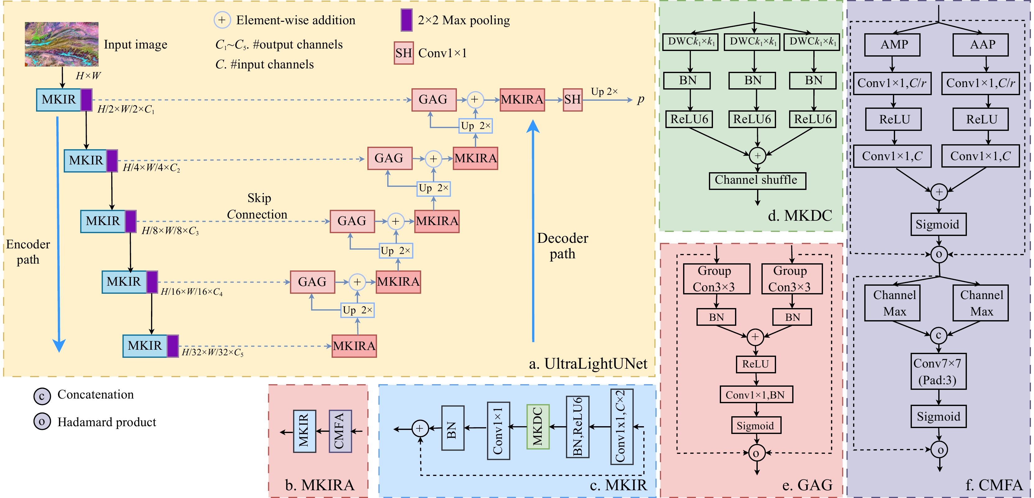
图 1 UltraLightUNet模型整体架构(a)与组件细节(b~f)(据文献[27])
element-wise addition为逐元素相加;#output channels为输出通道数;C1~C5为各编码阶段输出通道数;C为输入通道数;Input Image为输入影像;H为图像高度;W为图像宽度;MKIR为多核反向残差模块;MKIRA为多核反向残差注意力;GAG为分组注意力门;MKDC为多核并行深度卷积;CMFA为卷积多焦点注意力;2×2 Max Pooling为2×2最大池化下采样;Encoder Path为编码器路径;Skip Connection为跳跃连接;Decoder Path为解码器路径;Up 2×为2倍双线性上采样;SH为分割头;p为输出分割概率;DWCk1×k1为深度卷积(k1×k1,k1∈{1,3,5});BN为批量归一化;ReLU6,ReLU,Sigmoid均为激活函数;Channel Shuffle为通道洗牌;Conv1×1为1×1逐点卷积;r为通道压缩率;Conv7×7(Pad:3)为7×7大核卷积;AMP/AAP为自适应最大池化;AAP为自适应平均池化;Channel Max通道最大池化;Channel Avg为通道平均池化;Concatenation为通道拼接;Hadamard Product为哈达玛积;下同
Figure 1. Overall architecture of UltraLightUNet model (a) and details of its components (b-f)

图 2 α,β,γ 3个超参数敏感性分析实验
mIoU为平均交并比;Precision为精确率;α,β,γ分别为交叉熵、Dice 和边界损失权重
Figure 2. Sensitivity analysis experiments of three hyperparameters: α, β, and γ
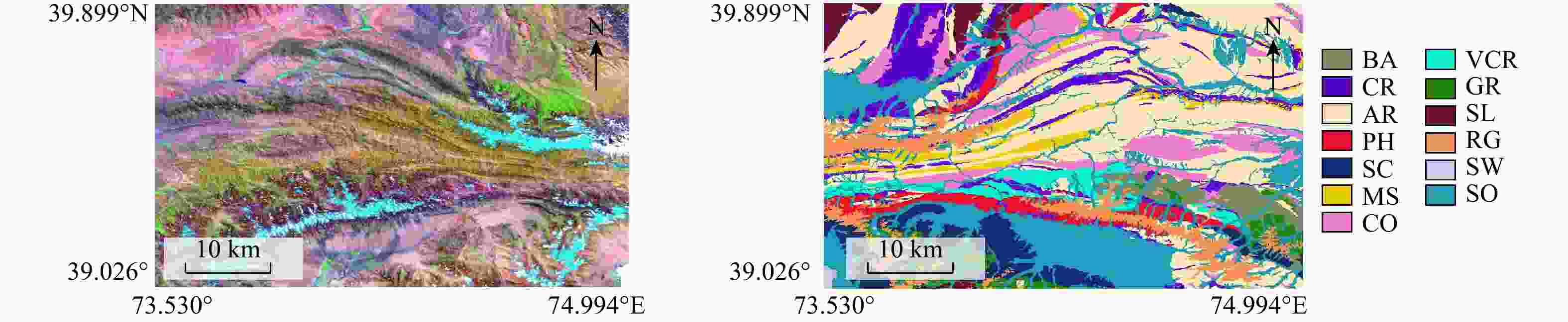
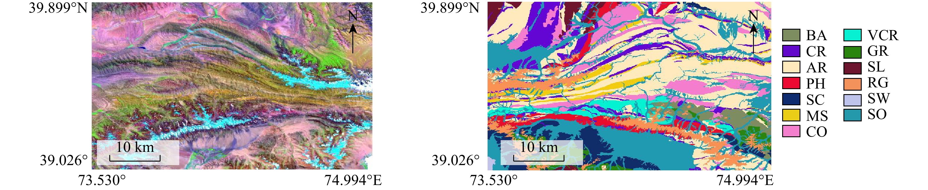
图 3 东昆仑地区Landsat-8遥感影像及地质要素标注示例
Figure 3. Remote sensing images and geological element annotation examples of Landsat-8 in Eastern Kunlun region
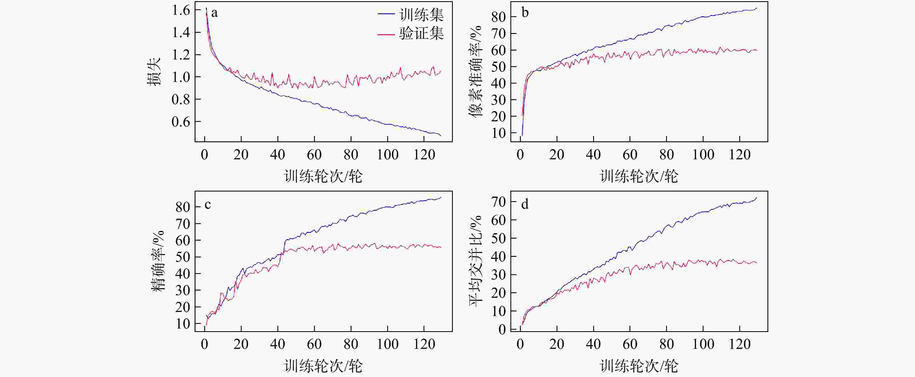
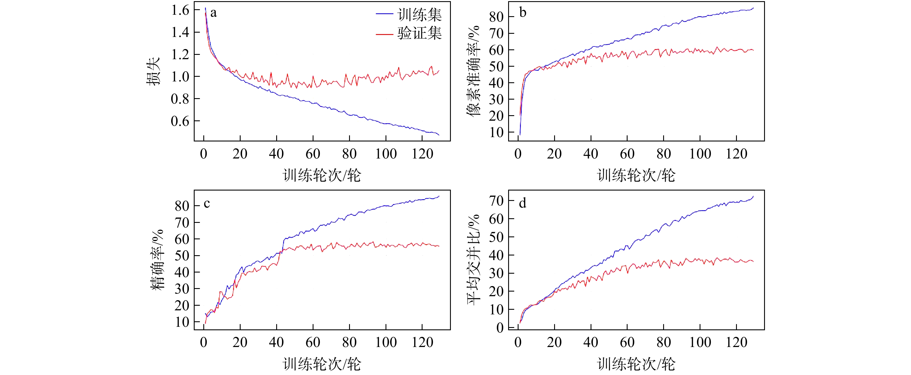
图 4 UltraLightUNet 模型训练过程各项评价指标曲线
Figure 4. Curves of various evaluation indicators of UltraLightUNet model during training
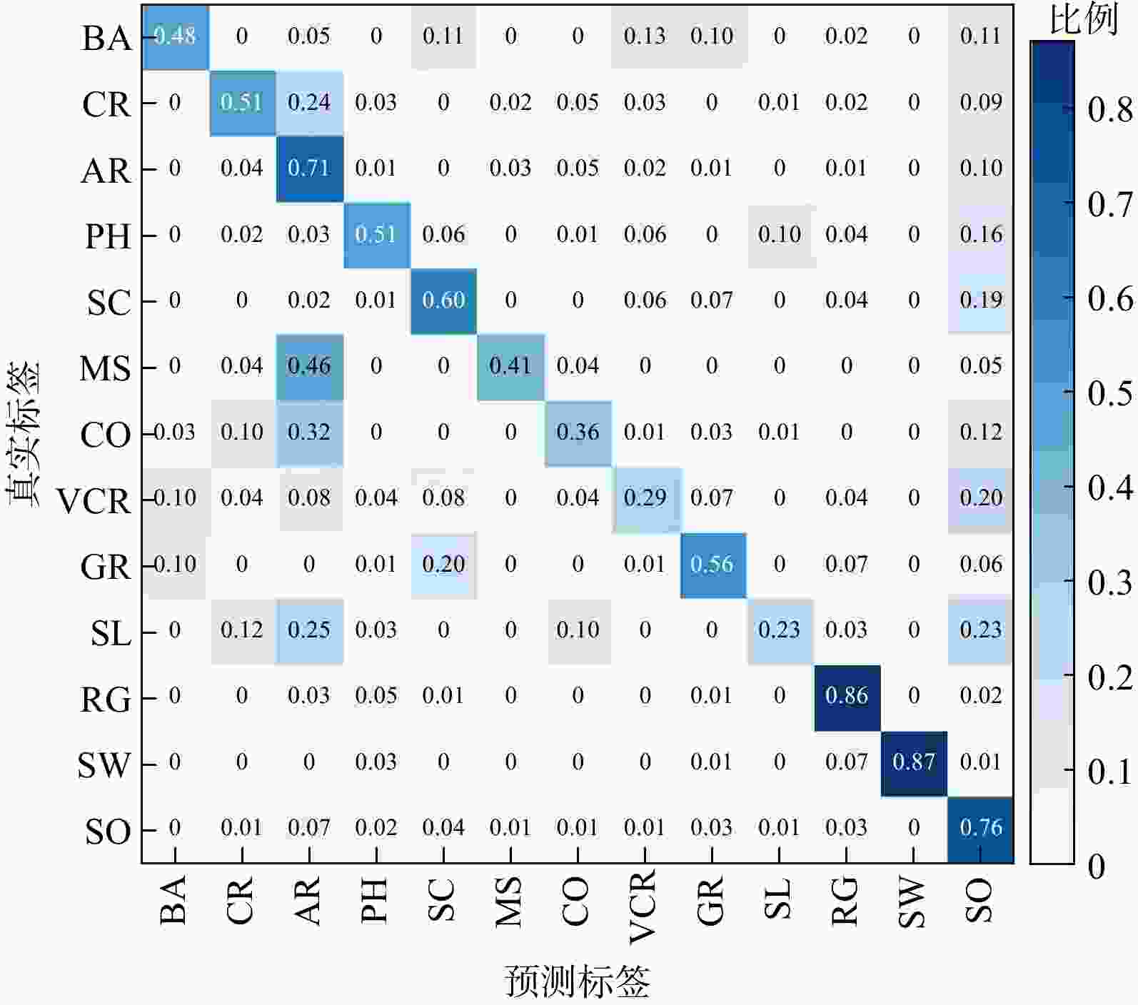
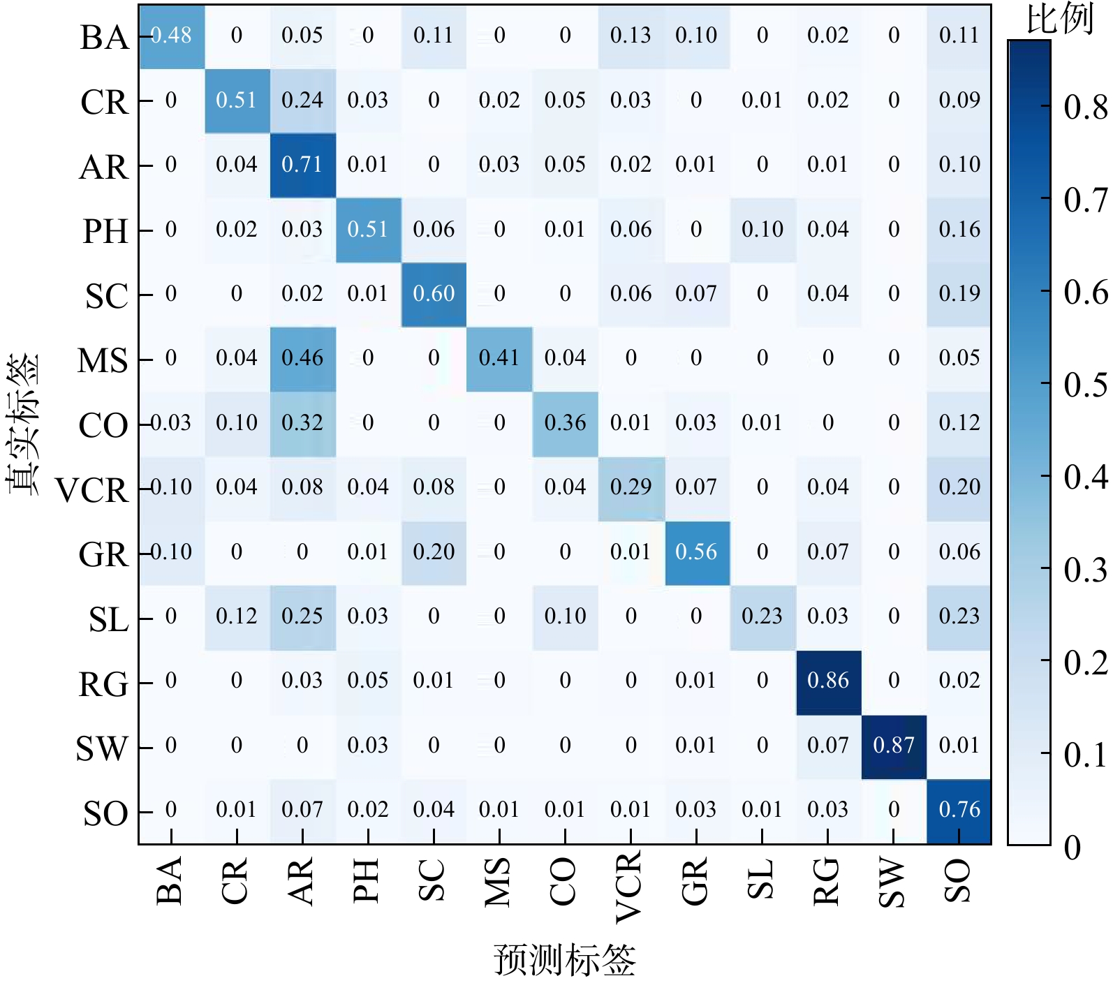
图 5 UltraLightUNet 模型归一化混淆矩阵
Figure 5. Normalized confusion matrix of UltraLightUNet model
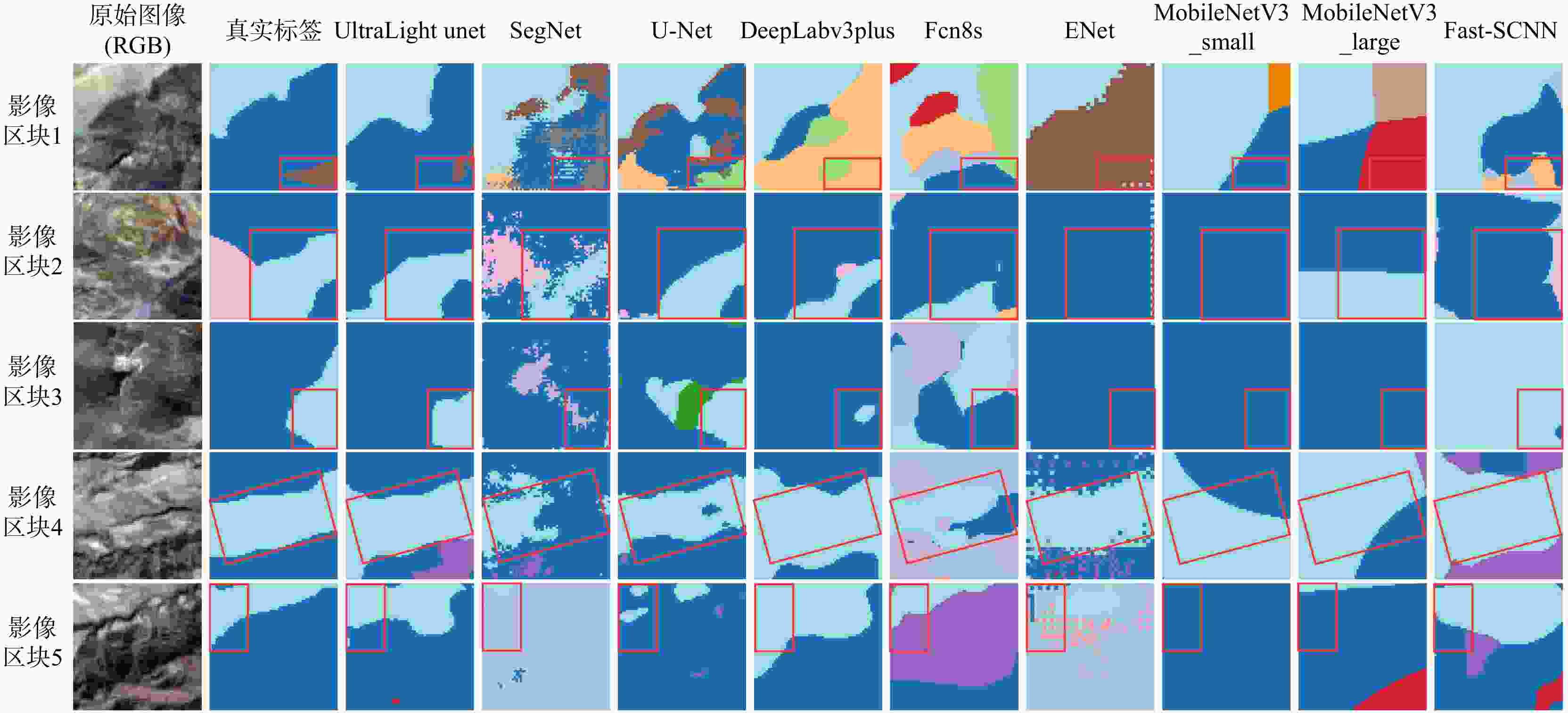
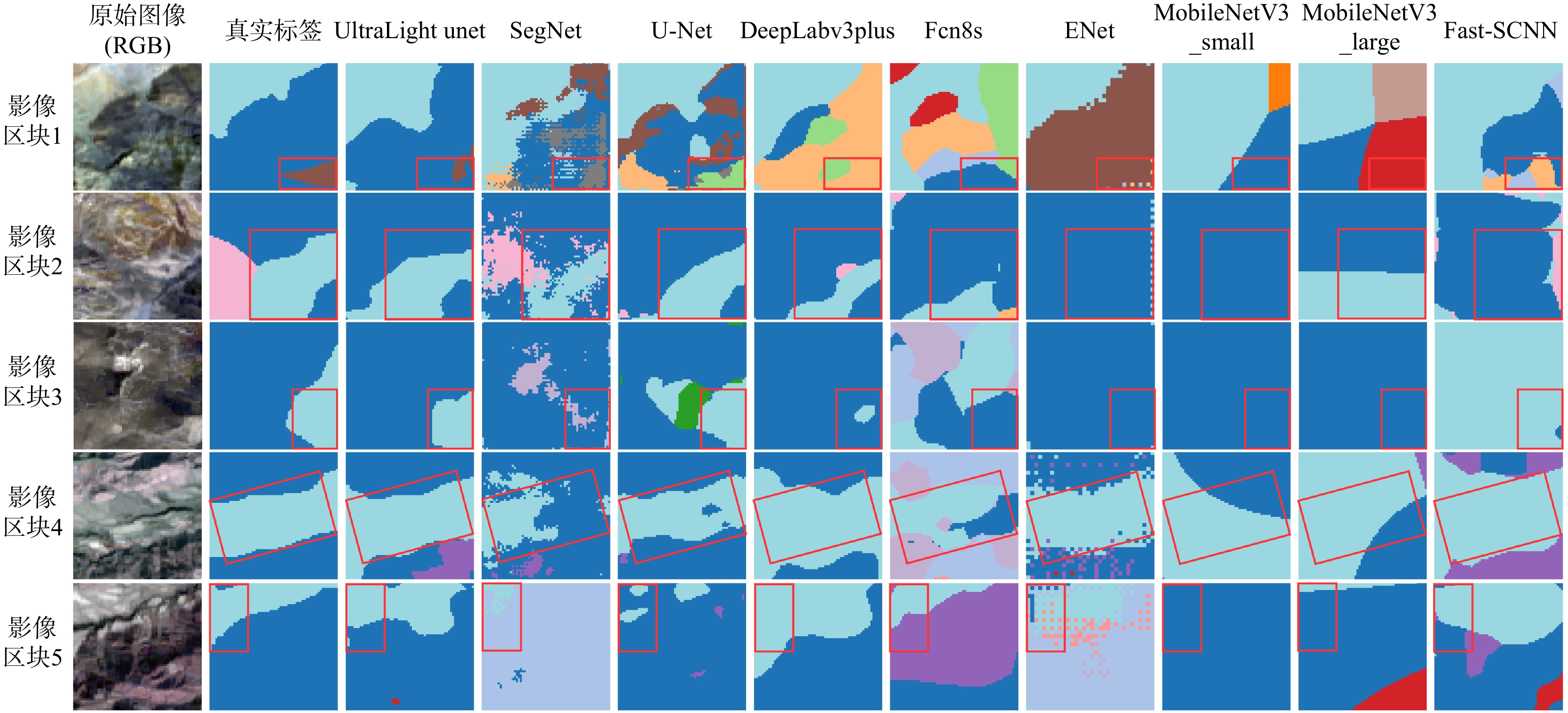
图 6 各模型在 Landsat-8 测试数据集上的地质要素预测示例
红框为人工划定的局部关注区,在各模型预测结果上保持位置对齐,用于横向对比不同模型在同一区域的分割细节差异;图中各色块代表13类地质要素,配色方案与图3 图例保持一致
Figure 6. Prediction examples of geological elements by different models on Landsat-8 test dataset
表 1 东昆仑地区Landsat-8遥感影像数据集划分
Table 1. Partitioning of Landsat-8 remote sensing image dataset for Eastern Kunlun region
划分类型 训练集(train) 验证集(val) 测试集(test) 合计 图像数量/张 2933 834 432 4199  下载: 导出CSV
表 2 东昆仑地区 Landsat-8 数据集各地质类别样本占比
Table 2. Proportions of samples in different geological classes in Landsat-8 dataset for Eastern Kunlun region
地质类别 BA CR AR PH SC MS CO VCR GR SL RG SW SO 占比/% 2.65 8.61 28.11 3.84 5.70 3.67 8.51 2.94 2.82 1.85 7.39 0.19 23.73 注:BA为玄武岩;CR为碳酸盐岩;AR为砂质岩;PH为千枚岩;SC为片岩;MS为泥岩;CO为砾岩;VCR为火山碎屑岩;GR为花岗岩;SL为板岩;RG为岩冰川;SW为地表水;SO为土壤;下同
下载: 导出CSV
表 3 不同模型参数量与浮点运算量的复杂度定量对比
Table 3. Quantitative comparison of model complexity in terms of parameter quantity and floating-point operations
方法 输入尺寸(B×C×H×W) 参数量/M 浮点运算次数/G UltraLightUNet 32×7×64×64 0.32 0.77 SegNet 32×7×64×64 29.48 85.46 U-Net 32×7×64×64 31.04 109.88 DeepLabv3plus 32×7×64×64 63.86 55.29 Fcn8s 32×7×64×64 149.04 176.88 ENet 32×7×64×64 0.41 1.55 MobileNetV3 small 32×7×64×64 2.00 0.78 large 32×7×64×64 6.19 2.70 Fast-SCNN 32×7×64×64 1.16 0.52 注:B为批次大小
下载: 导出CSV
表 4 各模型不同地质类别的像素准确率与平均像素准确率对比
Table 4. Comparison of pixel accuracy and mean pixel accuracy across different geological classes for different models
方法 BA CR AR PH SC MS CO VCR GR SL RG SW SO 平均像素准确率oPA/% 像素准确率PA/% UltraLightUNet 47.98 50.77 71.31 50.70 59.73 41.20 35.92 29.11 55.74 23.36 86.25 87.16 76.07 62.75 segnet 33.44 45.78 70.84 51.71 35.59 23.57 55.54 25.96 44.11 17.97 80.78 57.08 67.71 58.61 U-Net 48.57 36.10 77.91 75.06 56.20 37.44 61.72 42.62 55.15 22.91 87.31 93.44 72.46 66.01 DeepLabv3plus 51.86 49.04 71.69 69.44 53.78 33.14 49.06 27.09 37.68 20.41 84.10 94.22 75.81 63.33 Fcn8s 39.70 38.59 60.95 42.89 30.31 19.61 28.98 15.15 23.73 5.40 83.20 81.38 65.89 50.99 ENet 60.01 47.88 75.01 48.65 45.86 40.64 55.44 15.70 58.08 15.00 88.72 89.40 64.89 61.68 MobileNetV3 small 46.07 42.93 76.16 56.98 42.41 46.16 54.94 25.96 43.74 23.66 78.58 87.21 62.37 60.34 large 64.08 35.85 72.83 56.83 51.04 43.47 35.48 26.62 36.85 18.39 86.24 90.69 68.51 59.74 Fast-SCNN 43.78 39.96 72.17 56.97 27.14 33.16 48.63 24.34 43.54 30.81 80.03 71.55 65.77 57.99
下载: 导出CSV
表 5 各模型不同地质类别的交并比、平均交并比与 F1 分数对比
Table 5. Comparison of intersection over union, mean intersection over union, and F1-score across different geological classes for different models
Method BA CR AR PH SC MS CO VCR GR SL RG SW SO 平均交并比mIoU/% F1分数F1/% 交并比IoU/% UltraLightUNet 34.15 37.14 52.79 35.70 40.87 30.08 27.69 18.47 30.53 16.09 68.38 82.29 56.45 40.82 55.68 segnet 21.98 34.01 50.28 37.18 24.91 19.70 35.79 17.19 24.21 12.91 64.34 49.56 47.85 33.84 48.76 U-Net 39.82 31.09 56.21 44.97 39.42 28.55 40.23 31.39 33.91 18.70 71.04 89.75 59.09 44.94 59.90 DeepLabv3plus 36.10 37.11 53.27 40.59 34.65 28.07 38.33 19.99 25.03 18.48 65.29 84.11 54.54 41.20 56.20 Fcn8s 24.40 21.98 40.00 28.69 20.66 14.60 17.06 10.12 16.64 4.37 63.74 80.41 47.54 30.02 42.51 ENet 33.88 37.09 51.52 38.96 37.28 27.50 34.18 11.23 30.10 11.07 66.32 83.59 54.01 39.75 54.20 MobileNetV3 small 30.37 33.15 53.20 37.36 33.05 31.95 38.35 19.37 26.54 12.91 56.06 79.18 47.77 38.40 53.53 large 42.55 27.30 47.68 39.77 36.46 31.81 26.99 18.17 27.42 15.40 63.04 76.26 51.12 38.77 53.87 Fast-SCNN 27.84 29.65 48.71 37.79 19.91 24.28 36.27 16.09 25.10 20.38 60.79 66.22 47.87 35.45 50.53
下载: 导出CSV
-
[1] PANDE A R, NERKAR P S, BORSE B, et al. Unmanned aerial vehicles an overview and applications[J]. Graduate Research in Engineering and Technology, 2022: 20-23. [2] AL MUNEEM I, FAHIM S M, KHAN F R, et al. Research and development of multipurpose unmanned aerial vehicle (flying drone)[C]//Anon. 2021 IEEE 12th Annual Ubiquitous Computing, Electronics & Mobile Communication Conference (UEMCON). New York, USA: IEEE, 2022: 402-406. [3] BEG A, QURESHI A R, SHELTAMI T, et al. UAV-enabled intelligent traffic policing and emergency response handling system for the smart city[J]. Personal and Ubiquitous Computing, 2021, 25(1): 33-50. doi: 10.1007/s00779-019-01297-y [4] AKRAM M A, AHMAD H, MIAN A N, et al. Blockchain-based privacy-preserving authentication protocol for UAV networks[J]. Computer Networks, 2023, 224: 109638. doi: 10.1016/j.comnet.2023.109638 [5] BES J, DENDARIETA J, RIAZUELO L, et al. DWA-3D: A reactive planner for robust and efficient autonomous UAV navigation in confined environments[J]. Robotics and Autonomous Systems, 2026, 195: 105196. doi: 10.1016/j.robot.2025.105196 [6] YANG J K, ZHAI Z Q, LI Y L, et al. Design and research of residual film pollution monitoring system based on UAV[J]. Computers and Electronics in Agriculture, 2024, 217: 108608. doi: 10.1016/j.compag.2023.108608 [7] NAZIR A, MIR R N, QURESHI S. Quantized hashing: Enabling resource-efficient deep learning models at the edge[J]. International Journal of Information Technology, 2024, 16(4): 2353-2361. doi: 10.1007/s41870-024-01767-4 [8] FIDELIS S, CASTRO M, SIQUEIRA F. Improving edge AI for industrial IoT applications with distributed learning using consensus[J]. Design Automation for Embedded Systems, 2024, 28(1): 67-89. doi: 10.1007/s10617-024-09284-0 [9] WANG G, LI Y X, CHEN W T, et al. S3-mamba: Small-size-sensitive mamba for lesion segmentation[C]//Anon. Proceedings of the 39th AAAI Conference on Artificial Intelligence. Palo Alto: AAAI Press, 2025: 7655-7664. [10] SHU H, LI W S, TANG Y H, et al. TinySAM: Pushing the envelope for efficient segment anything model[EB/OL]. (2023-12-21)[2026-10-16]. https://arxiv.org/abs/2312.13789v1. [11] ZHENG Y, HE Q N. Research and comparison of lightweight U-Net based on GhostNets for medical and remote sensing images[C]//Anon. 2023 8th International Conference on Intelligent Computing and Signal Processing (ICSP). X'an, China: IEEE, 2023: 2082-2086. [12] ZHANG L L, ZHANG N, SHI R, et al. SG-Det: Shuffle-GhostNet-based detector for real-time maritime object detection in UAV images[J]. Remote Sensing, 2023, 15(13): 3365. doi: 10.3390/rs15133365 [13] WANG G Y, CHEN J H, MO L F, et al. Lightweight land cover classification via semantic segmentation of remote sensing imagery and analysis of influencing factors[J]. Frontiers in Environmental Science, 2024, 12: 1329517. doi: 10.3389/fenvs.2024.1329517 [14] 陈琳, 朱庆, 胡翰, 等. FLASH: 无人机滑坡灾情轻巧感知系统[J]. 航空学报, 2025, 46(11): 262-279. doi: 10.7527/S1000-6893.2025.31293CHEN L, ZHU Q, HU H, et al. FLASH: Flexible and lightweight awareness of slope hazard[J]. Acta Aeronautica et Astronautica Sinica, 2025, 46(11): 262-279. (in Chinese with English abstract) doi: 10.7527/S1000-6893.2025.31293 [15] MA H Z, YANG X H, FAN R Y, et al. Refined water-body types mapping using a water-scene enhancement deep models by fusing optical and SAR images[J]. IEEE Journal of Selected Topics in Applied Earth Observations and Remote Sensing, 2024, 17: 17430-17441. doi: 10.1109/JSTARS.2024.3459916 [16] SUN J J, FRATTINI P, WANG X L, et al. Deposit comminution in a weak variably-cemented breccia rock avalanche[J]. Engineering Geology, 2023, 326: 107331. doi: 10.1016/j.enggeo.2023.107331 [17] 王志民, 秦越强, 柴晨晖, 等. 基于FLAC3D与无人机航测的全部垮落法采煤塌陷分析[J]. 地质科技通报, 2024, 43(1): 204-215. doi: 10.19509/j.cnki.dzkq.tb20220250WANG Z M, QIN Y Q, CHAI C H, et al. Coal mining collapse analysis of total caving method based on FLAC3D and UAV aerial surveying[J]. Bulletin of Geological Science and Technology, 2024, 43(1): 204-215. (in Chinese with English abstract) doi: 10.19509/j.cnki.dzkq.tb20220250 [18] 丁要轩, 龚文平, 程展, 等. 基于多期无人机影像的滑坡地表竖向变形测量模型试验与工程应用[J]. 地质科技通报, 2023, 42(2): 267-278. doi: 10.19509/j.cnki.dzkq.2022.0137DING Y X, GONG W P, CHENG Z, et al. Model tests of the vertical ground deformation measurement of landslide based on multiple UAV images and its application[J]. Bulletin of Geological Science and Technology, 2023, 42(2): 267-278. (in Chinese with English abstract) doi: 10.19509/j.cnki.dzkq.2022.0137 [19] WANG F, CHEN F, DENG H, et al. An improved monitoring strategy for shallow rainfall-induced landslides under critical site-specific recognition[J]. Landslides, 2024, 21(10): 2569-2581. doi: 10.1007/s10346-024-02298-6 [20] POUTH NKOMA A M, MELI'I J L, GWETH M M A, et al. An approach to assess hazards in the vicinity of mountain and volcanic areas[J]. Landslides, 2025, 22(3): 693-708. doi: 10.1007/s10346-024-02278-w [21] 庞鑫, 袁明, 卢渊, 等. 基于无人机LiDAR仿地飞行技术的高陡边坡危岩体快速识别方法[J]. 地质科技通报, 2023, 42(6): 21-30. doi: 10.19509/j.cnki.dzkq.tb20220427PANG X, YUAN M, LU Y, et al. Rapid identification method for the dangerous rock mass of a high-steep slope based on UAV LiDAR and ground imitation flight[J]. Bulletin of Geological Science and Technology, 2023, 42(6): 21-30. (in Chinese with English abstract) doi: 10.19509/j.cnki.dzkq.tb20220427 [22] HE K, DONG J, MA H Z, et al. Remote sensing image interpretation of geological lithology via a sensitive feature self-aggregation deep fusion network[J]. International Journal of Applied Earth Observation and Geoinformation, 2025, 137: 104384. doi: 10.1016/j.jag.2025.104384 [23] HE K, JIA M T, CHEN M F. Entropy evaluation method for sandstone uranium reservoir characteristics based on convex hull search[J]. IEEE Access, 2020, 8: 46307-46323. doi: 10.1109/ACCESS.2020.2978153 [24] HE K, ZHANG Z J, DONG Y S, et al. Improving geological remote sensing interpretation via a contextually enhanced multiscale feature fusion network[J]. IEEE Journal of Selected Topics in Applied Earth Observations and Remote Sensing, 2024, 17: 6158-6173. doi: 10.1109/JSTARS.2024.3374818 [25] SAKIB T H, HOSAIN M T, MOROL M K. Small language models: Architectures, techniques, evaluation, problems and future adaptation[EB/OL]. (2025-05-29)[2026-10-16]. https://arxiv.org/abs/2505.19529v2. [26] BATISTA D B, SAVASTANO V L M, PINTO M F, et al. Semantic segmentation for automatic extraction of linear geological structures from UAV imagery[J]. SN Computer Science, 2025, 6(6): 738. doi: 10.1007/s42979-025-04265-x [27] RAHMAN M M, MARCULESCU R. UltraLightUNet: Rethinking U-shaped network with multi-kernel lightweight convolutions for medical image segmentation[EB/OL]. (2024-09-27)[2026-10-20]. https: //openreview.net/forum?id=BefqqrgdZ1. [28] RONNEBERGER O, FISCHER P, BROX T. U-Net: Convolutional networks for biomedical image segmentation[C]//NAVAB N, HORNEGGER J, WELLS W M, et al. Medical Image Computing and Computer-Assisted Intervention-MICCAI 2015. Cham: Springer, 2015: 234-241. [29] CHEN L C, ZHU Y, PAPANDREOU G, et al. Encoder-decoder with atrous separable convolution for semantic image segmentation[C]//Anon. Proceedings of the European Conference on Computer Vision (ECCV). Munich: Springer, 2018: 801-818. [30] BORGEAUD S, BUCHATSKAYA E, CAI T, et al. Training compute-optimal large language models[C]//Anon. Advances in Neural Information Processing Systems 35. Red Hook: Curran Associates, 2022: 30016-30030. [31] LIU R, GAO J, ZHAO J, et al. Can 1B LLM surpass 405B LLM? Rethinking compute-optimal test-time scaling[EB/OL]. (2025-02-10)[2026-10-20]. https: //arxiv.org/abs/2502.06703. [32] FU X Y, LASKAR M T R, KHASANOVA E, et al. Tiny titans: Can smaller large language models punch above their weight in the real world for meeting summarization?[EB/OL]. (2024-02-01)[2026-10-20]. https: //arxiv.org/abs/2402.00841v2. [33] LU Y, HE K, XU H R, et al. Remote-sensing interpretation for soil elements using adaptive feature fusion network[J]. IEEE Transactions on Geoscience and Remote Sensing, 2023, 61: 4505515. [34] HE K, FENG R Y, ZHANG Z J, et al. Remote sensing interpretation of geological elements via a synergistic neural framework with multi-source data and prior knowledge[J]. Remote Sensing, 2025, 17(16): 2772. doi: 10.3390/rs17162772 [35] MA H Z, YANG X H, FAN R Y, et al. Prolonged water body types dataset of urban agglomeration in central China from 1990 to 2021[J]. Scientific Data, 2025, 12: 480. doi: 10.1038/s41597-025-04794-3 [36] HE K, DONG Y S, HAN W, et al. An assessment on the off-road trafficability using a quantitative rule method with geographical and geological data[J]. Computers & Geosciences, 2023, 177: 105355. doi: 10.1016/j.cageo.2023.105355 [37] CHENG J, DENG C J, SU Y Z, et al. Methods and datasets on semantic segmentation for unmanned aerial vehicle remote sensing images: A review[J]. ISPRS Journal of Photogrammetry and Remote Sensing, 2024, 211: 1-34. doi: 10.1016/j.isprsjprs.2024.03.012 [38] LIU Y Q, CHEN J P, SUN X H, et al. A progressive framework combining unsupervised and optimized supervised learning for debris flow susceptibility assessment[J]. Catena, 2024, 234: 107560. doi: 10.1016/j.catena.2023.107560 [39] PETRAKIS G, PARTSINEVELOS P. Lunar ground segmentation using a modified U-Net neural network[J]. Machine Vision and Applications, 2024, 35(3): 50. doi: 10.1007/s00138-024-01533-3 [40] SUN H, ZHANG Z Y, HUANG L L, et al. Category-aware Siamese learning network for few-shot segmentation[J]. Cognitive Computation, 2024, 16(3): 924-935. doi: 10.1007/s12559-024-10273-5 [41] SUN J W, YUAN G Q, SONG L Y, et al. Unmanned aerial vehicles (UAVs) in landslide investigation and monitoring: A review[J]. Drones, 2024, 8(1): 30. doi: 10.3390/drones8010030 [42] AUFLIČ M J, HERRERA G, MATEOS R M, et al. Landslide monitoring techniques in the geological surveys of Europe[J]. Landslides, 2023, 20(5): 951-965. doi: 10.1007/s10346-022-02007-1 [43] TAO L F, XU Y J, HE K, et al. Pan-spatial earth information system: A new methodology for cognizing the earth system[J]. The Innovation, 2025, 6(3): 100770. doi: 10.1016/j.xinn.2024.100770 -

 下载:


 点击查看大图
计量
- 文章访问数: 253
- PDF下载量: 27
- 被引次数: 0