投审稿入口


3D geological modeling technology for super-large concealed Daotuo manganese deposit in Guizhou based on synergistic constraints from multi-source heterogeneous data
-
摘要:目的
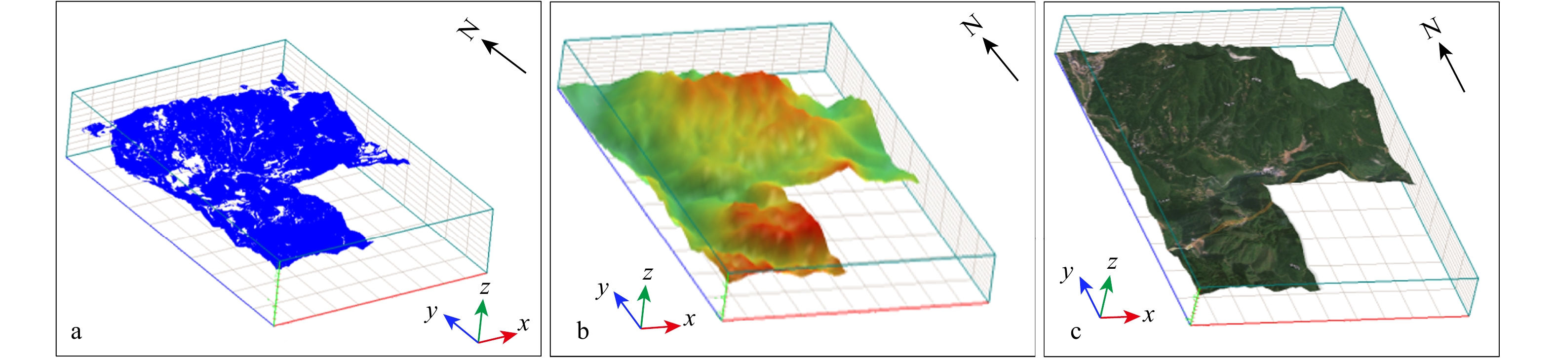
深部隐伏锰矿三维地质建模普遍存在多源勘查数据融合程度低、多类信息协同约束机制缺失、超薄层状矿体精细刻画难度大等问题。贵州道坨为超大型全隐伏喷溢沉积型锰矿床,矿体埋深大、厚度薄、成矿地质结构复杂,传统二维图件难以反映矿体真实三维赋存状态。以该矿床为研究对象,融合数字高程模型(DEM)、地质填图、钻探编录、勘查线剖面、遥感影像、音频大地电磁测深(AMT)多源异构勘查数据,构建地表−地层−构造−矿体一体化三维地质模型,为深部隐伏锰矿数字化勘查与资源定量评价提供技术支撑。
方法建立多源异构数据标准化处理、三重一致性校验、多源信息协同约束、超薄矿体增量模拟的完整技术流程;划分 18 个地质建模单元,采用曲面拟合、拓扑推理、克里金插值完成地质体实体构建;结合 67 个钻孔、722 件有效品位样品开展品位归一化预处理,实施模型剖面解析、虚拟钻孔分析、模型拆解,基于地质统计学块体克里金法开展资源−储量估算。
结果该模型完整复现研究区−
2000 m 至地表的三维地质空间结构,清晰揭示南华系大塘坡组含锰岩系、F3 浅表正断层与缓倾斜层状锰矿体的空间展布规律;经多源数据一致性校验,数据源综合合格率达 97.2%;地质统计学估算结果与传统块段法资源量误差仅 0.9%,锰平均品位误差 0.31%,可有效校验原始勘查数据可靠性,厘清构造与矿体的空间耦合关系。结论多源异构数据协同约束建模技术能够有效解决超薄隐伏矿体建模失真难题,显著提高深部找矿工程部署与矿产资源评价精度;形成的成套技术范式,可为黔东乃至扬子地区大塘坡式隐伏锰矿深部找矿突破与矿山数字化建设提供参考。
Abstract:ObjectiveDeep concealed mineral exploration is a critical direction for implementing China’s new-round prospecting breakthrough strategy and securing domestic mineral resource supply. Nevertheless, three-dimensional (3D) geological modeling for deep concealed manganese deposits still faces prominent bottlenecks: low integration of multi-source exploration datasets, insufficient synergistic constraint mechanisms among multi-type geological information, and technical obstacles for fine characterization of ultra-thin stratiform ore bodies. The Daotuo deposit in Guizhou represents a typical super-large fully concealed exhalative-sedimentary manganese deposit of the Datangpo-type within the Yangtze Block. It is characterized by great burial depth, ultra-thin ore bodies, and complicated geological architectures, which cannot be adequately depicted by conventional two-dimensional geological maps. This study aims to construct an integrated 3D geological model of surface–strata–structure–ore body constrained by multi-source heterogeneous data, so as to provide technical support for digital exploration and quantitative resource assessment of deep concealed manganese ore bodies.
MethodsMulti-source heterogeneous datasets including a digital elevation model (DEM), geological mapping results, drilling logs, exploration profile data, remote sensing imagery, and audio magnetotelluric (AMT) sounding data were comprehensively integrated. A complete technical workflow was established, covering standardized multi-source data preprocessing, three-fold consistency verification, multi-information synergistic constraint, and incremental simulation for ultra-thin ore bodies. A total of 18 geological modeling units were delineated. Surface fitting, topological reasoning, and Kriging interpolation were adopted to construct solid geological bodies. Based on 67 boreholes and 971 grade samples, 722 valid samples were retained after outlier elimination and grade normalization via log-Z-score transformation. The normalized samples passed the Shapiro-Wilk normality test. Model cross-section interpretation, virtual borehole analysis, and model decomposition were implemented, and the block Kriging geostatistical method was applied for resource–reserve calculation.
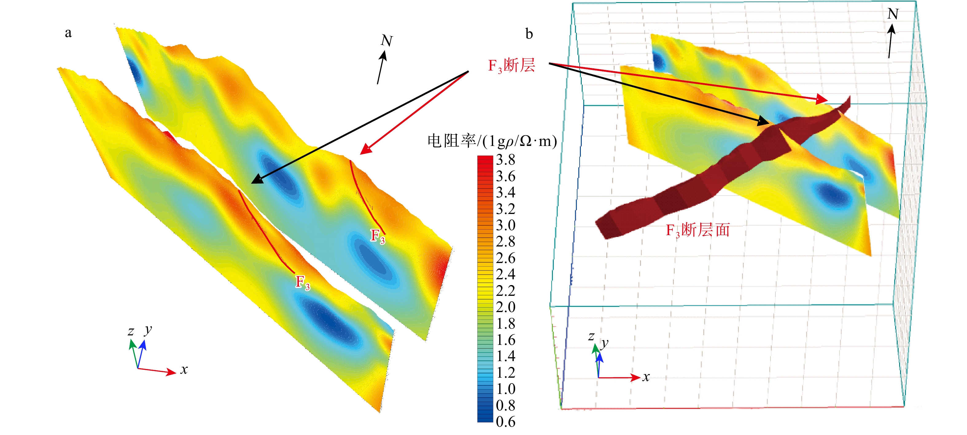
ResultsThe established model fully reconstructed the 3D geological structure of the study area from the ground surface down to −2 000 m elevation, and clearly revealed the spatial distribution of the manganese-bearing rock series of Nanhua Series Datangpo Formation, the shallow F3 normal fault, and the gently dipping stratiform manganese ore bodies. After three-fold multi-source consistency verification, the comprehensive qualification rate of the data sources reached 97.2 %. Geostatistical resource estimation showed only 0.9 % relative discrepancy compared with the traditional block-segment method, and the error of average manganese grade was merely 0.31 %. Modeling results confirmed that the F3 fault only affected shallow strata and did not damage deep manganese ore bodies. The integrated model could effectively validate the reliability of original exploration data and clarify the spatial coupling relationships between geological structures and ore bodies.
ConclusionThe modeling technique based on synergistic constraints from multi-source heterogeneous data can effectively solve the problem of distortion frequently encountered in modeling ultra-thin concealed ore bodies, and significantly improve the precision of deep-prospecting engineering deployment and mineral resource evaluation. The formed complete technical paradigm can provide references for deep prospecting breakthroughs of Datangpo-type concealed manganese deposits and mine digital construction in eastern Guizhou and even the broader Yangtze Block.
-
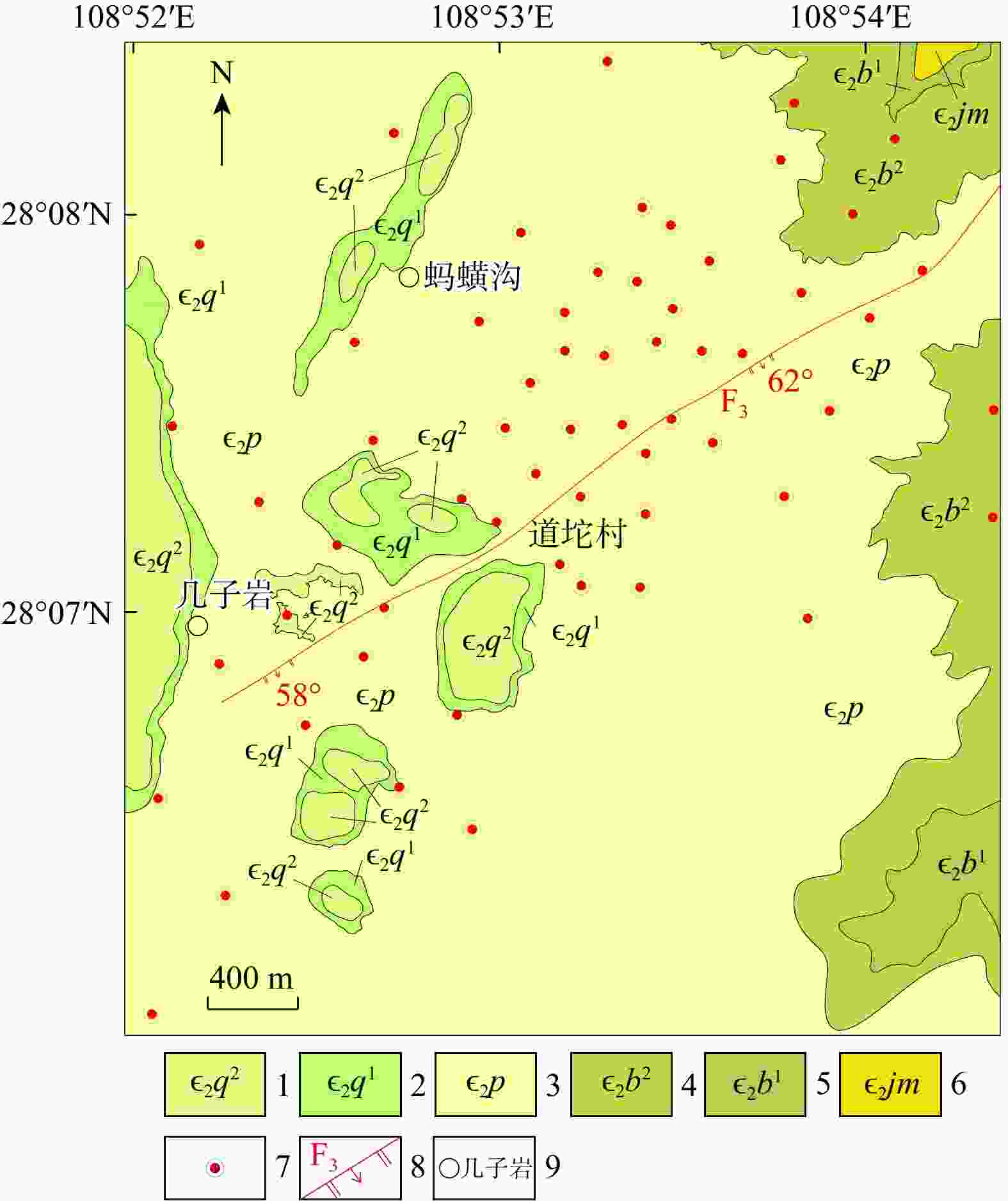
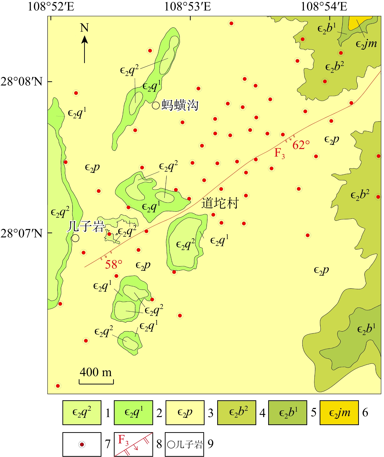
图 1 道坨锰矿床地质简图
1. 清虚洞组第二段;2. 清虚洞组第一段;3. 杷榔组;4. 变马冲组第二段;5. 变马冲组第一段;6. 九门冲组;7. 钻孔位置;8. 正断层
Figure 1. Geological map of Daotuo manganese deposit

图 2 道坨锰矿三维建模流程图
Figure 2. Flowchart of 3D geological modeling of Daotuo manganese deposit
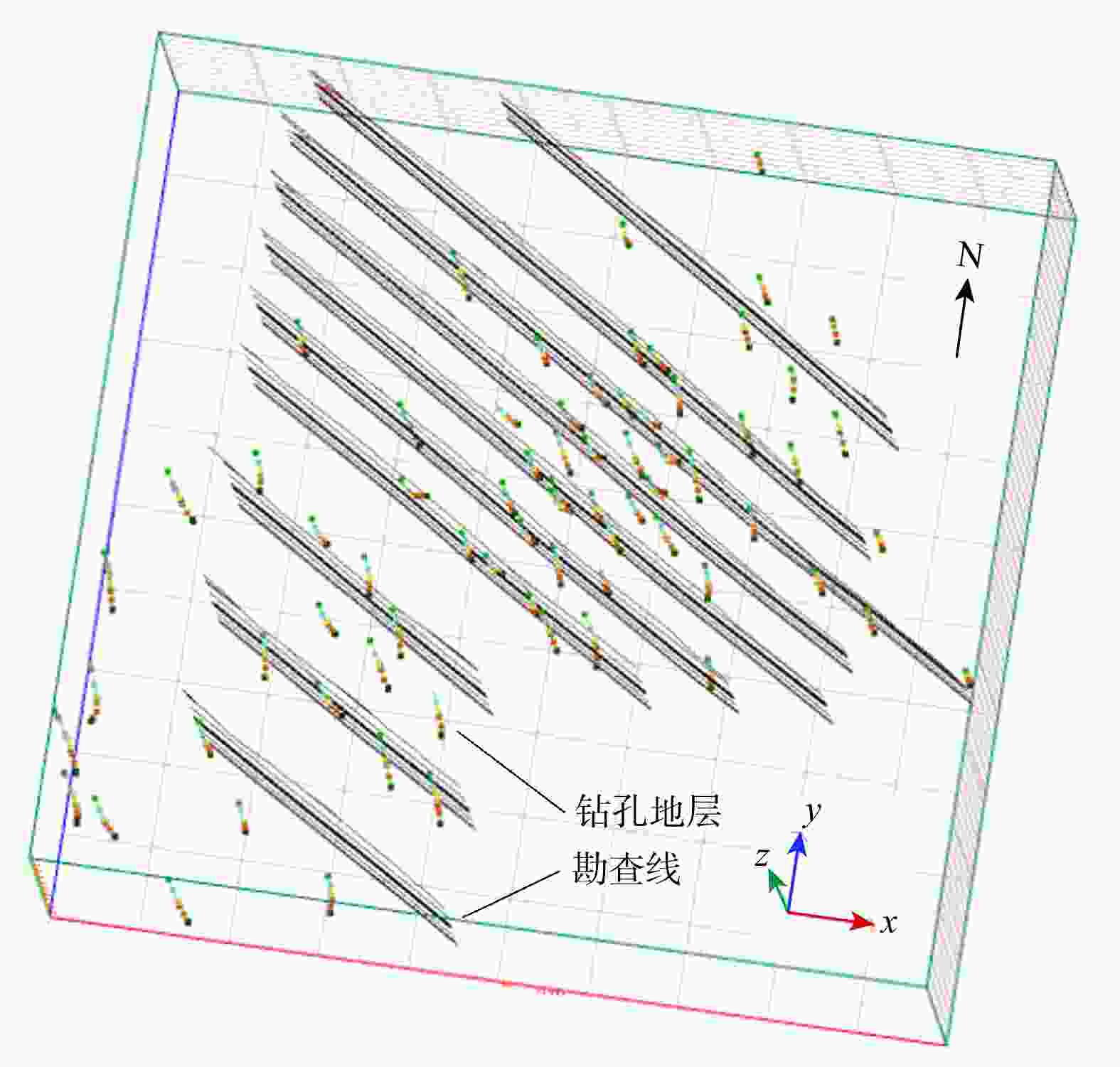
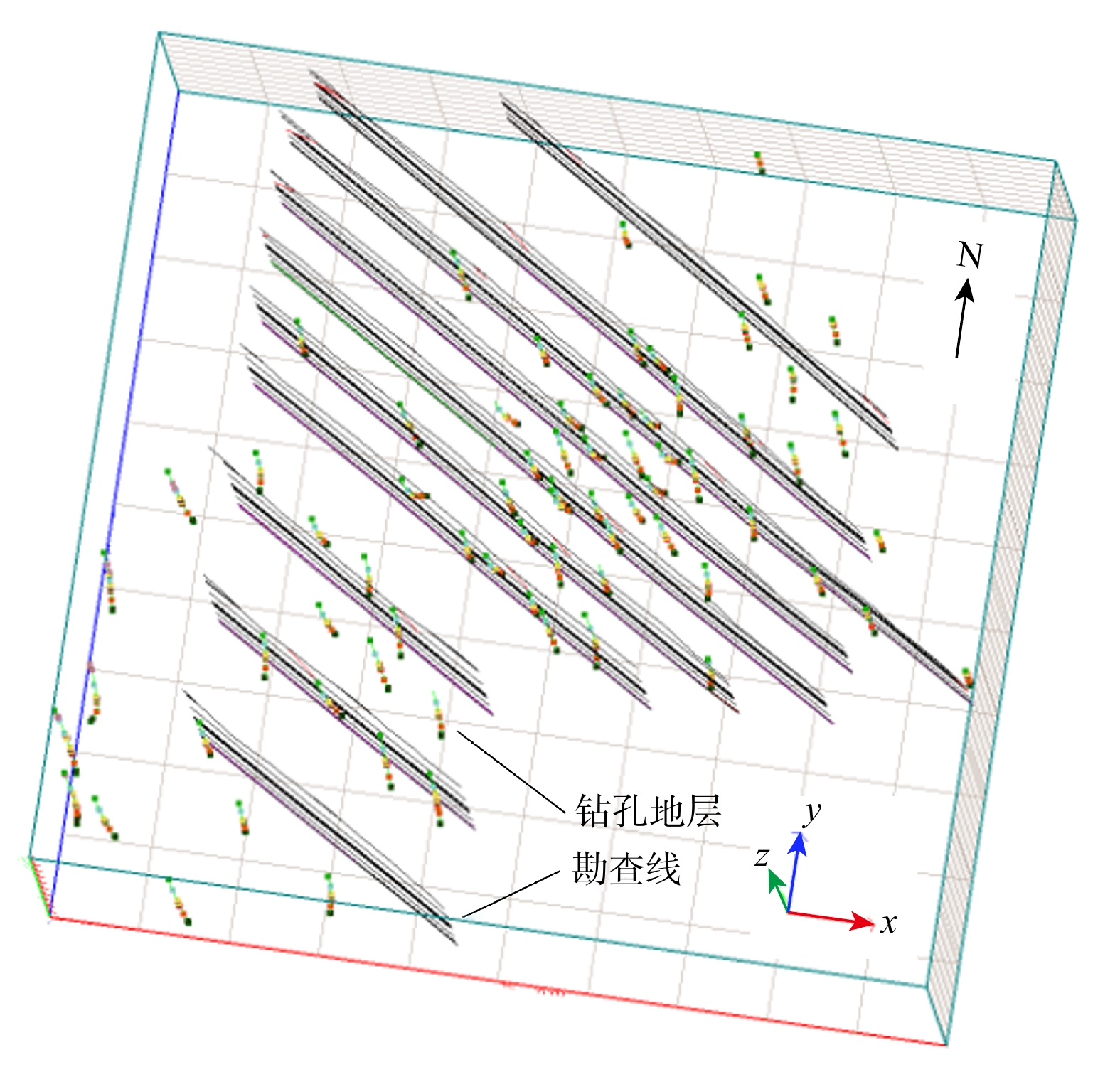
图 3 道坨锰矿钻孔−勘查剖面三维数据可视化
Figure 3. 3D visualization of borehole–exploration profile data for Daotuo manganese deposit
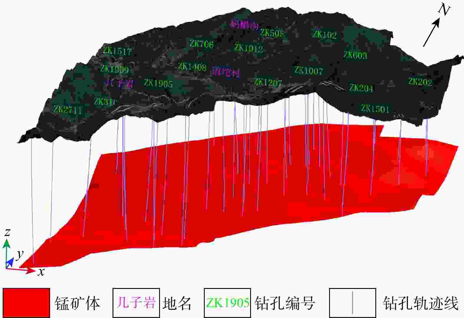
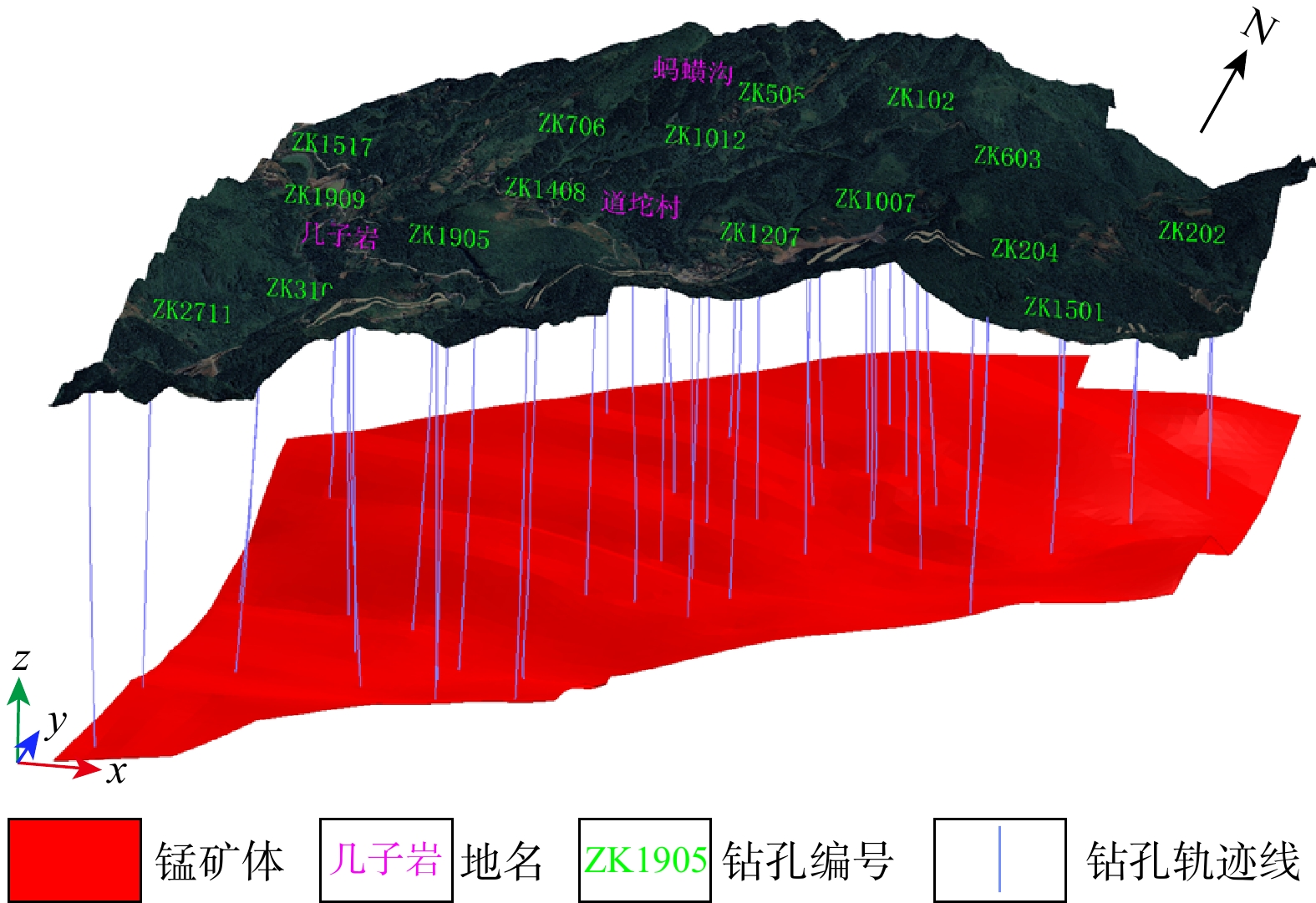
图 7 道坨锰矿床锰矿体三维模型
Figure 7. 3D model of manganese ore bodies of Daotuo manganese deposit
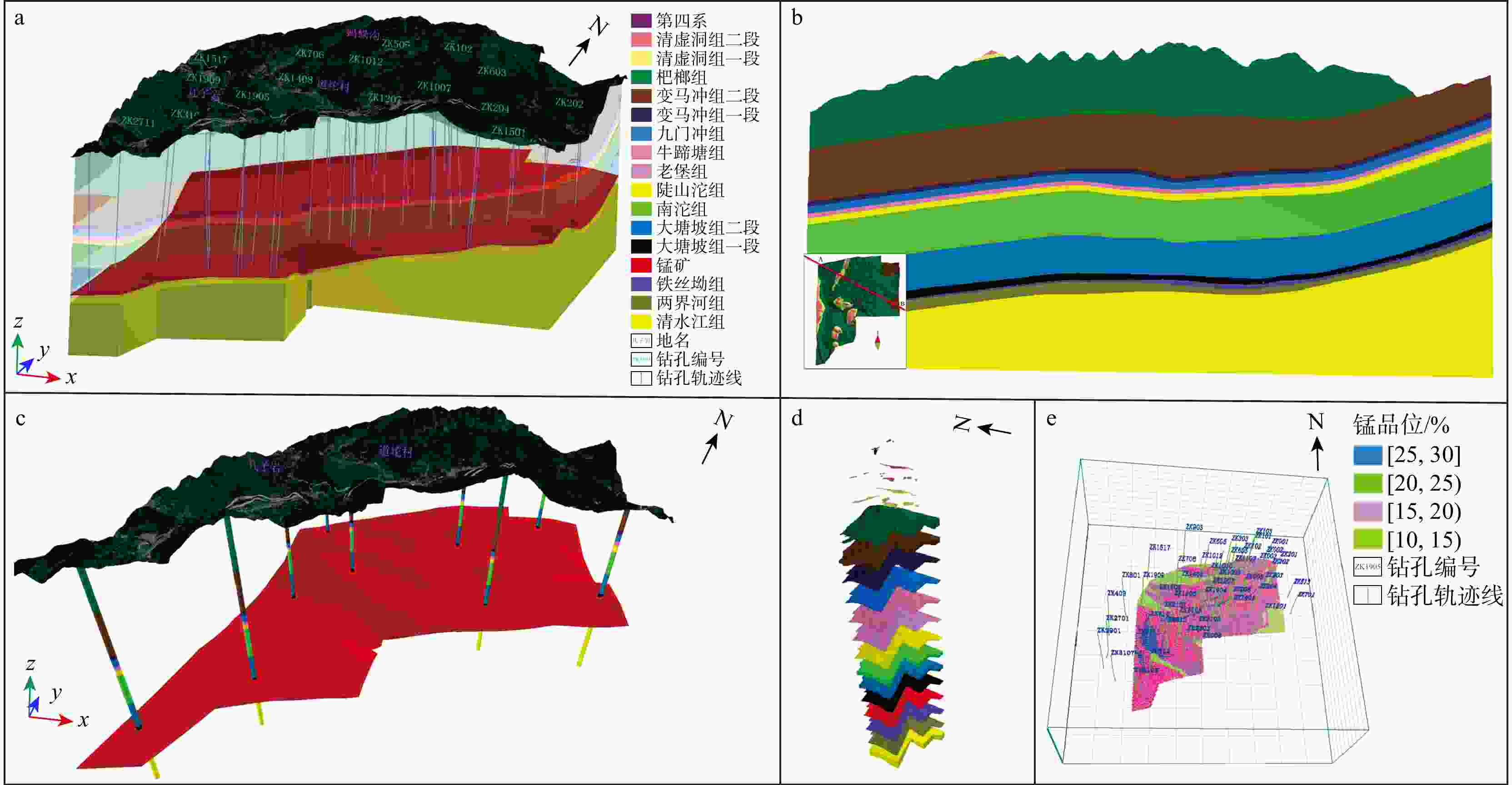
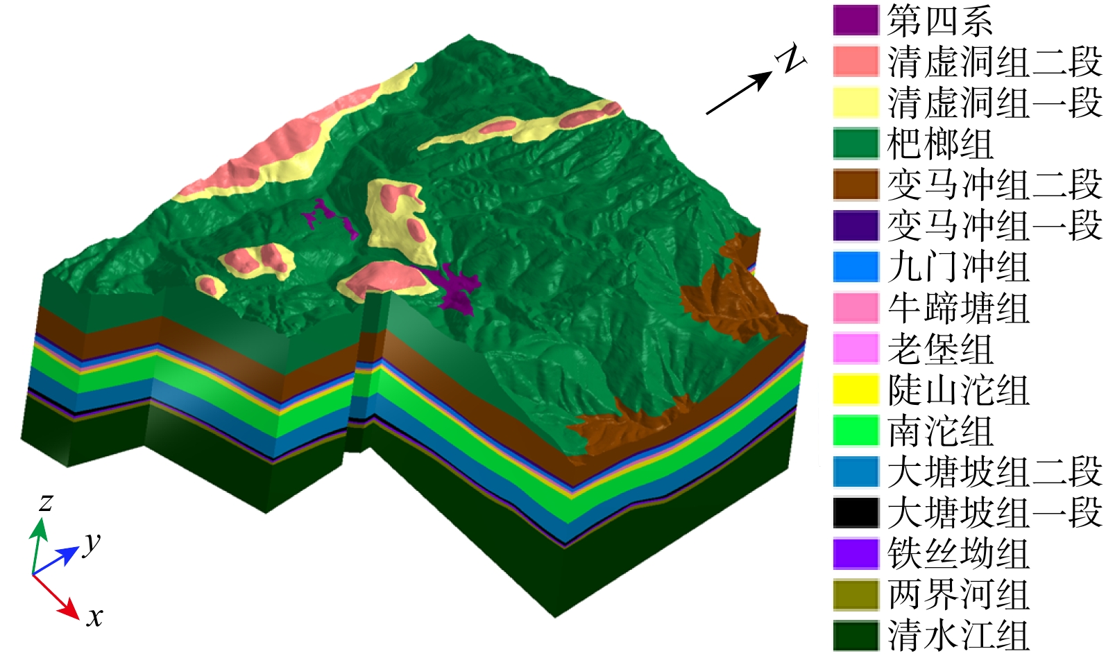
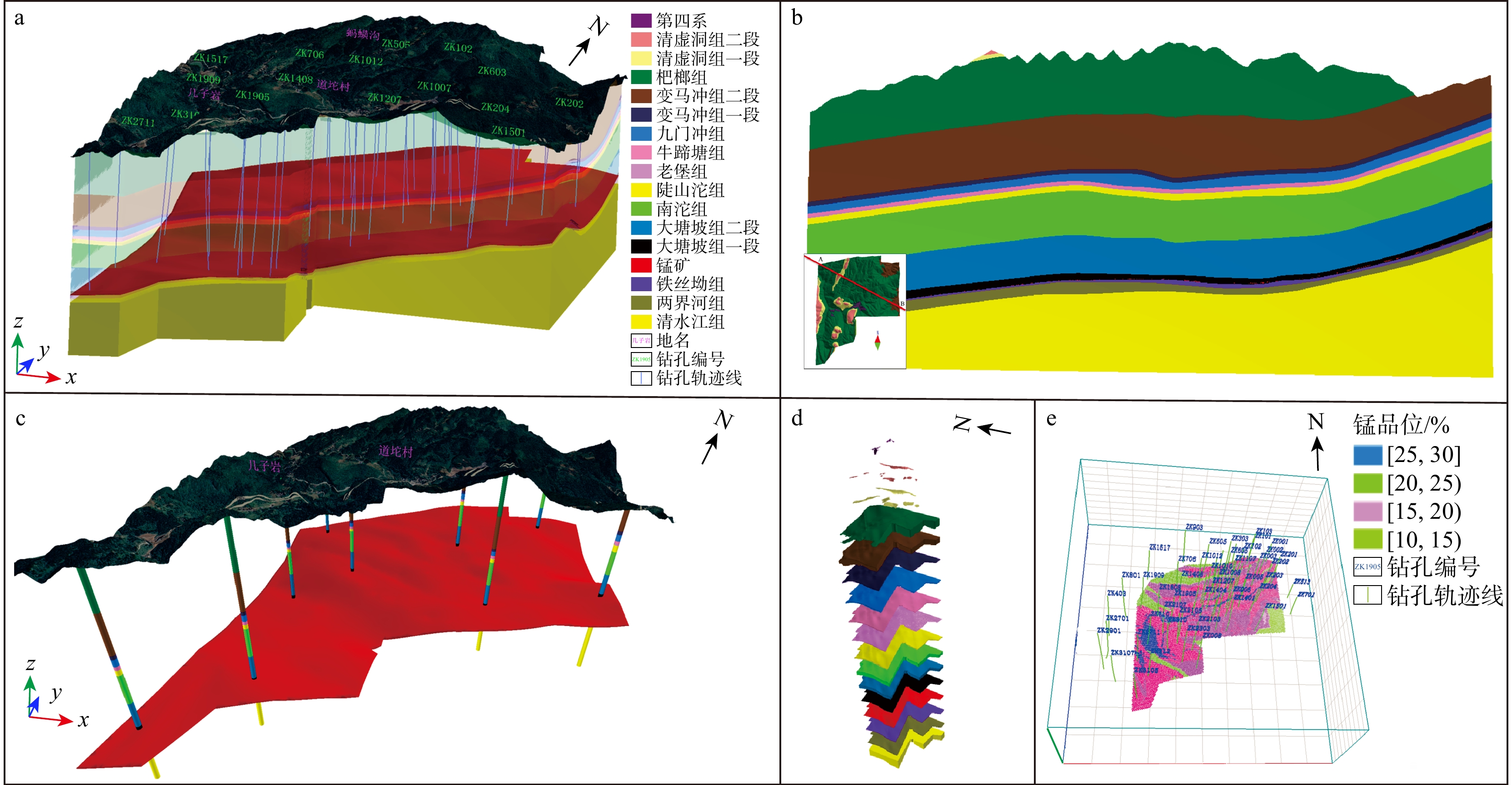
图 8 道坨锰矿床地表−地层−构造−矿体一体化三维地质模型
Figure 8. Integrated 3D geological model of surface-strata-structure-ore body for Daotuo manganese deposit
表 1 锰品位预处理前后统计特征
Table 1. Statistical characteristics of manganese grade before and after preprocessing
数据分组 有效样品
数/件均值/% 标准
差/%偏度 峰度 Shapiro-
Wilk P值原始全部样品 971 16.741 7.391 0.153 1.770 0.000 数据剔除后原始样品 722 20.175 5.149 −0.210 2.203 0.000 对数-Zscore归一化样品 722 0 1 0.138 2.701 0.062 注:Shapiro-Wilk检验显著性水平α=0.05,P>0.05认为数据服从正态分布。  下载: 导出CSV
表 2 多源数据一致性校验量化结果
Table 2. Quantitative results of multi-source data consistency validation
校验类型 校验样本 偏差评价指标 平均偏差 地表地质界线与
DEM匹配校验12 km2填图区
与22条界线平面坐标
偏差≤2 m1.12 钻探分层与AMT反演
界面深度对比校验2条AMT剖面与
67个钻孔矿层界面高程与地层
深度偏差≤5 m2.87 相邻勘查线剖面间地层
与矿体空间交叉验证10条勘探剖面与18组
地层−矿体对比单元地层厚度
相对偏差≤3%1.64 注:AMT为音频大地电磁测深;DEM为数字高程模型;下同。
下载: 导出CSV
表 3 道坨锰矿床建模单元
Table 3. Modeling units of Daotuo manganese deposit
名称 代号 厚度范围/m 主要特性 地层建模单元 第四系 Q 0~36.75 地表腐植土、黏土、粉质黏土、砂、砾等 清虚洞组二段 ∈2q2 108.56~180.56 浅灰色、灰色块状泥粉晶灰岩等 清虚洞组一段 ∈2q1 16.54~53.95 灰色、深灰色薄层条带状泥粉晶灰岩夹深色中层泥粉晶灰岩等 杷榔组 ∈2p 206.91~470.88 深灰色薄层粉砂质页岩偶夹灰白色薄层粉砂岩,上部含钙质扁豆体,
地表多溶蚀空洞,底部为黑色碳质页岩变马冲组二段 ∈2b2 133.65~357.18 灰、深灰色薄−厚层砂岩、粉砂岩、石英砂岩夹黑色碳质页岩 变马冲组一段 ∈2b2 1.44~75.04 黑色碳质页岩、碳质黏土岩间夹粉砂质页岩 九门冲组 ∈2jm 16.48~81.83 下部为灰黑色薄至中层含碳质泥粉−细晶灰岩与黑色碳质页岩互层,
上部为灰色中厚层细晶灰岩间夹黑色碳质页岩,灰岩中方解石细脉发育牛蹄塘组 ∈₁₋2n 8.11~47.10 下部为黑色碳质页岩(含镍、钼、钒多金属),底部偶见豆状磷质结核,
上部为灰黑色含碳质的粉砂质页岩老堡组 Z∈l 0.35~19.70 灰黑色薄层状硅质岩夹黑色碳质页岩,顶部见少量黑色豆状磷质结核 陡山坨组 Z₁d 19.43~63.72 灰、深灰色薄层−厚层块状泥粉−细晶白云岩,间夹灰色薄层黏土岩及
灰黑色粉砂质碳质页岩,局部可见硅化、方解石化等南沱组 Nh₃n 170.52~280.93 灰、深灰色块状含砾粉砂岩、含砾黏土岩、黏土岩,分选性差,间夹
灰绿、黄灰色粉砂质黏土岩,中下部偶见灰色透镜状白云岩大塘坡组二段 Nh2d2 108.22~312.15 灰黑色、深灰色含碳质粉砂质页岩等 大塘坡组一段 Nh2d1 6.51~68.63 “含锰岩系”,全隐伏地下,岩性为灰黑色、钢灰色条带状等菱锰矿夹黑色碳质页岩等 铁丝坳组 Nh2t 10.65~32.09 深灰色块状含砾杂砂岩,偶夹黑色薄层含锰碳质页岩,砾石成分杂、分选性差,星点状黄铁矿发育 两界河组 Nh2l 21.69~67.71 上部为灰色、灰绿色厚层−块状长石岩屑杂砂岩等,下部为灰褐色、
浅灰绿色中厚层−块状含砾砂质黏土岩等清水江组 Qbq >75.99 灰、灰绿色中−厚层变质粉砂岩、变质砂岩等 矿体建模单元 锰矿体 Mn 0.87~11.75 菱锰矿,伴生星点状、断线状黄铁矿,局部见石英、方解石细脉穿插 断层 F3 — 走向NE,倾向SE,倾角58°~62°,断距小于50 m,上盘相对下降,正断层
性质,发育劈理化带,仅影响浅表地层,未破坏深部锰矿体
下载: 导出CSV
表 4 道坨锰矿资源量估算结果对比
Table 4. Comparison of resource estimation results for Daotuo manganese deposit
资源量类别 误差率/% 相似率/% dn平均品位误差/% 探明资源量 0.70 99.30 0.14 控制资源量 0.62 99.38 0.26 推断资源量 1.20 98.80 0.43 整体 0.90 99.10 0.31 注:本表为地质统计学法与地质块段法资源量估算结果对比。
下载: 导出CSV
-
[1] 许加田, 薛东剑, 李阳. 综合多源数据的矿床三维地质建模——以四川某铅锌矿为例[J]. 地质通报, 2023, 42(7): 1203-1210. doi: 10.12097/j.issn.1671-2552.2023.07.011XU J T, XUE D J, LI Y. Three-dimensional geological model of deposits with the integration of data of multi-sources: A case study of lead-zinc deposit, Sichuan Province[J]. Geological Bulletin of China, 2023, 42(7): 1203-1210. (in Chinese with English abstract) doi: 10.12097/j.issn.1671-2552.2023.07.011 [2] 何紫兰, 朱鹏飞, 马恒, 等. 基于多源数据融合的相山火山盆地三维地质建模[J]. 地质与勘探, 2018, 54(2): 404-414. doi: 10.3969/j.issn.0495-5331.2018.02.020HE Z L, ZHU P F, MA H, et al. 3D geological modeling of the Xiangshan volcanic basin based on multi-source data fusion[J]. Geology and Exploration, 2018, 54(2): 404-414. (in Chinese with English abstract) doi: 10.3969/j.issn.0495-5331.2018.02.020 [3] 周琦, 吴冲龙. 基于大数据的智慧探矿模式实验研究与进展[J]. 地学前缘, 2024, 31(6): 350-367. doi: 10.13745/j.esf.sf.2024.9.10ZHOU Q, WU C L. Experimental research on big data-based intelligent exploration models and advance[J]. Earth Science Frontiers, 2024, 31(6): 350-367. (in Chinese with English abstract) doi: 10.13745/j.esf.sf.2024.9.10 [4] TIAN Y P, WU J Q, CHEN G S, et al. Big data-driven 3D visualization analysis system for promoting regional-scale digital geological exploration[J]. Applied Sciences, 2025, 15(7): 4003. doi: 10.3390/app15074003 [5] 赵忠海, 崔晓梦, 孙景贵, 等. 基于三维地质−地球物理建模的深部成矿预测——以黑河地区永新金矿床为例[J]. 吉林大学学报(地球科学版), 2024, 54(2): 498-515. doi: 10.13278/j.cnki.jjuese.20210124ZHAO Z H, CUI X M, SUN J G, et al. Deep metallogenic prediction based on 3D geological-geophysical model: A case study of Yongxin gold deposit in Heihe area[J]. Journal of Jilin University (Earth Science Edition), 2024, 54(2): 498-515. (in Chinese with English abstract) doi: 10.13278/j.cnki.jjuese.20210124 [6] 张夏林, 吴冲龙, 周琦, 等. 基于勘查大数据和数据集市的锰矿床三维地质建模[J]. 地质科技通报, 2020, 39(4): 12-20. doi: 10.19509/j.cnki.dzkq.2020.0402.(inchineseZHANG X L, WU C L, ZHOU Q, et al. Three-dimensional geological modeling of manganese deposits based on exploration big data and data market[J]. Bulletin of Geological Science and Technology, 2020, 39(4): 12-20. (in Chinese with English abstract) doi: 10.19509/j.cnki.dzkq.2020.0402.(inchinese [7] 吴冲龙, 周琦, 徐凯, 等. 用于大数据预测的大塘坡式锰矿找矿过程复盘研究[J]. 贵州地质, 2022, 39(3): 189-204. doi: 10.3969/j.issn.1000-5943.2022.03.001WU C L, ZHOU Q, XU K, et al. A review study of the prospecting process of Datangpo manganese Ore used for big data prediction[J]. Guizhou Geology, 2022, 39(3): 189-204. (in Chinese with English abstract) doi: 10.3969/j.issn.1000-5943.2022.03.001 [8] 郭甲腾, 刘寅贺, 韩英夫, 等. 基于机器学习的钻孔数据隐式三维地质建模方法[J]. 东北大学学报(自然科学版), 2019, 40(9): 1337-1342. doi: 10.12068/j.issn.1005-3026.2019.09.021GUO J T, LIU Y H, HAN Y F, et al. Implicit 3D geological modeling method for borehole data based on machine learning[J]. Journal of Northeastern University (Natural Science), 2019, 40(9): 1337-1342. (in Chinese with English abstract) doi: 10.12068/j.issn.1005-3026.2019.09.021 [9] 范文遥, 曹梦雪, 路来君. 基于GOCAD软件的三维地质建模可视化过程[J]. 科学技术与工程, 2020, 20(24): 9771-9778. doi: 10.3969/j.issn.1671-1815.2020.24.012FAN W Y, CAO M X, LU L J. Visualization process of 3D geological modeling based on GOCAD software[J]. Science Technology and Engineering, 2020, 20(24): 9771-9778. (in Chinese with English abstract) doi: 10.3969/j.issn.1671-1815.2020.24.012 [10] 俞嘉嘉, 孙远强, 周万蓬, 等. 广东省仁化县书楼丘铀矿床三维地质建模及成矿预测[J]. 地质与勘探, 2021, 57(2): 305-314. doi: 10.12134/j.dzykt.2021.02.006YU J J, SUN Y Q, ZHOU W P, et al. 3D geological modeling and metallogenic prediction of the Shulouqiu uranium deposit in Renhua County, Guangdong Province[J]. Geology and Exploration, 2021, 57(2): 305-314. (in Chinese with English abstract) doi: 10.12134/j.dzykt.2021.02.006 [11] 余牛奔, 齐文涛, 王立欢, 等. 基于3DMine软件的三维地质建模及储量估算——以新疆巴里坤矿区某井田为例[J]. 金属矿山, 2015(3): 138-142.YU N B, QI W T, WANG L H, et al. Three-dimensional geological modeling and reserve estimation based on 3DMine software: Taking a well field of Balikun mining area, Xinjiang as an example[J]. Metal Mine, 2015(3): 138-142. (in Chinese with English abstract) [12] 杨旺东, 高福磊, 王功文, 等. 四川红泥坡铜矿床三维地质建模及控矿构造演化的新认识[J]. 现代地质, 2020, 34(3): 598-608. doi: 10.19657/j.geoscience.1000-8527.2020.03.16YANG W D, GAO F L, WANG G W, et al. 3D geological modeling and new understanding of ore-controlling tectonic evolution of the Hongnipo copper deposit in Sichuan Province[J]. Geoscience, 2020, 34(3): 598-608. (in Chinese with English abstract) doi: 10.19657/j.geoscience.1000-8527.2020.03.16 [13] 王素芬, 屈挺, 贺日政, 等. 西藏甲玛矿区三维地质建模与层状矽卡岩靶区预测[J]. 地质通报, 2021, 40(12): 2110-2122.WANG S F, QU T, HE R Z, et al. 3D geological modeling and stratified skarn target prediction in the Jiama deposit, Tibet[J]. Geological Bulletin of China, 2021, 40(12): 2110-2122. (in Chinese with English abstract) [14] 刘永刚, 杨永, 何高文, 等. 基于Micromine的海山富钴结壳矿床三维评价模型应用[J]. 地质通报, 2021, 40(2): 385-391.LIU Y G, YANG Y, HE G W, et al. Application of the Micromine-based 3D evaluation modeling of seamount cobalt-rich crustation deposits[J]. Geological Bulletin of China, 2021, 40(2): 385-391. (in Chinese with English abstract) [15] 贾然, 王浩然, 王功文, 等. 河南栾川西沟铅锌银金矿床三维地质建模与深部找矿预测评价[J]. 地学前缘, 2021, 28(3): 156-169. doi: 10.13745/j.esf.sf.2021.1.21JIA R, WANG H R, WANG G W, et al. Three-dimensional geological modeling and deep prospectivity of the Xigou Pb-Zn-Ag-Au deposit, Henan Province[J]. Earth Science Frontiers, 2021, 28(3): 156-169. (in Chinese with English abstract) doi: 10.13745/j.esf.sf.2021.1.21 [16] 贾飞, 胡跃亮, 王永锋, 等. 基于Vulcan软件的山东莱州留村金矿区三维建模及资源量估值[J]. 地质与勘探, 2022, 58(1): 12-23. doi: 10.12134/j.dzykt.2022.01.002JIA F, HU Y L, WANG Y F, et al. 3D modeling based on Vulcan software and resource estimation for the Liucun gold deposit in Laizhou, Shandong Province[J]. Geology and Exploration, 2022, 58(1): 12-23. (in Chinese with English abstract) doi: 10.12134/j.dzykt.2022.01.002 [17] 郭福生, 林子瑜, 黎广荣, 等. 江西相山火山盆地地质结构研究: 来自大地电磁测深及三维地质建模的证据[J]. 地球物理学报, 2017, 60(4): 1491-1510. doi: 10.6038/cjg20170422GUO F S, LIN Z Y, LI G R, et al. Study on the geological structure of Xiangshan uranium-bearing volcanic basin: Evidences from magnetotelluric sounding and GOCAD modeling[J]. Chinese Journal of Geophysics, 2017, 60(4): 1491-1510. (in Chinese with English abstract) doi: 10.6038/cjg20170422 [18] 邰文星, 周琦, 杨成富, 等. 黔西南者相金矿床三维地质可视化建模及应用[J]. 地球科学, 2023, 48(11): 4017-4033. doi: 10.3799/dqkx.2022.095TAI W X, ZHOU Q, YANG C F, et al. 3D geological visualization modeling and its application in Zhexiang gold deposit, Southwest Guizhou Province[J]. Earth Science, 2023, 48(11): 4017-4033. (in Chinese with English abstract) doi: 10.3799/dqkx.2022.095 [19] 边璟洋, 李杰, 王杰栋, 等. 露天矿山基础数字化的技术研究与工程实践[J]. 矿业研究与开发, 2025, 45(5): 207-213. doi: 10.13827/j.cnki.kyyk.2025.05.024BIAN J Y, LI J, WANG J D, et al. Technical research and engineering practice of foundation digitization of open-pit mine[J]. Mining Research and Development, 2025, 45(5): 207-213. (in Chinese with English abstract) doi: 10.13827/j.cnki.kyyk.2025.05.024 [20] 张夏林, 吴冲龙, 周琦, 等. 贵州省道坨超大型锰矿床精细全息三维地质建模研究[J]. 贵州地质, 2018, 35(4): 291-296. doi: 10.3969/j.issn.1000-5943.2018.04.005ZHANG X L, WU C L, ZHOU Q, et al. Study of fine holographic 3D geological modeling of Daotuo super-large manganese ore in Guizhou[J]. Guizhou Geology, 2018, 35(4): 291-296. (in Chinese with English abstract) doi: 10.3969/j.issn.1000-5943.2018.04.005 [21] 田宜平, 吴冲龙, 张夏林, 等. 贵州省高地−道坨锰矿原生喷溢−沉积旋回三维建模及可视化分析[J]. 地质科技通报, 2026, 45(3): 339-348. doi: 10.19509/j.cnki.dzkq.tb20250008TIAN Y P, WU C L, ZHANG X L, et al. Three-dimensional modeling and visualization analysis of primary exhalative-sedimentary cycles of Gaodi-Daotuo manganese deposit, Guizhou Province[J]. Bulletin of Geological Science and Technology, 2026, 45(3): 339-348. (in Chinese with English abstract) doi: 10.19509/j.cnki.dzkq.tb20250008 [22] 张村, 贾胜, 华埜, 等. 矿山三维地质建模研究进展——原理、方法与应用[J]. 煤炭科学技术, 2025, 53(2): 222-238. doi: 10.12438/cst.2024-1743ZHANG C, JIA S, HUA Y, et al. Research progress of mine 3D geological modeling: Principle, method and application[J]. Coal Science and Technology, 2025, 53(2): 222-238. (in Chinese with English abstract) doi: 10.12438/cst.2024-1743 [23] 吴冲龙, 张洪年, 周江羽. 盆地模拟的系统观与方法论[J]. 地球科学, 1993, 18(6): 741-747.WU C L, ZHANG H N, ZHOU J Y. On theoretical problems in basin modelling[J]. Earth Science, 1993, 18(6): 741-747. (in Chinese with English abstract) [24] 吴冲龙, 刘刚, 张夏林, 等. 地质科学大数据及其利用的若干问题探讨[J]. 科学通报, 2016, 61(16): 1797-1807. doi: 10.1360/N972015-01035WU C L, LIU G, ZHANG X L, et al. Discussion on geological science big data and its applications[J]. Chinese Science Bulletin, 2016, 61(16): 1797-1807. (in Chinese with English abstract) doi: 10.1360/N972015-01035 [25] 吴冲龙. 大数据和地质信息学能促进地质学定量化进入新阶段吗?[J]. 地球科学, 2022, 47(10): 3913-3914.WU C L. Can big data and geo-informatics promote the quantification of geology into a new stage?[J]. Earth Science, 2022, 47(10): 3913-3914. (in Chinese with English abstract) [26] 李宏达, 吴志春, 柏瑞, 等. 复杂脉状矿体精细化三维建模方法探讨[J]. 地质科技通报, 2025, 44(4): 379-390. doi: 10.19509/j.cnki.dzkq.tb20240050LI H D, WU Z C, BAI R, et al. Discussion on fine 3D modeling method of complex vein-type ore body[J]. Bulletin of Geological Science and Technology, 2025, 44(4): 379-390. (in Chinese with English abstract) doi: 10.19509/j.cnki.dzkq.tb20240050 [27] LI S, LIU C, CHEN J P. Mineral prospecting prediction via transfer learning based on geological big data: A case study of Huayuan, Hunan, China[J]. Minerals, 2023, 13(4): 504. doi: 10.3390/min13040504 [28] 田宜平, 刘维安, 张夏林. 基于等角度变比例投影的矿体轮廓线自动匹配方法研究[J]. 地质科技通报, 2020, 39(1): 175-180. doi: 10.19509/j.cnki.dzkq.2020.0119TIAN Y P, LIU W A, ZHANG X L. Automatic matching of ore body contour line based on equal-angle and variable proportion projection[J]. Bulletin of Geological Science and Technology, 2020, 39(1): 175-180. (in Chinese with English abstract) doi: 10.19509/j.cnki.dzkq.2020.0119 [29] 唐丙寅, 吴冲龙, 李新川. 一种基于TIN-CPG混合空间数据模型的精细三维地质模型构建方法[J]. 岩土力学, 2017, 38(4): 1218-1225. doi: 10.16285/j.rsm.2017.04.037TANG B Y, WU C L, LI X C. A fine 3D geological modeling method based on TIN-CPG hybrid spatial data model[J]. Rock and Soil Mechanics, 2017, 38(4): 1218-1225. (in Chinese with English abstract) doi: 10.16285/j.rsm.2017.04.037 [30] 王晓辉, 刘再斌, 张东亮, 等. 基于TIN-GTP算法的煤矿三维地质建模技术研究[J]. 煤田地质与勘探, 2024, 52(9): 41-48. doi: 10.12363/issn.1001-1986.24.04.0222WANG X H, LIU Z B, ZHANG D L, et al. A TIN-GTP algorithm-based technique for 3D geological modeling of coal mines[J]. Coal Geology & Exploration, 2024, 52(9): 41-48. (in Chinese with English abstract) doi: 10.12363/issn.1001-1986.24.04.0222 [31] 柴文举, 田丰, 付勇, 等. 黔西南戈塘金矿三维地质建模与矿床成因研究[J]. 贵州大学学报(自然科学版), 2024, 41(4): 34-45. doi: 10.15958/j.cnki.gdxbzrb.2024.04.05CHAI W J, TIAN F, FU Y, et al. Study on three-dimensional geological modeling and genesis of Getang gold deposit in southwestern Guizhou[J]. Journal of Guizhou University (Natural Sciences), 2024, 41(4): 34-45. (in Chinese with English abstract) doi: 10.15958/j.cnki.gdxbzrb.2024.04.05 [32] 魏世鹏, 宋普洪, 陆跃荣, 等. 固体勘查开发信息系统与三维地质建模在福泉大湾超大型磷矿勘查中的应用[J]. 贵州地质, 2022, 39(1): 72-79. doi: 10.3969/j.issn.1000-5943.2022.01.010WEI S P, SONG P H, LU Y R, et al. Application of solid exploration development information system and three-dimensional geological modeling in Dawan super-large phosphorite exploration of central Guizhou[J]. Guizhou Geology, 2022, 39(1): 72-79. (in Chinese with English abstract) doi: 10.3969/j.issn.1000-5943.2022.01.010 [33] 邰文星, 杨成富, 靳晓野, 等. QuantyPES软件在黔西南者相金矿床资源量估算中的应用: 与传统软件估算的对比[J]. 地质通报, 2024, 43(1): 131-142. doi: 10.12097/gbc.2022.03.020TAI W X, YANG C F, JIN X Y, et al. Application of the QuantyPES mineral resources estimation in the Zhexiang gold deposit, Southwest Guizhou: A comparative study relative to the estimation of traditional software[J]. Geological Bulletin of China, 2024, 43(1): 131-142. (in Chinese with English abstract) doi: 10.12097/gbc.2022.03.020 [34] 周琦, 杜远生, 覃英. 古天然气渗漏沉积型锰矿床成矿系统与成矿模式——以黔湘渝毗邻区南华纪“大塘坡式”锰矿为例[J]. 矿床地质, 2013, 32(3): 457-466. doi: 10.16111/j.0258-7106.2013.03.001.(inchineseZHOU Q, DU Y S, QIN Y. Ancient natural gas seepage sedimentary-type manganese metallogenic system and ore-forming model: A case study of "Datangpo type" manganese deposits formed in rift basin of Nanhua period along Guizhou-Hunan-Chongqing border area[J]. Mineral Deposits, 2013, 32(3): 457-466. (in Chinese with English abstract) doi: 10.16111/j.0258-7106.2013.03.001.(inchinese [35] 周琦, 杜远生, 袁良军, 等. 黔湘渝毗邻区南华纪武陵裂谷盆地结构及其对锰矿的控制作用[J]. 地球科学, 2016, 41(2): 177-188.ZHOU Q, DU Y S, YUAN L J, et al. The structure of the Wuling rift basin and its control on the manganese deposit during the Nanhua period in Guizhou-Hunan-Chongqing border area, South China[J]. Earth Science, 2016, 41(2): 177-188. (in Chinese with English abstract) [36] 周琦, 杜远生, 袁良军, 等. 古天然气渗漏沉积型锰矿床找矿模型——以黔湘渝毗邻区南华纪“大塘坡式”锰矿为例[J]. 地质学报, 2017, 91(10): 2285-2298. doi: 10.3969/j.issn.0001-5717.2017.10.010ZHOU Q, DU Y S, YUAN L J, et al. Exploration models of ancient natural gas seep sedimentary-type manganese ore deposit: A case study of the Nanhua period "datangpo" type manganese ore in the conjunction area of Guizhou, Hunan and Chongqing[J]. Acta Geologica Sinica, 2017, 91(10): 2285-2298. (in Chinese with English abstract) doi: 10.3969/j.issn.0001-5717.2017.10.010 [37] ZHOU Q, WU C L, HU X Y, et al. A new metallogenic model for the giant manganese deposits in northeastern Guizhou, China[J]. Ore Geology Reviews, 2022, 149: 105070. doi: 10.1016/j.oregeorev.2022.105070 [38] YUAN L J, YANG B N, ZHANG S, et al. A study on the Manganese-Bearing fluid Diapir-Discharge structural system of the Datangpo-type manganese deposits in China[J]. Journal of Asian Earth Sciences, 2025, 292: 106723. doi: 10.1016/j.jseaes.2025.106723 [39] ZHOU Q, YUAN L J, YANG B N, et al. Development and application of a technological system for exploration of "Datangpo-type" concealed manganese deposits in China[J]. Journal of Asian Earth Sciences, 2025, 292: 106727. doi: 10.1016/j.jseaes.2025.106727 [40] ZHANG S, YUAN L J, LONG J X, et al. Genesis and role of bubble-like structures in rhodochrosite-rich orebodies of "Datangpo-type" sedimentary exhalative manganese deposits in China[J]. Journal of Asian Earth Sciences, 2025, 292: 106741. doi: 10.1016/j.jseaes.2025.106741 [41] 姚希财, 向坤鹏, 袁良军, 等. 黔东松桃李家湾南华纪 “大塘坡式” 锰矿床地质特征及其找矿意义[J]. 中国锰业, 2024, 42(6): 58-63. doi: 10.14101/j.cnki.issn.1002-4336.2024.06.010YAO X C, XIANG K P, YUAN L J, et al. Geological characteristics and significance of the "Datangpo type" manganese deposit in the Nanhua period of Songtao Lijiawan, eastern Guizhou[J]. China's Manganese Industry, 2024, 42(6): 58-63. (in Chinese with English abstract) doi: 10.14101/j.cnki.issn.1002-4336.2024.06.010 [42] 沈红钱, 张遂, 曾飞, 等. 华南南华纪武陵锰矿成矿带松桃李家湾−高地−道坨地堑盆地研究新进展和潜力预测[J]. 贵州地质, 2021, 38(2): 129-138. doi: 10.3969/j.issn.1000-5943.2021.02.003SHEN H Q, ZHANG S, ZENG F, et al. New research progress and potential prediction of Lijiawan-Gaodi-Daotuo graben located in Songtao area, Wuling manganese ore belt in Nanhua period, South China[J]. Guizhou Geology, 2021, 38(2): 129-138. (in Chinese) doi: 10.3969/j.issn.1000-5943.2021.02.003 [43] 陈麒玉, 刘刚, 吴冲龙, 等. 城市地质调查中知识驱动的多尺度三维地质体模型构建方法[J]. 地理与地理信息科学, 2016, 32(4): 11-16. doi: 10.3969/j.issn.1672-0504.2016.04.003CHEN Q Y, LIU G, WU C L, et al. Knowledge-driven multiple scale 3D geological modeling method in urban geological survey[J]. Geography and Geo-Information Science, 2016, 32(4): 11-16. (in Chinese with English abstract) doi: 10.3969/j.issn.1672-0504.2016.04.003 [44] 吴冲龙, 毛小平, 田宜平, 等. 三维数字盆地构造−地层格架模拟技术[J]. 地质科技情报, 2006, 25(4): 1-8. doi: 10.3969/j.issn.1000-7849.2006.04.001WU C L, MAO X P, TIAN Y P, et al. Digital basins and their 3D visualization modeling[J]. Geological Science and Technology Information, 2006, 25(4): 1-8. (in Chinese with English abstract) doi: 10.3969/j.issn.1000-7849.2006.04.001 [45] 陈麒玉, 荀磊, 崔哲思, 等. 三维地质建模技术的最新进展和发展趋势[J]. 地质科技通报, 2025, 44(3): 373-387. doi: 10.19509/j.cnki.dzkq.tb20240284CHEN Q Y, XUN L, CUI Z S, et al. Recent progress and development trends of three-dimensional geological modeling[J]. Bulletin of Geological Science and Technology, 2025, 44(3): 373-387. (in Chinese with English abstract) doi: 10.19509/j.cnki.dzkq.tb20240284 -

 下载:


 点击查看大图
计量
- 文章访问数: 98
- PDF下载量: 7
- 被引次数: 0