
 投审稿入口
投审稿入口

Optimization of landslide susceptibility assessment samples based on remote sensing interpretation and information value method
-
摘要:
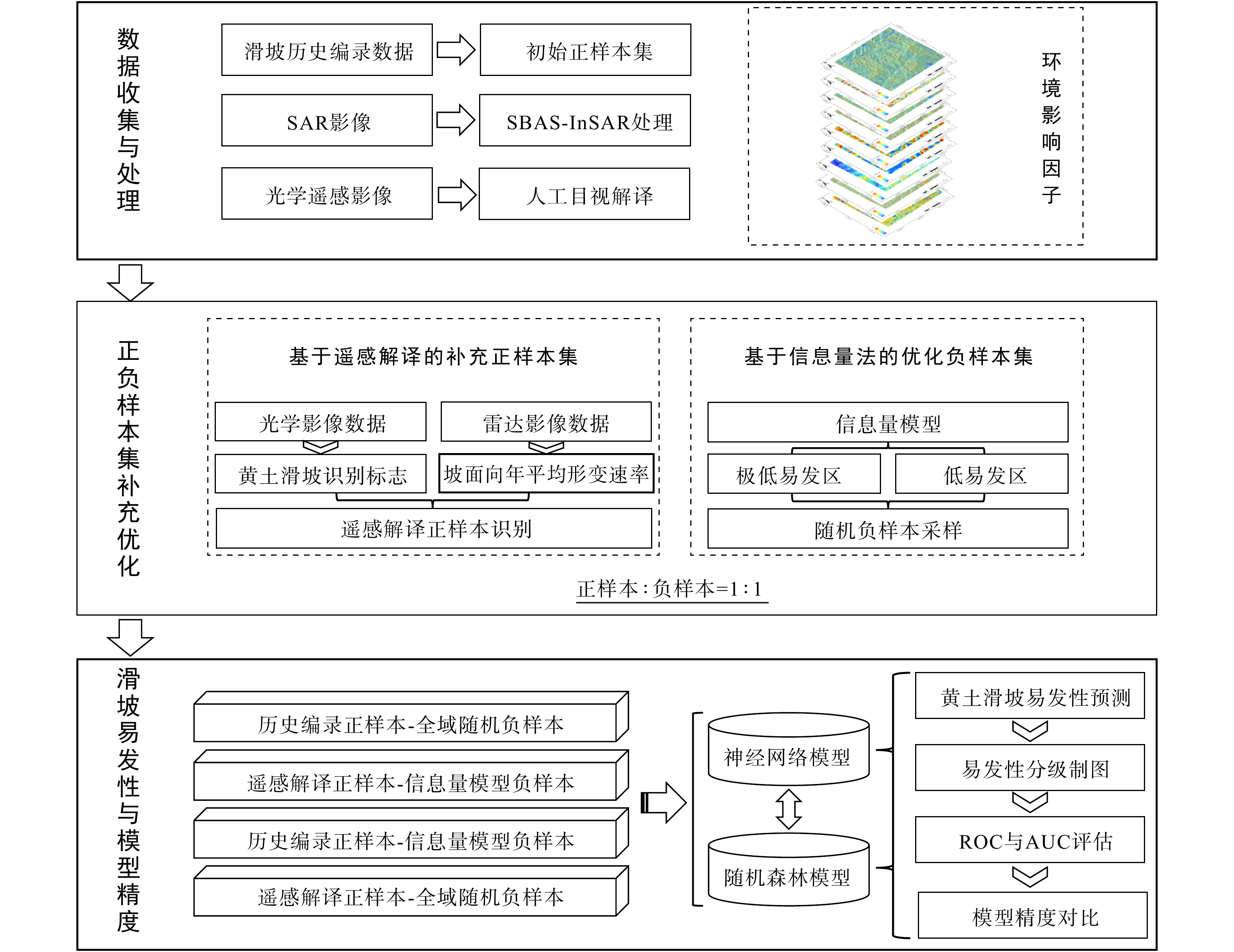
黄土高原黄土特殊的水敏性与垂直节理构造导致滑坡灾害高发频发,伴随特高压输电线路等线性基建大范围落地,区域精细化滑坡易发性评价需求持续攀升,但黄土偏远区域历史滑坡编录资料稀缺,传统依靠历史台账获取正样本、全域随机抽取负样本的建模方式,存在正样本数量不足、负样本易混入同环境模糊样本的弊端,造成机器学习模型评价精度偏低。针对上述问题,提出一种融合小基线子集合成孔径雷达干涉测量(SBAS-InSAR)时序遥感解译与信息量统计法的滑坡正负样本协同优化方法。以山西临汾吕梁山沿线黄土区为对象,选取高程、坡度、坡向、归一化植被指数(NDVI)、沟壑密度等 9 项评价因子开展建模;依托 2023—2024 年 Sentinel-1A 卫星影像实施 SBAS-InSAR 形变反演,将年形变速率≤−15 mm/a 区域划为潜在滑坡区,结合光学影像滑坡地貌目视解译交叉核验,在原有历史滑坡扩充的 230 个栅格正样本基础上新增 920 个栅格样本,得到
1150 个优化正样本;再利用信息量模型开展滑坡易发性五级分区,从极低、低易发区内随机采样获取优化负样本,严格控制正负样本 1∶1 配比。试验设置 4 组对照采样方案,数据集按 7∶3 划分训练与测试集,采用随机森林(RF)与反向传播神经网络(BP)开展易发性建模,以受试者工作特征曲线−曲线下面积(ROC-AUC)作为精度评价指标。结果表明,样本优化效果分级显著:仅优化正样本可明显提升模型精度,仅优化负样本对模型增益有限,正负样本协同优化效果最优;最优方案 RF、BP 模型 AUC 分别为0.91812 ,0.81937 ,相较传统 “历史编录正样本+全域随机负样本” 方案(RF、BP 模型 AUC 分别为0.57285 ,0.55577 ),精度分别提升 60.27%,47.43%。研究证实遥感与信息量法协同优化样本可显著提升黄土滑坡评价可靠性,该思路可推广至红层山区等样本匮乏区域,能够为黄土区输电线路安全运维与地质灾害防控提供技术依据。Abstract:ObjectiveLoess distributed across the Loess Plateau is characterized by prominent water sensitivity, collapsibility, and well-developed vertical joints, making regional landslides frequently triggered by rainfall infiltration, freeze-thaw cycles, and intensive human engineering activities. With the large-scale construction of ultra-high-voltage power transmission infrastructure in mountainous loess terrain, refined landslide susceptibility assessment has become an essential prerequisite for engineering safety management. However, remote hilly loess regions generally suffer from incomplete historical landslide inventories. Conventional sampling strategies obtain positive samples merely from archived landslide records and extract negative samples randomly across the entire study area. Such sampling patterns lead to insufficient positive samples and contaminated negative samples mixed with ambiguous non-landslide grids that share similar geological settings, which seriously degrades the prediction performance of machine learning-based susceptibility models. To solve this technical bottleneck, this study proposes a collaborative optimization strategy for positive and negative landslide samples by integrating time-series small baseline subset interferometric synthetic aperture radar (SBAS-InSAR) remote sensing interpretation and the information value method.
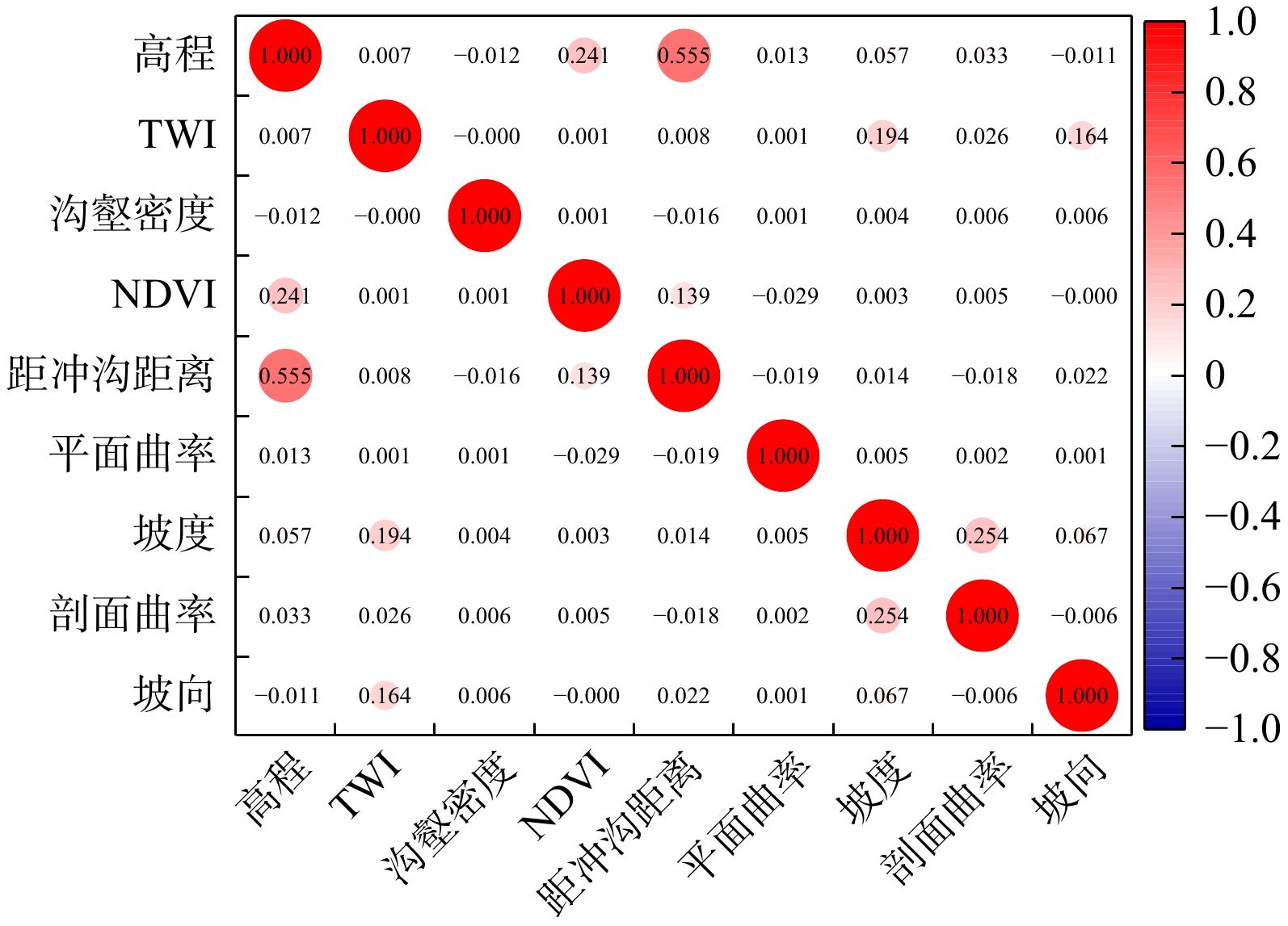
MethodsThe study area was located at the southern foot of Lyuliang Mountain in Linfen, Shanxi Province, covering a total area of 189.62 km2 with typical loess ridge-gully geomorphology. Nine assessment factors closely related to loess landslide initiation were selected for susceptibility modeling: elevation, slope gradient, slope aspect, plan curvature, profile curvature, topographic wetness index (TWI), normalized difference vegetation index (NDVI), gully density, and distance to gullies. Based on Sentinel-1A ascending SAR images collected from March 2023 to June 2024, SBAS-InSAR deformation inversion was implemented, and grid cells with annual sliding deformation rate ≤ −15 mm/a were preliminarily defined as potential unstable landslide zones. Combined with visual interpretation of typical geomorphic features such as cirque-shaped scarps from high-resolution optical remote sensing images, dual verification was conducted to screen reliable positive samples. Specifically, 230 raster positive samples were expanded from 10 historically recorded landslides, and another 920 supplementary raster samples were identified from 31 newly detected hidden landslides, forming a final positive dataset consisting of 1 150 grid cells. Subsequently, the information value model was adopted to classify the entire study area into five susceptibility grades via the natural breaks algorithm, and qualified negative samples were randomly selected only from extremely low and low susceptibility zones with a fixed 1:1 positive-to-negative sample ratio. Four comparative sampling schemes were constructed for quantitative comparison, and all datasets were randomly split into training and testing subsets at a ratio of 7:3. Random forest (RF) and back propagation neural network (BP) were employed to establish landslide susceptibility models, and the area under the receiver operating characteristic curve (ROC-AUC) was adopted as the quantitative assessment indicator of model accuracy.
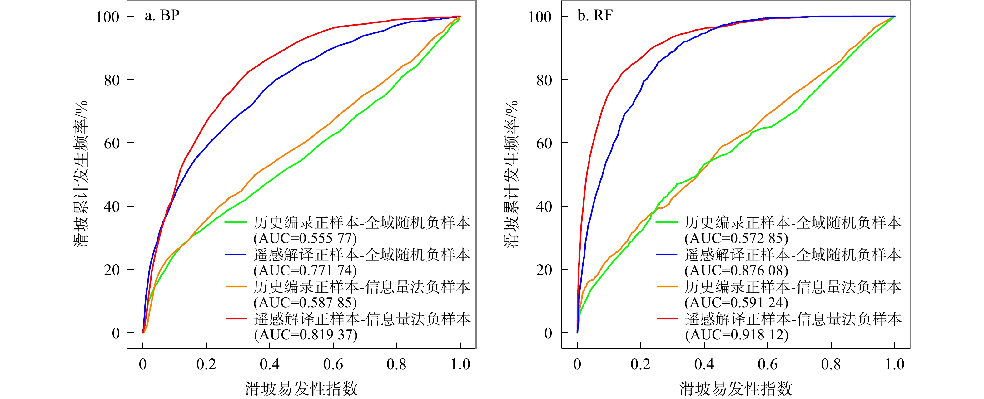
ResultsThe modeling results revealed an obvious hierarchical improvement effect. Optimizing only positive samples greatly improved model accuracy, with AUC values reaching
0.87608 (RF) and0.77174 (BP), while independent negative sample optimization brought limited accuracy improvement, with AUC values of0.59124 (RF) and0.58785 (BP). The collaborative optimization scheme combining remote-sensing-derived positive samples and information-value-filtered negative samples achieved optimal performance, with RF-AUC =0.91812 and BP-AUC =0.81937 , representing accuracy improvements of 60.27% and 47.43%, respectively, compared with the traditional sampling scheme (RF-AUC =0.57285 , BP-AUC =0.55577 ).ConclusionThis study verifies that the proposed hybrid sample optimization framework can significantly improve the reliability of loess landslide susceptibility assessment. The core technical idea can be extended to other data-deficient regions such as red-bed hilly terrains and alpine canyon areas, providing solid technical support for geological disaster prevention and safe operation of major power transmission projects on the Loess Plateau.
-
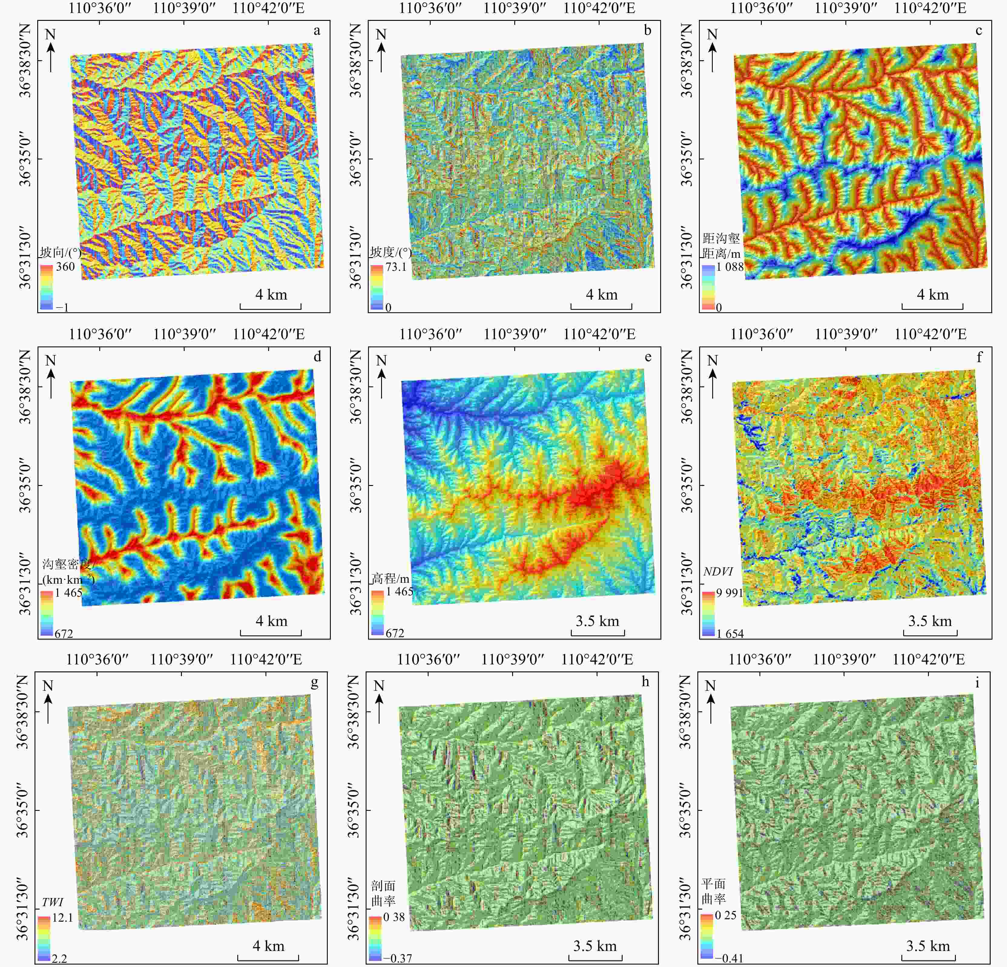
图 1 研究区滑坡易发性评价因子分布
TWI为地形湿度指数;NDVI为归一化植被指数;下同
Figure 1. Distribution of landslide susceptibility assessment factors in study area

图 3 滑坡正负样本优化技术框架
SAR为合成孔径雷达;SBAS⁃InSAR为小基线集合成孔径雷达干涉测量;ROC为受试者工作特征曲线;AUC为曲线下面积
Figure 3. Technical framework of landslide positive-negative sample optimization
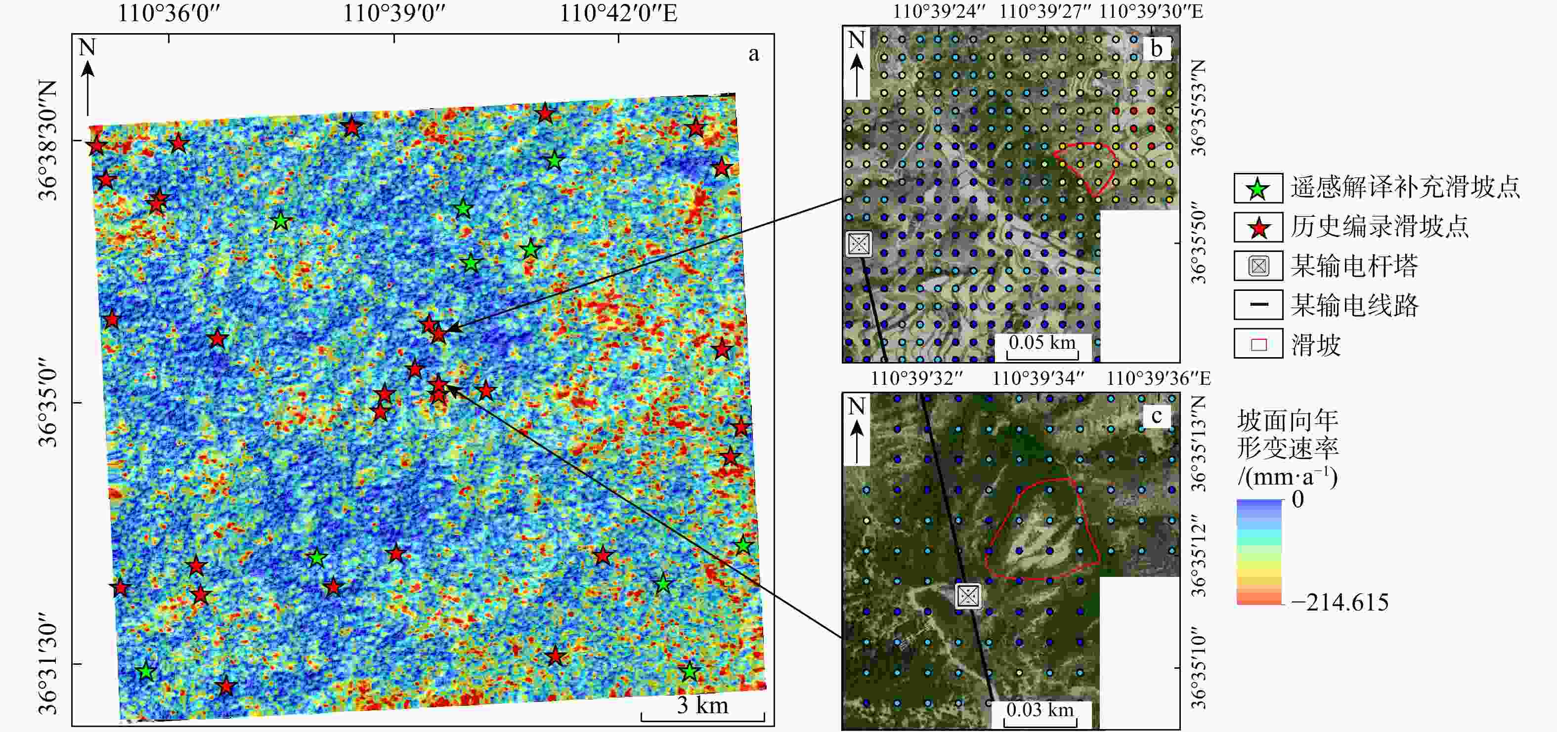
图 4 基于遥感解译的正样本补充结果
a. 研究区年形变速率分布图;b. 典型滑坡点1光学影像;c. 典型滑坡点2光学影像
Figure 4. Positive sample supplementary results based on remote sensing interpretation
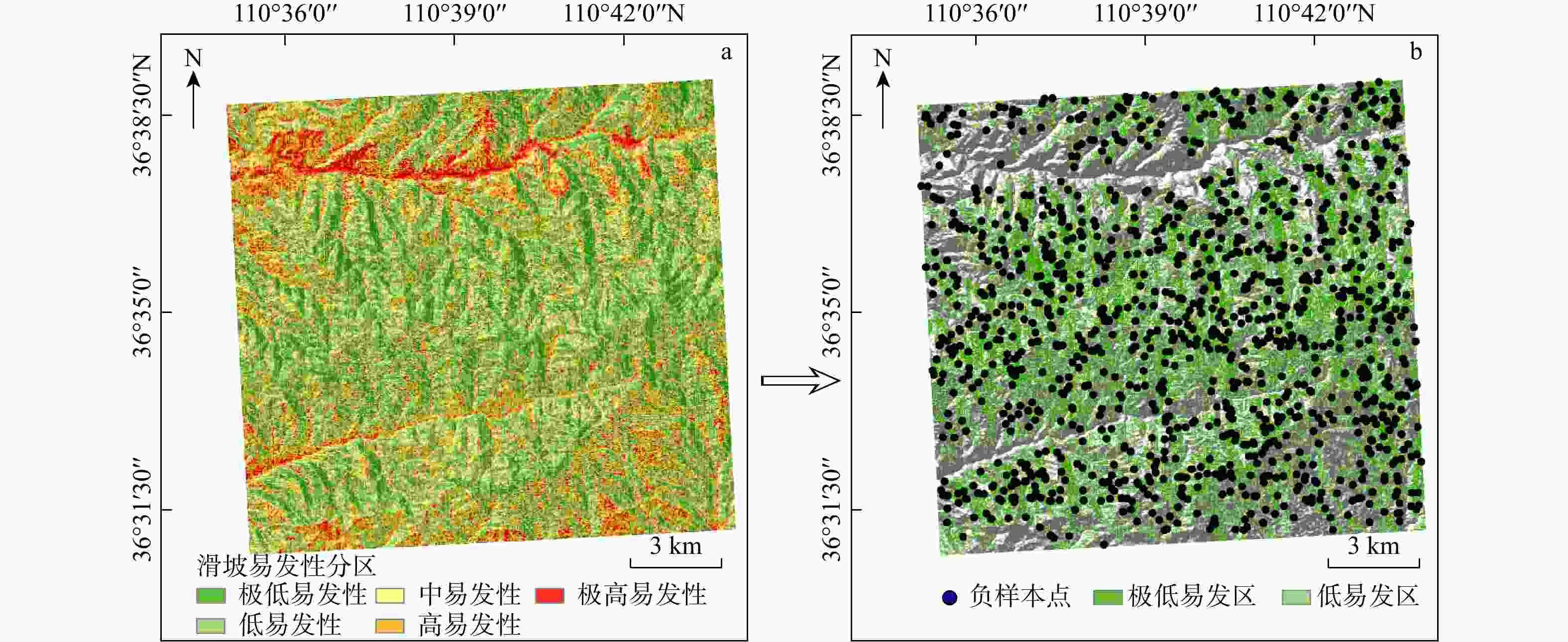
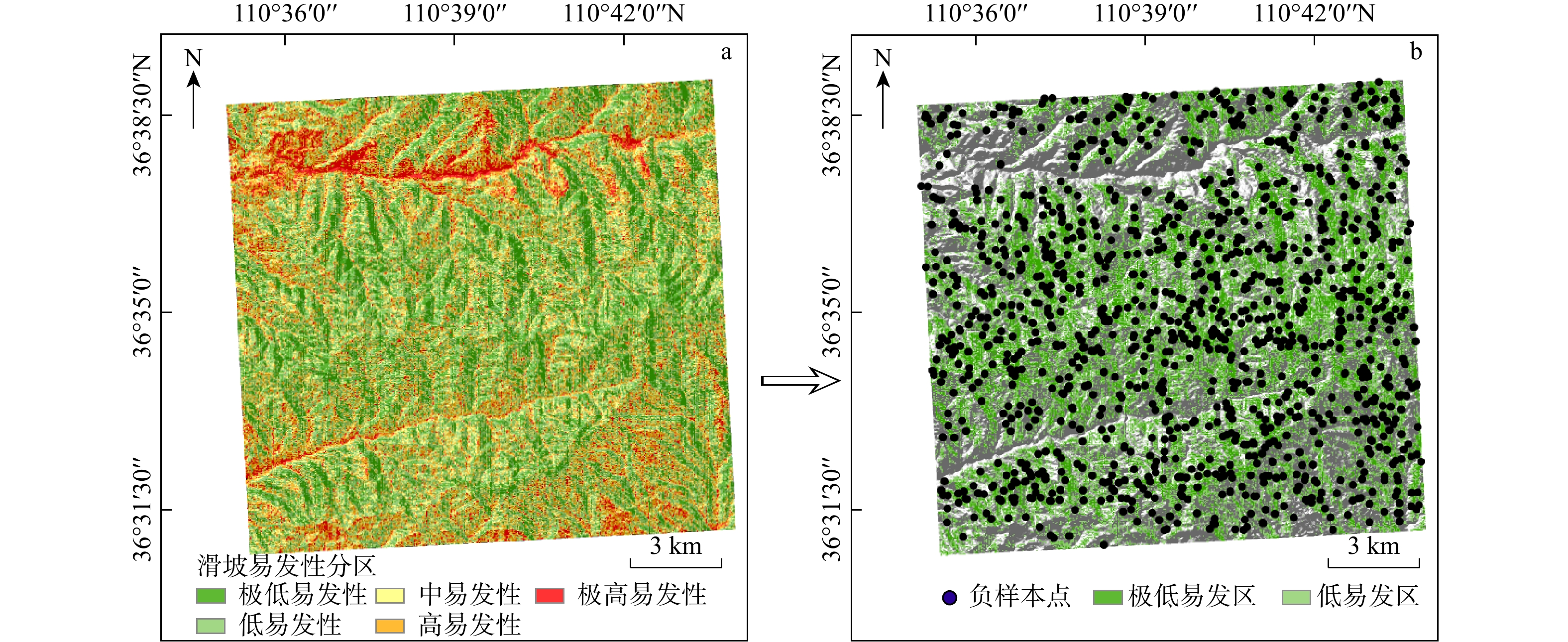
图 5 基于信息量模型的负样本优化采样结果
Figure 5. Negative sample optimization sampling results based on information model
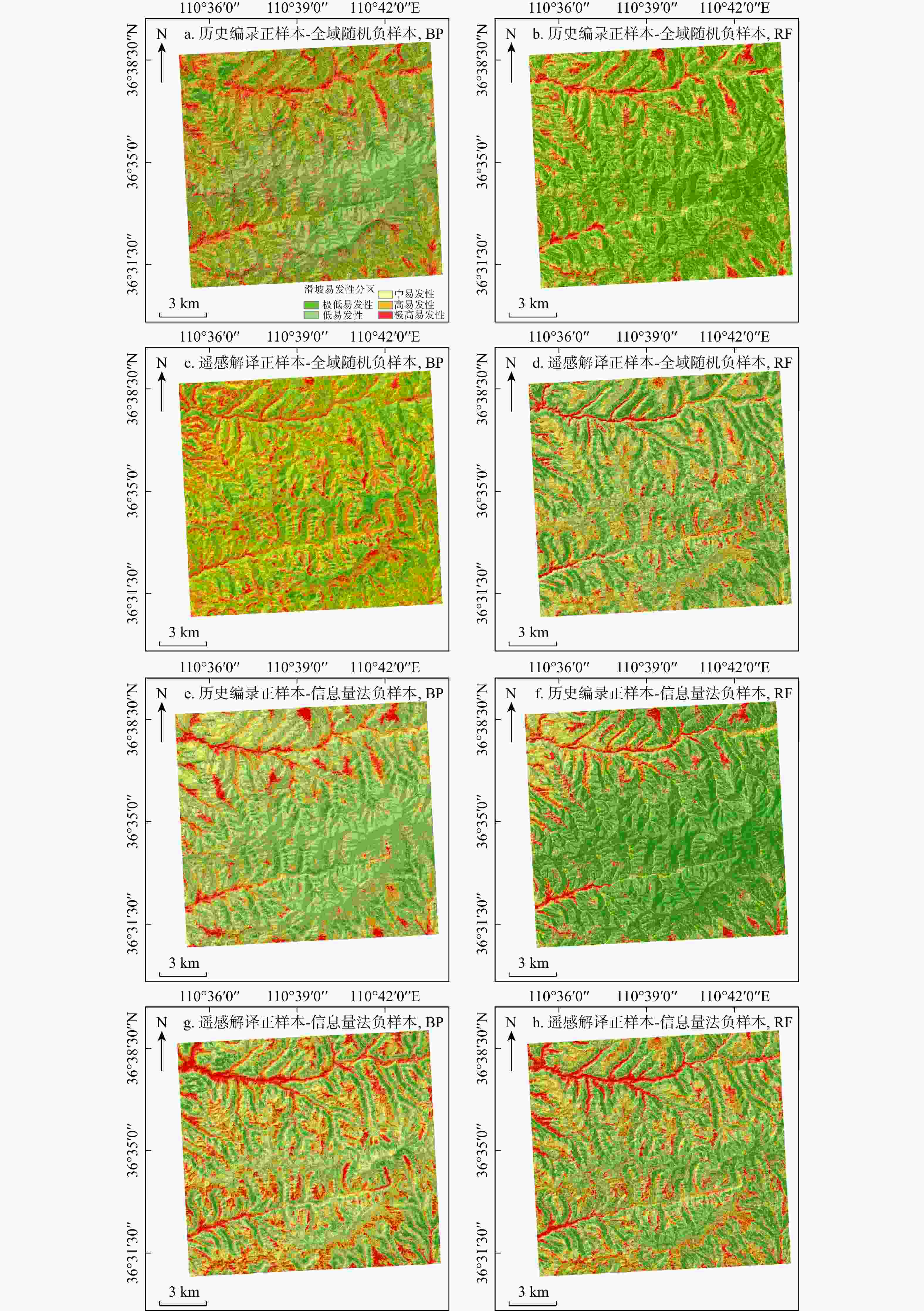
图 6 基于不同采样方案的滑坡易发性分区图
Figure 6. Landslide susceptibility zoning maps based on different sampling schemes
表 1 基于不同采样方案的滑坡正负样本集
Table 1. Landslide positive-negative sample datasets based on different sampling methods
滑坡正负样本采样方案 正样本数量/个 负样本数量/个 总计/个 历史编录正样本−全域随机负样本 230 230 460 遥感解译正样本−全域随机负样本 1150 1150 2300 历史编录正样本−信息量法负样本 230 230 460 遥感解译正样本−信息量法负样本 1150 1150 2300  下载: 导出CSV
-
[1] 彭建兵, 林鸿州, 王启耀, 等. 黄土地质灾害研究中的关键问题与创新思路[J]. 工程地质学报, 2014, 22(4): 684-691.PENG J B, LIN H Z, WANG Q Y, et al. The critical issues and creative concepts in mitigation research of loess geological hazards[J]. Journal of Engineering Geology, 2014, 22(4): 684-691. (in Chinese with English abstract [2] DERBYSHIRE E. Geological hazards in loess terrain, with particular reference to the loess regions of China[J]. Earth-Science Reviews, 2001, 54(1/2/3): 231-260. doi: 10.1016/s0012-8252(01)00050-2 [3] 张茂省, 胡炜, 孙萍萍, 等. 黄土水敏性及水致黄土滑坡研究现状与展望[J]. 地球环境学报, 2016, 7(4): 323-334.ZHANG M S, HU W, SUN P P, et al. Advances and prospects of water sensitivity of loess and the induced loess landslides[J]. Journal of Earth Environment, 2016, 7(4): 323-334. (in Chinese with English abstract [4] 王新刚, 余宏明, 胡斌, 等. 节理控制的降雨入渗通道对黄土开挖边坡稳定性的影响[J]. 山地学报, 2013, 31(4): 413-417.WANG X G, YU H M, HU B, et al. Influence of joint-controlled rainfall infiltration channels on the stability of loess excavation slopes[J]. Mountain Research, 2013, 31(4): 413-417. (in Chinese with English abstract [5] 王新刚, 刘凯, 黄强兵, 等. 黄土高原地质灾害链发育特征及其分类体系[J]. 地球科学, 2026, 51(4): 1437-1462.WANG X G, LIU K, HUANG Q B, et al. Development characteristics and classification system of geological disaster chains on Loess Plateau[J]. Earth Science, 2026, 51(4): 1437-1462. (in Chinese with English abstract [6] 薛强, 唐亚明, 白轩. 吕梁山区大宁县城地质灾害破坏模式及风险管控[J]. 山地学报, 2021, 39(1): 151-162.XUE Q, TANG Y M, BAI X. Failure modes and risk control of geohazards in the county town of Daning in the Lyuliang mountains, China[J]. Mountain Research, 2021, 39(1): 151-162. (in Chinese with English abstract [7] 孔嘉旭, 庄建琦, 彭建兵, 等. 基于信息量和卷积神经网络的黄土高原滑坡易发性评价[J]. 地球科学, 2023, 48(5): 1711-1729.KONG J X, ZHUANG J Q, PENG J B, et al. Landslide susceptibility assessment on the Loess Plateau based on information value and convolutional neural network[J]. Earth Science, 2023, 48(5): 1711-1729. (in Chinese with English abstract [8] 洪浩源, 王德生, 朱阿兴. 面向机器学习型区域滑坡易发性评价的训练样本采样方法[J]. 地理学报, 2024, 79(7): 1718-1736.HONG H Y, WANG D S, ZHU A X. A new training data sampling method for machine learning-based landslide susceptibility mapping[J]. Acta Geographica Sinica, 2024, 79(7): 1718-1736. (in Chinese with English abstract [9] 刘雅婷, 陈传法, 何青鑫, 等. 顾及正负样本优化的滑坡易发性评价[J]. 测绘学报, 2025, 54(2): 308-320.LIU Y T, CHEN C F, HE Q X, et al. Landslide susceptibility evaluation considering positive and negative sample optimization[J]. Acta Geodaetica et Cartographica Sinica, 2025, 54(2): 308-320. (in Chinese with English abstract [10] 王启盛, 熊俊楠, 程维明, 等. 耦合统计方法、机器学习模型和聚类算法的滑坡易发性评价方法[J]. 地球信息科学学报, 2024, 26(3): 620-637.WANG Q S, XIONG J N, CHENG W M, et al. Landslide susceptibility mapping methods coupling with statistical methods, machine learning models and clustering algorithms[J]. Journal of Geo-Information Science, 2024, 26(3): 620-637. (in Chinese with English abstract [11] 陆昊, 卢书强, 李佳乐, 等. 可解释性结合多算法优化BP模型的滑坡易发性评价[J]. 中国地质灾害与防治学报, 2025, 36(4): 160-174.LU H, LU S Q, LI J L, et al. Interpretable landslide susceptibility evaluation using a BP neural network model optimized by multiple algorithms[J]. The Chinese Journal of Geological Hazard and Control, 2025, 36(4): 160-174. (in Chinese with English abstract [12] 何一飞, 张耀南. 滑坡数据不完整对易发性建模的影响及改进建议[J]. 数据与计算发展前沿, 2025, 7(1): 186-202.HE Y F, ZHANG Y N. Influence of incomplete landslide data on susceptibility modeling and suggestions for improvement[J]. Frontiers of Data& Computing, 2025, 7(1): 186-202. (in Chinese with English abstract [13] COLESANTI C, WASOWSKI J. Investigating landslides with space-borne synthetic aperture radar (SAR) interferometry[J]. Engineering Geology, 2006, 88(3/4): 173-199. [14] HOOPER A, BEKAERT D, SPAANS K, et al. Recent advances in SAR interferometry time series analysis for measuring crustal deformation[J]. Tectonophysics, 2012, 514: 1-13. [15] 许冲, 徐锡伟, 吴熙彦, 等. 2008年汶川地震滑坡详细编目及其空间分布规律分析[J]. 工程地质学报, 2013, 21(1): 25-44.XU C, XU X W, WU X Y, et al. Detailed catalog of landslides triggered by the 2008 Wenchuan earthquake and statistical analyses of their spatial distribution[J]. Journal of Engineering Geology, 2013, 21(1): 25-44. (in Chinese with English abstract [16] 弓永峰, 王辉, 吴学华, 等. 基于时序InSAR的宁夏西吉县滑坡灾害隐患识别[J]. 安全与环境工程, 2022, 29(6): 114-121.GONG Y F, WANG H, WU X H, et al. Identification of potential landslide hazards using time-series InSAR in Xiji County of Ningxia[J]. Safety and Environmental Engineering, 2022, 29(6): 114-121. (in Chinese with English abstract [17] LU P, CASAGLI N, CATANI F, et al. Persistent scatterers interferometry hotspot and cluster analysis (PSI-HCA) for detection of extremely slow-moving landslides[J]. International Journal of Remote Sensing, 2012, 33(2): 466-489. [18] 武雪玲, 杨经宇, 牛瑞卿. 一种结合SMOTE和卷积神经网络的滑坡易发性评价方法[J]. 武汉大学学报(信息科学版), 2020, 45(8): 1223-1232.WU X L, YANG J Y, NIU R Q. A landslide susceptibility assessment method combining SMOTE and convolutional neural network[J]. Geomatics and Information Science of Wuhan University, 2020, 45(8): 1223-1232 . (in Chinese with English abstract [19] 龚屿, 刘晓. 非滑坡样本选择对滑坡易发性评价的影响研究: 以汶川县、理县和茂县为例[J]. 中国地质灾害与防治学报, 2025, 36(3): 129-139.GONG Y, LIU X. Analyzing the influence of non-landslide sample selection on landslide susceptibility: Case studies from Wenchuan, Lixian and Maoxian counties[J]. The Chinese Journal of Geological Hazard and Control, 2025, 36(3): 129-139. (in Chinese with English abstract [20] BRENNING A. Spatial prediction models for landslide hazards: Review, comparison and evaluation[J]. Natural Hazards and Earth System Sciences, 2005, 5(6): 853-862. [21] GRECO R, SORRISO-VALVO M. Influence of management of variables, sampling zones and land units on LR analysis for landslide spatial prevision[J]. Natural Hazards and Earth System Sciences, 2013, 13(9): 2209-2221. [22] 周晓亭, 黄发明, 吴伟成, 等. 基于耦合信息量法选择负样本的区域滑坡易发性预测[J]. 工程科学与技术, 2022, 54(3): 25-35.ZHOU X T, HUANG F M, WU W C, et al. Regional landslide susceptibility prediction based on negative sample selected by coupling information value method[J]. Advanced Engineering Sciences, 2022, 54(3): 25-35. (in Chinese with English abstract [23] 周超, 甘露露, 王悦, 等. 综合非滑坡样本选取指数与异质集成机器学习的区域滑坡易发性建模[J]. 地球信息科学学报, 2023, 25(8): 1570-1585.ZHOU C, GAN L L, WANG Y, et al. Landslide susceptibility prediction based on non-landslide samples selection and heterogeneous ensemble machine learning[J]. Journal of Geo-Information Science, 2023, 25(8): 1570-1585. (in Chinese with English abstract [24] LIU L L, ZHANG Y L, XIAO T, et al. A frequency ratio-based sampling strategy for landslide susceptibility assessment[J]. Bulletin of Engineering Geology and the Environment, 2022, 81(9): 360. [25] 周志华, 郑志文, 孙传耕, 等. 粤北地区非滑坡样本选择策略分析与滑坡易发性评价[J/OL]. 安全与环境工程: 1-18[2026-06-04]. https://doi.org/10.13578/j.cnki.issn.1671-1556.20250684.ZHOU Z H, ZHENG Z W, SUN C G, et al. Analysis of non-landslide sample selection strategies and landslide susceptibility assessment in northern Guangdong[J/OL]. Safety and Environmental Engineering: 1-18[2026-06-04]. https://doi.org/10.13578/j.cnki.issn.1671-1556.20250684. (in Chinese with English abstract [26] DAI F C, LEE C F, NGAI Y Y. Landslide risk assessment and management: An overview[J]. Engineering Geology, 2002, 64(1): 65-87. [27] REICHENBACH P, ROSSI M, MALAMUD B D, et al. A review of statistically-based landslide susceptibility models[J]. Earth-Science Reviews, 2018, 180: 60-91. [28] 李家达. 黄土滑坡稳定性分析及失稳破坏过程模拟研究[D]. 北京: 中国地质大学(北京), 2021.LI J D. Stability analysis and instability failure process simulation of loess landslides[D]. Beijing: China University of Geosciences (Beijing), 2021. (in Chinese with English abstract [29] 黄发明, 刘科技, 曾子强, 等. 环境因子筛选及组合方法对滑坡易发性预测的影响规律[J]. 应用基础与工程科学学报, 2024, 32(1): 49-71.HUANG F M, LIU K J, ZENG Z Q, et al. Influence of environmental factor selection and combination on landslide susceptibility prediction modeling[J]. Journal of Basic Science and Engineering, 2024, 32(1): 49-71. (in Chinese with English abstract [30] ZHAO F C, MIAO F S, WU Y P, et al. Landslide dynamic susceptibility mapping in urban expansion area considering spatiotemporal land use and land cover change[J]. Science of the Total Environment, 2024, 949: 175059. [31] 秦佳松, 李为乐, 周胜森, 等. 考虑InSAR地表形变的滑坡易发性评价负样本选取与结果优化[J/OL]. 武汉大学学报(信息科学版): 1-18[2026-06-04]. https://doi.org/10.13203/j.whugis20240494.QIN J S, LI W L, ZHOU S S, et al. Negative sample selection and result optimization for landslide susceptibility assessment considering InSAR surface deformation[J/OL]. Geomatics and Information Science of Wuhan University: 1-18[2026-06-04]. https://doi.org/10.13203/j.whugis20240494. (in Chinese with English abstract [32] BERARDINO P, FORNARO G, LANARI R, et al. A new algorithm for surface deformation monitoring based on small baseline differential SAR interferograms[J]. IEEE Transactions on Geoscience and Remote Sensing, 2002, 40(11): 2375-2383. [33] 周超. 集成时间序列InSAR技术的滑坡早期识别与预测研究[D]. 武汉: 中国地质大学(武汉), 2018.ZHOU C. Research on early identification and prediction of landslides integrated with time-series InSAR technology[D]. Wuhan: China University of Geosciences(Wuhan), 2018. (in Chinese with English abstract [34] 汪鹏宇. 基于深度学习的滑坡遥感影像样本库构建与智能识别[D]. 广西桂林: 桂林理工大学, 2025.WANG P Y. Construction of a landslide remote sensing image sample database and intelligent recognition based on deep learning[D]. Guilin Guangxi: Guilin University of Technology, 2025. (in Chinese with English abstract [35] 陈志波, 李鼎兴, 陈澄, 等. 基于机器学习和InSAR技术的滑坡易发性动态评价[J]. 自然灾害学报, 2025, 34(2): 56-65.CHEN Z B, LI D X, CHEN C, et al. Dynamic evaluation of landslide susceptibility based on machine learning and InSAR technology[J]. Journal of Natural Disasters, 2025, 34(2): 56-65. (in Chinese with English abstract [36] 陈飞, 蔡超, 李小双, 等. 基于信息量与神经网络模型的滑坡易发性评价[J]. 岩石力学与工程学报, 2020, 39(增刊1): 2859-2870.CHEN F, CAI C, LI X S, et al. Landslide susceptibility assessment based on information value and neural network model[J]. Chinese Journal of Rock Mechanics and Engineering, 2020, 39(S1): 2859-2870 . (in Chinese with English abstract [37] DENG H, WU X T, ZHANG W J, et al. Slope-unit scale landslide susceptibility mapping based on the random forest model in deep valley areas[J]. Remote Sensing, 2022, 14(17): 4245. [38] FAWCETT T. An introduction to ROC analysis[J]. Pattern Recognition Letters, 2006, 27(8): 861-874. -

 下载:
下载:


 点击查看大图

计量
- 文章访问数: 47
- PDF下载量: 6
- 被引次数: 0

