
 投审稿入口
投审稿入口

Indicative significance of gravity-magnetic wavelet multi-scale decomposition for deep mineral exploration: A case study of Chengchao iron deposit in southeastern Hubei Province
-
摘要:目的
鄂东南是我国重要铁矿资源基地,程潮铁矿作为区内典型大型矽卡岩型铁矿,现有钻探工程已达标高−
1300 m且矿体尚未完全圈闭,深部及外围找矿潜力突出。重磁勘探是磁铁矿勘查的高效手段,但传统位场分离算法参数依赖性强、弱异常提取效果有限,如何精准挖掘重磁异常中的深部矿化信息,是该区深部找矿亟待解决的问题。方法以程潮铁矿区及外围为研究区,基于 GMS 重磁勘探软件,选用 DB4 小波基开展重磁数据小波多尺度分解,结合功率谱法计算各阶细节异常对应的场源似深度;从平面、剖面两个维度,系统剖析不同深度磁、重力细节异常的强度、规模、正负异常组合及梯度变化特征,并结合钻探、大地电磁、物性测试等资料,建立异常与已知地质体、矿体的对应关系。
结果研究表明,从重磁一阶至四阶细节异常,异常强度随场源似深度增大持续升高,四阶异常幅值达到峰值,对应场源似深度约
1570 m;五阶细节异常强度略有衰减,但异常分布规模进一步扩大。目前矿区工程控制的磁铁矿体主要赋存于一至三阶细节异常对应的浅−中部深度区间,四阶强异常对应深度暂无工程揭露,反映矿区深部存在显著的高磁性、高密度地质体响应。结论小波多尺度分解技术可有效剥离不同深度的重磁局部异常,实现多维度精细解析。深部验证钻孔及测井资料已在
1600 m以深位置揭露工业磁铁矿体,刷新矿区最大见矿深度,证实该方法能够有效指导老矿山深边部隐伏矿体探测、地质组构解译,可为同类矽卡岩型铁矿区深部找矿工作提供可靠的技术参考。Abstract:ObjectiveAs a key iron ore base in China, southeastern Hubei Province hosts numerous large and medium-sized skarn-type iron deposits. The Chengchao iron deposit, one of the most representative large skarn-type iron mines in this region, has been explored intensively by drilling projects. The deepest existing engineering control has reached an elevation of −
1300 m, and the ore body has not been fully delineated, indicating great exploration potential in its deep and peripheral areas. High-grade iron ore is a strategic mineral resource in China, and gravity and magnetic prospecting have become efficient geophysical techniques for magnetite exploration. Nevertheless, traditional potential field separation methods are highly dependent on manual parameter selection and have limited capability in extracting weak deep-seated anomaly signals. Therefore, it is urgent to develop an effective technical means to accurately identify deep mineralization information from gravity-magnetic anomaly data for deep mineral exploration in the study area.MethodsThis study took the Chengchao iron deposit area and its surroundings as the research object. Based on the GMS gravity-magnetic exploration software, the DB4 wavelet basis was adopted to conduct wavelet multi-scale decomposition on collected gravity and magnetic data. The power spectrum analysis method was further applied to quantitatively calculate the apparent source depths corresponding to each order of wavelet detail anomalies. From planar and profile perspectives, this study systematically analyzed the intensity, scale, positive-negative anomaly combination, and gradient characteristics of magnetic and gravity detail anomalies at different depths. Combined with physical property test data, drilling records, and magnetotelluric sounding results, this study established the spatial correlation between geophysical anomalies and known geological bodies as well as iron ore bodies.
ResultsThe research results showed that the intensity of the first- to fourth-order wavelet detail anomalies increased continuously with the growth of apparent source depth, and the fourth-order anomalies reached the maximum amplitude with a corresponding apparent source depth of approximately
1570 m. Although the intensity of the fifth-order detail anomalies decreased slightly, their distribution range expanded significantly. At present, the magnetite ore bodies controlled by existing engineering works are mainly distributed in the shallow and middle zones corresponding to the first- to third-order detail anomalies. The strong fourth-order anomalies, however, have not been verified by deep drilling, indicating significant geophysical responses of high-density and high-magnetic geological bodies in the deep part of the mining area.ConclusionThis study verifies that wavelet multi-scale decomposition can effectively separate local gravity-magnetic anomalies at different depths and realize multi-dimensional refined interpretation. A deep verification borehole and logging data have uncovered industrial magnetite ore at depths below
1600 m, setting a new record of the deepest ore occurrence in the mining area. The proposed integrated technical workflow proves reliable for detecting concealed ore bodies and interpreting deep geological structures in old mines. It can also provide a solid technical reference for deep exploration of similar skarn-type iron deposits worldwide. -
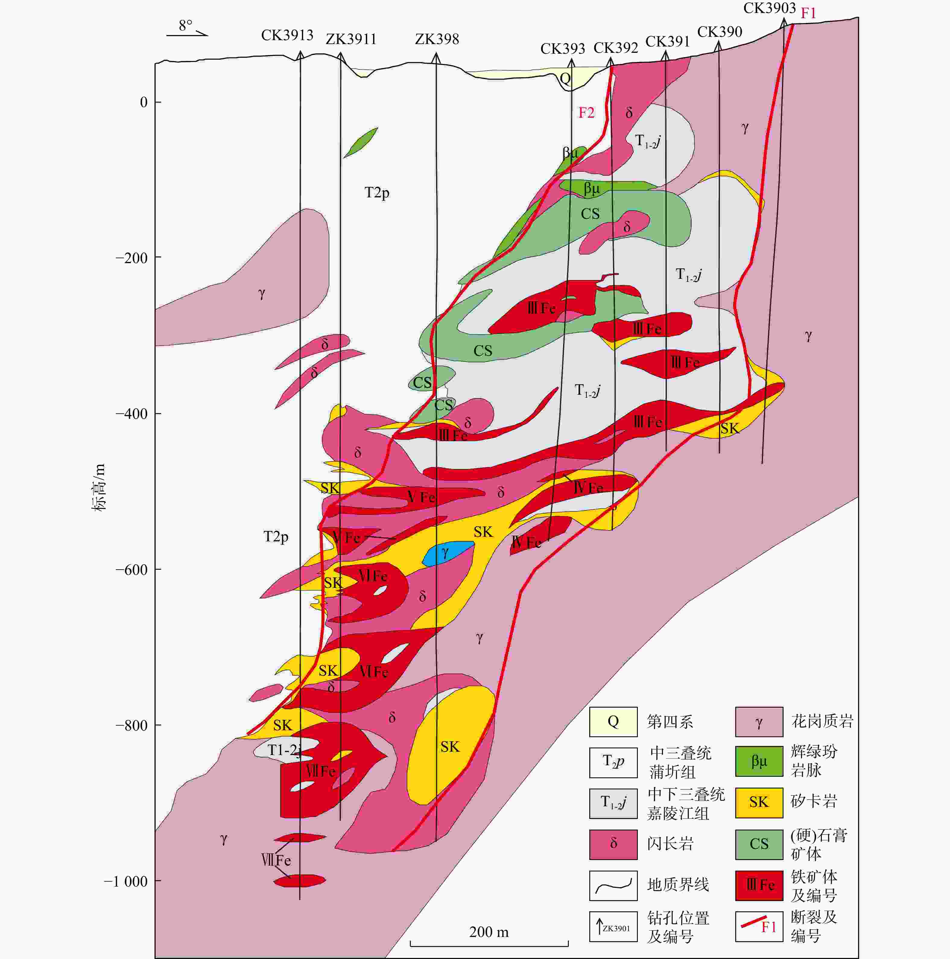
图 2 程潮铁矿床勘探线剖面图(据文献[48]改)
Figure 2. Profile of exploration line of Chengchao iron deposit
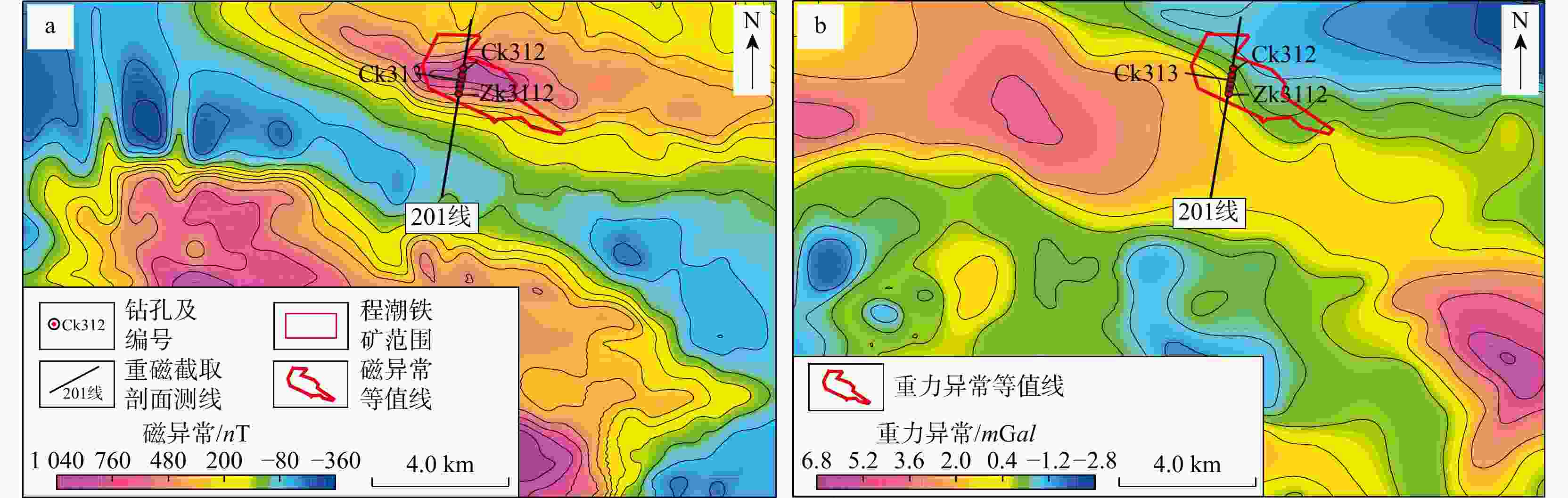
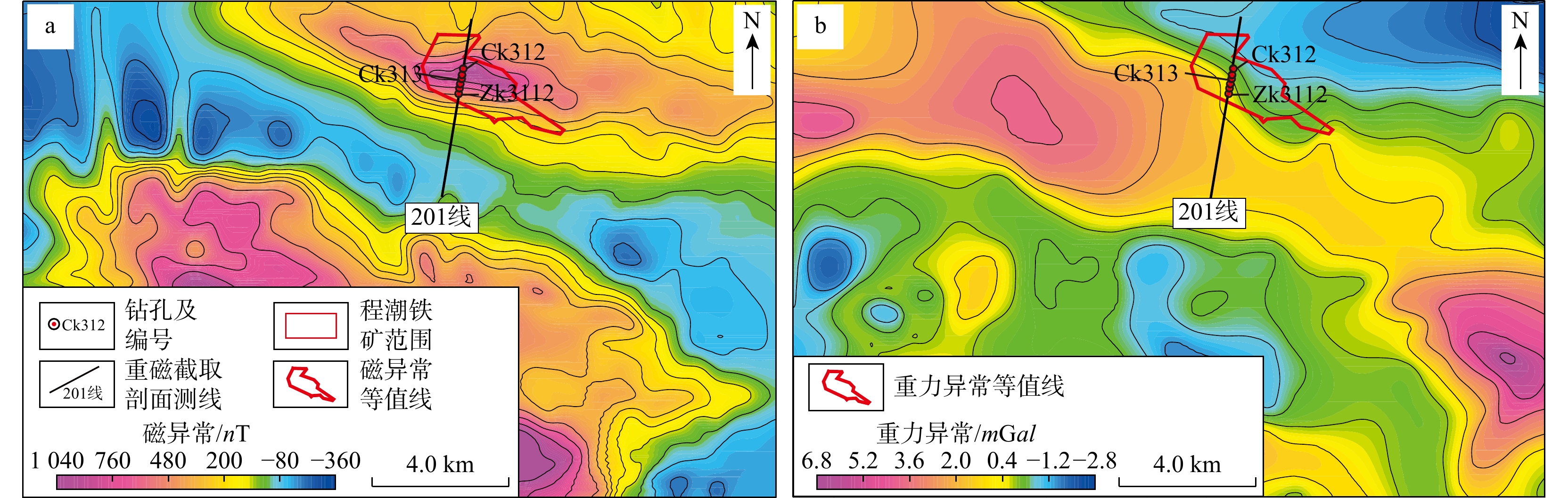
图 3 鄂城地区航磁化极(a)与布格剩余重力(b)等值线图
Figure 3. Contour maps of reduced-to-pole aeromagnetic anomaly (a) and Bouguer gravity residual (b) in Echeng area
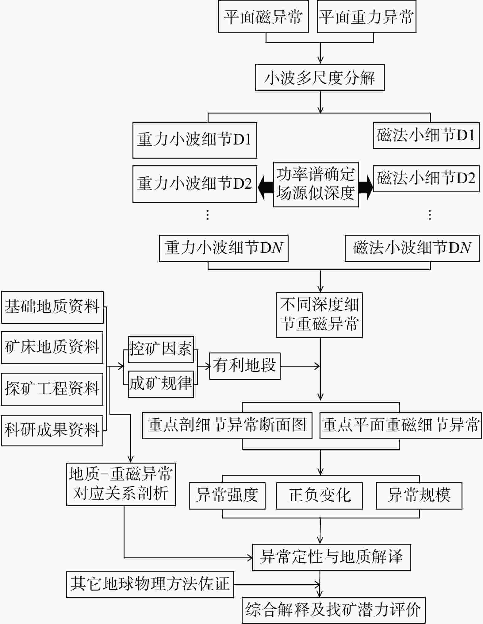
图 4 重磁异常小波多尺度分解结果多维度解析及评价流程
D1,D2,..... ,DN为第 1~N阶小波细节分量,N为小波分解的最大分解层数
Figure 4. Multi-dimensional analysis and evaluation workflow for wavelet multiscale decomposition results of gravity-magnetic anomalies
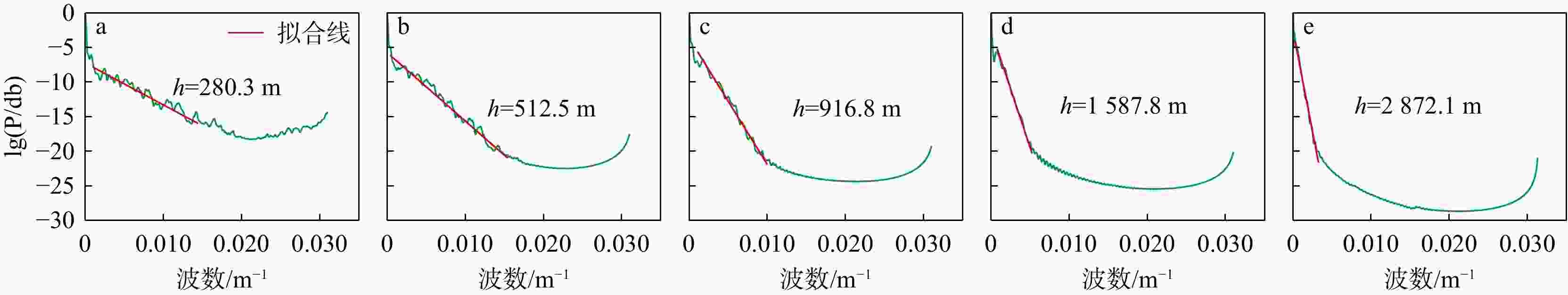
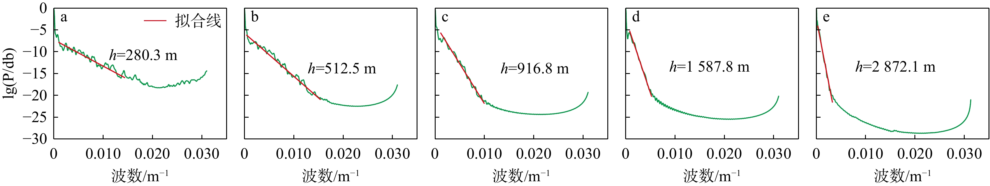
图 5 鄂城−铁山地区航磁化极异常小波多尺度分解结果的对数功率谱分析(h为深度;P为频率;下同)
Figure 5. Logarithmic power spectrum analysis of wavelet multiscale decomposition results of reduced-to-pole aeromagnetic anomalies in Echeng-Tieshan area
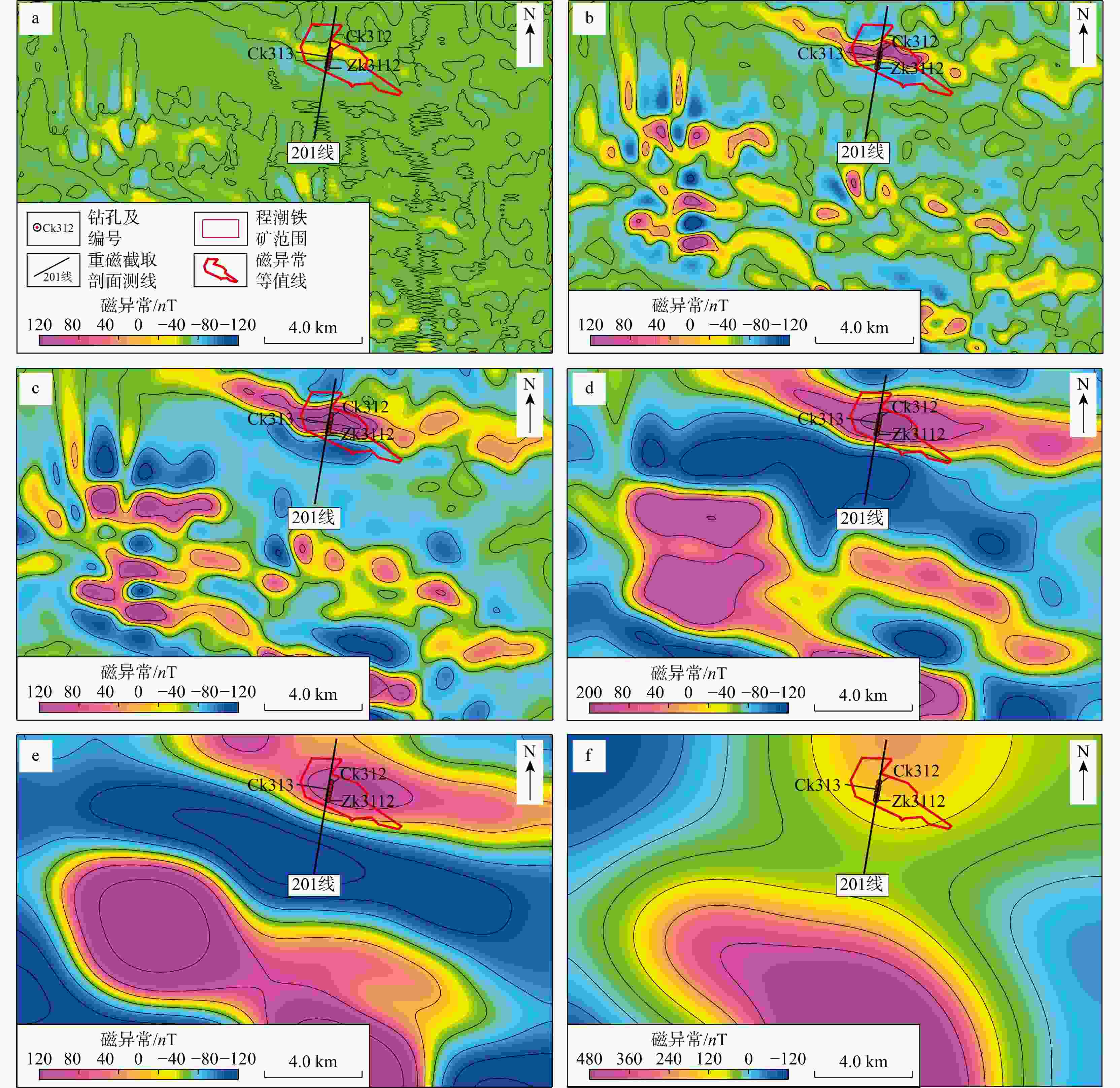
图 6 鄂城−铁山地区航磁化极异常小波多尺度分解结果
Figure 6. Wavelet multiscale decomposition results of reduced-to-pole aeromagnetic anomalies in Echeng-Tieshan area
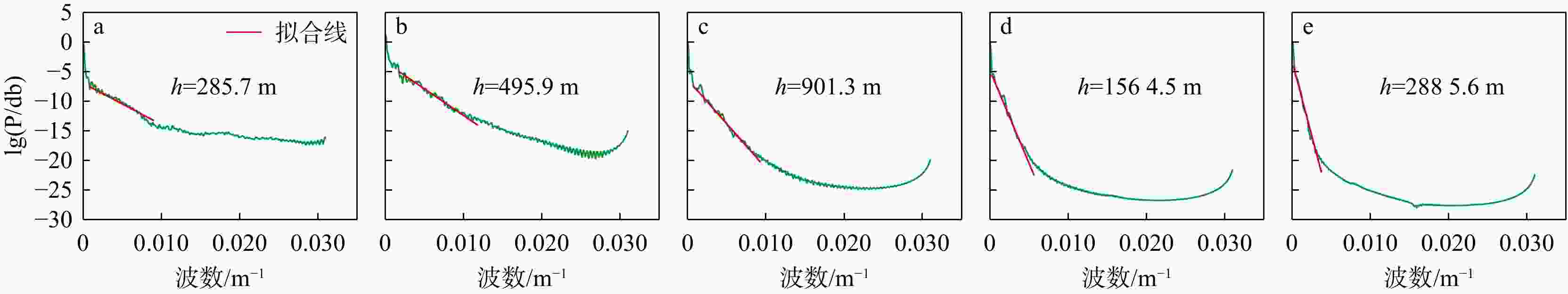
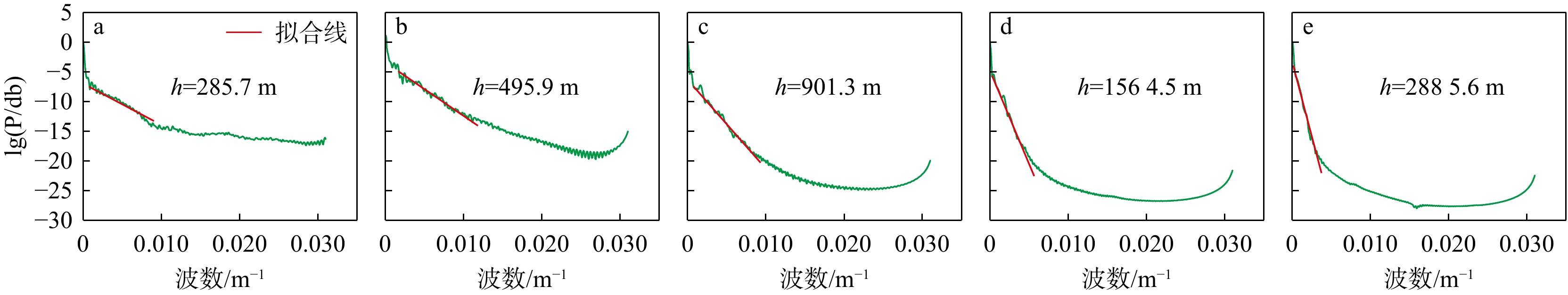
图 7 鄂城−铁山地区布格剩余重力异常小波多尺度分解结果的对数功率谱分析
Figure 7. Logarithmic power spectrum analysis of wavelet multiscale decomposition results of Bouguer residual gravity anomalies in Echeng-Tieshan area
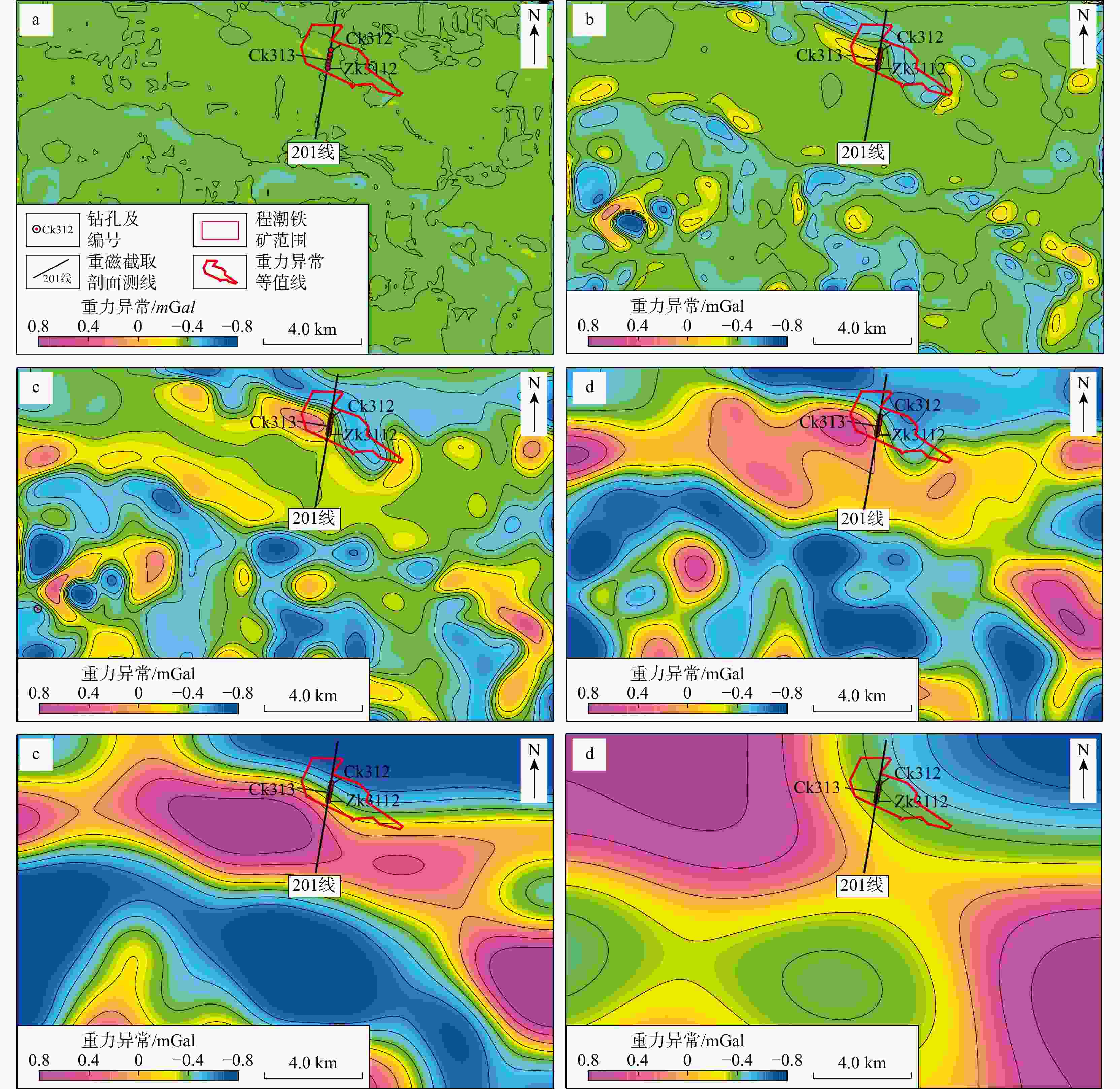
图 8 鄂城−铁山地区布格剩余重力异常小波多尺度分解结果
Figure 8. Wavelet multiscale decomposition results of Bouguer residual gravity anomalies in Echeng-Tieshan area
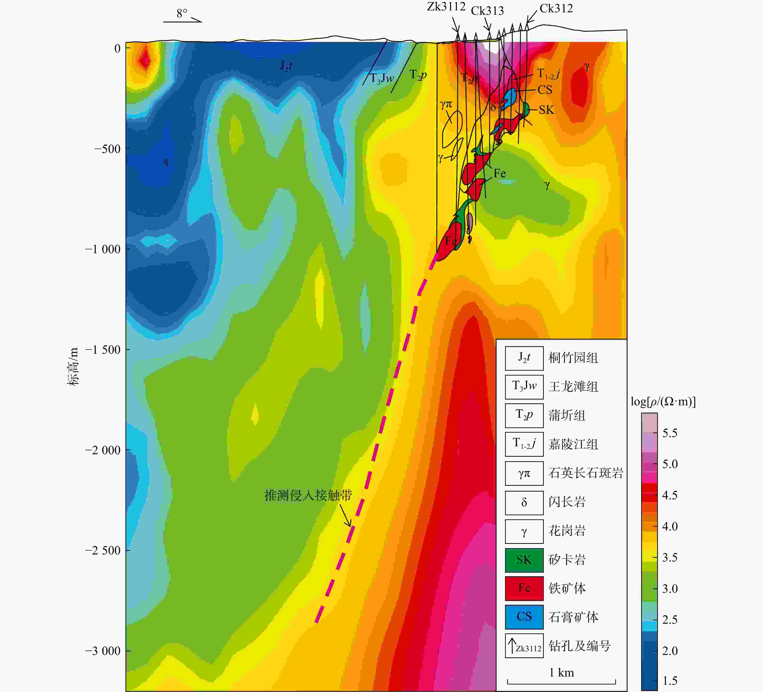
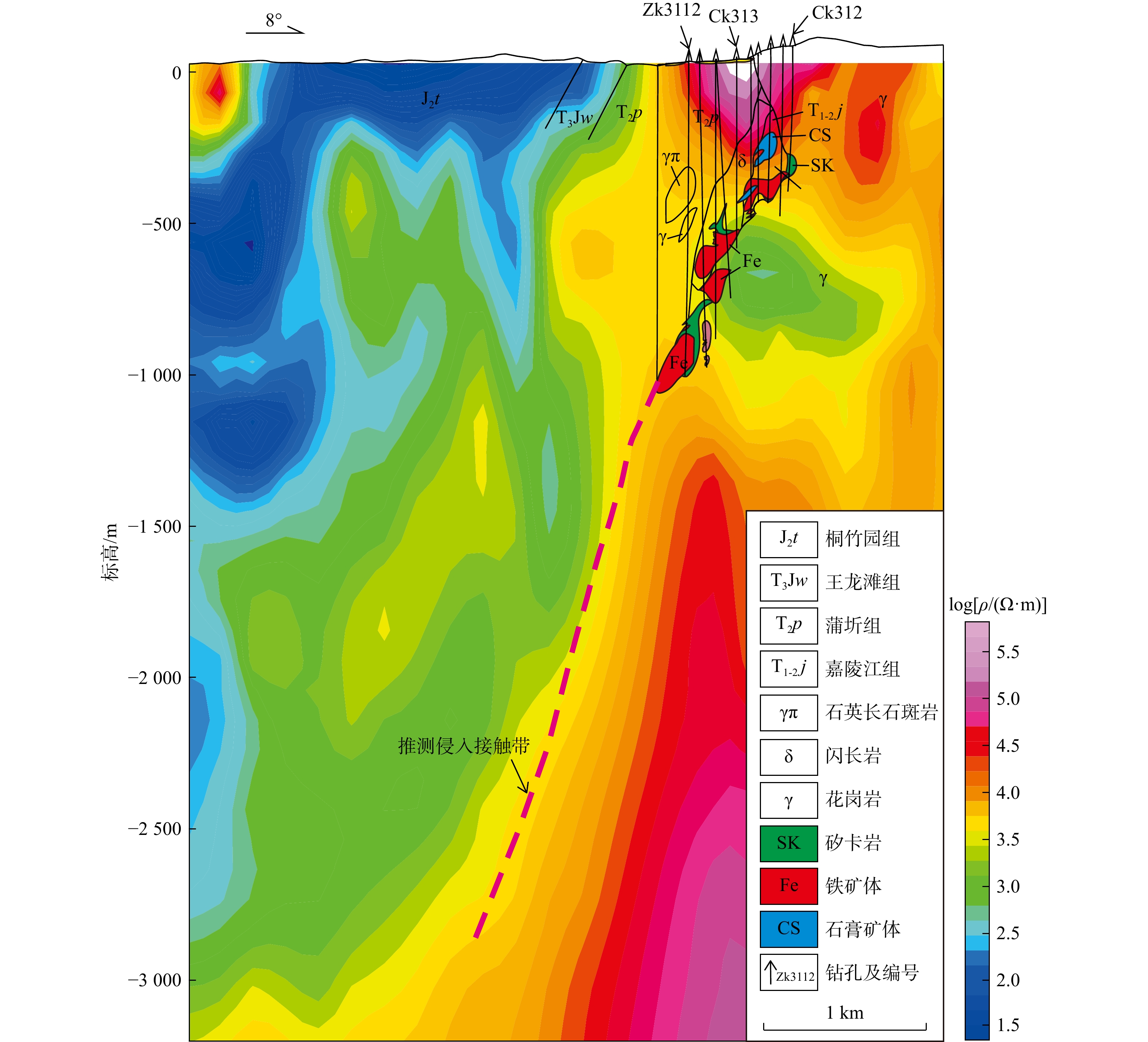
图 9 程潮铁矿区201线大地电磁法二维反演电阻率ρ剖面图(剖面测线201线位置见图1,下同)
Figure 9. 2D inversion resistivity profile of Chengchao iron deposit area along line 201 using magnetotelluric method
图 10 程潮铁矿区201线不同似深度小波细节磁异常拟断面图
Figure 10. Profile of wavelet-detail magnetic anomalies at different apparent depths along line 201 in Chengchao iron deposit area
图 11 程潮铁矿区201线不同似深度小波细节重力异常拟断面图
Figure 11. Profile of wavelet-detail gravity anomalies at different apparent depths along line 201 in Chengchao iron deposit area
图 12 程潮铁矿区201线铁矿带倾向延深工程验证图
ΔH为磁异常水平分量;ΔZ为磁异常垂直分量
Figure 12. Engineering verification map of dip extension of iron deposit zone along line 201 in Chengchao iron deposit area
表 1 鄂城岩矿石物性参数统计
Table 1. Statistics of rock physical properties in Echeng area
主要岩性 密度/(g·cm−3) 磁化率
K/(10−5)剩余磁化强度
Jr/(10−3A·m−1)磁铁矿 3.72~4.11 9007 ~175180 5600 ~100000 含铜磁铁矿 4.09~4.65 赤铁矿 318~ 6336 318~ 3900 褐铁矿 159 50 黄铁矿 黑云母辉石闪长岩 2.83 蚀变闪长岩 2.81 石英闪长岩 2.62 4058 石英正长闪长岩 2.62 花岗闪长岩 2.58 闪长岩 2.51~2.72 3342 ~7799 100~600 花岗岩 2.58~2.63 弱磁~ 3183 弱磁~ 3300 花岗斑岩 2.64 1592 ~4775 大理岩 2.72~2.75 0~55 三叠系嘉陵江组灰岩 2.73 0~55 三叠系蒲圻组砂页岩 2.42~2.73 0~55 三叠系蒲圻组角页岩 2.65~2.71 1751 ~2706 260~380 侏罗系长石石英砂岩 2.55 0~55 侏罗系砂岩、砾岩 2.52~2.54 0~55 注:部分数据来源于杨龙彬等[4]  下载: 导出CSV
-
[1] 舒全安, 陈培良, 程建荣. 鄂东铁铜矿产地质[M]. 北京: 冶金工业出版社, 1992.SHU Q A, CHEN P L, CHENG J R. Geology of iron-copper deposits in eastern Hubei Province[M]. Beijing: Metallurgical Industry Press, 1992. (in Chinese) [2] 翟裕生, 邓军, 崔彬, 等. 成矿系统及综合地质异常[J]. 现代地质, 1999, 13(1): 99-104.ZHAI Y S, DENG J, CUI B, et al. Ore forming system and comprehensive geo anomaly[J]. Geoscience, 1999, 13(1): 99-104. (in Chinese with English abstract [3] 柳建新, 孙欢乐, 陈波, 等. 重磁方法在国内外金属矿中的研究进展[J]. 地球物理学进展, 2016, 31(2): 713-722.LIU J X, SUN H L, CHEN B, et al. Review of the gravity and magnetic methods in the exploration of metal deposits[J]. Progress in Geophysics, 2016, 31(2): 713-722. (in Chinese with English abstract [4] 杨龙彬, 高宝龙, 肖明顺, 等. 基于磁法三维反演对程潮地区找矿方向分析[J]. 资源环境与工程, 2018, 32(3): 467-472. doi: 10.16536/j.cnki.issn.1671-1211.2018.03.029YANG L B, GAO B L, XIAO M S, et al. Analysis of prospecting direction in Chengchao area based on 3D inversion of magnetic method[J]. Resources Environment & Engineering, 2018, 32(3): 467-472. (in Chinese with English abstract doi: 10.16536/j.cnki.issn.1671-1211.2018.03.029 [5] 郭韶雍, 李继刚, 朱文孝. 应用地球物理[M]. 北京: 地质出版社, 1991.GUO S Y, LI J G, ZHU W X. Applied geo-physics[M]. Beijing: Geological Publishing House, 1991. (in Chinese) [6] 刘光鼎, 郝天珧. 应用地球物理方法寻找隐伏矿床[J]. 地球物理学报, 1995, 38(6): 850-854.LIU G D, HAO T Y. Searching of hidden mineral depositsby geophysical methods[J]. Chinese Journal of Geophysics, 1995, 38(6): 850-854. (in Chinese with English abstract [7] 管志宁. 我国磁法勘探的研究与进展[J]. 地球物理学报, 1997, 40(增刊1): 299-307.GUAN Z N. Researches and progresses of magnetic prospecting in China[J]. Chinese Journal of Geophysics, 1997, 40(S1): 299-307. (in Chinese with English abstract [8] 尚易良, 周敏琦, 李志晨. 甘肃马家山地区磁铁矿的查证及高精度磁测找矿效果[J]. 甘肃冶金, 2007, 29(5): 40-43. doi: 10.3969/j.issn.1672-4461.2007.05.015SHANG Y L, ZHOU M Q, LI Z C. Verification and prospecting effectiveness of magnetite using high-precision magnetic survey in Majiashan, Gansu[J]. Gansu Metallurgy, 2007, 29(5): 40-43. (in Chinese with English abstract doi: 10.3969/j.issn.1672-4461.2007.05.015 [9] 沈方铝, 龚育龄. 地面高精度磁测在八河铁矿区找矿中的应用[J]. 南华大学学报(自然科学版), 2008, 22(1): 44-47. doi: 10.3969/j.issn.1673-0062.2008.01.011SHEN F L, GONG Y L. The application of groud superprecision magnetic survey in prospecting in Bahe iron mining area[J]. Journal of University of South China (Science & Technology), 2008, 22(1): 44-47. (in Chinese with English abstract doi: 10.3969/j.issn.1673-0062.2008.01.011 [10] 曹令敏. 地球物理方法在金属矿深部找矿中的应用及展望[J]. 地球物理学进展, 2011, 26(2): 701-708.CAO L M. The application and expectation of the geophysical methods to deep metal mine exploration[J]. Progress in Geophysics, 2011, 26(2): 701-708. (in Chinese with English abstract [11] 颜廷杰, 吕志成. 磁法勘探技术在老矿区找矿中的应用及效果[J]. 矿产勘查, 2011, 2(5): 584-588. doi: 10.3969/j.issn.1674-7801.2011.05.017YAN T J, LYU Z C. Magnetic exploration technique and its application effects in old mining areas[J]. Mineral Exploration, 2011, 2(5): 584-588. (in Chinese with English abstract doi: 10.3969/j.issn.1674-7801.2011.05.017 [12] 刘天佑, 杨宇山, 刘建雄, 等. 西藏朗县秀沟铬铁矿高精度重磁勘探效果[J]. 物探与化探, 2012, 36(3): 325-331.LIU T Y, YANG Y S, LIU J X, et al. The effects of using high-precision gravity and magnetic methods to explore chromite in the Xiugou iron deposit, Langxian County, Tibet[J]. Geophysical and Geochemical Exploration, 2012, 36(3): 325-331. (in Chinese with English abstract [13] 杨春成, 韩革命, 杨亚斌, 等. 高精度重、磁测量在大兴安岭找矿工作中的应用[J]. 地球物理学进展, 2013, 28(3): 1472-1482. doi: 10.6038/pg20130342YANG C C, HAN G M, YANG Y B, et al. Application of high-precision gravity and magnetic surveys to mineral exploration in the Greater Khingan Range[J]. Progress in Geophysics, 2013, 28(3): 1472-1482. (in Chinese with English abstract doi: 10.6038/pg20130342 [14] 郝兴中, 郑金明, 刘伟, 等. 山东省齐河—禹城地区矽卡岩型铁矿成矿预测[J]. 地球学报, 2020, 41(2): 293-302. doi: 10.3975/cagsb.2020.011401HAO X Z, ZHENG J M, LIU W, et al. Metallogenic prognosis of skarn-type iron ore deposits in Qihe-Yucheng area, Shandong Province[J]. Acta Geoscientia Sinica, 2020, 41(2): 293-302. (in Chinese with English abstract doi: 10.3975/cagsb.2020.011401 [15] SPECTOR A, GRANT F S. Statistical models for interpreting aeromagnetic data[J]. Geophysics, 1970, 35(2): 293-302. doi: 10.1190/1.1486578 [16] 文百红, 程方道. 用于划分磁异常的新方法: 插值切割法[J]. 中南矿冶学院学报, 1990(3): 229-235.WEN B H, CHENG F D. A new interpolating cut method for division of magnetic anomalies[J]. Journal of Central South Institute of Mining and Metallurgy, 1990(3): 229-235. (in Chinese with English abstract [17] 李庆春, 潘作枢, 李九亮. 变阶数滑动趋势分析及其应用[J]. 石油物探, 1994, 33(3): 92-98.LI Q C, PAN Z S, LI J L. Order-variant sliding trend analysis and its application[J]. Geophysical Prospecting for Petroleum, 1994, 33(3): 92-98. (in Chinese with English abstract [18] 刘青松, 王宝仁. 应用多次匹配滤波技术进行垂向位场分离[J]. 物探化探计算技术, 1996(4): 2-9.LIU Q S, WANG B R. Vertical separation of potential field by using multiple matched-filter[J]. Computing Techniques for Giophysical and Geochenical Exploration, 1996(4): 2-9. (in Chinese with English abstract [19] 侯遵泽, 杨文采. 中国重力异常的小波变换与多尺度分析[J]. 地球物理学报, 1997, 40(1): 85-95.HOU Z Z, YANG W C. Wavelet transform and multi-scale analysis on gravity anomalies of China[J]. Chinese Journal of Geophysics, 1997, 40(1): 85-95. (in Chinese with English abstract [20] 熊光楚. 自调节趋势分析法[J]. 物探与化探, 2000, 24(4): 268-277. doi: 10.3969/j.issn.1000-8918.2000.04.005XIONG G C. Self-adjusting tendency analysis[J]. Geophysical and Geochemical Exploration, 2000, 24(4): 268-277. (in Chinese with English abstract doi: 10.3969/j.issn.1000-8918.2000.04.005 [21] 梁锦文. 位场小波分析的物理解释[J]. 地球物理学报, 2001, 44(6): 865-870.LIANG J W. A physical interpretation of wavelet analysis for potential fields[J]. Chinese Journal of Geophysics, 2001, 44(6): 865-870. (in Chinese with English abstract [22] 朱丹, 刘天佑, 李宏伟. 基于奇异谱分析的重磁位场分离方法[J]. 地球物理学报, 2018, 61(9): 3800-3811. doi: 10.6038/cjg2018L0240ZHU D, LIU T Y, LI H W. Separation of potential field based on singular spectrum analysis[J]. Chinese Journal of Geophysics, 2018, 61(9): 3800-3811. (in Chinese with English abstract doi: 10.6038/cjg2018L0240 [23] 罗潇, 王彦国, 邓居智, 等. 位场异常分离方法的对比分析: 以江西相山铀多金属矿田为例[J]. 地球物理学进展, 2017, 32(3): 1190-1196. doi: 10.6038/pg20170332LUO X, WANG Y G, DENG J Z, et al. Comparative analysis on the methods of potential field separation: A case study of the Jiangxi Xiangshan uranium polymetallic orefield[J]. Progress in Geophysics, 2017, 32(3): 1190-1196. (in Chinese with English abstract doi: 10.6038/pg20170332 [24] 高德章, 侯遵泽, 唐建. 东海及邻区重力异常多尺度分解[J]. 地球物理学报, 2000, 43(6): 842-849. doi: 10.3321/j.issn:0001-5733.2000.06.013GAO D Z, HOU Z Z, TANG J. Multiscale analysis of gravity anomalies on East China Sea and adjacent regions[J]. Chinese Journal of Geophysics, 2000, 43(6): 842-849. (in Chinese with English abstract doi: 10.3321/j.issn:0001-5733.2000.06.013 [25] 刘天佑, 刘大为, 詹应林, 等. 磁测资料处理新方法及在危机矿山挖潜中的应用[J]. 物探与化探, 2006, 30(5): 377-381. doi: 10.3969/j.issn.1000-8918.2006.05.001LIU T Y, LIU D W, ZHAN Y L, et al. The application of new magnetic data processing methods to the potentiality exploration in crisis mines[J]. Geophysical and Geochemical Exploration, 2006, 30(5): 377-381. (in Chinese with English abstract doi: 10.3969/j.issn.1000-8918.2006.05.001 [26] 刘天佑, 吴招才, 詹应林, 等. 磁异常小波多尺度分解及危机矿山的深部找矿: 以大冶铁矿为例[J]. 地球科学, 2007, 32(1): 135-140. doi: 10.3321/j.issn:1000-2383.2007.01.021LIU T Y, WU Z C, ZHAN Y L, et al. Wavelet multi-scale decomposition of magnetic anomaly and its application in searching for deep-buried minerals in crisis mines: A case study from Daye iron mines[J]. Earth Science, 2007, 32(1): 135-140. (in Chinese with English abstract doi: 10.3321/j.issn:1000-2383.2007.01.021 [27] 张恒磊, 刘天佑. 基于小波分析的磁测数据处理流程及解释方法[J]. 物探与化探, 2009, 33(6): 686-690.ZHANG H L, LIU T Y. The magnetic field data processing and interpretation methods based on wavelet analysis[J]. Geophysical and Geochemical Exploration, 2009, 33(6): 686-690. (in Chinese with English abstract [28] 杨学立, 周树亮, 高宝龙, 等. 小波多尺度分析在重磁勘探位场解释中的应用[J]. 地球物理学进展, 2016, 31(6): 2707-2716. doi: 10.6038/pg20160647YANG X L, ZHOU S L, GAO B L, et al. Application of multi-scale wavelet analysis in gravity data interpretation[J]. Progress in Geophysics, 2016, 31(6): 2707-2716. (in Chinese with English abstract doi: 10.6038/pg20160647 [29] BHATTACHARYYA B K, LEU L K. Spectral analysis of gravity and magnetic anomalies due to two-dimensional structures[J]. Geophysics, 1975, 40(6): 993-1013. doi: 10.1190/1.1440593 [30] 张恒磊, 刘天佑, 朱朝吉, 等. 高精度磁测找矿效果: 以青海尕林格矿区为例[J]. 物探与化探, 2011, 35(1): 12-16.ZHANG H L, LIU T Y, ZHU C J, et al. The effects of applying high-precision magnetic survey: A case study of the galinge ore district in Qinghai Province[J]. Geophysical and Geochemical Exploration, 2011, 35(1): 12-16. (in Chinese with English abstract [31] 梁学堂, 李义, 徐元璋, 等. 鄂西地区基底构造特征新认识: 基于重磁场特征的判别[J]. 工程地球物理学报, 2020, 17(4): 432-440. doi: 10.3969/j.issn.1672-7940.2020.04.007LIANG X T, LI Y, XU Y Z, et al. New perspectives on the basement tectonic features in western Hubei: Based on the discrimination of gravity and magnetic fields characteristics[J]. Chinese Journal of Engineering Geophysics, 2020, 17(4): 432-440. (in Chinese with English abstract doi: 10.3969/j.issn.1672-7940.2020.04.007 [32] 黎哲君, 义崇政, 周冬瑞, 等. 大别造山带东段重力异常多尺度分解及其构造意义[J]. 地震地质, 2021, 43(1): 158-176. doi: 10.3969/j.issn.0253-4967.2021.01.010LI Z J, YI C Z, ZHOU D R, et al. Multi-scale decomposition of gravity anomaly of the eastern Dabie orogen and its tectonic implications[J]. Seismology and Geology, 2021, 43(1): 158-176. (in Chinese with English abstract doi: 10.3969/j.issn.0253-4967.2021.01.010 [33] 姚磊, 谢桂青, 吕志成, 等. 鄂东南程潮铁矿床花岗质岩和闪长岩的岩体时代、成因及地质意义: 锆石年龄、地球化学和Hf同位素新证据[J]. 吉林大学学报(地球科学版), 2013, 43(5): 1393-1422. doi: 10.13278/j.cnki.jjuese.2013.05.033YAO L, XIE G Q, LYU Z C, et al. Zircon U-Pb ages, geochemistry and Hf isotopes of granitoids and diorite in the Chengchao Fe deposit in southeastern Hubei ore cluster and its significance[J]. Journal of Jilin University (Earth Science Edition), 2013, 43(5): 1393-1422. (in Chinese with English abstract doi: 10.13278/j.cnki.jjuese.2013.05.033 [34] 胡浩, 段壮, LUO Yan, 等. 鄂东程潮铁矿床磁铁矿的微量元素组成及其矿床成因意义[J]. 岩石学报, 2014, 30(5): 1292-1306.HU H, DUAN Z, LUO Y, et al. Trace element systematics of magnetite from the Chengchao iron deposit in the Daye district: A laser ablation ICP-MS study and insights into ore genesis[J]. Acta Petrologica Sinica, 2014, 30(5): 1292-1306. (in Chinese with English abstract [35] HU H, LI J W, MCFARLANE C R, et al. Hydrothermal titanite from the Chengchao iron skarn deposit: Temporal constraints on iron mineralization and its potential as a reference material for titanite U-Pb dating[J]. Acta Geologica Sinica (English Edition), 2014, 88(S2): 873-874. doi: 10.1111/1755-6724.12376_4 [36] 李伟, 谢桂青, 姚磊, 等. 鄂东南地区程潮大型矽卡岩型铁矿区岩体成因探讨[J]. 吉林大学学报(地球科学版), 2014, 44(6): 1827-1855.LI W, XIE G Q, YAO L, et al. Genesis of the intrusive rocks in the Chengchao large skarn iron deposit, southeastern Hubei Province[J]. Journal of Jilin University (Earth Science Edition), 2014, 44(6): 1827-1855. (in Chinese with English abstract [37] XIE G Q, MAO J W, ZHAO H J, et al. Zircon U-Pb and phlogopite 40Ar-39Ar age of the Chengchao and Jinshandian skarn Fe deposits, Southeast Hubei Province, Middle-Lower Yangtze River Valley metallogenic belt, China[J]. Mineralium Deposita, 2012, 47(6): 633-652. doi: 10.1007/s00126-011-0367-2 [38] YAO L, XIE G Q, MAO J W, et al. Geological, geochronological, and mineralogical constraints on the genesis of the Chengchao skarn Fe deposit, Edong ore district, Middle-Lower Yangtze River Valley metallogenic belt, eastern China[J]. Journal of Asian Earth Sciences, 2015, 101: 68-82. doi: 10.1016/j.jseaes.2015.01.018 [39] LI W, XIE G Q, MAO J W, et al. Mineralogy, fluid inclusion, and stable isotope studies of the Chengchao deposit, Hubei Province, eastern China: Implications for the formation of high-grade Fe skarn deposits[J]. Economic Geology, 2019, 114(2): 325-352. doi: 10.5382/econgeo.2019.4633 [40] 谢桂青, 朱乔乔, 高宝龙, 等. 大冶式铁矿的矿床模型探讨[J]. 矿床地质, 2025, 44(1): 67-84. doi: 10.16111/j.0258-7106.2025.01.004XIE G Q, ZHU Q Q, GAO B L, et al. Discussion on ore model of Daye-type iron deposits[J]. Mineral Deposits, 2025, 44(1): 67-84. (in Chinese with English abstract doi: 10.16111/j.0258-7106.2025.01.004 [41] 常印佛, 刘湘培, 吴言昌. 长江中下游铜铁成矿带[M]. 北京: 地质出版社, 1991.CHANG Y F, LIU X P, WU Y C. The copper-iron metallogenic belt of Middle-Lower Yangtze River[M]. Beijing: Geological Publishing House, 1991. (in Chinese) [42] PAN Y M, DONG P. The Lower Yangtze River metallogenic belt, east central China: Intrusion- and wall rock-hosted Cu-Fe-Au, Mo, Zn, Pb, Ag deposits[J]. Ore Geology Reviews, 1999, 15(4): 177-242. doi: 10.1016/S0169-1368(99)00022-0 [43] XIE G Q, MAO J W, ZHAO H J. Zircon U-Pb geochronological and Hf isotopic constraints on petrogenesis of Late Mesozoic intrusions in the Southeast Hubei Province, Middle-Lower Yangtze River belt (MLYRB), East China[J]. Lithos, 2011, 125(1/2): 693-710. doi: 10.1016/j.lithos.2011.04.001 [44] 瞿泓滢, 王浩琳, 裴荣富, 等. 鄂东南地区与铁山和金山店铁矿有关的花岗质岩体锆石LA-ICP-MS年龄和Hf同位素组成及其地质意义[J]. 岩石学报, 2012, 28(1): 147-165.QU H Y, WANG H L, PEI R F, et al. Zircon U-Pb geochronological and Hf isotopic constraints on petrogenesis of Tieshan and Jinshandian plutons in the southeastern Hubei Province[J]. Acta Petrologica Sinica, 2012, 28(1): 147-165. (in Chinese with English abstract [45] LI J W, ZHAO X F, ZHOU M F, et al. Late Mesozoic magmatism from the Daye region, eastern China: U-Pb ages, petrogenesis, and geodynamic implications[J]. Contributions to Mineralogy and Petrology, 2009, 157(3): 383-409. doi: 10.1007/s00410-008-0341-x [46] 谢桂青, 朱乔乔, 姚磊, 等. 鄂东南地区晚中生代铜铁金多金属矿的区域成矿模型探讨[J]. 矿物岩石地球化学通报, 2013, 32(4): 418-426. doi: 10.3969/j.issn.1007-2802.2013.04.005XIE G Q, ZHU Q Q, YAO L, et al. Discussion on regional metal mineral deposit model of Late Mesozoic Cu-Fe-Au polymetallic deposits in the Southeast Hubei Province[J]. Bulletin of Mineralogy, Petrology and Geochemistry, 2013, 32(4): 418-426. (in Chinese with English abstract doi: 10.3969/j.issn.1007-2802.2013.04.005 [47] 罗恒, 李欢, 戴进玲, 等. 鄂东南张海金矿床地质地球化学特征及找矿模型[J]. 地质与勘探, 2021, 57(5): 994-1007. doi: 10.12134/j.dzykt.2021.05.005LUO H, LI H, DAI J L, et al. Geological, geochemical characteristics and prospecting model for the Zhanghai gold deposit in southeastern Hubei Province[J]. Geology and Exploration, 2021, 57(5): 994-1007. (in Chinese with English abstract doi: 10.12134/j.dzykt.2021.05.005 [48] 罗恒, 许杨. 武钢资源集团程潮矿业有限公司−570~−675 m中段基建勘探报告[R]. 武汉: 中国冶金地质总局中南地质调查院, 2024.LUO H, XU Y. Infrastructure exploration report of −570~−675 m middle section, Chengchao Mining Co. , Ltd. , Wuhan Iron and Steel Resources Group[R]. Wuhan: Central South Geological Survey Institute of China Metallurgical Geology Bureau, 2024. (in Chinese) [49] 于炳飞, 罗恒, 李端, 等. 金牛火山岩盆地重磁异常综合分析及找矿预测[J]. 地质科技通报, 2022, 41(3): 282-299.YU B F, LUO H, LI D, et al. Comprehensive analysis of gravity and magnetic anomalies in Jinniu volcanic basin for prediction of ore deposits[J]. Bulletin of Geological Science and Technology, 2022, 41(3): 282-299. (in Chinese with English abstract [50] FEDI M, QUARTA T. Wavelet analysis for the regional-residual and local separation of potential field anomalies[J]. Geophysical Prospecting, 1998, 46(5): 507-525. doi: 10.1046/j.1365-2478.1998.00105.x [51] 宋双, 刘天佑, 苏俊青. 重磁小波多尺度分解及在火山岩识别中的应用[J]. 工程地球物理学报, 2008, 5(6): 675-679. doi: 10.3969/j.issn.1672-7940.2008.06.008SONG S, LIU T Y, SU J Q. The wavelet multi-scale decomposition of gravity and magnet and its application in the identification of volcanic rock[J]. Chinese Journal of Engineering Geophysics, 2008, 5(6): 675-679. (in Chinese with English abstract doi: 10.3969/j.issn.1672-7940.2008.06.008 [52] 索奎, 吕晓春, 张贵宾, 等. 基于二维小波能量阈值的重磁数据去噪算法[J]. 中国石油大学学报(自然科学版), 2022, 46(5): 36-45.SUO K, LYU X C, ZHANG G B, et al. Denoising algorithm for gravity and magnetic data based on two-dimensional wavelet energy threshold[J]. Journal of China University of Petroleum (Edition of Natural Science), 2022, 46(5): 36-45. (in Chinese with English abstract [53] 张恒磊, 耿美霞, 胡祥云. 基于曲波压缩的重磁异常三维反演及其应用[J]. 石油地球物理勘探, 2023, 58(4): 993-1001. doi: 10.13810/j.cnki.issn.1000-7210.2023.04.024ZHANG H L, GENG M X, HU X Y. Three-dimensional inversion of gravity/magnetic anomalies based on curvelet compression and its applications[J]. Oil Geophysical Prospecting, 2023, 58(4): 993-1001. (in Chinese with English abstract doi: 10.13810/j.cnki.issn.1000-7210.2023.04.024 [54] 董珮瑶, 杜利, 赵磊, 等. 机器学习模型在地热开发水温预测中的应用[J]. 地质科技通报, 2025, 44(3): 388-398. doi: 10.19509/j.cnki.dzkq.tb20240063DONG P Y, DU L, ZHAO L, et al. Application of machine learning models for groundwater temperature prediction in geothermal development[J]. Bulletin of Geological Science and Technology, 2025, 44(3): 388-398. (in Chinese with English abstract doi: 10.19509/j.cnki.dzkq.tb20240063 [55] 曾晨瑞, 熊杰, 曹振, 等. 带光滑约束的大地电磁深度强化学习反演[J]. 地质科技通报, 2026, 45(1): 302-313. doi: 10.19509/j.cnki.dzkq.tb20240349ZENG C R, XIONG J, CAO Z, et al. Magnetotelluric inversion using deep reinforcement learning with a smooth constraint[J]. Bulletin of Geological Science and Technology, 2026, 45(1): 302-313. (in Chinese with English abstract doi: 10.19509/j.cnki.dzkq.tb20240349 -

 下载:
下载:


 点击查看大图

计量
- 文章访问数: 70
- PDF下载量: 14
- 被引次数: 0

