
 投审稿入口
投审稿入口

Impact of groundwater levels at different temporal scales on calculation accuracy of annual shallow groundwater storage variation
-
摘要:
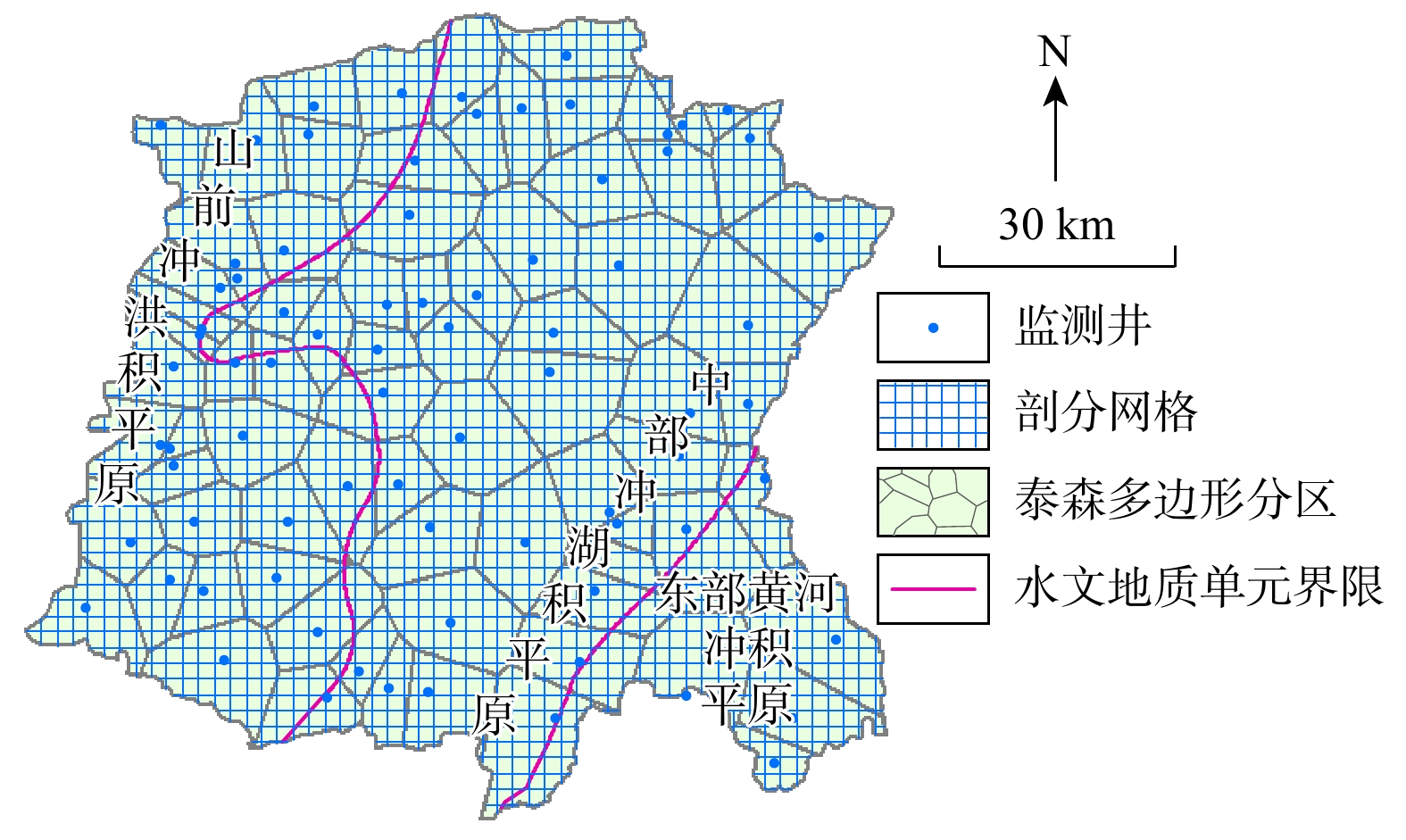
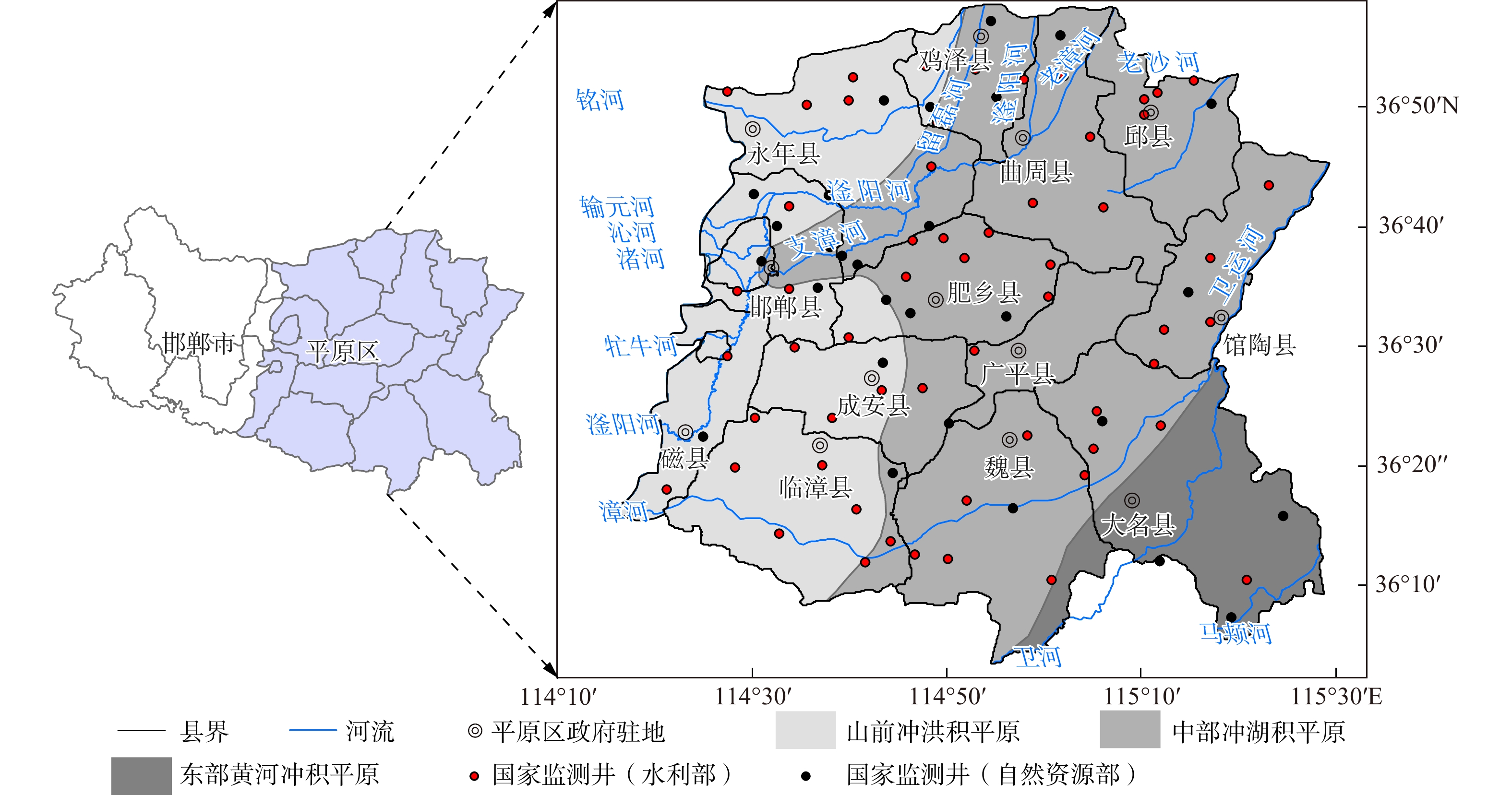
为了探究不同时间尺度水位(时刻及日、月、年平均)对区域浅层地下水储变量计算精度的影响,以2019年邯郸平原浅层地下水为研究对象,采用网格法和泰森多边形法分别计算各时间尺度下的地下水储变量,并进行对比分析。结果表明:相同时间尺度水位下,2种方法计算结果较为接近,最大差异为0.114亿m3。对于不同时间尺度水位,月平均水位与时刻水位(理论上计算精度更高)计算结果偏离程度最大,网格法与泰森多边形法分别相差0.727亿m3和0.611亿m3,偏离程度呈随机性;年平均水位与时刻水位计算结果差距较小(0.015亿m3),但接近程度也呈随机性。对于网格法,年平均水位计算结果受网格尺度影响不大(最大相差0.011亿m3);非年尺度下,计算精度随网格细化而提升。当网格分辨率优于1 km时,网格法计算精度高于泰森多边形法;但当规则剖分网格尺度接近于泰森多边形平均分区面积时,泰森多边形法计算精度更高。研究结果可为合理选用不同时间尺度水位数据,提高地下水储变量计算精度,科学评估地下水超采治理效果提供方法支撑。
Abstract:ObjectiveThis study aims to examine the influence of groundwater level at different temporal scales (specifically hourly, daily, monthly, and annual average water levels) on the accuracy of annual shallow groundwater storage variation calculations.
MethodsThe shallow groundwater system of the Handan Plain in 2019 was selected as the study object. The grid method and the Thiessen polygon method were applied to calculate groundwater storage variations using water level data at different temporal scales, and the results were compared to evaluate differences in calculation accuracy.
ResultsThe results indicated that, for the same temporal scale, groundwater storage variation estimates obtained using the grid method and the Thiessen polygon method were generally consistent, with a maximum difference of
0.0114 billion m3. At different temporal scales, both methods showed that the results calculated using monthly average water levels deviated the most from those calculated using hourly water levels, which were considered more accurate in theory. The deviations were0.0727 billion m3 for the grid method and0.0611 billion m3 for the Thiessen polygon method, with no consistent directional bias. In contrast, estimates using annual average water levels exhibited relatively small discrepancies compared to those calculated using hourly water levels, with a difference of0.0015 billion m3. However, the degree of agreement also exhibited randomness. For the grid method, the estimated results based on annual average water levels did not change significantly with grid size, with a maximum difference of0.0011 billion m3. At non-annual temporal scales, calculation accuracy improved as the grid resolution became finer. The grid method yielded more accurate results than the Thiessen polygon method when the grid resolution was finer than 1 km. However, the Thiessen polygon method demonstrated superior accuracy when the grid cell size of regular partition approached the average area of Thiessen polygons.ConclusionThese findings provide theoretical and methodological support for the rational selection of water level data at different temporal scales, thereby improving the accuracy of groundwater storage variation calculations, which is essential for evaluating the effectiveness of groundwater overexploitation control strategies.
-
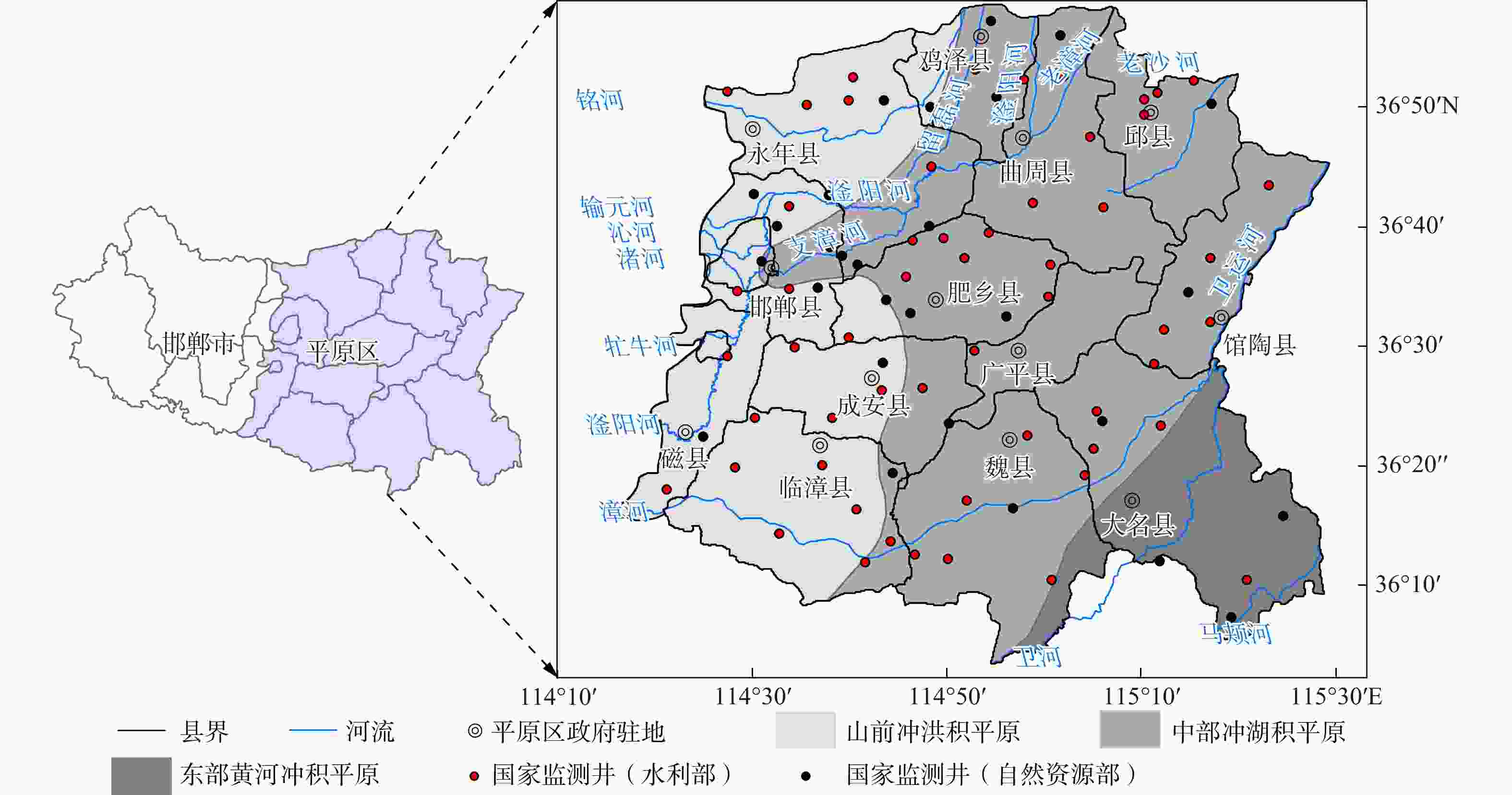
图 1 研究区位置及浅层地下水监测井分布图
注:审图号:GS(2019)1835号(自然资源部监制);底图未做改动
Figure 1. Location of study area and distribution of shallow groundwater monitoring wells
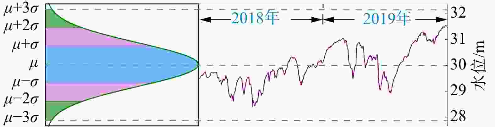
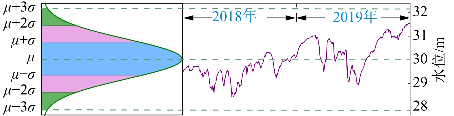
图 3 研究区监测井水位数据异常检测图
Figure 3. Anomaly detection of water level data of monitoring well
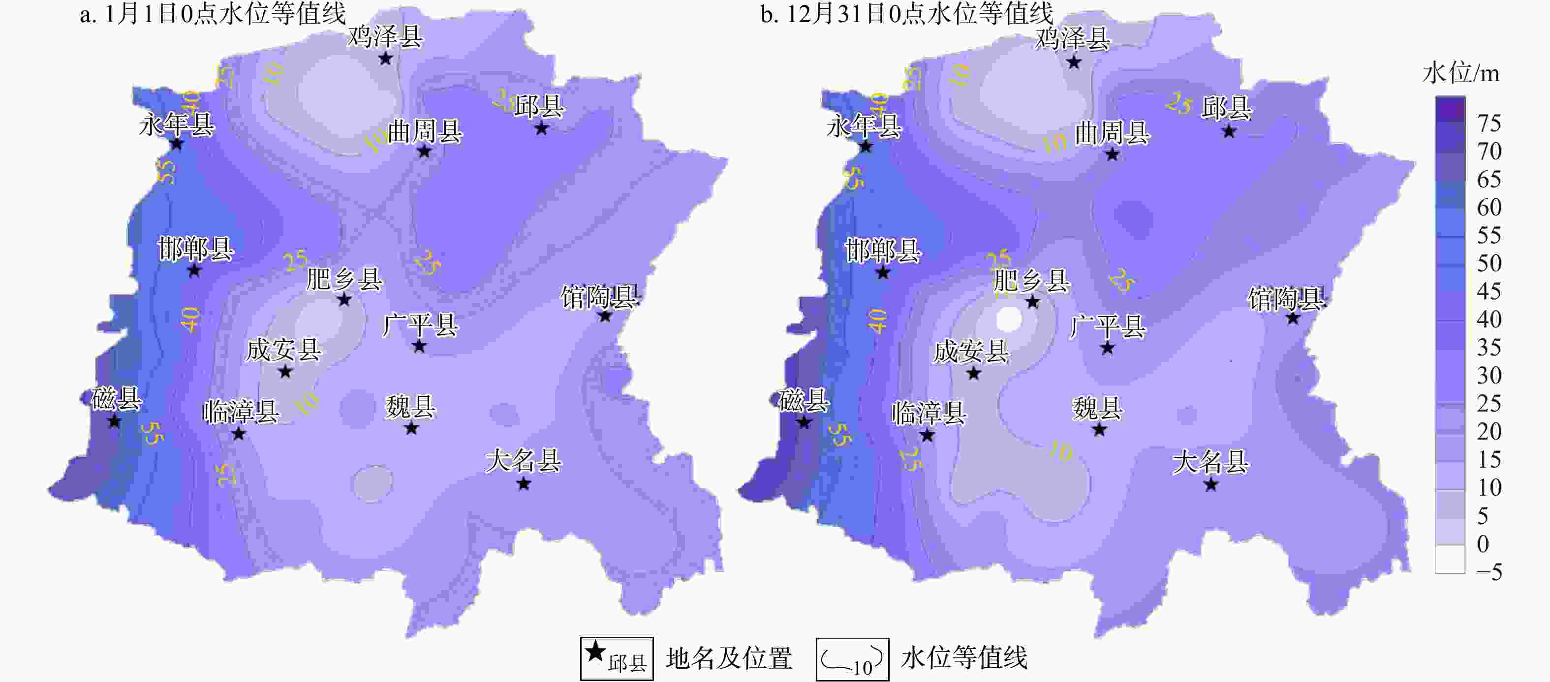
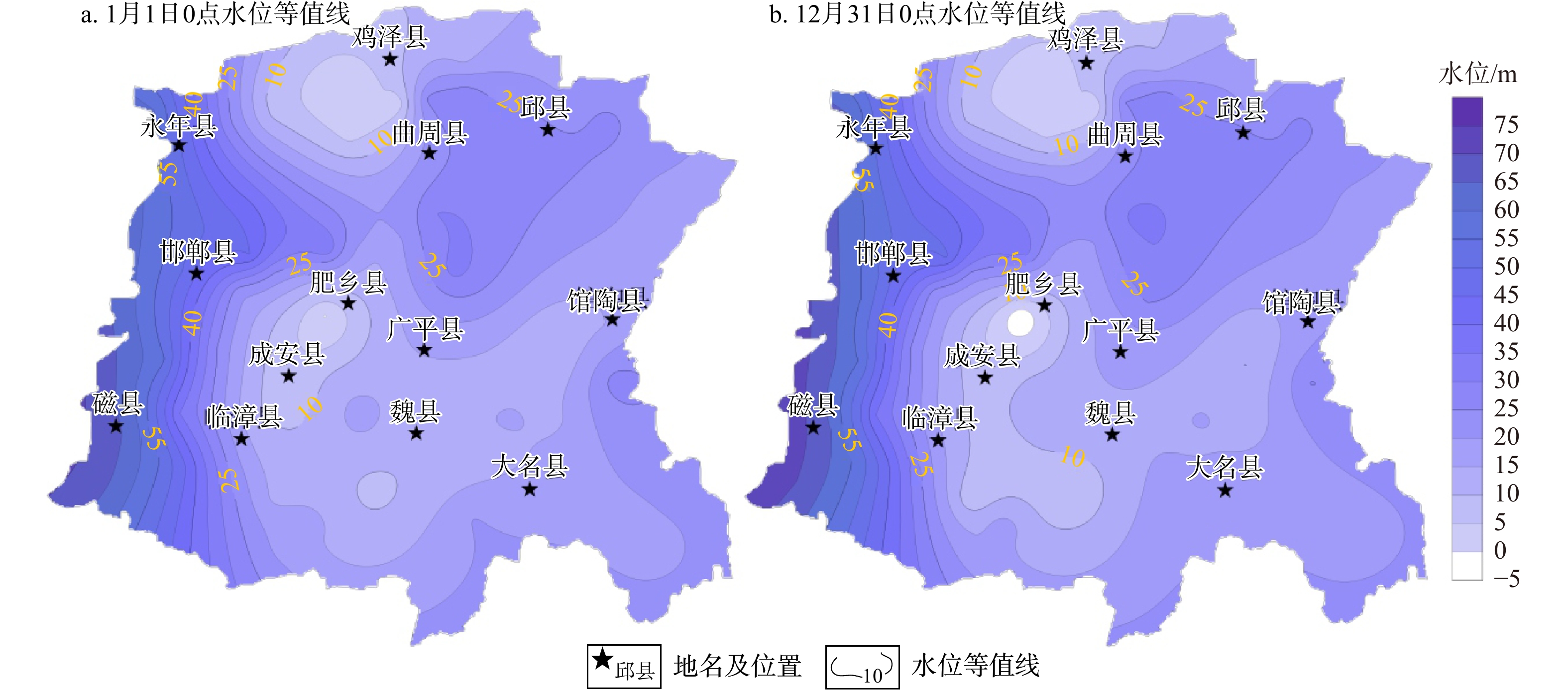
图 4 2019年邯郸平原区年初年末时刻水位等值线图
Figure 4. Contour maps of hourly water levels at beginning and end of 2019 in Handan Plain
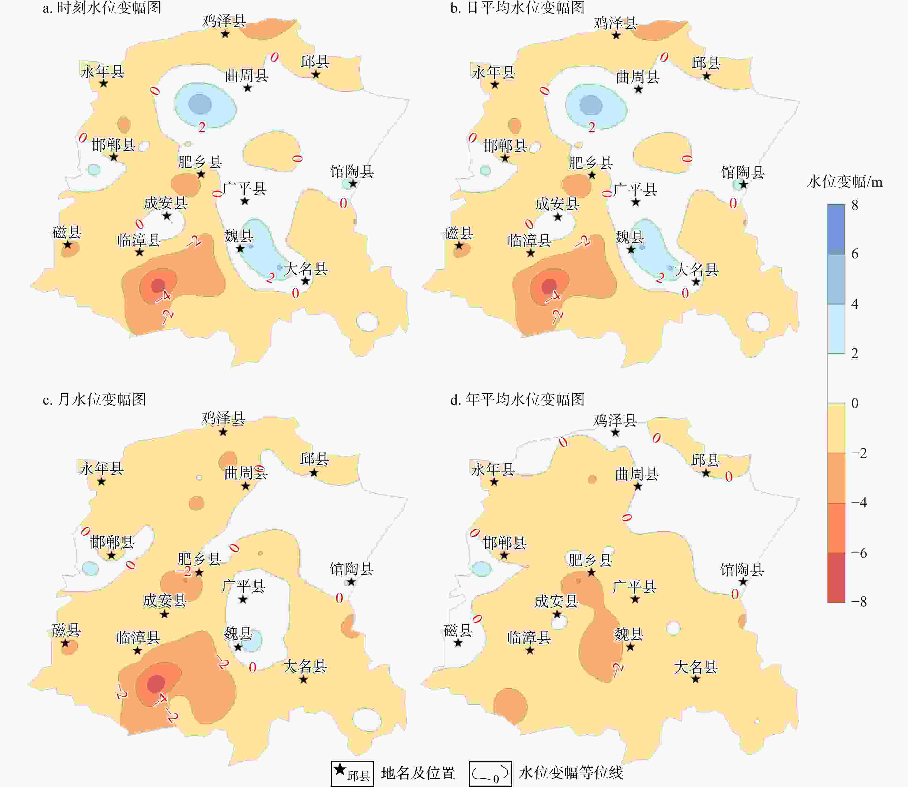
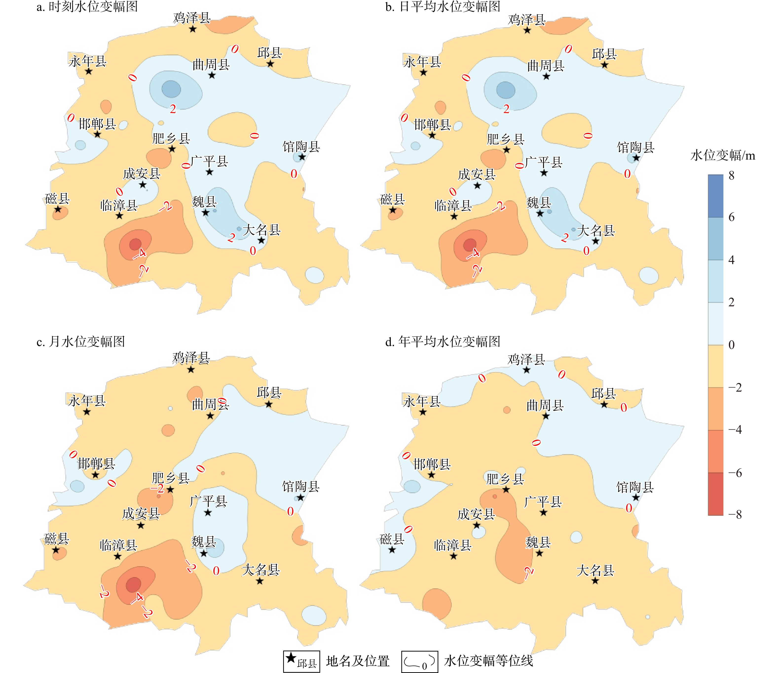
图 5 2019年邯郸平原区年初年末水位变幅等值线图
Figure 5. Contour maps of water level variation at beginning and end of 2019 in Handan Plain
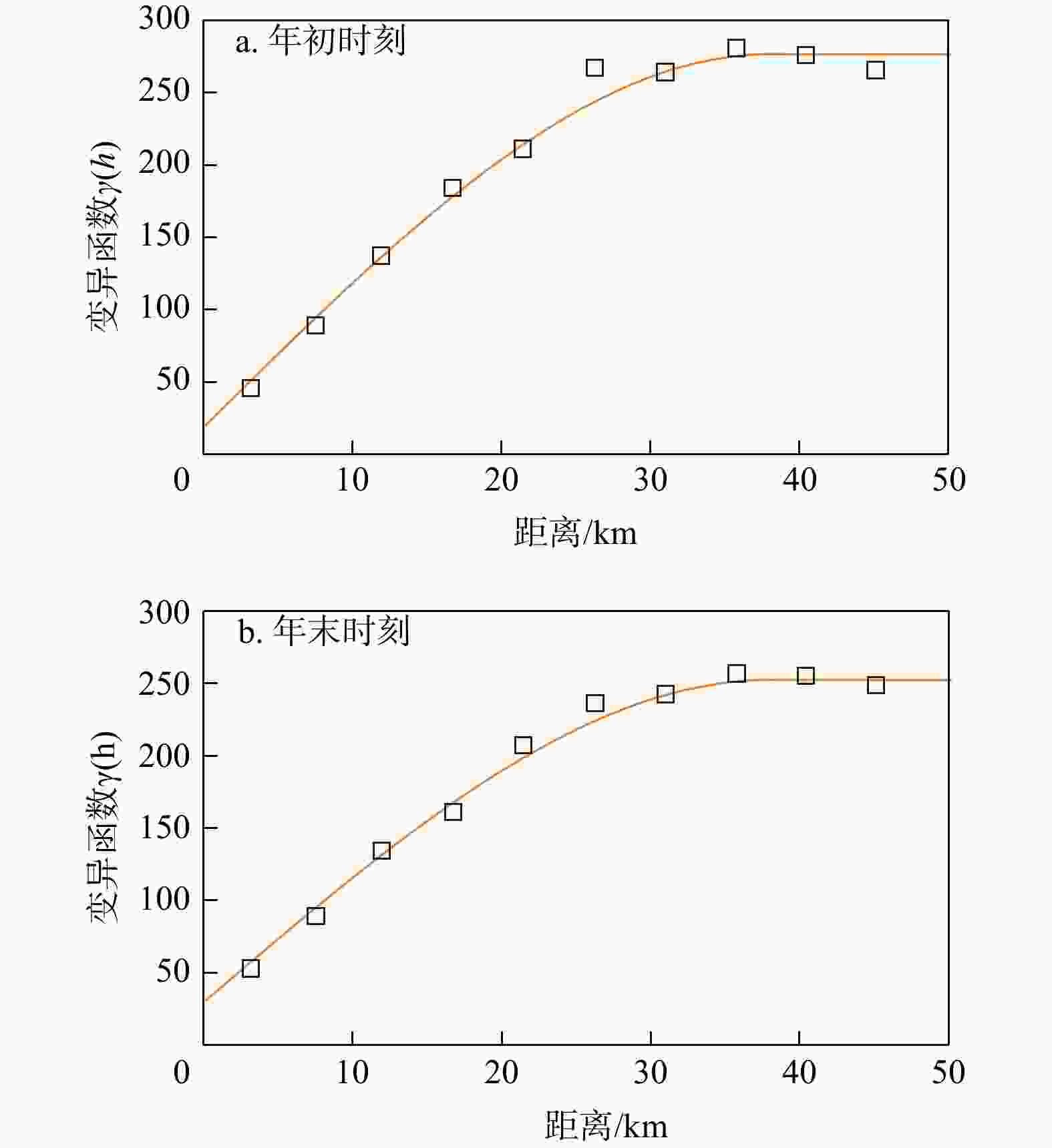
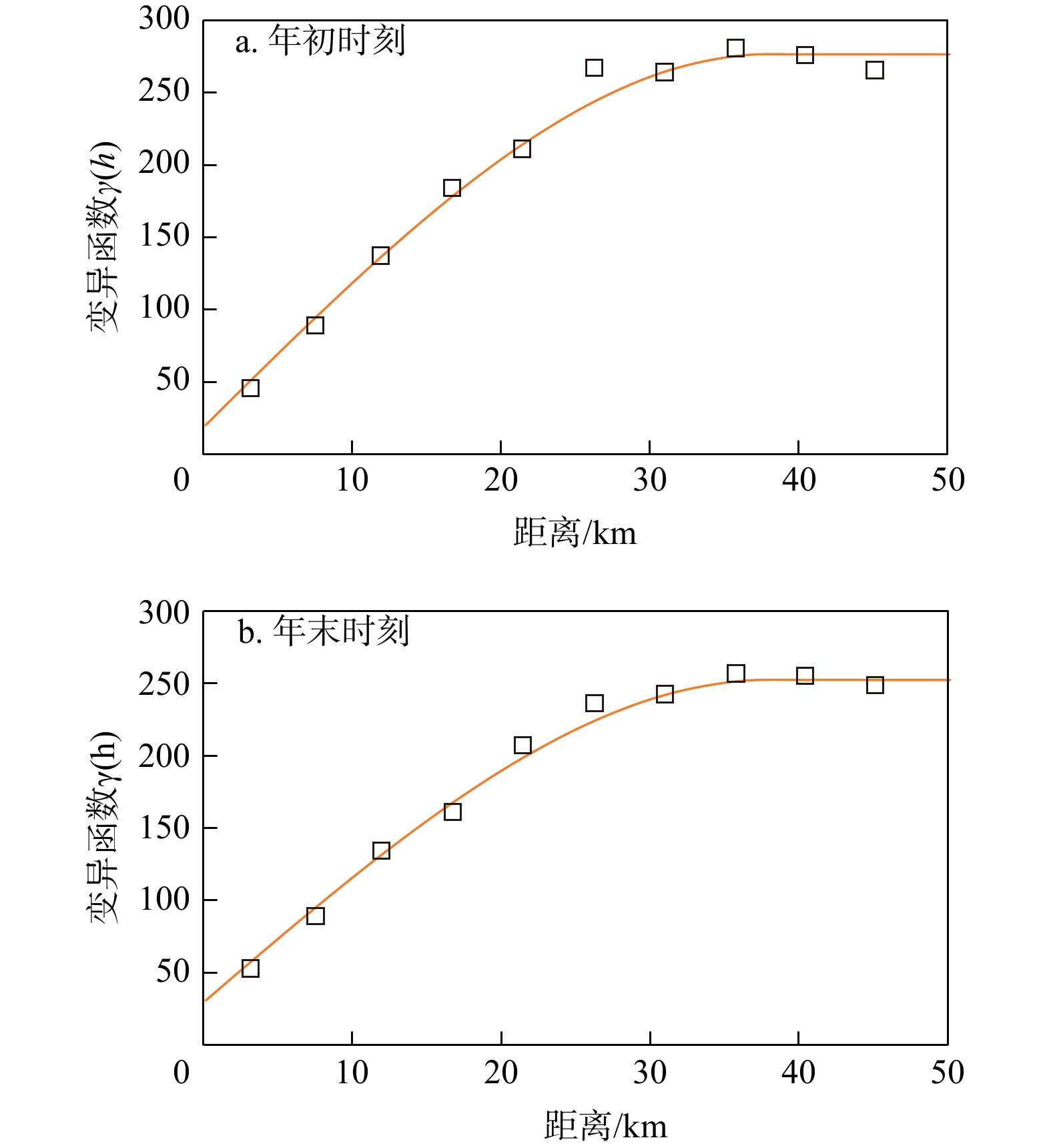
图 6 年初和年末时刻水位变异函数图
Figure 6. Variogram plots of hourly water levels at beginning and end of year
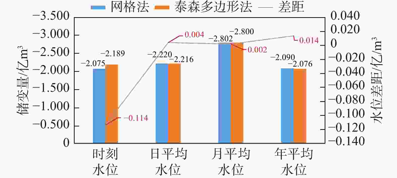
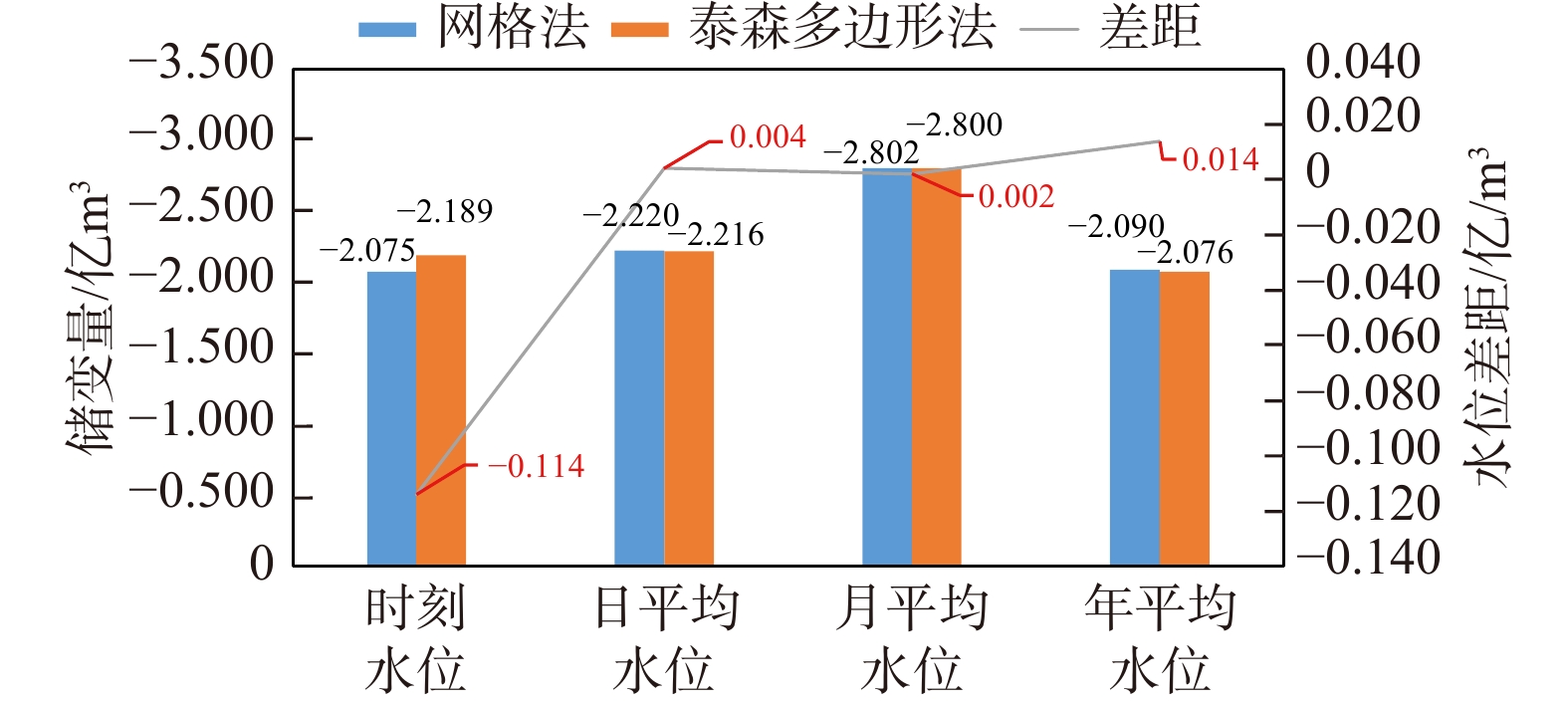
图 7 2种方法不同时间尺度水位计算储变量对比
Figure 7. Comparison of groundwater storage variations calculated by two methods with water levels at different temporal scales
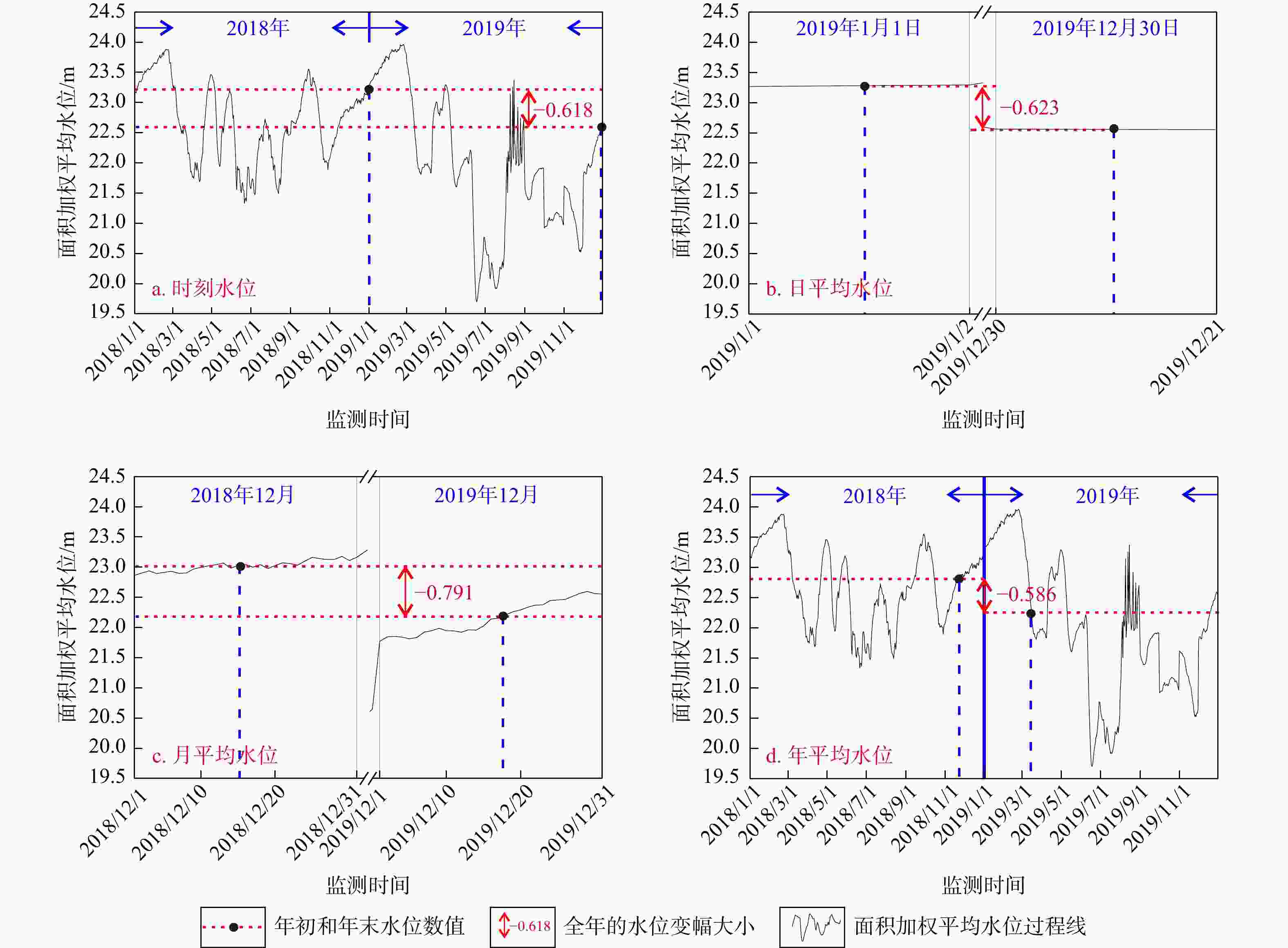
图 8 研究区不同时间尺度水位数据利用泰森多边形法计算水位变幅图示
Figure 8. Diagrams of water level variation calculated using Thiessen polygon method with water level data at different temporal scales in the study area
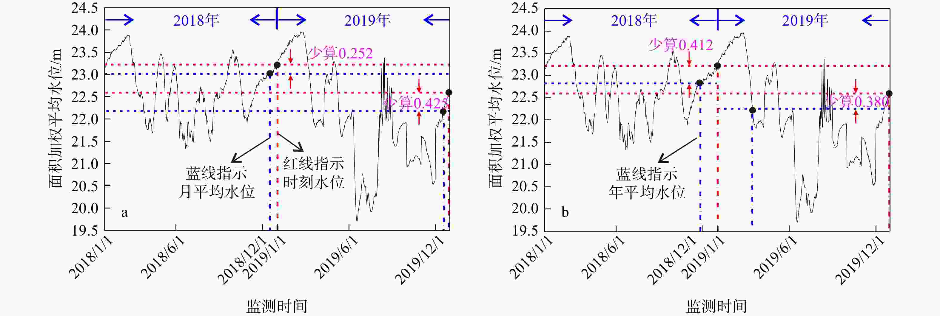
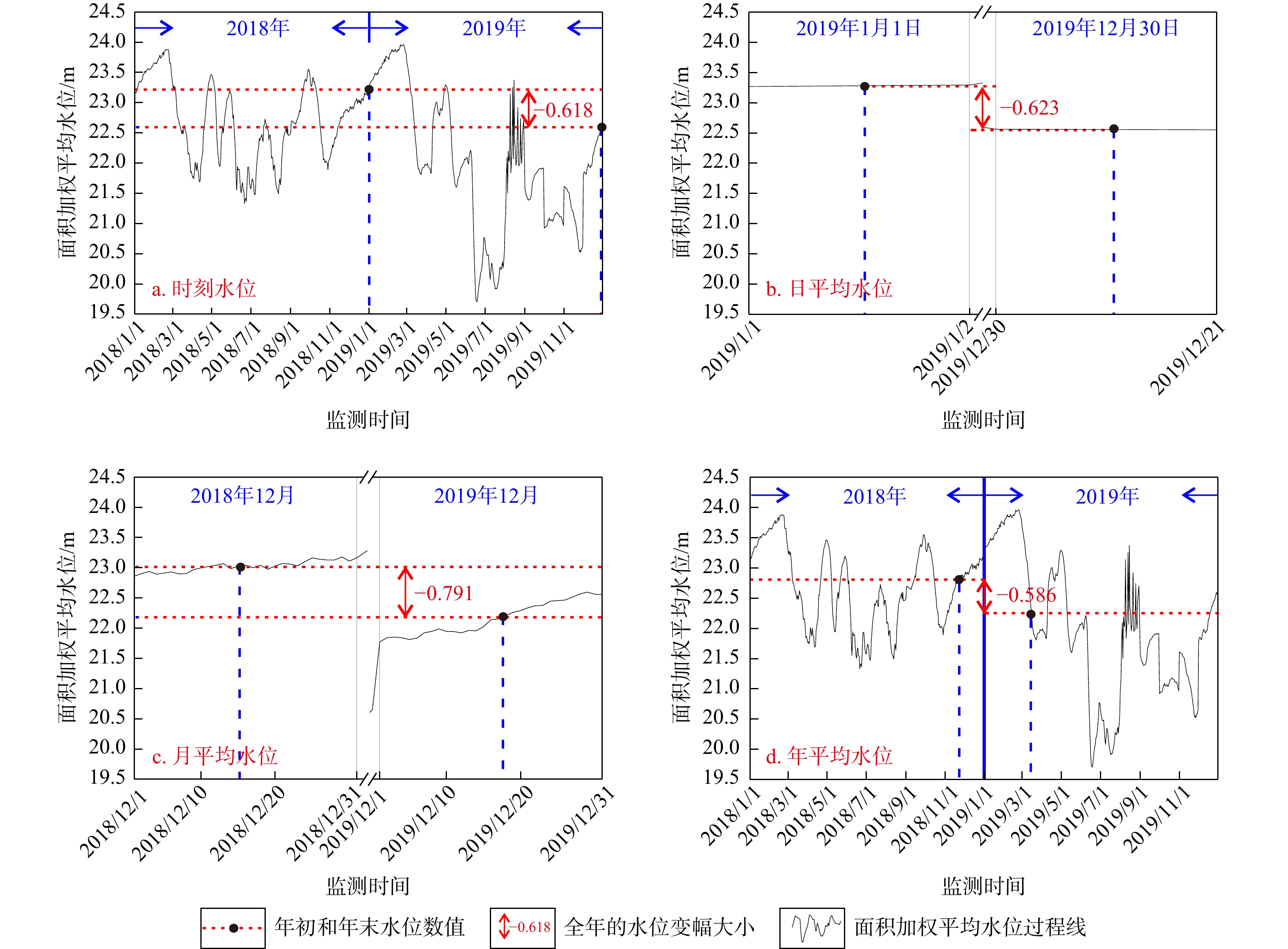
图 9 研究区月、年平均水位与时刻水位计算储变量对比
注:a,b图分别为月、年平均水位与时刻水位计算储变量对比图。蓝线交点表示2类数据计算的年初和年末平均水位在水位过程线上的位置;红线交点表示年初和年末时刻水位在过程线上的位置;红色箭头表示2种水位在年初和年末的差距
Figure 9. Comparison of groundwater storage variation calculated using monthly and annual average water levels and hourly water levels in the study area
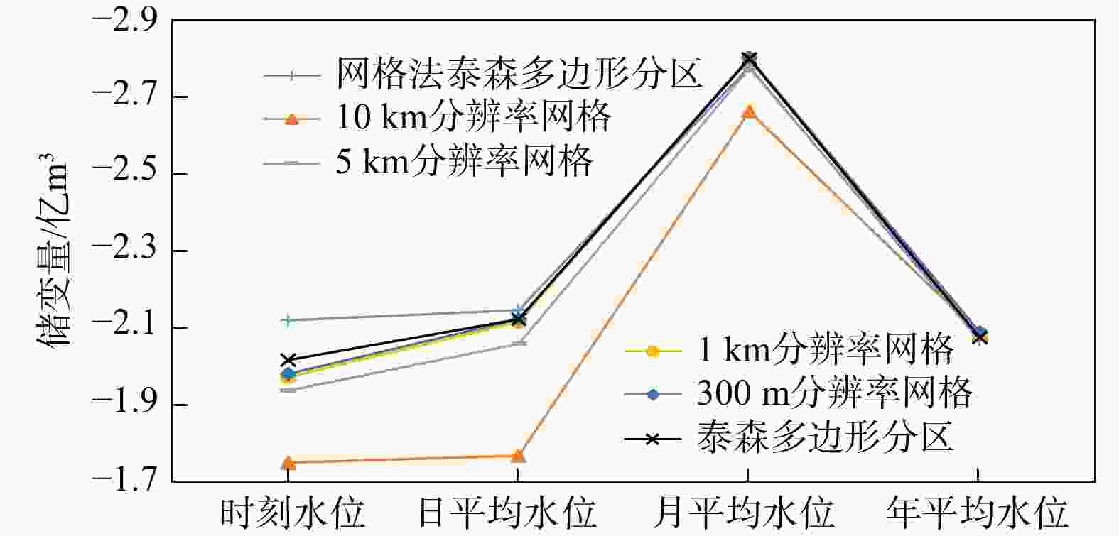
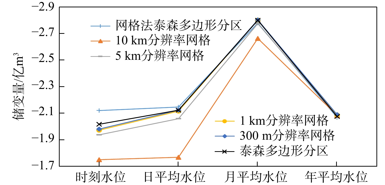
图 10 研究区不同空间尺度网格和不同时间尺度水位下2种方法计算储变量差异对比
Figure 10. Comparison of differences in groundwater storage variation calculated by two methods under different grid sizes and water levels at different temporal scales in the study area
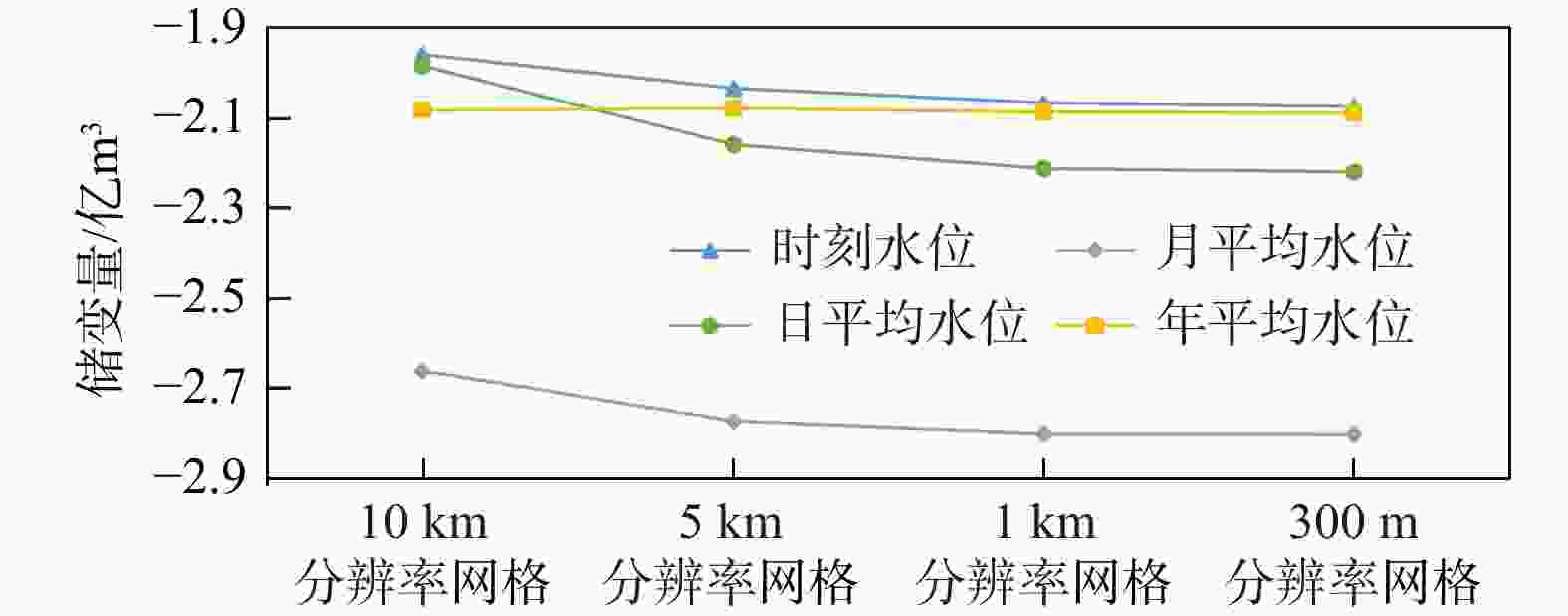
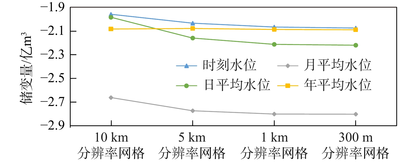
图 11 研究区同一时间尺度水位不同尺度网格计算储变量差异对比
Figure 11. Comparison of differences in groundwater storage variation calculated using different grid sizes at same temporal scale in the study area
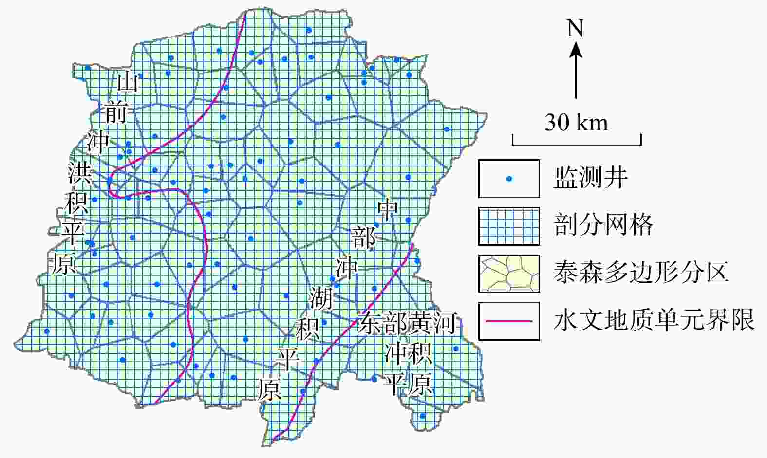
图 12 网格法与泰森多边形法剖分单元对比示意图
Figure 12. Schematic diagram of partition units in grid method and Thiessen polygon method
表 1 变异函数模型评价参数
Table 1. Evaluation parameters of variogram model
水位 变程/km 块金/m2 基台/m2 块金系数 平均误差/m 年初时刻 37.73 23.29 260.54 8.94% −0.063 年末时刻 38.12 28.77 248.21 11.59% −0.134 年初日平均 34.53 24.92 247.36 10.07% −0.063 年末日平均 38.62 26.43 247.69 10.67% −0.143 年初月平均 34.85 24.89 242.58 10.26% −0.088 年末月平均 32.18 25.52 261.84 9.75% −0.106 年初年平均 36.53 31.83 271.73 11.71% −0.138 年末年平均 33.17 33.58 282.32 11.89% −0.121  下载: 导出CSV
表 2 研究区2019年不同时间尺度水位数据采用泰森多边形法计算的储变量对比
Table 2. Comparison of groundwater storage variation calculated using Thiessen polygon method with water level data at different temporal scales of 2019 in the study area
不同水位数据 加权平均水位/m 储变量/亿m3 年初 年末 水位变幅 时刻水位 23.270 22.652 −0.618 −2.189 日平均水位 23.280 22.657 −0.623 −2.216 月平均水位 23.018 22.227 −0.791 −2.800 年平均水位 22.858 22.272 −0.586 −2.076
下载: 导出CSV
表 3 2种方法其他尺度水位与时刻水位计算的储变量差异对比
Table 3. Comparison of differences in groundwater storage variation calculated by two methods with water levels at other temporal scales and hourly water levels
A−A/亿m3 B−A/亿m3 C−A/亿m3 D−A/亿m3 网格法
泰森多边形法0 −0.145 −0.727 −0.015 0 −0.027 −0.611 0.113 注:时刻水位计算的储变量记作A,日平均记作B,月平均记作C,年平均记作D;B−A表示日平均水位计算的储变量减去时刻水位计算的储变量
下载: 导出CSV
表 4 研究区单位面积储变量差异对比
Table 4. Comparison of differences in groundwater storage variation per unit area in the study area
方法 单位面积储变量/(万m3·km−2) 与时刻水位差距/(万m3·km−2) 网格法 泰森多边形法 差距 网格法 泰森多边形法 时刻水位 −2.762 −2.931 −0.169 0.000 0.000 日平均水位 −2.954 −2.949 0.005 −0.193 −0.018 月平均水位 −3.729 −3.726 0.003 −0.968 −0.795 年平均水位 −2.781 −2.763 0.018 −0.020 0.168
下载: 导出CSV
表 5 多种情况下2种方法计算的储变量结果
Table 5. Groundwater storage variation calculated by two methods under multiple conditions
方法 网格尺寸 储变量/亿m3 时刻水位 日平均水位 月平均水位 年平均水位 网格法 泰森多边形分区 −2.215 −2.245 −2.779 −2.068 10 km×10 km −1.959 −1.984 −2.662 −2.083 5 km×5 km −2.034 −2.159 −2.773 −2.079 1 km×1 km −2.066 −2.213 −2.801 −2.087 300 m×300 m −2.075 −2.220 −2.802 −2.090 泰森
多边形法泰森多边形分区 −2.189 −2.216 −2.800 −2.076
下载: 导出CSV
-
[1] 杨会峰, 曹文庚, 支传顺, 等. 近40年来华北平原地下水位演变研究及其超采治理建议[J]. 中国地质, 2021, 48(4): 1142-1155. doi: 10.12029/gc20210411YANG H F, CAO W G, ZHI C S, et al. Evolution of groundwater level in the North China Plain in the past 40 years and suggestions on its overexploitation treatment[J]. Geology in China, 2021, 48(4): 1142-1155. (in Chinese with English abstract doi: 10.12029/gc20210411 [2] 李文鹏, 王龙凤, 杨会峰, 等. 华北平原地下水超采状况与治理对策建议[J]. 中国水利, 2020(13): 26-30. doi: 10.3969/j.issn.1000-1123.2020.13.017LI W P, WANG L F, YANG H F, et al. The groundwater overexploitation status and countermeasure suggestions of the North China Plain[J]. China Water Resources, 2020(13): 26-30. (in Chinese with English abstract doi: 10.3969/j.issn.1000-1123.2020.13.017 [3] 左世诚, 董杰, 廖明生. 时序InSAR形变梯度估计与城市建筑物风险评估: 以北京平原为例[J]. 地质科技通报, 2024, 43(6): 171-183.ZUO S C, DONG J, LIAO M S. Time-series InSAR deformation gradient estimation and urban buildings risk assessment: A case study in the Beijing Plain[J]. Bulletin of Geological Science and Technology, 2024, 43(6): 171-183. (in Chinese with English abstract [4] 于翔, 解建仓, 姜仁贵, 等. 河北省地下水超采治理效果过程化评价[J]. 排灌机械工程学报, 2021, 39(4): 364-371. doi: 10.3969/j.issn.1674-8530.20.0145YU X, XIE J C, JIANG R G, et al. Process evaluation for governance effect of groundwater over-exploitation in Hebei Province[J]. Journal of Drainage and Irrigation Machinery Engineering, 2021, 39(4): 364-371. (in Chinese with English abstract doi: 10.3969/j.issn.1674-8530.20.0145 [5] KINZELBACH W, WANG H J, LI Y, et al. Groundwater overexploitation in the North China Plain: A path to sustainability[M]. Singapore: Springer Singapore, 2022. [6] 冯战洪, 苏建平. 多措并举推进河北地下水超采治理[J]. 中国水利, 2022(6): 15-16.FENG Z H, SU J P. Control of groundwater over-exploitation in Hebei with multiple measures[J]. China Water Resources, 2022(6): 15-16. (in Chinese with English abstract [7] LI H Y, DU X Q, LU X Q, et al. Analysis of groundwater overexploitation based on groundwater regime information[J]. Groundwater, 2023, 61(5): 692-705. doi: 10.1111/gwat.13285 [8] YANG H F, MENG R F, BAO X L, et al. Assessment of water level threshold for groundwater restoration and over-exploitation remediation in the Beijing-Tianjin-Hebei plain[J]. Journal of Groundwater Science and Engineering, 2022, 10(2): 113-127. [9] 羊艳, 唐世南, 于丽丽. 地下水超采综合治理与修复模式研究[J]. 水利规划与设计, 2021(12): 92-96.YANG Y, TANG S N, YU L L. Study on comprehensive treatment and restoration model of groundwater overexploitation[J]. Water Resources Planning and Design, 2021(12): 92-96. (in Chinese with English abstract [10] SUN L, WANG X Y, WANG S W, et al. Experimental study on soil deformation caused by overexploitation of groundwater[J]. Water Environment Research, 2024, 96(9): e11111. doi: 10.1002/wer.11111 [11] GE Y X, WU J, LI B H, et al. Analysis and evaluation of variation characteristics in groundwater resources carrying capacity in Beijing between 2010 and 2020[J]. Sustainability, 2022, 14(15): 9200. doi: 10.3390/su14159200 [12] LIU X M, LIU C M, BRUTSAERT W. Mutual consistency of groundwater storage changes derived from GRACE and from baseflow recessions in the Central Yangtze River Basin[J]. Journal of Geophysical Research: Atmospheres, 2020, 125(24): e2019JD031467. doi: 10.1029/2019jd031467 [13] 魏士禹, 郭云彤, 崔亚莉, 等. 1985—2016年民勤地下水位及储变量动态特征分析[J]. 干旱区地理, 2021, 44(5): 1272-1280.WEI S Y, GUO Y T, CUI Y L, et al. Dynamic characteristics of groundwater level and storage variables in Minqin from 1985 to 2016[J]. Arid Land Geography, 2021, 44(5): 1272-1280. (in Chinese with English abstract [14] 张庆卜. 国家级地下水位监测数据分析研究[D]. 北京: 中国地质大学(北京), 2020: 35-68.ZHANG Q B. Analysis and research on monitoring data of national groundwater level[D]. Beijing: China University of Geosciences (Beijing), 2020: 35-68. (in Chinese with English abstract [15] 韩志国. 地下水蓄变量计算方法的探讨[J]. 治淮, 2008(11): 21-22. doi: 10.3969/j.issn.1001-9243.2008.11.013HAN Z G. Discussion on methods for calculating groundwater storage changes[J]. Harnessing the Huaihe River, 2008(11): 21-22. (in Chinese with English abstract doi: 10.3969/j.issn.1001-9243.2008.11.013 [16] 孟春丽, 王闯, 魏雅琴. 2013年中牟县地下水动态及水量平衡分析[J]. 河南水利与南水北调, 2014, 43(14): 9-10.MENG C L, WANG C, WEI Y Q. Analysis of Groundwater Dynamics and Water Balance in Zhongmu County in 2013[J]. Water Resources & South to North Water Diversion, 2014, 43(14): 9-10. (in Chinese with English abstract [17] JI Z J, CUI Y L, ZHANG S Q, et al. Evaluation of the impact of ecological water supplement on groundwater restoration based on numerical simulation: A case study in the section of Yongding River, Beijing Plain[J]. Water, 2021, 13(21): 3059. doi: 10.3390/w13213059 [18] 党婧萱, 田涛, 李闯, 等. 基于机器学习与多源数据融合的江苏省潜水位空间分布估计[J]. 地质科技通报, 2026, 45(2): 351-360.DANG J X, TIAN T, LI C, et al. Exploration of groundwater table spatial estimation in Jiangsu Province based on machine learning and multi-source data fusion[J]. Bulletin of Geological Science and Technology, 2026, 45(2): 351-360. (in Chinese with English abstract [19] SCANLON B R, FAKHREDDINE S, RATEB A, et al. Global water resources and the role of groundwater in a resilient water future[J]. Nature Reviews Earth & Environment, 2023, 4(2): 87-101. doi: 10.1038/s43017-022-00378-6 [20] YIN W J, HAN S C, ZHENG W, et al. Improved water storage estimates within the North China Plain by assimilating GRACE data into the CABLE model[J]. Journal of Hydrology, 2020, 590: 125348. doi: 10.1016/j.jhydrol.2020.125348 [21] 刘东旭, 胡立堂, 孙建冲, 等. 基于GRACE/GRACE-FO数据降尺度方法反演库尔勒东区地下水储量变化[J]. 测绘学报, 2024, 53(7): 1265-1277. doi: 10.11947/j.AGCS.2024.20230354LIU D X, HU L T, SUN J C, et al. Retrieval of groundwater storage anomalies in eastern region of Korla by downscaling GRACE/GRACE-FO data[J]. Acta Geodaetica et Cartographica Sinica, 2024, 53(7): 1265-1277. (in Chinese with English abstract doi: 10.11947/j.AGCS.2024.20230354 [22] LEMON M G, KEIM R F. Hydrological controls and sources of water for shallow groundwater of underfit, fine-grained floodplains[J]. Hydrological Processes, 2025, 39(2): e70094. doi: 10.1002/hyp.70094 [23] ALI S, LIU D, FU Q, et al. Improving the resolution of GRACE data for spatio-temporal groundwater storage assessment[J]. Remote Sensing, 2021, 13(17): 3513. doi: 10.3390/rs13173513 [24] 章树安, 孙龙, 杨桂莲. 关于提升国家地下水监测体系和综合分析能力的研究与思考[J]. 中国水利, 2021(7): 9-12.ZHANG S A, SUN L, YANG G L. Research and reflections on enhancing the national groundwater monitoring system and comprehensive analysis capability[J]. China Water Resources, 2021(7): 9-12. (in Chinese with English abstract [25] 杨泽森, 林晶晶, 常启昕, 等. 地下水与湖泊交互作用的研究趋势与前沿[J]. 地质科技通报, 2024, 43(6): 306-317.YANG Z S, LIN J J, CHANG Q X, et al. Research trends and frontiers of groundwater-lake interaction[J]. Bulletin of Geological Science and Technology, 2024, 43(6): 306-317. (in Chinese with English abstract [26] 袁有靖, 彭红明, 肖勇, 等. 湟水河流域引胜沟地下水流数值模拟及地下水资源应急保障能力研究[J]. 盐湖研究, 2025, 33(1): 48-56. doi: 10.3724/j.yhyj.2024050YUAN Y J, PENG H M, XIAO Y, et al. Numerical simulation of groundwater flow and evaluation of groundwater resources emergency exploitation capacity in Yinsheng gully of Huangshui River watershed[J]. Journal of Salt Lake Research, 2025, 33(1): 48-56. (in Chinese with English abstract doi: 10.3724/j.yhyj.2024050 [27] 郭晓东, 刘强, 李文鹏, 等. 西辽河平原地下水失衡及其与土地利用的互馈关系[J]. 水文地质工程地质, 2024, 51(4): 77-87.GUO X D, LIU Q, LI W P, et al. Groundwater imbalance and its mutual feedback relationship with land use in West Liaohe Plain[J]. Hydrogeology and Engineering Geology, 2024, 51(4): 77-87. (in Chinese with English abstract [28] 吴志豪, 高燕燕, 温芮, 等. 秦岭北麓沣河流域地下水−地表水化学特征及转化关系[J]. 地球科学与环境学报, 2024, 46(3): 334-350. doi: 10.19814/j.jese.2024.02009WU Z H, GAO Y Y, WEN R, et al. Chemical characteristics and transformation relationship of groundwater and surface water in Fenghe River basin at the northern foot of Qinling Mountains, China[J]. Journal of Earch Sciences and Environment, 2024, 46(3): 334-350. (in Chinese with English abstract doi: 10.19814/j.jese.2024.02009 [29] 张士杰, 黄智华. 华北平原邯郸地区地下水位动态及成因分析[J]. 人民黄河, 2019, 41(增刊2): 25-27.ZHANG S J, HUANG Z H. Analysis of groundwater level dynamics and causes in the Handan area of the North China Plain[J]. Yellow River, 2019, 41(S2): 25-27. (in Chinese with English abstract [30] 周伟凯. 邯郸平原区地下水动态模拟研究[D]. 河北邯郸: 河北工程大学, 2017: 32-60.ZHOU W K. Dynamic simulation of groundwater in Handan Plain area[D]. Handan Hebei: Hebei University of Engineering, 2017: 32-60. (in Chinese with English abstract [31] 孙健. 基于MODFLOW的邯郸市东部平原区地下水数值模拟研究[D]. 北京: 中国地质大学(北京), 2017: 40-50.SUN J. Numerical simulation study of groundwater in eastern plain area of Handan based on MODFLOW[D]. Beijing: China University of Geosciences, 2017: 40-50. (in Chinese with English abstract [32] 刘岩, 李鹏, 李莎, 等. 浅析邯郸市东部平原区浅层地下水动态规律及变化趋势预测[J]. 地下水, 2023, 45(6): 72-74.LIU Y, LI P, LI S, et al. Analyzing the dynamic pattern of shallow groundwater and predicting the trend of changes in the eastern plain area of Handan city[J]. Ground Water, 2023, 45(6): 72-74. (in Chinese with English abstract [33] 白林, 李振洪, 宋莎, 等. 利用时序InSAR技术反演邯郸平原区地表形变与含水层参数[J]. 地球物理学报, 2022, 65(9): 3351-3362.BAI L, LI Z H, SONG S, et al. Estimation of the land deformation and aquifer parameters in the Handan Plain using multi-temporal InSAR technology[J]. Chinese Journal of Geophysics, 2022, 65(9): 3351-3362. (in Chinese with English abstract [34] YANG S, MA Y L, DUAN F K, et al. Characteristics and formation of typical winter haze in Handan, one of the most polluted cities in China[J]. Science of the Total Environment, 2018, 613/614: 1367-1375. [35] HAO H D, ZHANG M M, WANG J X, et al. Distribution pattern and enrichment mechanism of selenium in topsoil in Handan Se-enriched belt, North China[J]. Sustainability, 2022, 14(6): 3183. doi: 10.3390/su14063183 [36] HUSSAIN R, WEI C H, LUO K L. Hydrogeochemical characteristics, source identification and health risks of surface water and groundwater in mining and non-mining areas of Handan, China[J]. Environmental Earth Sciences, 2019, 78(14): 402. doi: 10.1007/s12665-019-8350-9 [37] 王鑫, 张涛, 金映谷. 异常检测算法综述[J]. 现代计算机, 2020(30): 21-26. doi: 10.11772/j.issn.1001-9081.2022060808WANG X, ZHANG T, JIN Y G. Overview of anomaly detection algorithms[J]. Modern Computer, 2020(30): 21-26. (in Chinese with English abstract doi: 10.11772/j.issn.1001-9081.2022060808 [38] PANG G S, SHEN C H, CAO L B, et al. Deep learning for anomaly detection: A review[J]. ACM Computing Surveys, 2022, 54(2): 1-38. [39] TAHA A, HADI A S. Anomaly detection methods for categorical data: A review[J]. ACM Computing Surveys, 2020, 52(2): 1-35. doi: 10.1145/3312739 [40] XU X D, LIU H W, YAO M H. Recent progress of anomaly detection[J]. Complexity, 2019, 2019(1): 2686378. doi: 10.1155/2019/2686378 [41] NANDA S K, RAY L. Quantitative application of sigma metrics in medical biochemistry[J]. Journal of Clinical and Diagnostic Research, 2013, 7(12): 2689-2691. doi: 10.7860/jcdr/2013/7292.3700 [42] 王俊霖, 黄兵, 郑颖, 等. 环洞庭湖区地下水位空间分布特征研究[J]. 长江流域资源与环境, 2020, 29(4): 919-927. doi: 10.11870/cjlyzyyhj202004013WANG J L, HUANG B, ZHENG Y, et al. Spatial characteristics of groundwater level in Dongting Lake area[J]. Resources and Environment in the Yangtze Basin, 2020, 29(4): 919-927. (in Chinese with English abstract doi: 10.11870/cjlyzyyhj202004013 [43] 李相通. 滏阳河生态补水后水生生物群落特征变化研究[D]. 河北 邯郸: 河北工程大学, 2020: 40-50.LI X T. A study on the community structure characteristics of aquatic organisms in the Fuyang River after ecological water supplement[D]. Handan Hebei: Hebei University of Engineering, 2020: 40-50. (in Chinese with English abstract -

 下载:
下载:


 点击查看大图
计量
- 文章访问数: 121
- PDF下载量: 13
- 被引次数: 0

