投审稿入口
投审稿入口


Early identification and susceptibility assessment of landslide hazards in southern Dengfeng, Henan Province
-
摘要:
河南省登封市南部地处嵩山山脉与黄河中下游平原过渡地带,地形地质条件复杂,滑坡灾害频发,对区域生产安全与居民生活构成严重威胁。开展滑坡隐患早期识别与高精度易发性评价,对区域地质灾害防治具有重要现实意义。综合运用光学遥感与小基线集合成孔径雷达干涉测量(SBAS-InSAR)技术开展滑坡隐患早期识别,选取高程、坡度、地层岩性等12项关键评价因子,基于信息量模型与机器学习方法(人工神经网络、随机森林及Stacking集成策略)进行滑坡易发性评价,并采用斜坡单元优化评价结果输出。结果表明:①通过多源遥感解译与野外验证,共识别滑坡隐患点33处,主要分布于研究区中部、西南及东南区域,空间分布与地形坡度、岩性软弱层及人类工程活动显著相关;②研究区滑坡易发性呈现北低南高分布特征,Stacking集成策略模型AUC值达0.96,预测精度最优,显著优于单一模型及传统信息量模型,8.60%的高易发区空间覆盖率即可捕获87.72%滑坡样本。本研究构建的多源遥感识别+集成学习评价技术框架,为登封南部地区滑坡风险精准防控提供了高精度数据支撑与技术范式,同时验证了集成学习在复杂地形区滑坡易发性评价中的显著优势。
-
关键词:
- 滑坡灾害 /
- 早期识别 /
- 易发性评价 /
- SBAS-InSAR /
- Stacking集成策略模型 /
- 机器学习 /
- 河南省登封市
Abstract:ObjectiveThe southern region of Dengfeng City in Henan Province lies in the transitional zone between the Songshan Mountains and the Middle and Lower reaches of the Yellow River plain. Complex topographic and geological conditions in this region lead to frequent landslide hazards, posing serious threats to regional production safety and residents' lives. Conducting early identification of landslide hazards and high-precision susceptibility assessment is practically significant for the prevention and control of regional geological hazards.
MethodsThis study applied optical remote sensing and small baseline subset interferometric synthetic aperture radar (SBAS-InSAR) for the early identification of landslide hazards. Twelve key evaluation factors, including elevation, slope, and lithology, were selected. Landslide susceptibility assessment was carried out based on the information value model and machine learning methods (artificial neural network, random forest, and stacking ensemble model). Additionally, slope units were used to optimize the output of evaluation results.
ResultsThe results showed that: (1) A total of 33 landslide hazard sites were identified through multi-source remote sensing interpretation and field verification. They were mainly distributed in the central, southwestern, and southeastern parts of the study area, and their spatial distribution was significantly correlated with terrain slope, weak lithological layers, and human engineering activities. (2) Landslide susceptibility in the study area showed a distribution pattern of lower susceptibility in the north and higher susceptibility in the south. The stacking ensemble model achieved the highest prediction accuracy with an area under the curve (AUC) value of 0.96, which was significantly better than single models and the traditional information value model. The high susceptibility zone accounted for only 8.60% of the total area but captured 87.72% of the landslide samples.
ConclusionThe technical framework of multi-source remote sensing identification combined with ensemble learning evaluation constructed in this study provides high-precision data support and a technical paradigm for accurate prevention and control of landslide risks in the southern region of Dengfeng. It also verifies the significant advantages of ensemble learning for landslide susceptibility assessment in complex terrain areas.
-
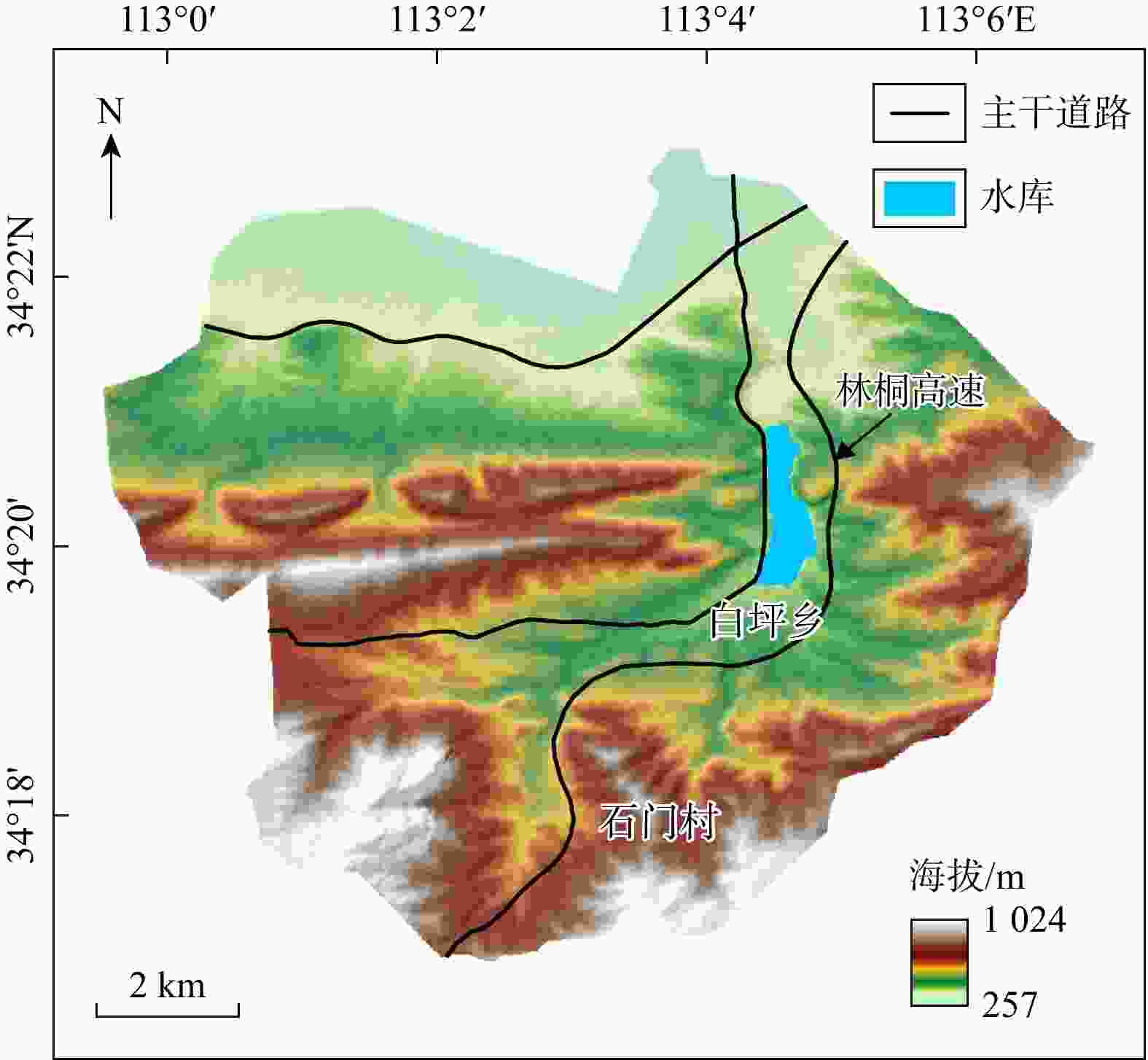
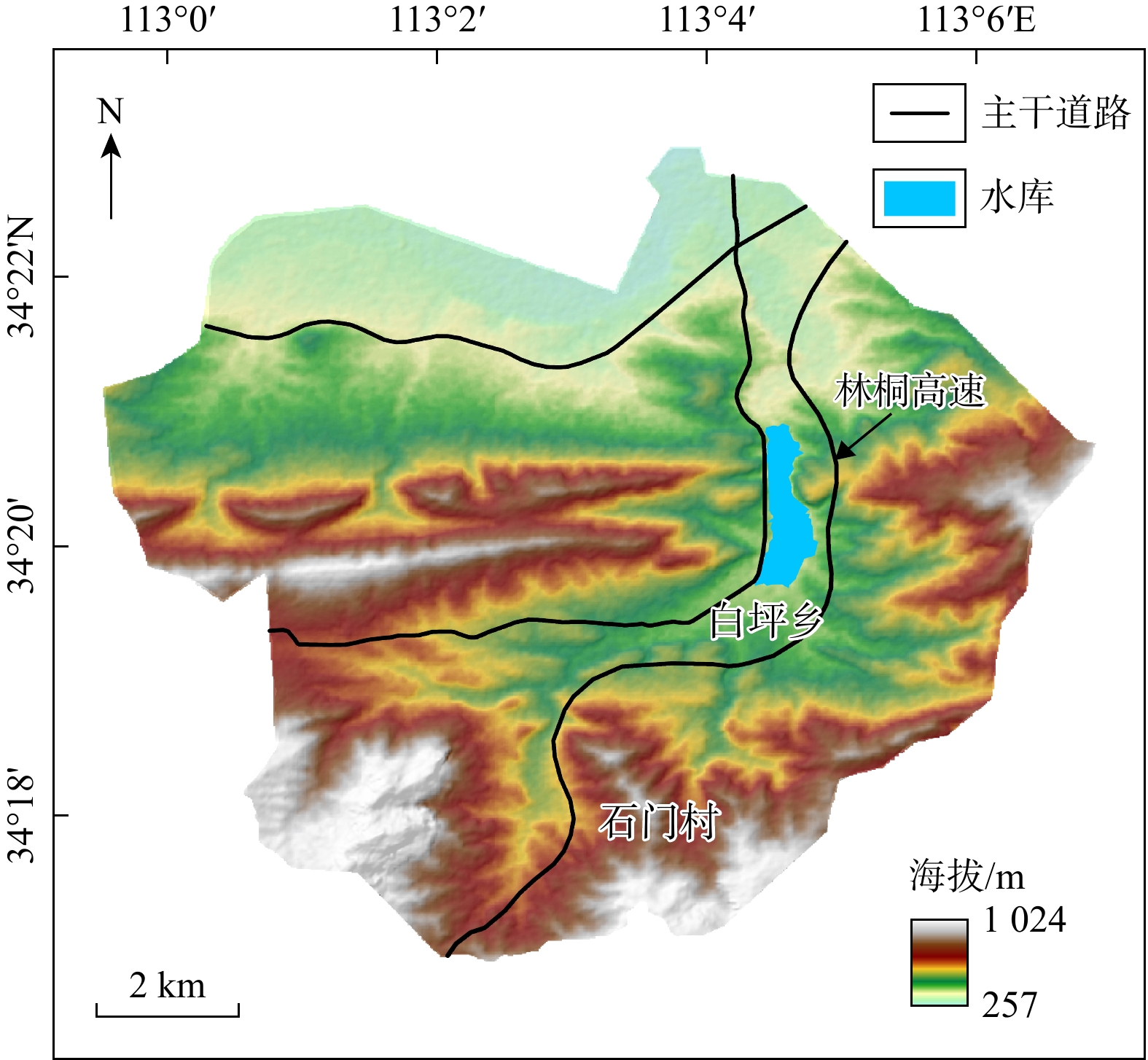
图 1 研究区地理位置及交通路线图
Figure 1. Geographical location and transportation routes in the study area
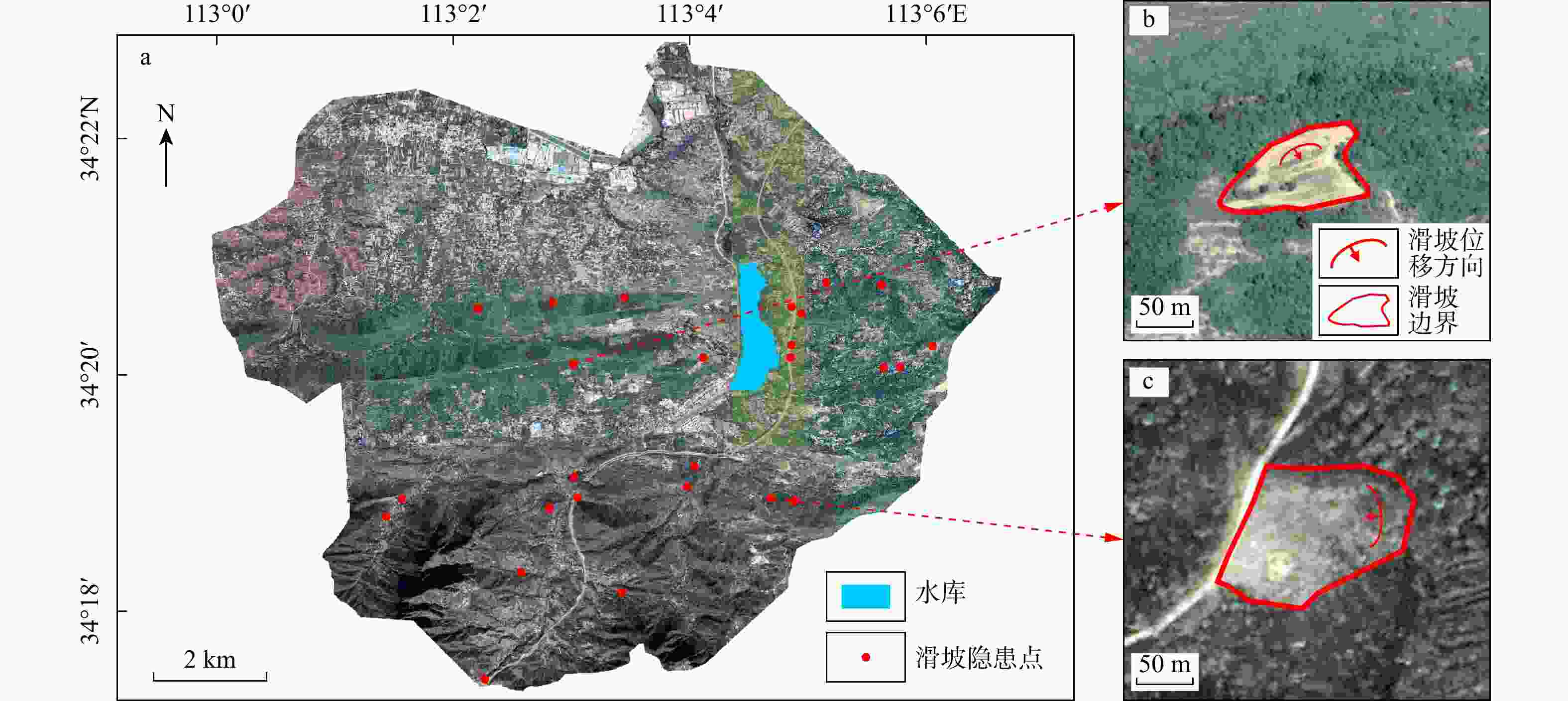
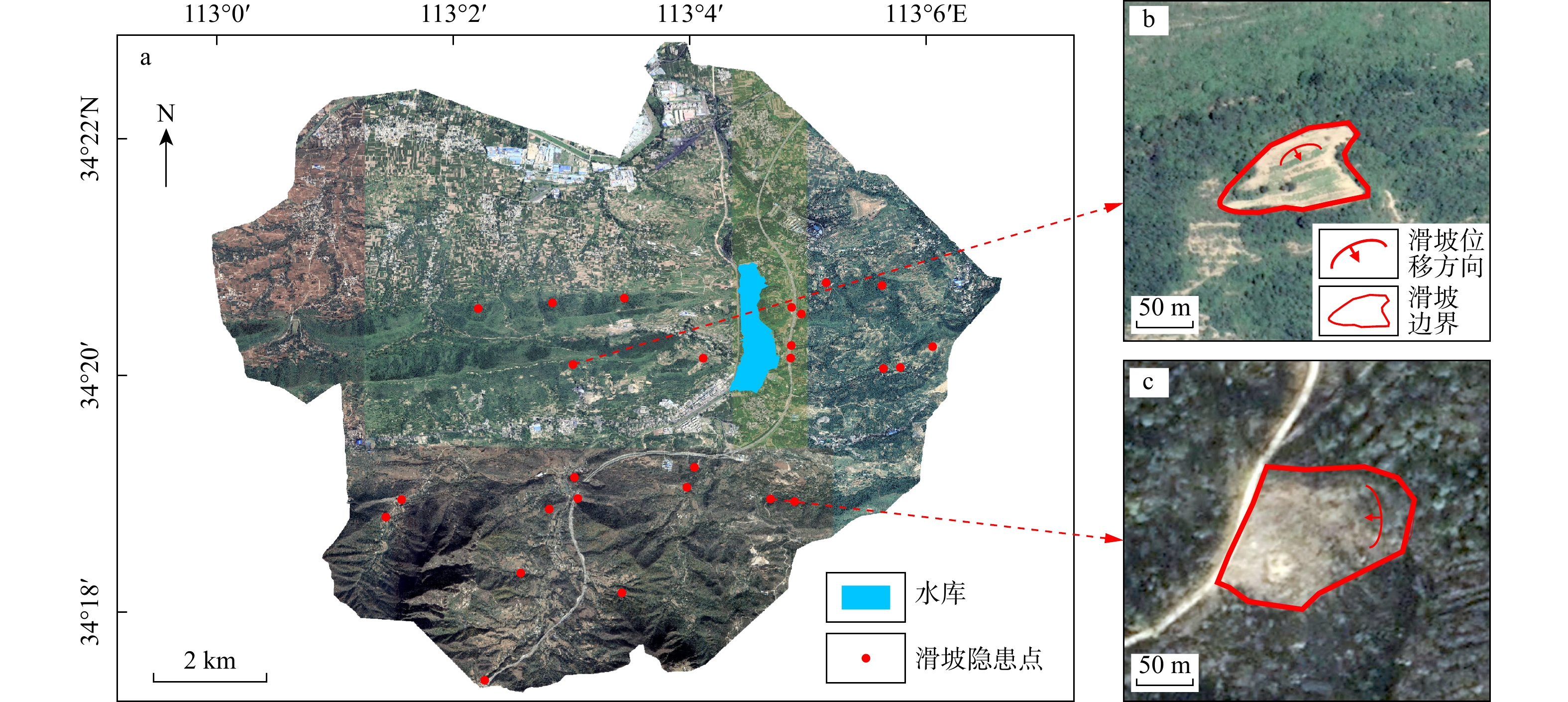
图 2 研究区光学遥感解译滑坡隐患点(a)及部分滑坡展示(b~c)
Figure 2. Landslide hazard points interpreted from optical remote sensing (a) and partial landslide display (b-c) in the study area
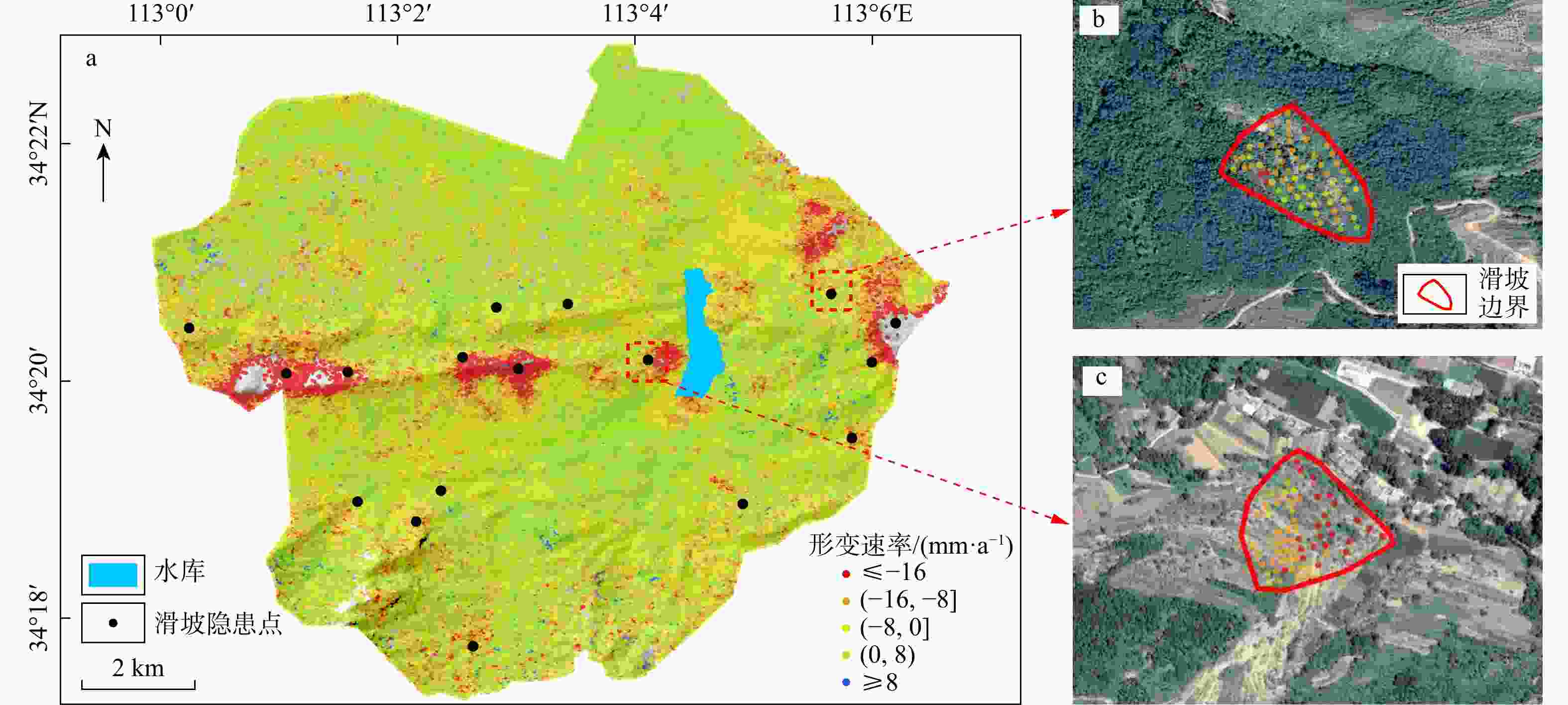
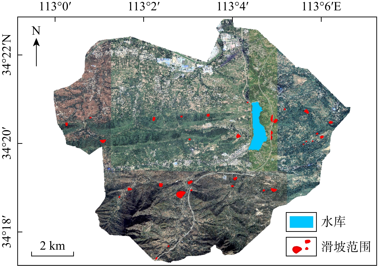
图 3 研究区InSAR解译滑坡隐患点位置(a)及部分滑坡展示(b, c)
Figure 3. Location of landslide hazard sites interpreted from InSAR (a) and display of partial landslides (b, c) in the study area
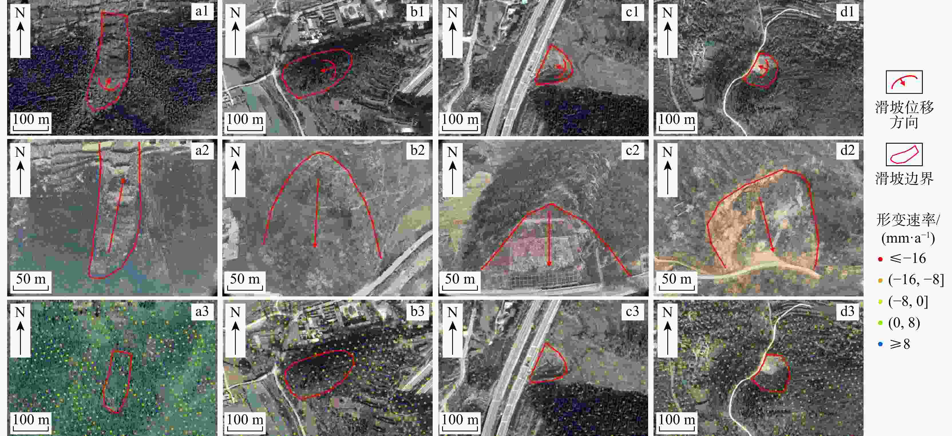
图 4 研究区滑坡灾害隐患点综合解译对比图
a1~d1. 光学遥感解译图;a2~d2. 野外调查图;a3~d3. SBAS-InSAR解译图
Figure 4. Comprehensive interpretation comparison of lanslide hazard sites in the study area
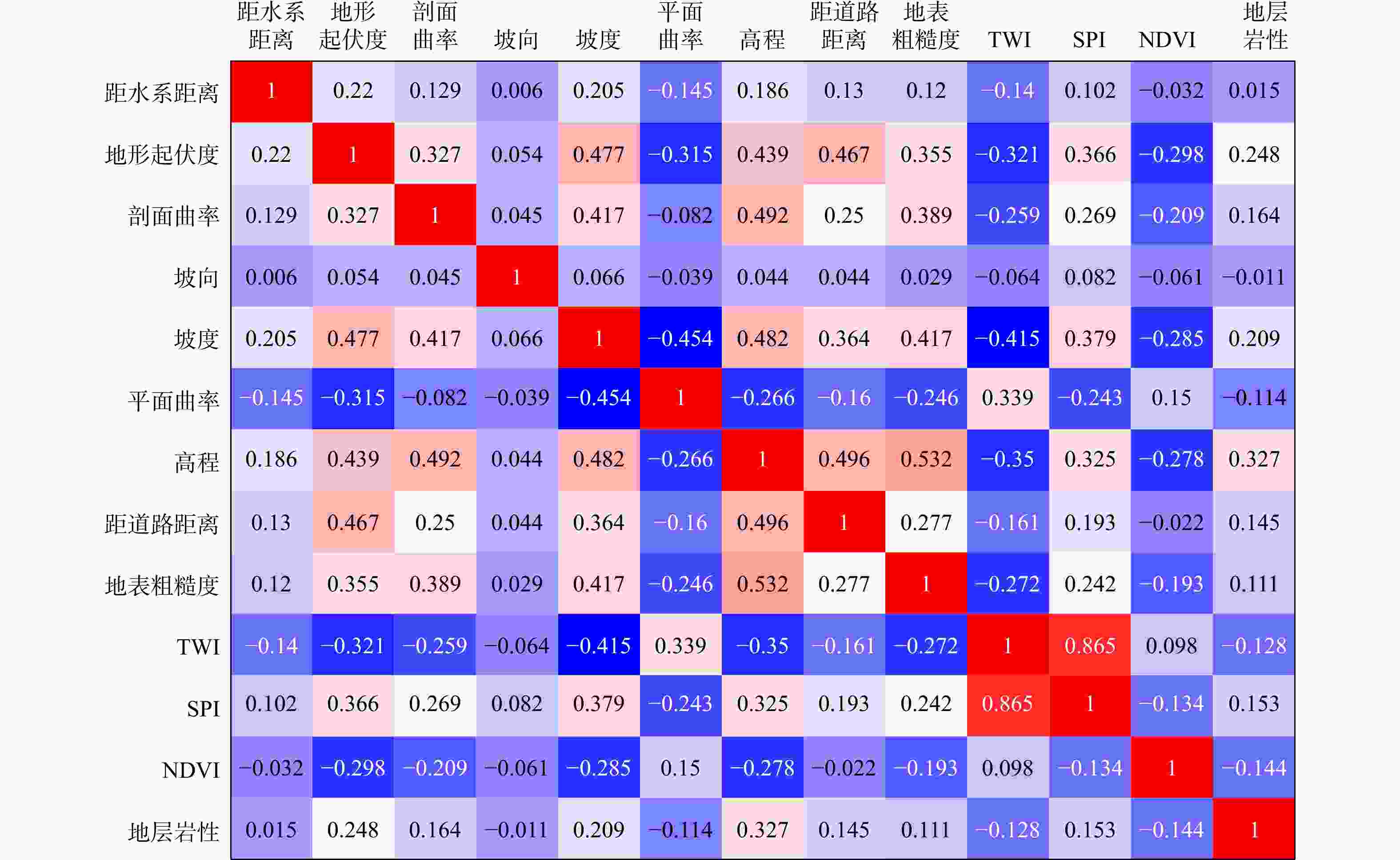
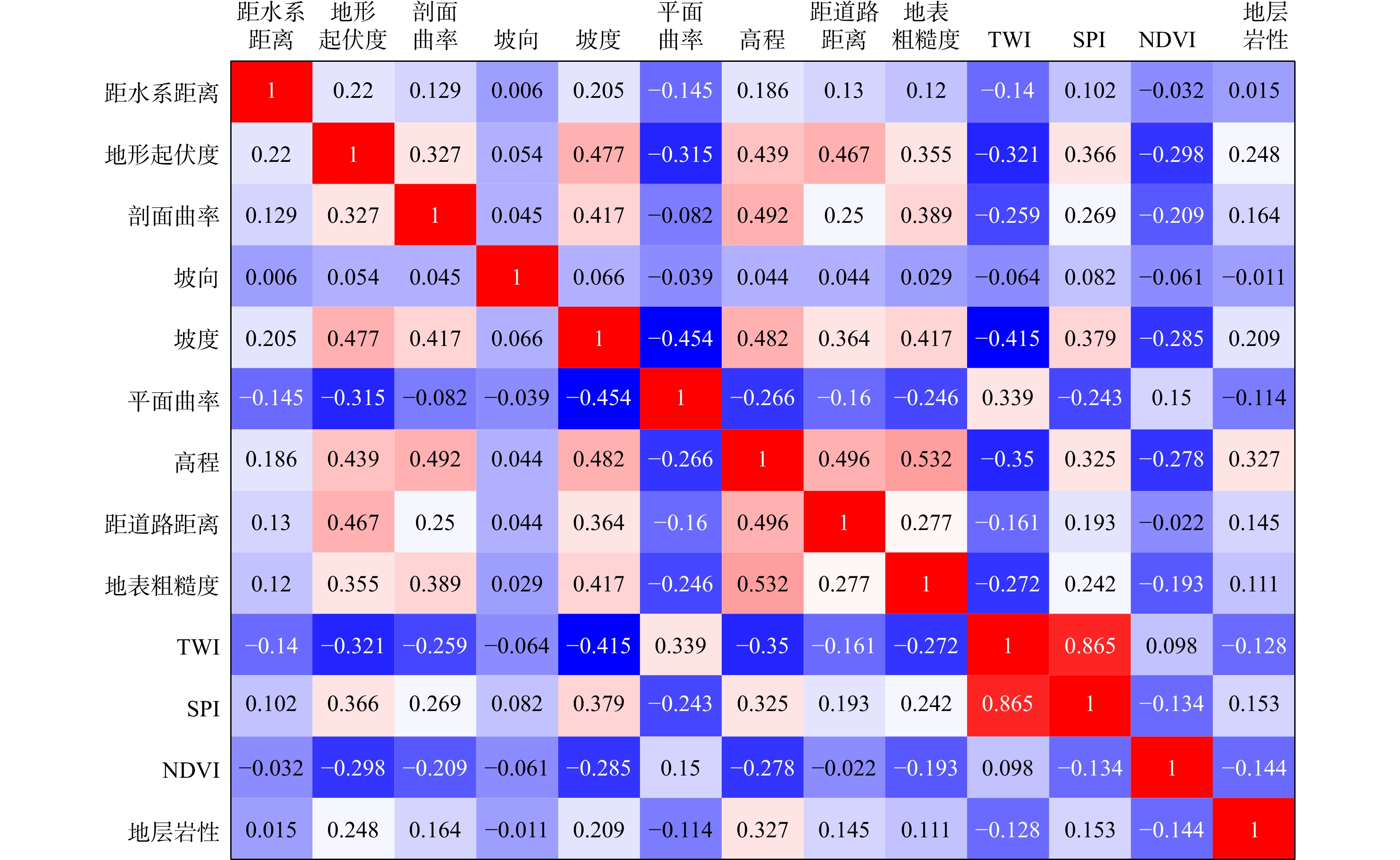
图 7 研究区滑坡各因子间的相关性分析
TWI. 地形湿度指数;SPI. 河流功率指数;NDVI. 归一化植被指数;下同
Figure 7. Correlation analysis among landslide factors in the study area
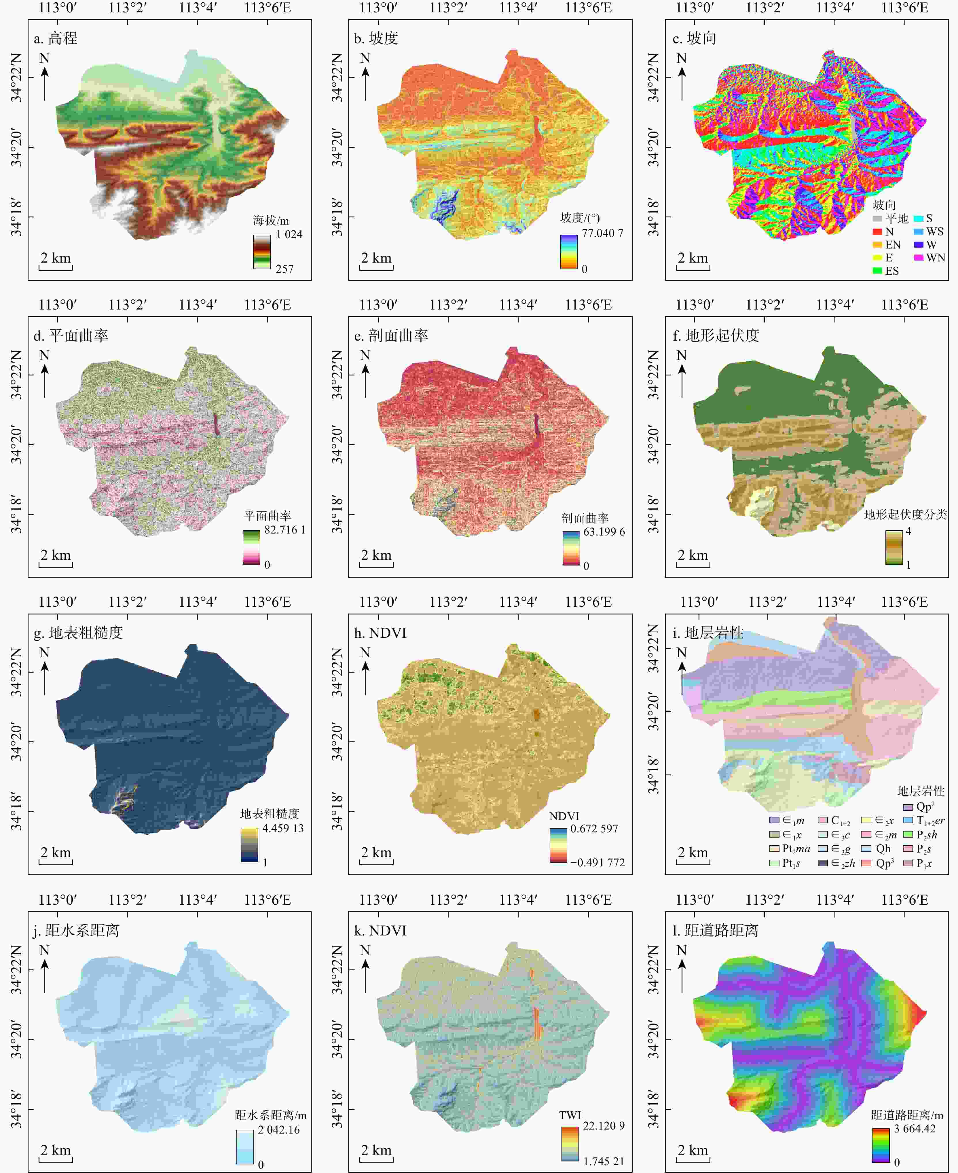
图 8 研究区易发性评价因子
Qh. 第四系全新统;Qp3. 第四系上更新统;Qp2. 第四系中更新统;T1+2er. 三叠系二马营组;P2sh. 上二叠统石千峰组;P2s. 上二叠统上石盒子组;P1x. 下二叠统下石盒子组;C1+2. 中、上石炭统;∈3c. 上寒武统长山组;∈3g. 上寒武统崮山组;∈2zh. 中寒武统张夏组;∈2x. 中寒武统徐庄组;∈2m. 中寒武统毛庄组;∈1m. 下寒武统馒头组;∈1x. 下寒武统辛集组;Pt2ma. 中新元古界五佛山群马鞍山组;Pt1s. 下元古界嵩山群嵩山组;下同。地形起伏度分类:<52 m为1类;[52, 101) m为2类;[196, 421] m为3类;>421 m为4类
Figure 8. Maps of landslide suspecptibility evaluation factors in the study area
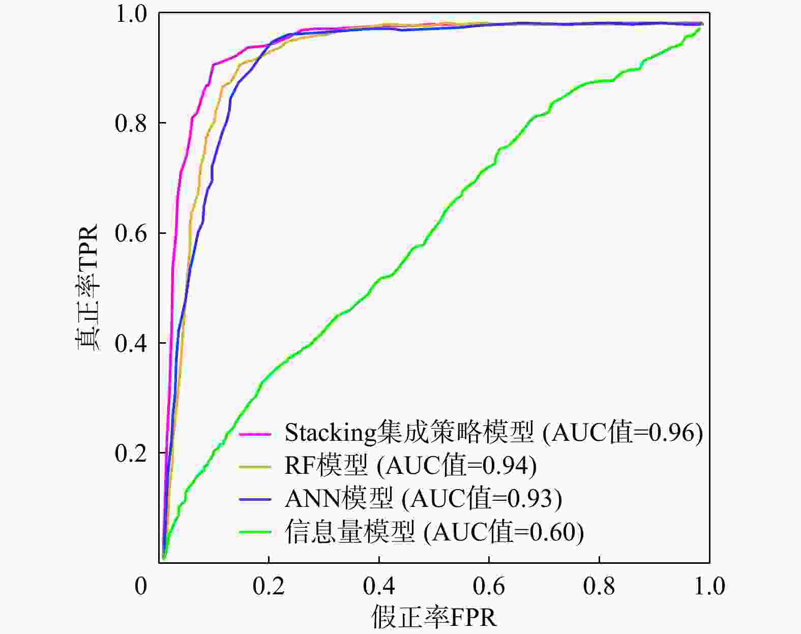
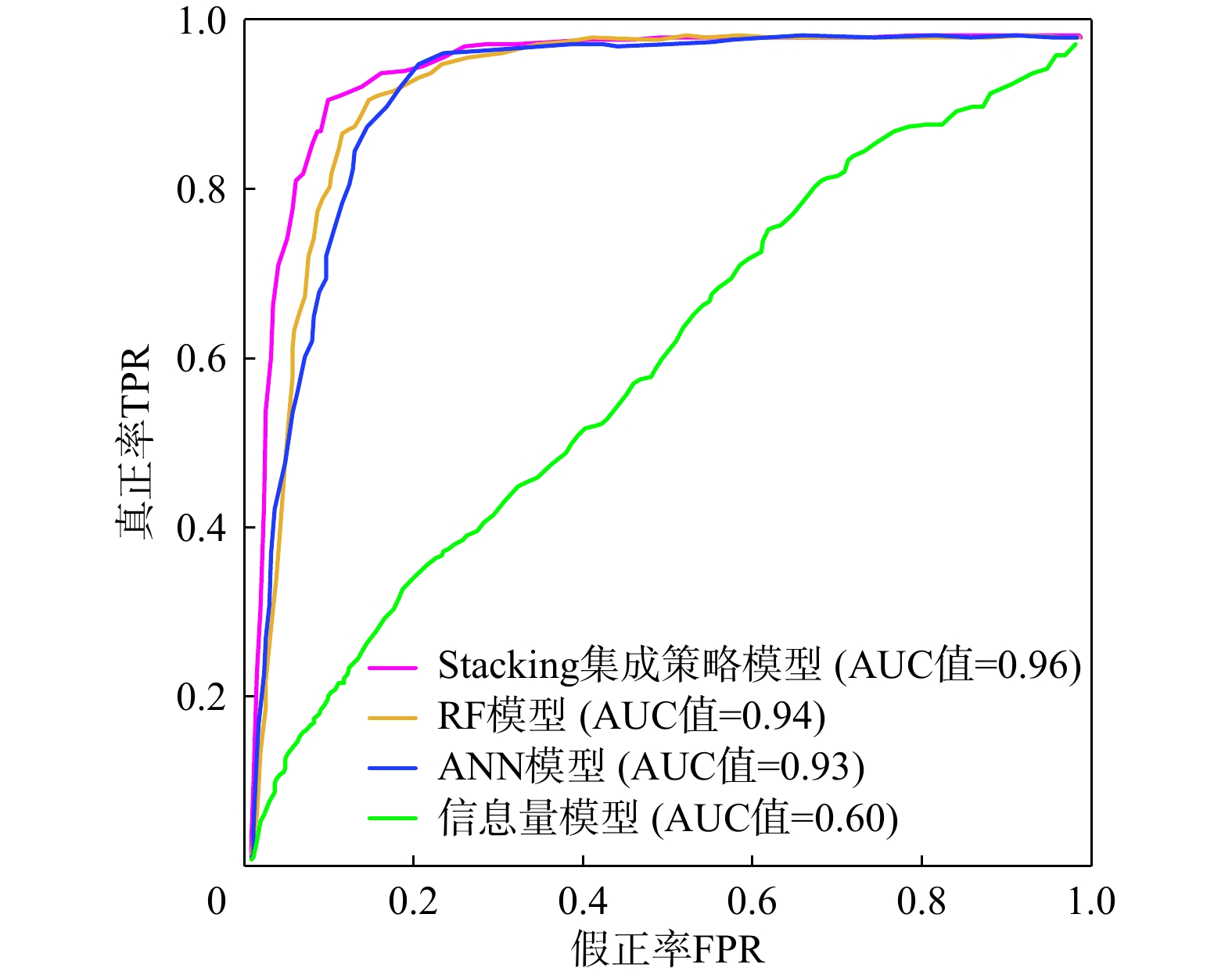
图 10 研究区4种模型滑坡易发性结果ROC曲线对比
RF. 随机森林;ANN. 人工神经网络;AUC. 受试者工作特征曲线下面积;下同
Figure 10. Comparison of ROC curves of landslide susceptibility results from four models in the study area
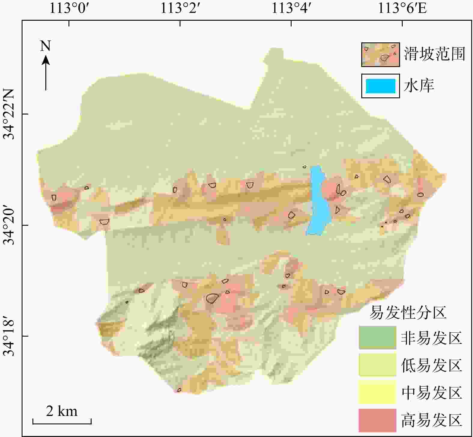
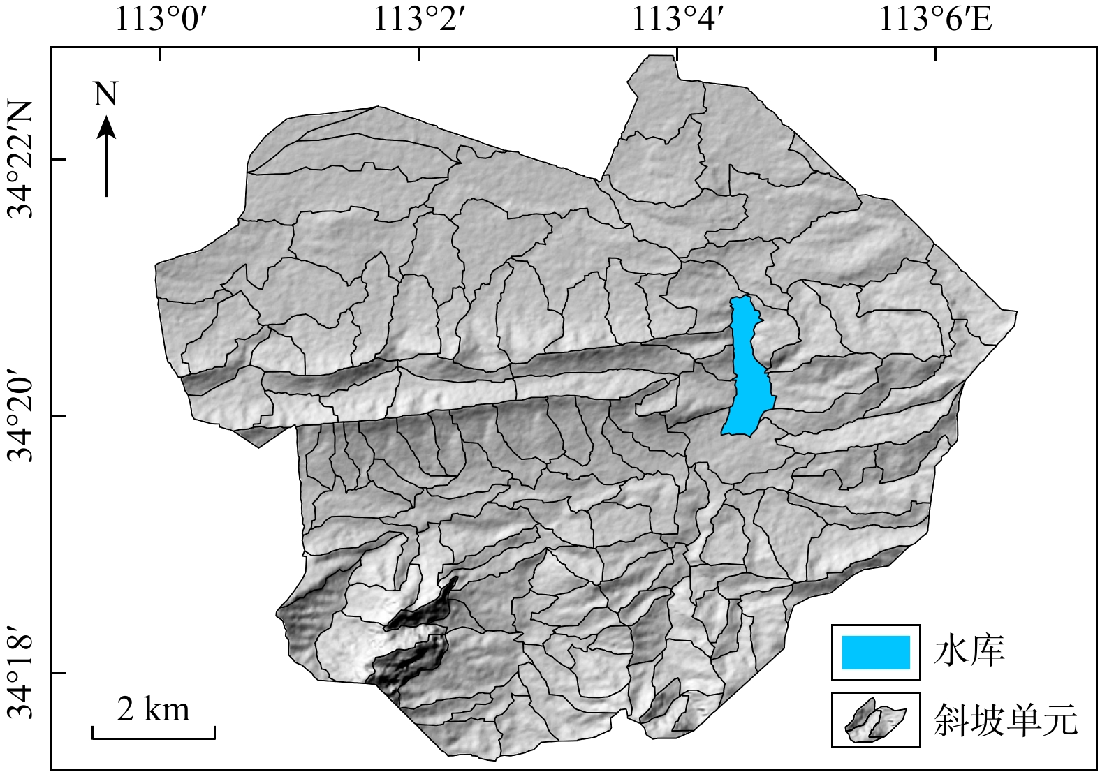
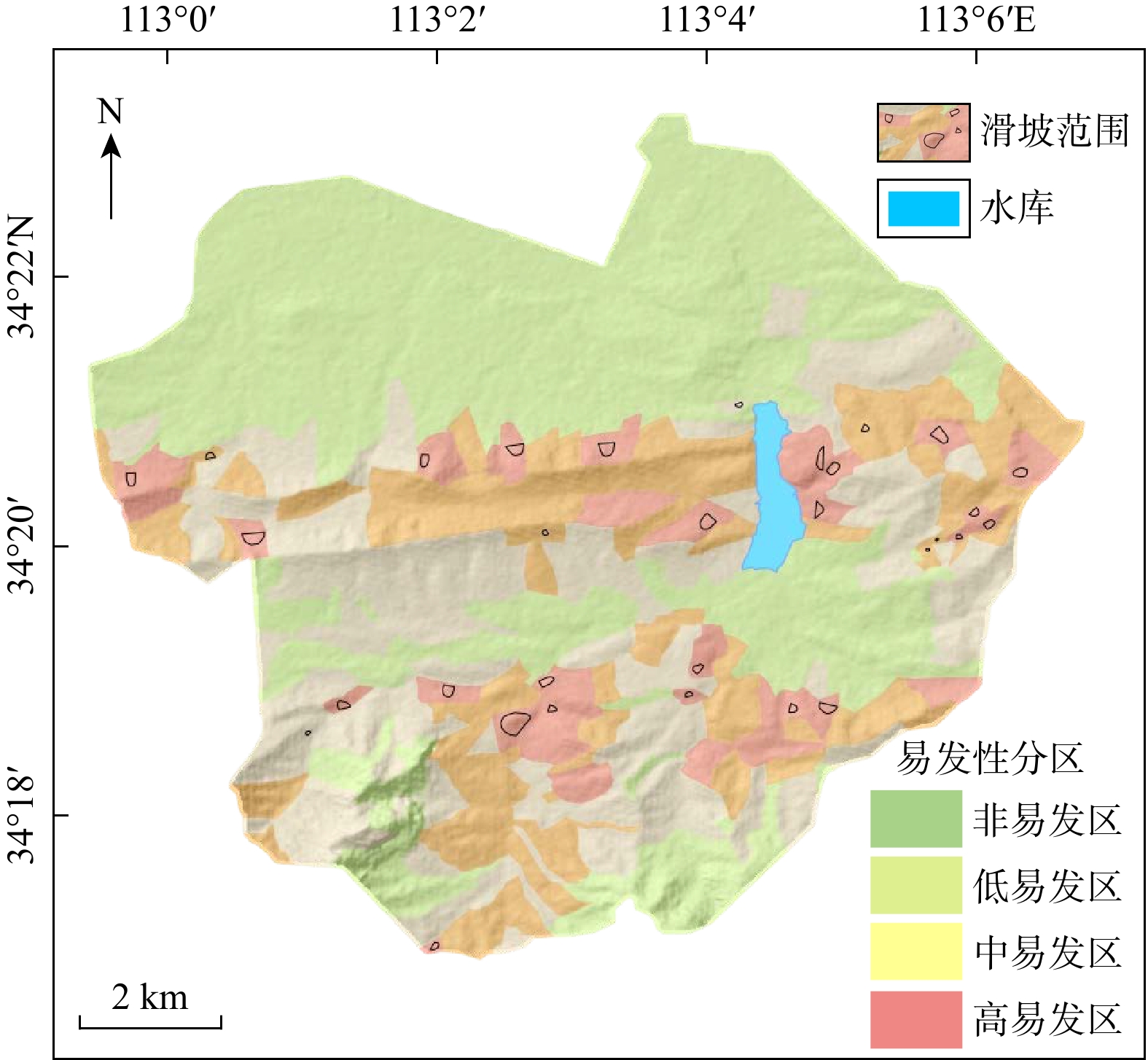
图 11 基于斜坡单元的研究区滑坡易发性分区图
Figure 11. Landslide susceptibility zoning based on slope units in the study area
表 1 研究区遥感数据基本参数
Table 1. Basic parameters of remote sensing data in the study area
参数名称 参数 卫星名称(Satellite) 哨兵1号(Sentinel-1) 成像方向(Direction) Ascending (升轨) 成像方式(Mode) IW (干涉宽幅模式) 轨道(Path) 113 图幅(Frame) 106 极化方式(Polarization) VV+VH (垂直发射−垂直
接收+垂直发射−水平接收) 下载: 导出CSV
表 2 研究区滑坡信息量计算结果
Table 2. Information value calculation results of landslides in the study area
评价因子 因子分级 滑坡数
量/个滑坡数
量比/%栅格数
量/个栅格面
积比/%信息量 评价因子 因子分级 滑坡数
量/个滑坡数
量比/%栅格数
量/个栅格面
积比/%信息量 高程/m <374 2 6.45 117043 37.81 − 1.783450 NDVI <−0.03 8 45.16 60927 19.80 0.815328 [374, 482) 20 64.52 109631 35.42 0.584560 [−0.03, 0.12) 14 48.39 169622 55.12 − 0.139570 [482, 640] 9 29.03 68689 22.19 0.253583 [−0.12, 0.33] 15 6.45 45810 14.89 − 0.845410 640 0 0 14193 4.58 0 >0.33 2 0 31369 10.19 0 坡度/(°) <8 3 9.68 141728 46.13 − 1.569350 地层岩性 ∈1m 0 0 3439 1.12 0 [8, 17) 14 45.16 101916 33.17 0.300856 ∈1x 0 0 5030 1.63 0 [17, 30] 14 45.16 52553 17.10 0.963183 ∈2m 1 3.23 632 0.21 2.744813 >30 0 0 11071 3.60 0 ∈2x 0 0 1718 0.56 0 坡向 平面 1 3.23 11460 3.73 − 0.152920 ∈2zh 2 6.45 5457 1.77 1.282195 N 7 22.58 61347 19.97 0.115311 ∈3c 1 3.23 5852 1.90 0.519164 EN 6 19.35 41431 13.48 0.353678 ∈3g 3 9.68 13328 4.32 0.794693 E 0 0 30724 10.00 0 C1+2 1 3.23 5818 1.89 0.524991 ES 4 12.90 30218 9.83 0.263804 P1x 1 3.23 22864 7.42 − 0.843620 S 4 12.90 32641 10.62 0.186673 P2s 13 41.94 56275 18.26 0.820646 WS 1 3.23 24068 7.83 − 0.894940 P2sh 4 12.90 23283 7.55 0.524518 W 4 12.90 31098 10.12 0.235098 Pt1s 0 0 12341 4.00 0 WN 4 12.90 44281 14.41 − 0.118310 Pt2ma 1 3.23 10806 3.51 − 0.094150 平面曲率 <24.33 10 32.26 62641 20.53 0.451113 Qh 0 0 12288 3.99 0 [24.33, 41.84) 7 22.58 85952 28.18 − 0.221930 Qp3 3 9.68 99845 32.40 − 1.219060 [41.84, 59.69] 7 22.58 87117 28.56 − 0.235390 Qp2 1 3.23 27997 9.08 − 1.046150 >59.69 7 22.58 69342 22.73 − 0.007190 T1+2er 0 0 1231 0.40 0 剖面曲率 <6.20 11 35.48 133098 43.63 − 0.207240 距水系距离/m <288 15 48.39 117978 38.28 0.223499 [6.2, 12.8) 9 29.03 105269 34.51 − 0.173350 [288,640) 3 9.68 100820 32.71 − 1.228780 [12.8, 22.3] 8 25.81 51315 16.82 0.427406 [640, 1105 ]11 35.48 65932 21.39 0.495219 >22.3 3 9.68 15370 5.04 0.652142 > 1105 2 6.45 23474 7.62 − 0.176800 地形起伏度/m <52 2 6.45 142430 46.21 − 1.979760 TWI <5.9 14 45.16 138612 45.11 − 0.006670 [52, 101) 18 58.06 104917 34.04 0.523150 [5.9, 8.3) 12 38.71 120741 39.30 − 0.022790 [196, 421] 11 35.48 52023 16.88 0.732157 [8.3, 12.1] 3 9.68 35277 11.48 − 0.178670 >421 0 0 8834 2.87 0 >12.1 2 6.45 12638 4.11 0.442386 地表粗糙度 <1.07 22 70.97 264968 86.23 − 0.202620 距道路距离/m <546 10 32.26 126526 41.12 − 0.251920 [1.07, 1.33) 9 29.03 39131 12.74 0.816257 [546, 1207 ]7 22.58 83842 27.25 − 0.197080 [1.33, 2.07] 0 0 2964 0.96 0 [ 1207 ,1997 ]9 29.03 66576 21.64 0.284828 >2.07 0 0 205 0.07 0 > 1997 5 16.13 30762 10.00 0.469105
下载: 导出CSV
表 3 研究区各模型滑坡易发性分区统计
Table 3. Statistical results of landslide susceptibility zoning of different models in the study area
模型类别 易发性
分级分区栅
格数分区百
分比/%滑坡栅
格数占总滑坡
栅格百分比/%频率
比值信息量模型 非易发区 86768 28.46 0 0 0 低易发区 60720 19.92 74 4.73 0.24 中易发区 105066 34.46 616 39.39 1.14 高易发区 52331 17.16 874 55.88 3.26 ANN模型 非易发区 206325 67.67 81 5.18 0.08 低易发区 37629 12.34 65 4.16 0.34 中易发区 21035 6.90 198 12.66 1.83 高易发区 39896 13.09 1220 78.01 5.96 RF模型 非易发区 192354 63.09 66 4.22 0.07 低易发区 28515 9.35 52 3.32 0.36 中易发区 46218 15.16 233 14.90 0.98 高易发区 37798 12.40 1213 77.56 6.26 Stacking集成
策略模型非易发区 166178 54.51 0 0 0 低易发区 66077 21.67 48 3.07 0.14 中易发区 46395 15.22 144 9.21 0.61 高易发区 26235 8.60 1372 87.72 10.19
下载: 导出CSV
-
[1] FROUDE M J, PETLEY D N. Global fatal landslide occurrence from 2004 to 2016[J]. Natural Hazards and Earth System Sciences, 2018, 18(8): 2161-2181. doi: 10.5194/nhess-18-2161-2018 [2] 张樑. 21世纪中国地质灾害防治形势与减灾战略思考[J]. 中国地质灾害与防治学报, 2004, 15(2): 16-21.ZHANG L. Thought about the geological hazard control situation and hazard-relief strategy of China in 21st century[J]. The Chinese Journal of Geological Hazard and Control, 2004, 15(2): 16-21. (in Chinese with English abstract) [3] 李佳蓓. 嵩山地区新太古界登封群构造环境研究[D]. 河南 焦作: 河南理工大学, 2014.LI J B. Research in tectonic evolutionat of Neoarchean Dengfeng group in Songshan area[D]. Jiaozuo Henan: Henan Polytechnic University, 2014. (in Chinese with English abstract) [4] 许强, 董秀军, 李为乐. 基于天−空−地一体化的重大地质灾害隐患早期识别与监测预警[J]. 武汉大学学报(信息科学版), 2019, 44(7): 957-966.XU Q, DONG X J, LI W Y. Integrated space-air-ground early detection, monitoring and warning system for potential catastrophic geohazards[J]. Geomatics and Information Science of Wuhan University, 2019, 44(7): 957-966. (in Chinese with English abstract) [5] 王润生, 熊盛青, 聂洪峰, 等. 遥感地质勘查技术与应用研究[J]. 地质学报, 2011, 85(11): 1699-1743.WANG R S, XIONG S Q, NIE H F, et al. Remote sensing technology and its application in geological exploration[J]. Acta Geologica Sinica, 2011, 85(11): 1699-1743. (in Chinese with English abstract) [6] 葛大庆, 戴可人, 郭兆成, 等. 重大地质灾害隐患早期识别中综合遥感应用的思考与建议[J]. 武汉大学学报(信息科学版), 2019, 44(7): 949-956.GE D Q, DAI K R, GUO Z C, et al. Early identification of serious geological hazards with integrated remote sensing technologies: Thoughts and recommendations[J]. Geomatics and Information Science of Wuhan University, 2019, 44(7): 949-956. (in Chinese with English abstract) [7] BERARDINO P, FORNARO G, LANARI R, et al. A new algorithm for surface deformation monitoring based on small baseline differential SAR interferograms[J]. IEEE Transactions on Geoscience and Remote Sensing, 2002, 40(11): 2375-2383. doi: 10.1109/TGRS.2002.803792 [8] 张路, 廖明生, 董杰, 等. 基于时间序列InSAR分析的西部山区滑坡灾害隐患早期识别: 以四川丹巴为例[J]. 武汉大学学报(信息科学版), 2018, 43(12): 2039-2049.ZHANG L, LIAO M S, DONG J, et al. Early identification of landslide hazards in western mountainous areas based on time series InSAR analysis: A case study of Danba, Sichuan[J]. Geomatics and Information Science of Wuhan University, 2018, 43(12): 2039-2049. (in Chinese with English abstract) [9] 王之栋, 唐伟, 马志刚, 等. 九寨沟地区高位滑坡隐患InSAR-LiDAR早期识别[J]. 测绘通报, 2023(5): 9-15.WANG Z D, TANG W, MA Z G, et al. Early identification of ridge-top landslide hazards in Jiuzhaigou area using InSAR-LiDAR method[J]. Bulletin of Surveying and Mapping, 2023(5): 9-15. (in Chinese with English abstract) [10] 魏旭, 彭志忠, 刘兴臣, 等. 泸石高速公路沿线历史地震诱发滑坡遥感调查及发育分布规律[J]. 地质科技通报, 2024, 43(2): 386-396. doi: 10.19509/j.cnki.dzkq.tb20220653WEI X, PENG Z Z, LIU X C, et al. Remote sensing investigation and development distribution of historical earthquake-induced landslides along Lushi Expressway[J]. Bulletin of Geological Science and Technology, 2024, 43(2): 386-396. (in Chinese with English abstract) doi: 10.19509/j.cnki.dzkq.tb20220653 [11] 杨芳, 丁仁军, 李勇发. 基于SBAS-InSAR技术的金沙江流域典型滑坡时空演化特征分析[J]. 测绘通报, 2024(11): 102-107. doi: 10.13474/j.cnki.11-2246.2024.1118YANG F, DING R J, LI Y F. Analysis of spatiotemporal evolution characteristics of typical landslides in the Jinsha River Basin based on SBAS-InSAR technology[J]. Bulletin of Surveying and Mapping, 2024(11): 102-107. (in Chinese with English abstract) doi: 10.13474/j.cnki.11-2246.2024.1118 [12] 何秀凤, 高壮, 肖儒雅, 等. InSAR与北斗/GNSS综合方法监测地表形变研究现状与展望[J]. 测绘学报, 2022, 51(7): 1338-1355.HE X F, GAO Z, XIAO R Y, et al. Current status and prospects of ground deformation monitoring using InSAR and BeiDou/GNSS integrated methods[J]. Acta Geodaetica et Cartographica Sinica, 2022, 51(7): 1338-1355. (in Chinese with English abstract) [13] BIANCHINI S, HERRERA G, MATEOS R, et al. Landslide activity maps generation by means of persistent scatterer interferometry[J]. Remote Sensing, 2013, 5(12): 6198-6222. doi: 10.3390/rs5126198 [14] REICHENBACH P, ROSSI M, MALAMUD B D, et al. A review of statistically-based landslide susceptibility models[J]. Earth-Science Reviews, 2018, 180: 60-91. doi: 10.1016/j.earscirev.2018.03.001 [15] PHAM B T, TIEN BUI D, PRAKASH I, et al. Hybrid integration of multilayer perceptron neural networks and machine learning ensembles for landslide susceptibility assessment at Himalayan area (India) using GIS[J]. Catena, 2017, 149: 52-63. doi: 10.1016/j.catena.2016.09.007 [16] ZHANG T Y, HAN L, ZHANG H, et al. GIS-based landslide susceptibility mapping using hybrid integration approaches of fractal dimension with index of entropy and support vector machine[J]. Journal of Mountain Science, 2019, 16(6): 1275-1288. doi: 10.1007/s11629-018-5337-z [17] 黄发明, 陈杰, 杨阳, 等. 滑坡易发性相关致灾环境因子研究的综述与展望[J]. 地质科技通报, 2025, 44(2): 14-37. doi: 10.19509/j.cnki.dzkq.tb20240766HUANG F M, CHEN J, YANG Y, et al. A review and prospect of disaster-causing environmental factors related to landslide susceptibility prediction[J]. Bulletin of Geological Science and Technology, 2025, 44(2): 14-37. (in Chinese with English abstract) doi: 10.19509/j.cnki.dzkq.tb20240766 [18] 蒋根, 肖诗荣, 杨璇喆, 等. 基于机器学习的湖北省巴东县滑坡易发性评价[J]. 水利水电快报, 2024, 45(11): 48-55.JIANG G, XIAO S R, YANG X Z, et al. Vulnerability evaluation of landslide disaster in Badong County based on machine learning[J]. Express Water Resources & Hydropower Information, 2024, 45(11): 48-55. (in Chinese with English abstract) [19] YU L B, WANG Y, PRADHAN B. Enhancing landslide susceptibility mapping incorporating landslide typology via stacking ensemble machine learning in Three Gorges Reservoir, China[J]. Geoscience Frontiers, 2024, 15(4): 101802. doi: 10.1016/j.gsf.2024.101802 [20] ZHAO Z Y, CHEN T, DOU J, et al. Landslide susceptibility mapping considering landslide local-global features based on CNN and transformer[J]. IEEE Journal of Selected Topics in Applied Earth Observations and Remote Sensing, 2024, 17: 7475-7489. doi: 10.1109/JSTARS.2024.3379350 [21] ZHAO F M, MENG X M, ZHANG Y, et al. Landslide susceptibility mapping of Karakorum Highway combined with the application of SBAS-InSAR technology[J]. Sensors, 2019, 19(12): 2685. doi: 10.3390/s19122685 [22] 张锦瑞, 汪洋, 冯霄, 等. 考虑地表形变和土地利用变更的滑坡时空易发性差异分析[J]. 地质科技通报, 2024, 43(6): 184-195. doi: 10.19509/j.cnki.dzkq.tb20240195ZHANG J R, WANG Y, FENG X, et al. Analysis of spatial-temporal variations in landslide susceptibility assessment considering surface deformation and land use dynamics[J]. Bulletin of Geological Science and Technology, 2024, 43(6): 184-195. (in Chinese with English abstract) doi: 10.19509/j.cnki.dzkq.tb20240195 [23] SHENG Y F, XU G L, JIN B J, et al. Data-driven landslide spatial prediction and deformation monitoring: A case study of Shiyan City, China[J]. Remote Sensing, 2023, 15(21): 5256. doi: 10.3390/rs15215256 [24] WASOWSKI J, BOVENGA F. Investigating landslides and unstable slopes with satellite multi temporal interferometry: Current issues and future perspectives[J]. Engineering Geology, 2014, 174: 103-138. doi: 10.1016/j.enggeo.2014.03.003 [25] 曹文庚, 潘登, 徐郅杰, 等. 河南省滑坡灾害易发性制图研究: 多种机器学习模型的对比[J]. 地质科技通报, 2025, 44(1): 101-111.CAO W G, PAN D, XU Z J, et al. Landslide disaster vulnerability mapping study in Henan Province: Comparison of different machine learning models[J]. Bulletin of Geological Science and Technology, 2025, 44(1): 101-111. (in Chinese with English abstract) [26] 胡国超. 遥感技术在“5.12”地震重灾区汶川县地质灾害调查中的应用[D]. 成都: 成都理工大学, 2009.HU G C. Application of Remote Sensing Technology in the Investigation of Geological Hazards in Wenchuan County[D]. Chengdu: Chengdu University of Technology, 2009. (in Chinese with English abstract) [27] 陆会燕, 李为乐, 许强, 等. 光学遥感与InSAR结合的金沙江白格滑坡上下游滑坡隐患早期识别[J]. 武汉大学学报(信息科学版), 2019, 44(9): 1342-1354.LU H Y, LI W L, XU Q, et al. Early detection of landslides in the upstream and downstream areas of the Baige landslide, the Jinsha River based on optical remote sensing and InSAR technologies[J]. Geomatics and Information Science of Wuhan University, 2019, 44(9): 1342-1354. (in Chinese with English abstract) [28] 曾斌, 刘诗雅, 董琦, 等. 联合PS-InSAR和SBAS-InSAR的鄂西山区滑坡隐患识别: 以长阳县清江流域为例[J]. 安全与环境工程, 2024, 31(2): 202-212. doi: 10.13578/j.cnki.issn.1671-1556.20230361ZENG B, LIU S Y, DONG Q, et al. Identification of landslide hazards in western Hubei mountainous area by combining PS-InSAR and SBAS-InSAR: Taking Qingjiang River Basin of Changyang County as an example[J]. Safety and Environmental Engineering, 2024, 31(2): 202-212. (in Chinese with English abstract) doi: 10.13578/j.cnki.issn.1671-1556.20230361 [29] 王佳佳, 殷坤龙, 肖莉丽. 基于GIS和信息量的滑坡灾害易发性评价: 以三峡库区万州区为例[J]. 岩石力学与工程学报, 2014, 33(4): 797-808.WANG J J, YIN K L, XIAO L L. Landslide susceptibility assessment based on GIS and weighted information value: A case study of Wanzhou District, Three Gorges Reservoir[J]. Chinese Journal of Rock Mechanics and Engineering, 2014, 33(4): 797-808. (in Chinese with English abstract) [30] 党杰, 陆安良, 李蕊, 等. 人工神经网络在贵州地质灾害易发性分析中的应用探索[J]. 贵州地质, 2024, 41(1): 67-74.DANG J, LU A L, LI R, et al. Application exploration of artificial neural network in the analysis of the susceptibility of geological disasters in Guizhou[J]. Guizhou Geology, 2024, 41(1): 67-74. (in Chinese with English abstract) [31] 曾韬睿, 邬礼扬, 金必晶, 等. 基于Stacking集成策略和SBAS-InSAR的滑坡动态易发性制图[J]. 岩石力学与工程学报, 2023, 42(9): 2266-2282.ZENG T R, WU L Y, JIN B J, et al. Landslide dynamic susceptibility mapping based on Stacking ensemble strategy and SBAS-InSAR[J]. Chinese Journal of Rock Mechanics and Engineering, 2023, 42(9): 2266-2282. (in Chinese with English abstract) [32] 刘艺梁, 殷坤龙, 刘斌. 逻辑回归和人工神经网络模型在滑坡灾害空间预测中的应用[J]. 水文地质工程地质, 2010, 37(5): 92-96.LIU Y L, YIN K L, LIU B. Application of logistic regression and artificial neural networks in spatial assessment of landslide hazards[J]. Hydrogeology and Engineering Geology, 2010, 37(5): 92-96. (in Chinese with English abstract) [33] ZHAO F C, MIAO F S, WU Y P, et al. Landslide dynamic susceptibility mapping in urban expansion area considering spatiotemporal land use and land cover change[J]. Science of the Total Environment, 2024, 949: 175059. [34] HUANG F M, YAN J, FAN X M, et al. Uncertainty law of landslide susceptibility prediction modelling: Effects of different landslide boundaries and spatial shape expressions[J]. Geosciences Frontiers, 2021: 10131. [35] ILINCA V, ȘANDRIC I, GHEUCA I. Landslide susceptibility analysis using machine learning: Insights from the bend Subcarpathians-Carpathians, Romania[J]. Geomorphology, 2025, 486: 109872. [36] MIAO F S, RUAN Q Y, WU Y P, et al. Landslide dynamic susceptibility mapping base on machine learning and the PS-InSAR coupling model[J]. Remote Sensing, 2023, 15(22): 5427. [37] HUANG F M, CHEN J W, LIU W P, et al. Regional rainfall-induced landslide hazard warning based on landslide susceptibility mapping and a critical rainfall threshold[J]. Geomorphology, 2022, 408: 108236. [38] HUSSAIN M A, CHEN Z L, ZHOU Y L, et al. Landslide susceptibility mapping using artificial intelligence models: A case study in the Himalayas[J]. Landslides, 2025, 22(6): 2089-2103. [39] GUO Z Z, SHI Y, HUANG F M, et al. Landslide susceptibility zonation method based on C5.0 decision tree and K-means cluster algorithms to improve the efficiency of risk management[J]. Geoscience Frontiers, 2021, 12(6): 101249. [40] ZHAO F C, MIAO F S, WU Y P, et al. Refined landslide susceptibility mapping in township area using ensemble machine learning method under dataset replenishment strategy[J]. Gondwana Research, 2024, 131: 20-37. -

 下载:
下载:





 点击查看大图
计量
- 文章访问数: 369
- PDF下载量: 60
- 被引次数: 0