
 投审稿入口
投审稿入口

Characteristics of typhoon-induced heavy rainfall in Beiliu, Guangxi, and its impact on landslide stability
-
摘要:
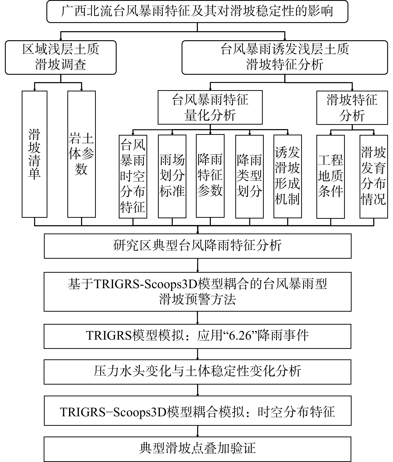
针对台风暴雨诱发花岗岩地区群发性滑坡灾害防控难题,以广西北流市为研究区,聚焦台风暴雨型滑坡的降雨响应机制与风险预警技术开展系统研究。通过台风暴雨事件中降雨时空分布特征及其诱发滑坡机制分析,量化降雨峰度-偏度-峰值位置系数,将台风暴雨分为后峰型、前峰型及集中型3类,构建基于TRIGRS-Scoops3D耦合模型的暴雨条件下区域斜坡稳定性评价方法,并以2023年“6・26”降雨事件为例进行了应用验证。结果表明:研究区超50%范围在降雨条件下发生稳定性劣化,其中极不稳定区占比5.73%,高风险区域集中分布于北部、东部及西南部陡坡地貌单元;暴雨诱发的滑坡点均位于基于稳定性评价结果划分的预警区域范围内。本研究提出的基于“降雨模式识别-稳定性量化评估-风险区域动态圈定”的台风暴雨型浅层滑坡预警方法,具有较高可靠性与适用性。研究成果可为台风影响区花岗岩分布区浅层滑坡风险防控、监测预警体系构建及地质灾害应急管理提供科学依据与技术支撑。
-
关键词:
- 台风暴雨型 /
- TRIGRS-Scoops3D耦合 /
- 浅层滑坡 /
- 稳定性 /
- 广西北流
Abstract:ObjectiveTo address the challenges in preventing and controlling mass landslides triggered by typhoon-induced heavy rainfall in granitic regions, this study focuses on Beiliu City, Guangxi Province as the study area, and systematically investigated the rainfall response mechanism and early warning technology of typhoon rainstorm-triggered landslides.
MethodsBy analyzing the spatiotemporal distribution characteristics of rainfall and the mechanisms triggering landslides during typhoon-induced heavy rainfall events, the study quantified the rainfall kurtosis-skewness-peak location coefficient and classified typhoon-induced heavy rainfall into three types: post-peak, pre-peak, and concentrated. A regional slope stability evaluation method under heavy rainfall conditions was developed using the TRIGRS-Scoops3D coupled model. The method was validated using the "6・26" rainfall event in 2023 as an example.
ResultsThe results indicated that over 50% of the study area experienced stability degradation under rainfall conditions, with extremely unstable zones accounting for 5.73%. High-risk areas were concentrated in the northern, eastern, and southwestern steep slope terrain units. All landslide points induced by heavy rainfall were located within the warning zones delineated based on stability evaluation results.
ConclusionThe results indicate that the typhoon-induced shallow landslide early warning method based on "rainfall pattern recognition-quantitative stability assessment-dynamic delineation of risk areas" possesses high reliability and applicability. The research findings provide scientific support for shallow landslide risk prevention and control, monitoring and early warning system development, and emergency management of geological disasters in typhoon-prone granitic regions.
-
Key words:
- typhoon-induced heavy rainfall /
- TRIGRS-Scoops3D coupling /
- shallow landslides /
- stability /
- Guangxi
-
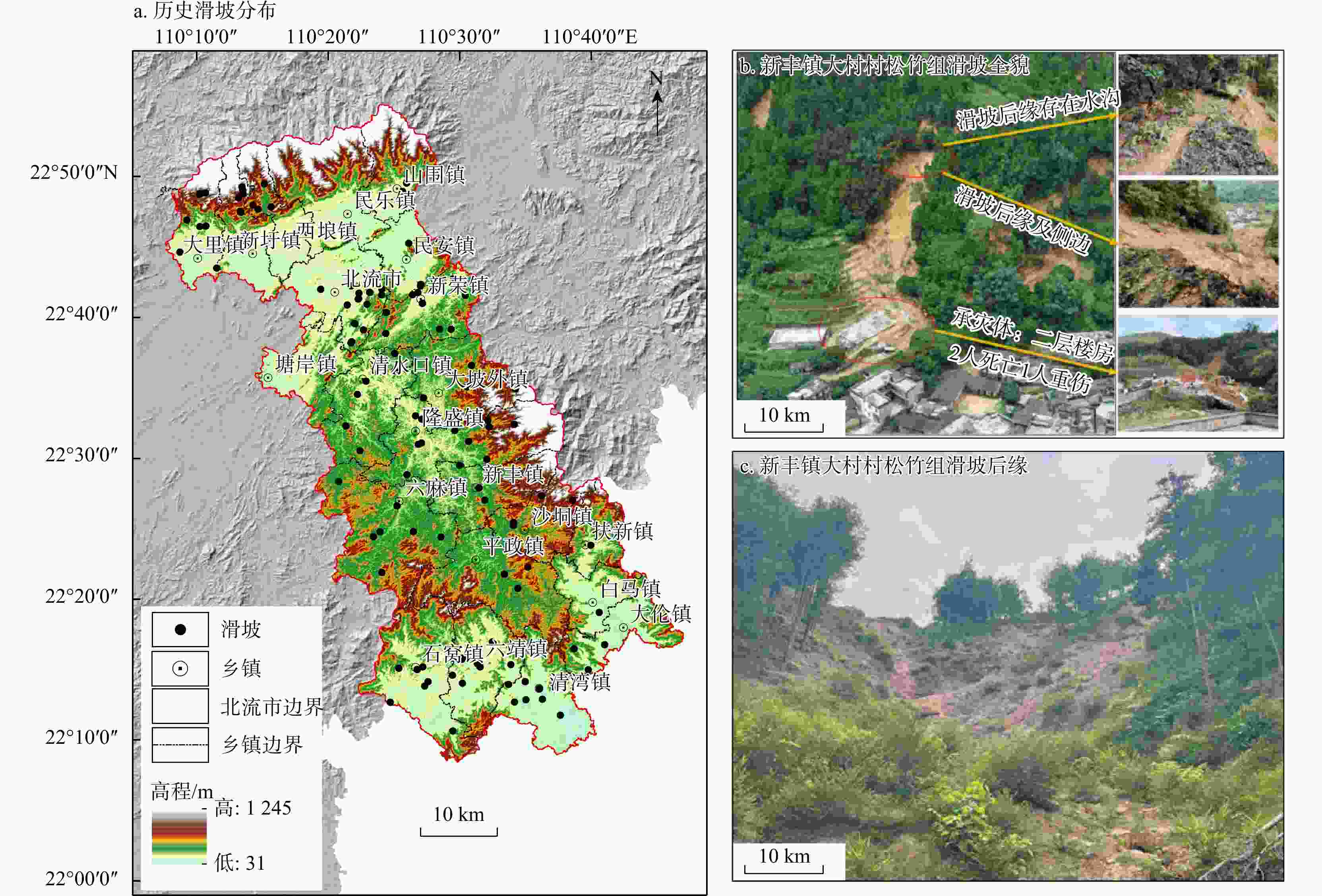
图 1 北流市历史滑坡分布(a)与典型浅层滑坡(b, c)
Figure 1. Historical landslide distribution (a) and typical shallow landslide (b, c) in Beiliu City
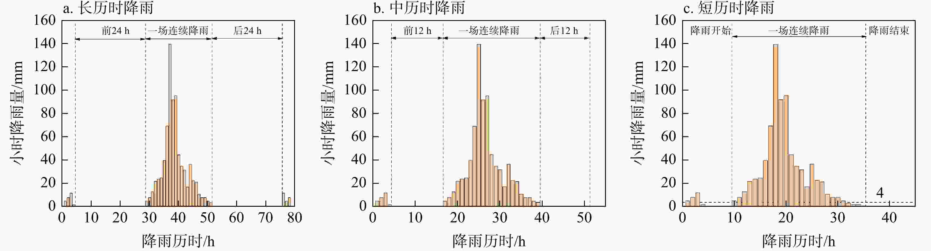
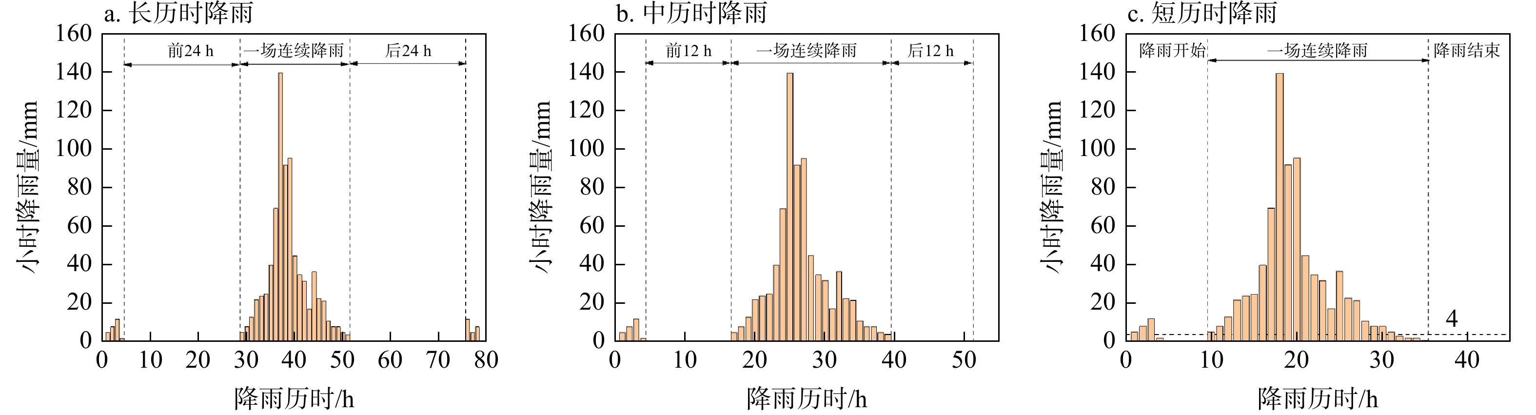
图 4 降雨分析法雨场划分示意图
Figure 4. Schematic diagrams of rainfall event classification using rainfall analysis method
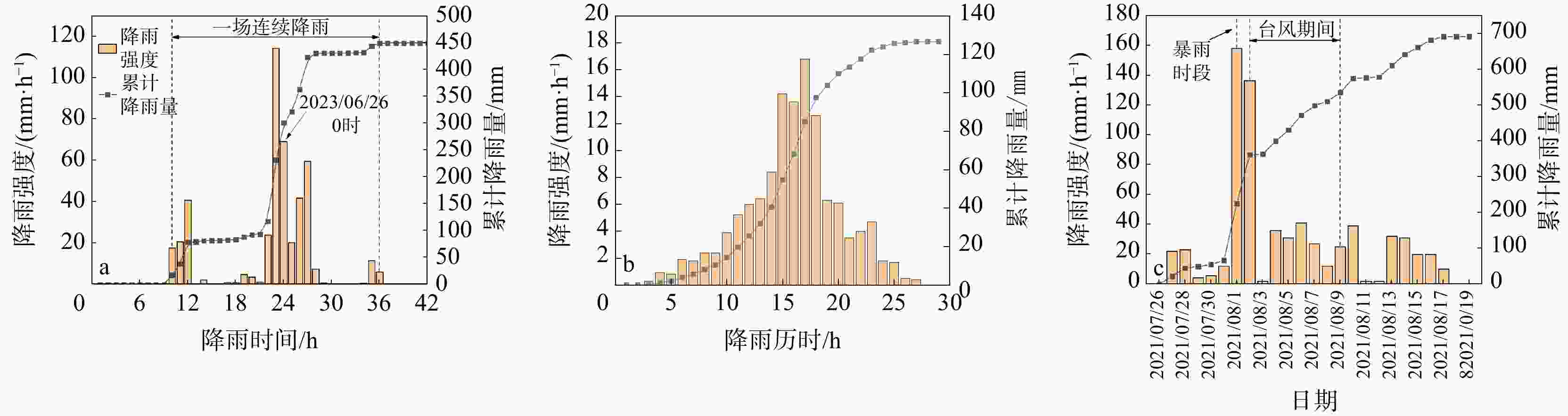
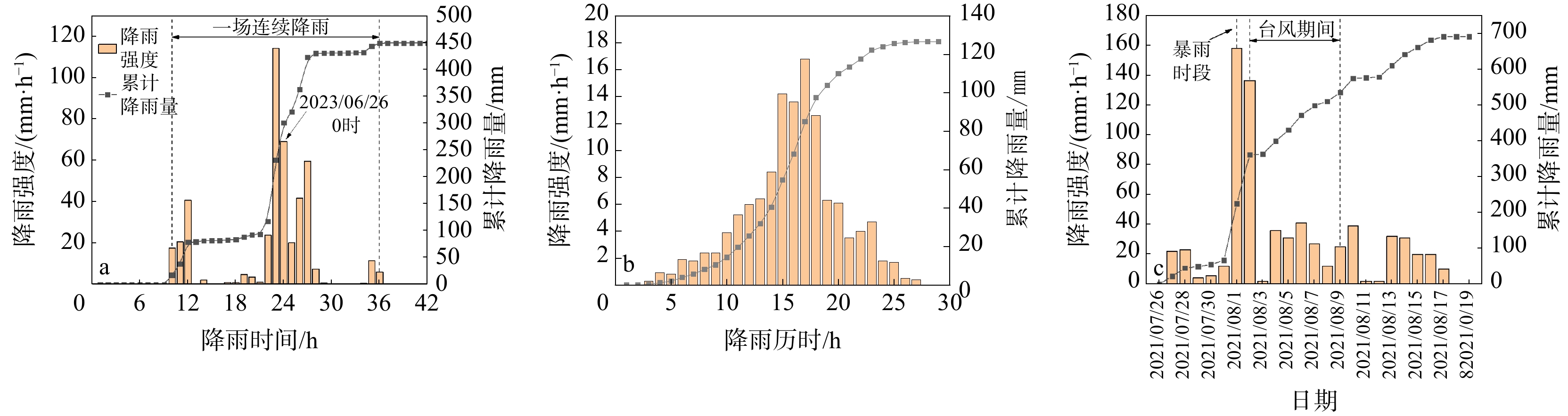
图 5 研究区典型台风暴雨事件雨量统计图
a. “6・26”降雨事件;b. 台风“2203暹芭”事件;c. 暴雨+台风“2109卢碧”事件
Figure 5. Rainfall statistics of typical typhoon-induced rainfall events in study area

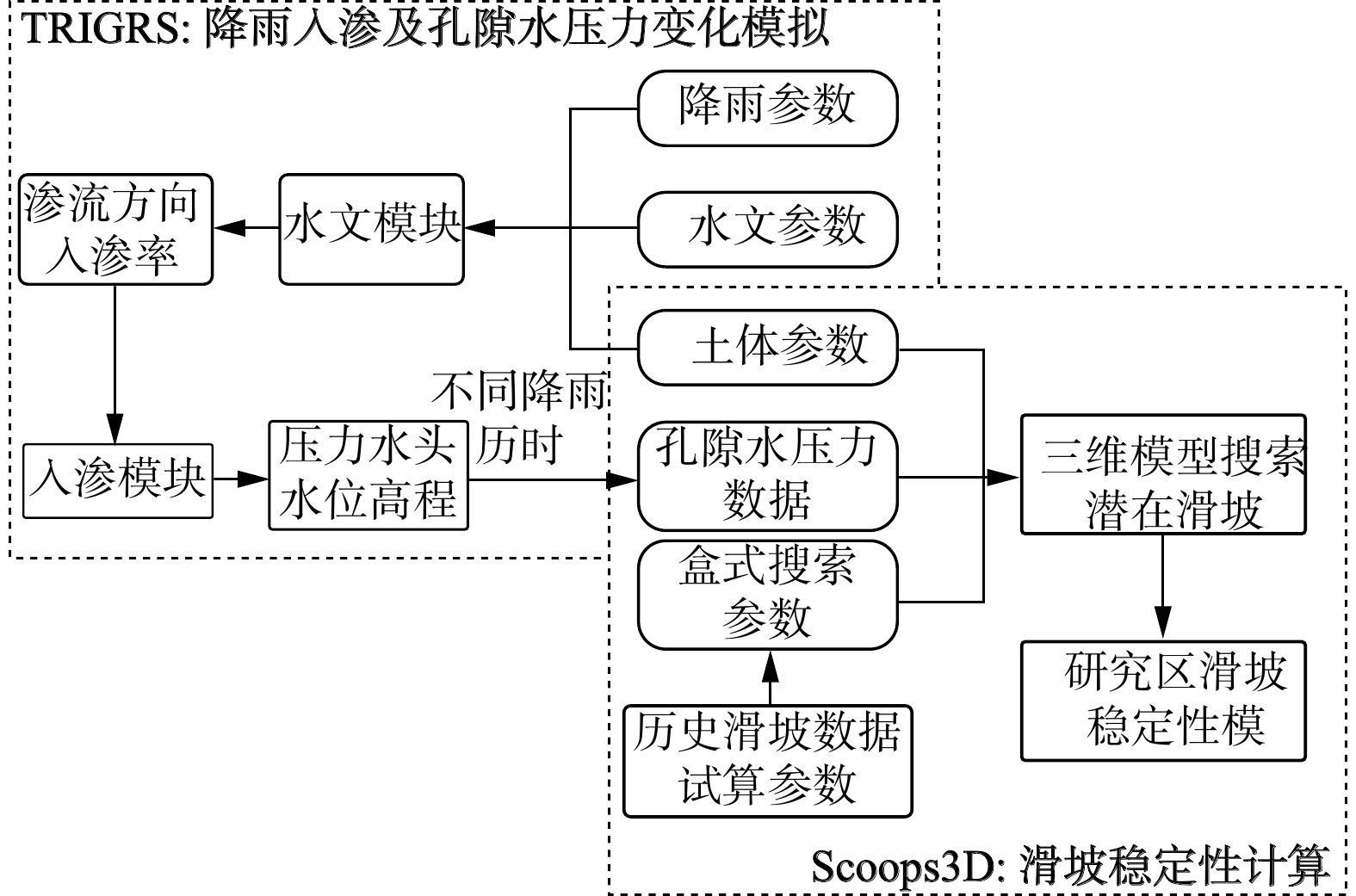
图 6 TRIGRS-Scoops3D模型耦合原理图
Figure 6. Principle diagram of TRIGRS-Scoops3D model coupling
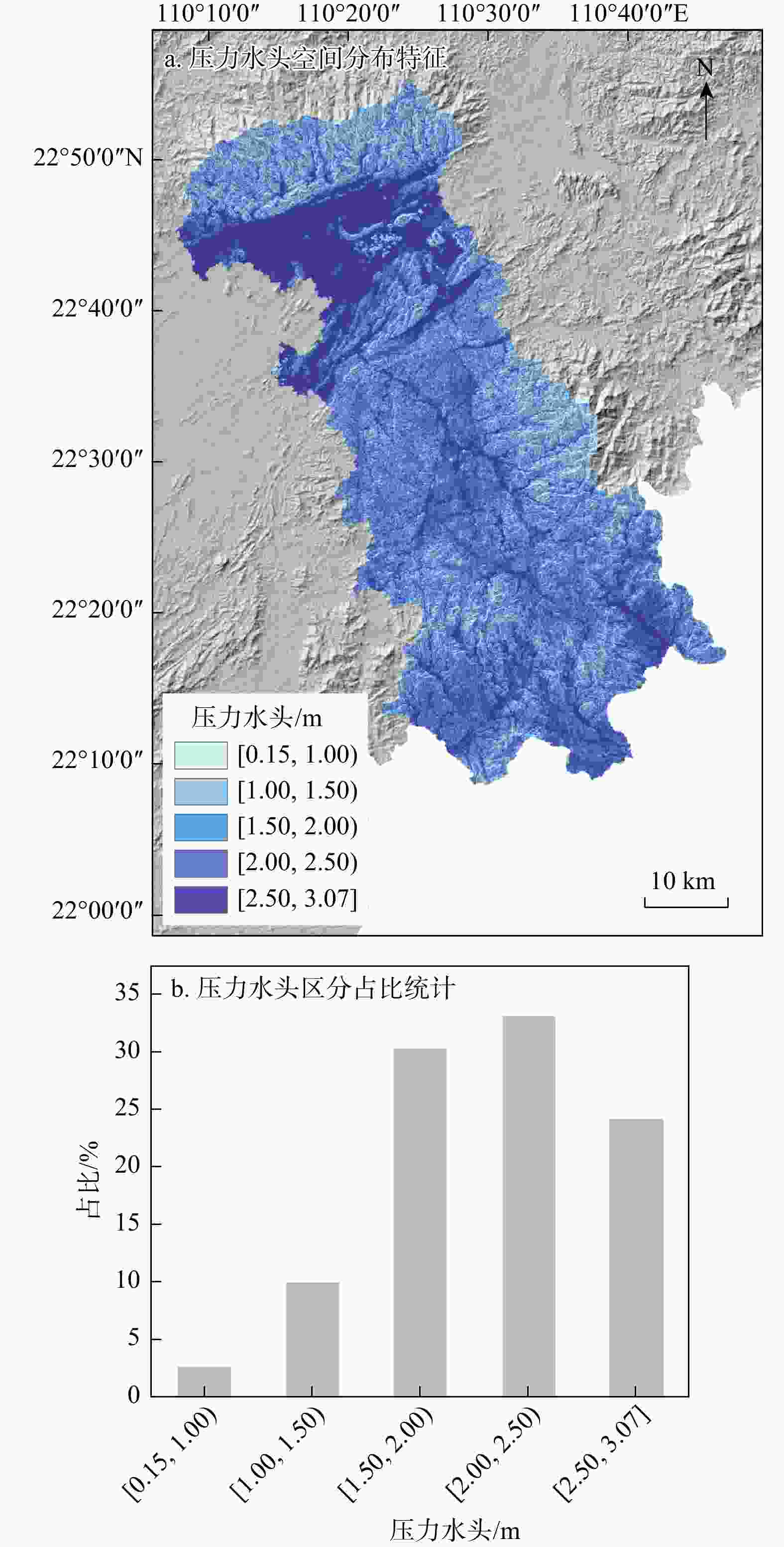
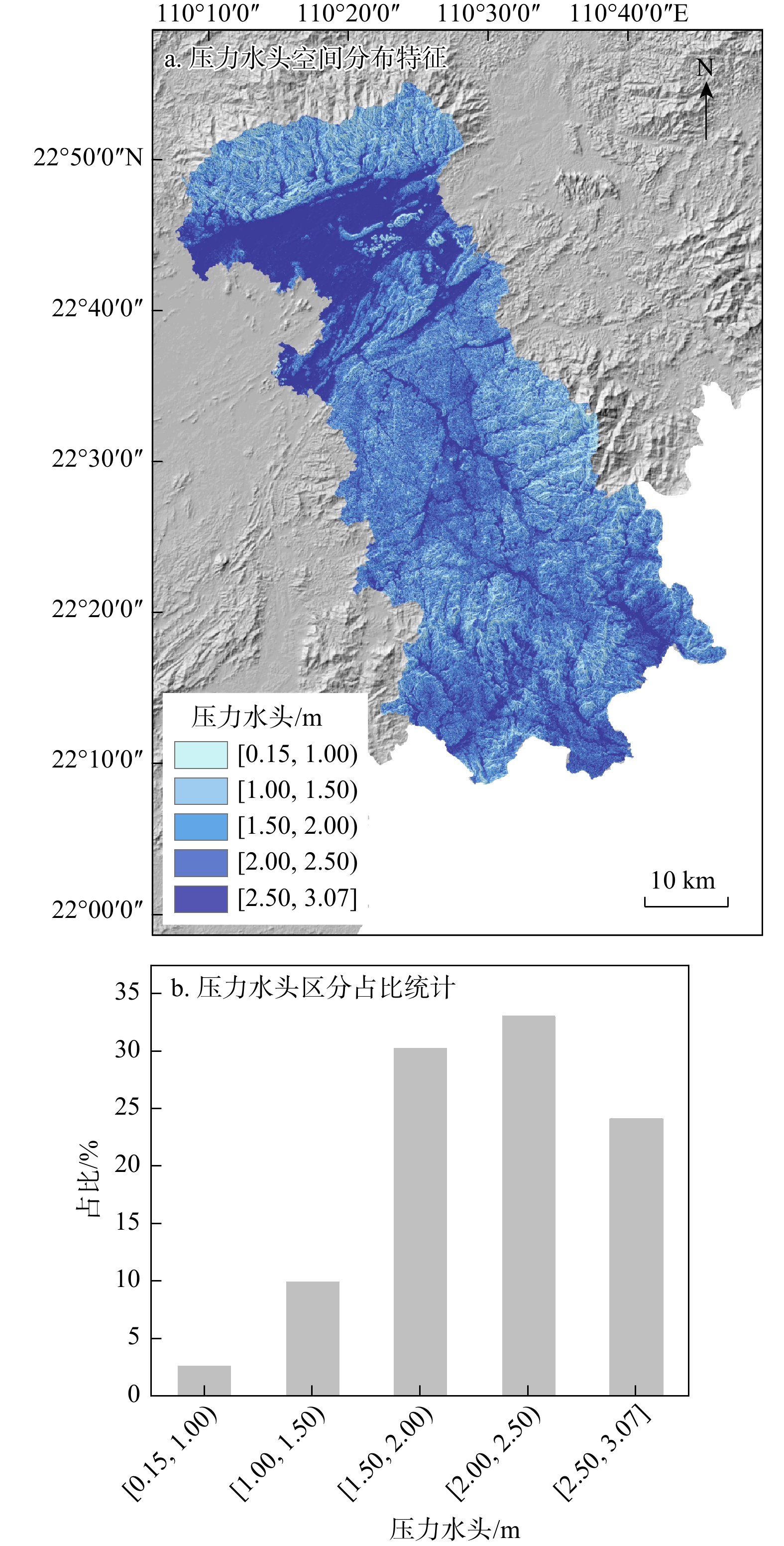
图 7 “6・26”降雨事件下压力水头空间分布特征(a)和压力水头分区占比统计(b)
Figure 7. Spatial distribution characteristics of pressure head (a) and proportion statistics of pressure head zones (b) under the "6·26" rainfall event
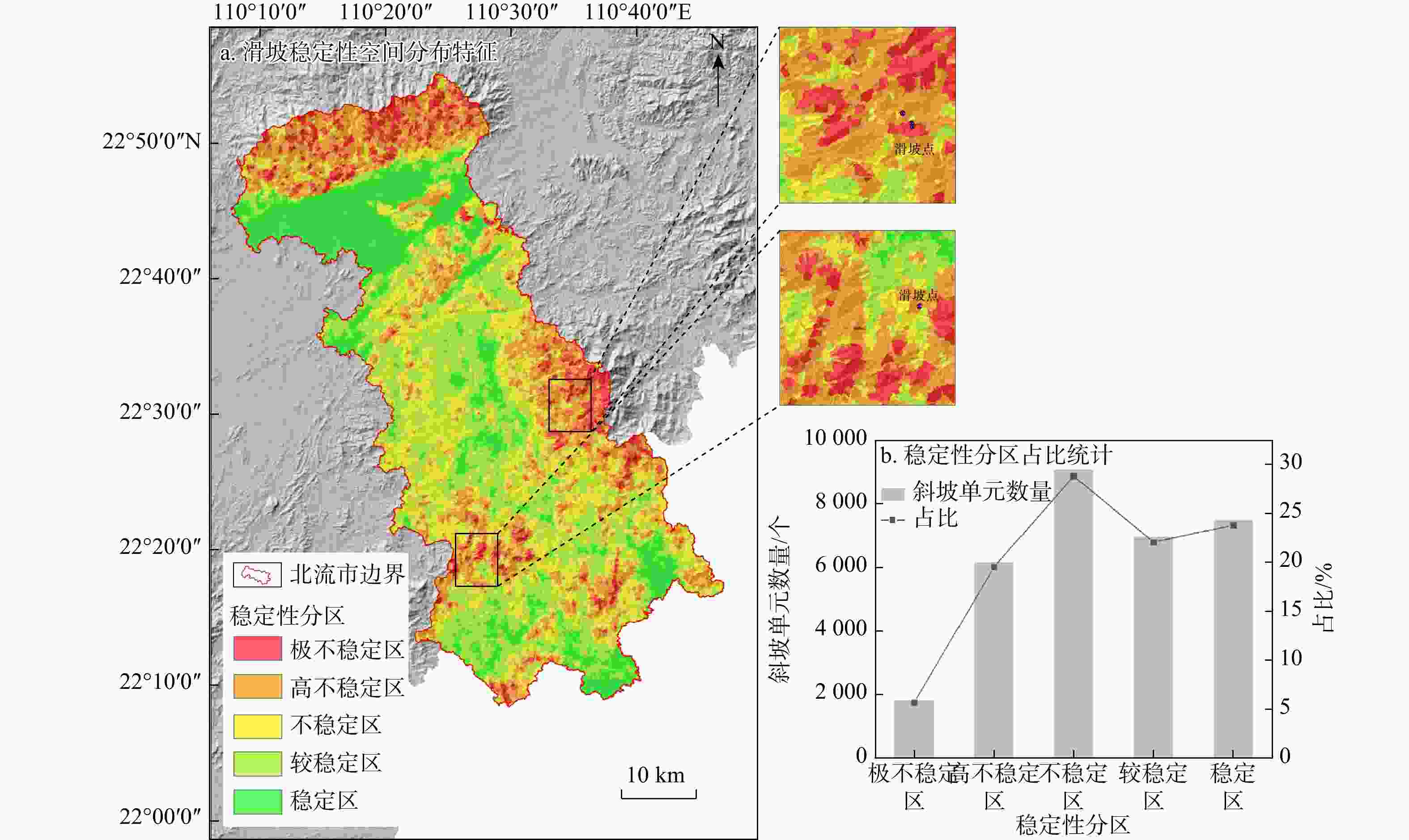
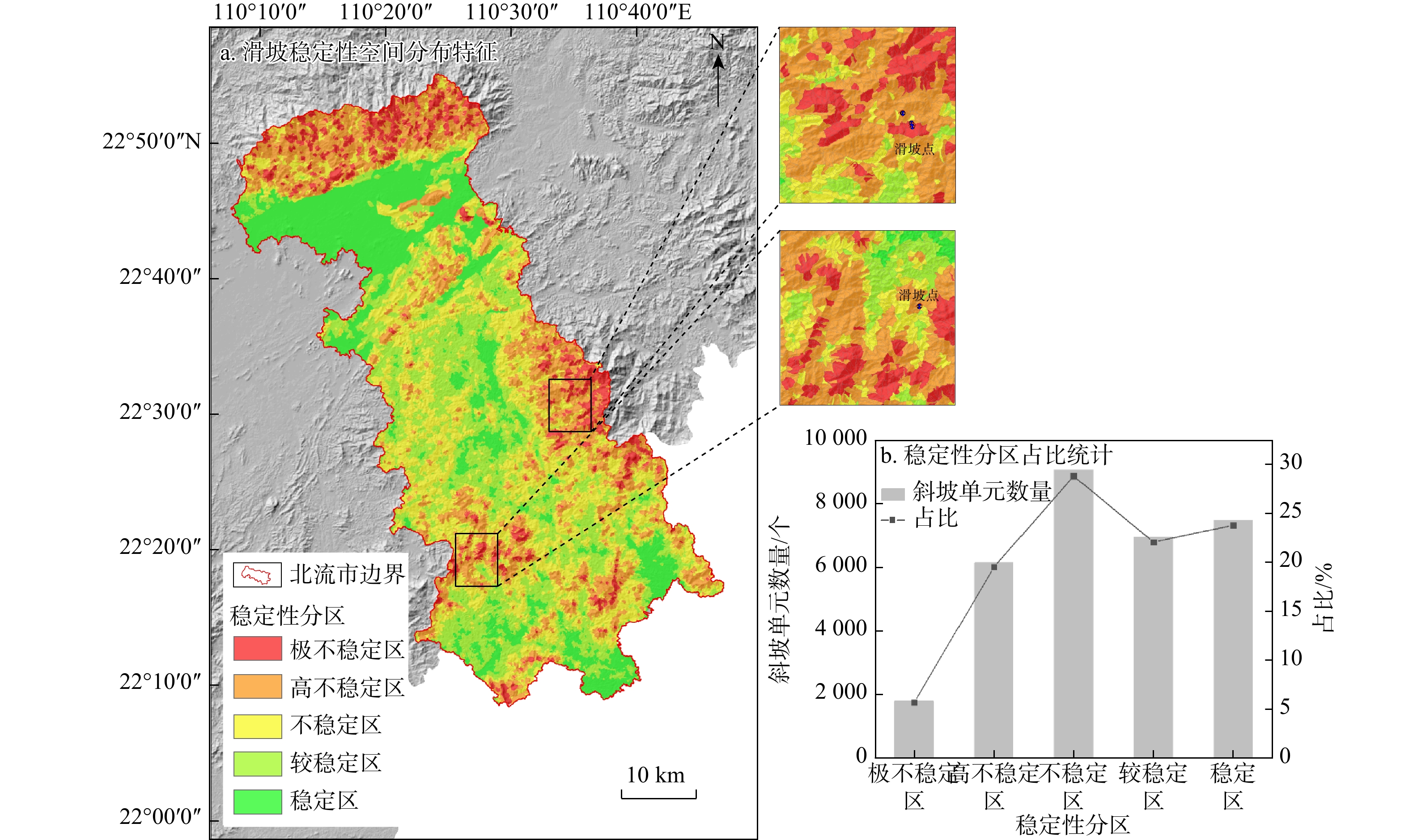
图 8 “6・26”降雨事件下滑坡稳定性空间分布特征(a)和滑坡稳定性分区占比统计(b)
Figure 8. Spatial distribution characteristics of landslide stability (a) and proportion statistics of landslide stability zones under the "6・26" rainfall event (b)
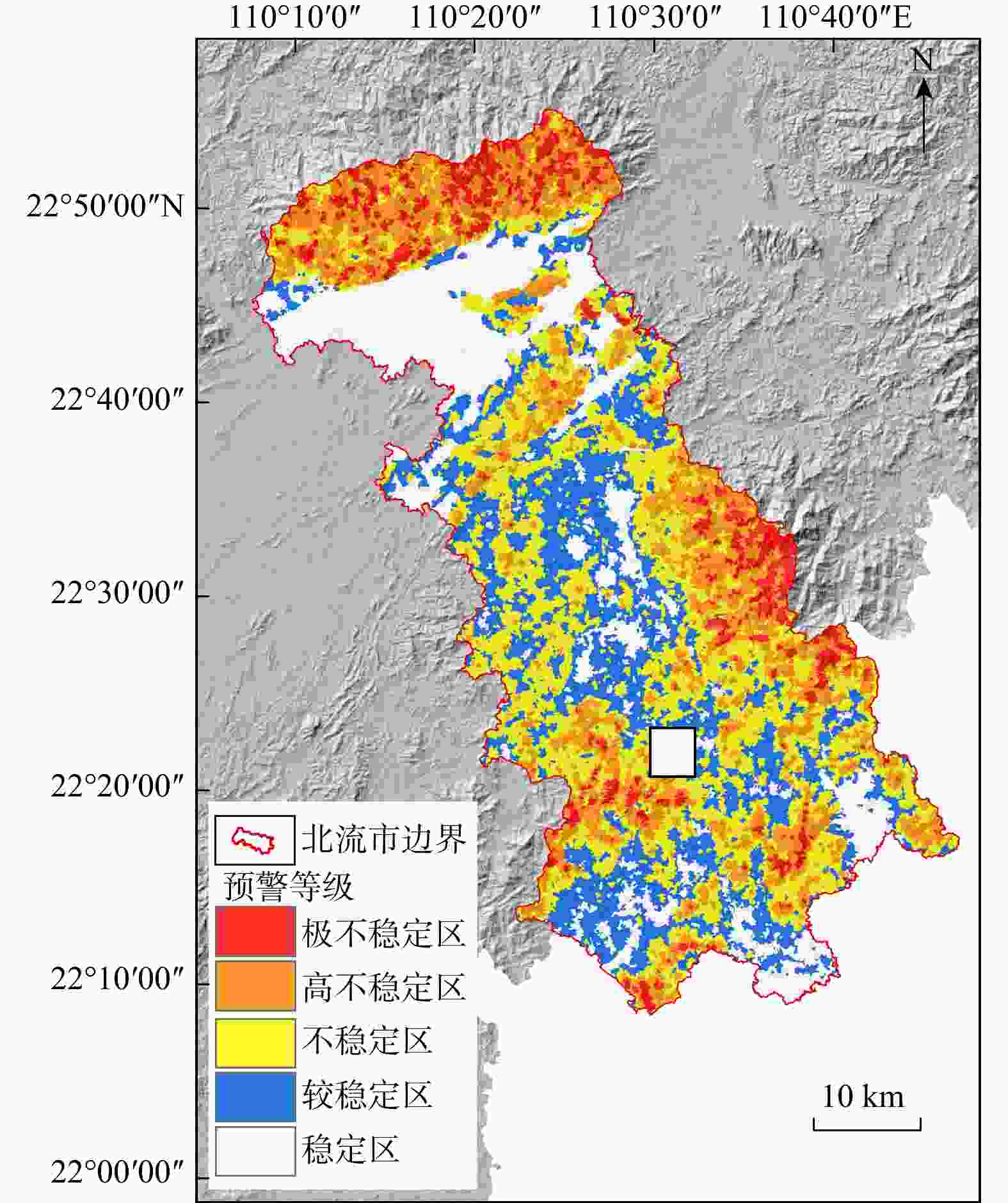
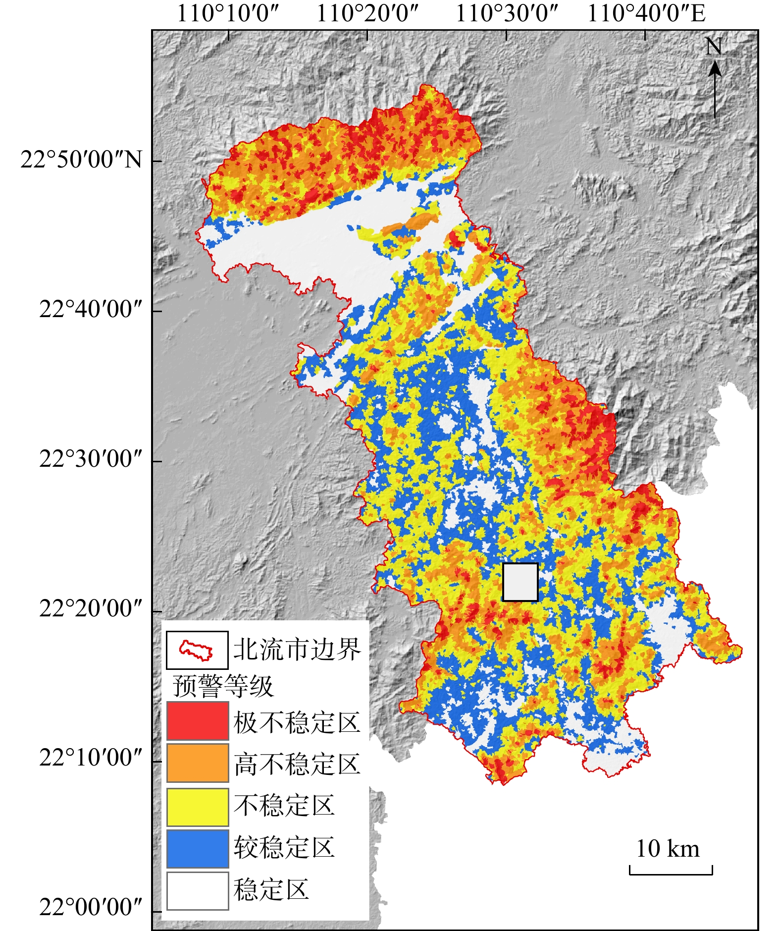
图 9 “6・26”降雨事件下研究区浅层滑坡预警模型
Figure 9. Shallow landslide early warning model in study area under the "6・26" rainfall event
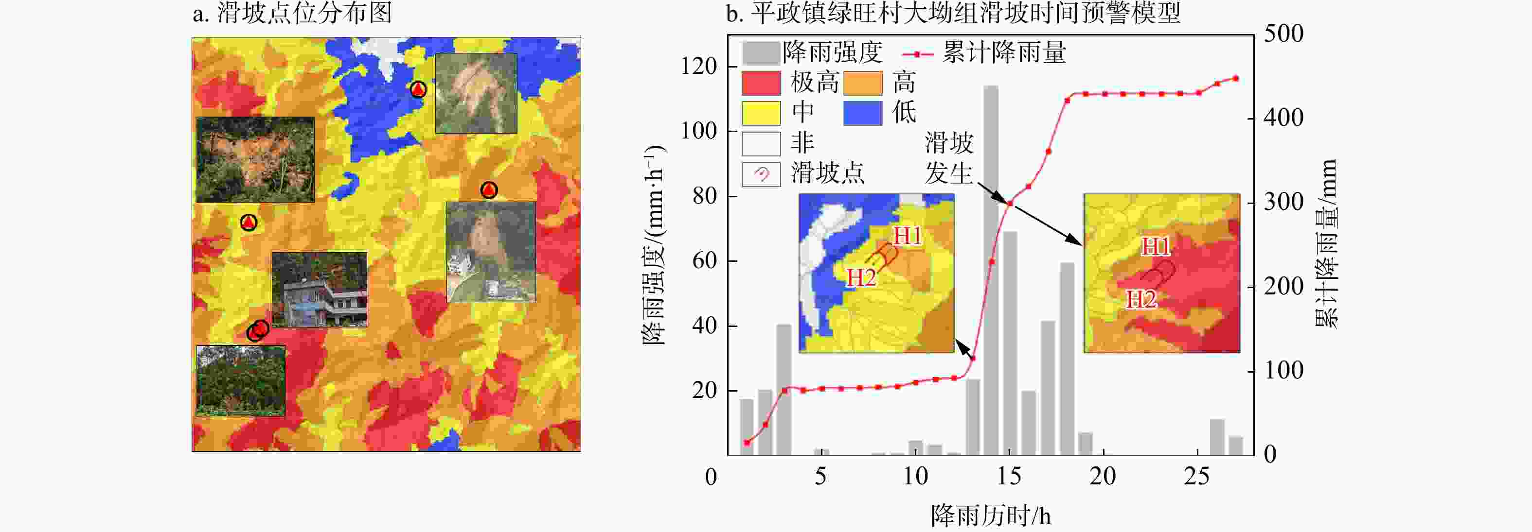
图 10 “6・26”降雨事件下研究区局部滑坡点位分布(a)以及典型滑坡时间预警模型(b)(a图范围见图9;H1,H2均为滑坡编号)
Figure 10. Distribution of local landslide points (a) and typical landslide temporal early warning model (b) in study area under the "6・26" rainfall event
表 1 2021—2023年北流市台风降雨统计
Table 1. Statistics of typhoon-induced rainfall in Beiliu City (2021–2023)
年份 名称编号 日期 距离/km 累计降雨量/mm 2021 2104 小熊2021/06/11—2021/06/13 445 80.60 2021 2107 查帕卡2021/07/17—2021/07/24 过境 269.70 2021 2109卢碧 2021/08/02—2021/08/09 250 691.00 2021 2117 狮子山2021/10/06—2021/10/11 295 158.50 2021 2118 圆规2021/10/08—2021/10/14 400 77.00 2021 2121 雷伊2021/12/12—2021/12/21 404 18.60 2022 2203暹芭 2022/06/29—2022/07/07 过境 487.40 2022 2207 木兰2022/08/08—2022/08/11 279 241.50 2022 2209 马鞍2022/08/21—2022/08/26 115 347.60 2022 2222 尼格2022/10/31—2022/11/03 299 317.50 2023 2304 泰利2023/07/14—2023/07/18 174 268.80 2023 2309 苏拉2023/08/24—2023/09/03 110 596.00 2023 2314 小犬2023/09/30—2023/10/.09 243 90.30 2023 2316 三巴2023/10/17—2023/10/20 156 557.50  下载: 导出CSV
表 2 降雨雨场划分方法
Table 2. Methods for rainfall event classification
詹钱登[35] ①一场连续降雨过程,把小时雨量大于 4 mm 的时刻作为有效降雨开始时间,把小时雨量连续 6 h 均小于 4 mm 的时刻作为有效降雨的结束时间 ②一场连续降雨过程,以前12 h累计降雨量为10 mm的时刻为有效降雨开始时间,而以其后12 h累计降雨量低于10 mm的时刻为有效降雨结束时间 刘美琪[36] ①长历时降雨:以前、后连续24 h无降雨作为一场雨的划分标准 ②中等历时降雨:以前、后连续12 h无降雨作为一场雨的划分标准 ③短历时降雨:在某场降雨过程中,将时段雨量为4 mm作为一场雨的划分标准,即一场连续降雨过程,以时段雨量大于4 mm的时刻为该场次降雨开始时间,以时段雨量连续3 h均小于4 mm的时刻为该场次降雨结束时间
下载: 导出CSV
表 3 时间尺度降雨类型划分标准
Table 3. Classification criteria for rainfall types at time scale
降雨历时T/h ≤24 (24, 72] >72 降雨类型 短历时 中历时 长历时
下载: 导出CSV
表 4 考虑降雨位置参数与偏度的降雨类型划分
Table 4. Classification of rainfall types considering rainfall peak location parameters and skewness
划分依据 S>0.5且
0<R≤0.33−0.5≤S≤0.5且
0.33<R≤0.67S>0.5且
0.67<R≤1降雨类型 前峰型 集中型 后峰型 注:S为降雨偏度;R为降雨峰值位置系数
下载: 导出CSV
表 5 研究区典型台风暴雨事件降雨特征统计
Table 5. Statistics of rainfall characteristics of typical typhoon-induced rainfall events in study area
特征参数 台风“2203暹芭”事件 暴雨+台风“2109卢碧”事件 “6・26”降雨事件 时空范围 北流市南部,历时25 h(强集中) 全境,历时22 d(长持续) 北流市南部+陆川中部,历时26 h 累计降雨量/mm 167.6(南部为主) 691(全域超强累累计) 449.4(降雨强度局部达380.7 mm/24 h) 降雨强度 51.7 mm/h(入境初期) 77 mm/5 h(台风生成前) 114.2 mm/h(突破历史极值) 降雨峰度K −0.34(分布平缓) 6.376(峰值极陡峭) 5.70(极端短时集中) 降雨偏度S 0.77(右偏,后峰型) 2.569(显著右偏,前峰型) 2.31(强右偏,集中型) 降雨峰值位置系数R 0.68(峰值靠后) 0.272(峰值靠前) 0.54(峰值居中,双峰结构) 降雨类型 后峰型 前峰型 集中型 典型区域 新丰镇(南部即时响应) 全域多镇(复合效应) 平政绿旺(极值雨强核心区)
下载: 导出CSV
表 6 降雨参数对滑坡稳定性的物理作用机制
Table 6. Physical mechanisms by which rainfall parameters affect landslide stability
参数 含义 对滑坡稳定性的影响 降雨历时T 降雨持续的总时间 影响土壤饱和程度和入渗累计量,是决定地下水位上升、孔压发展的关键因素。历时越长,潜在滑动面含水量越高,稳定性下降风险越大 降雨峰值位置系数R 降雨峰值在整个历时中所处的位置(R=峰值时刻/T) 用于反映降雨峰值发生的“早晚时机”。R值偏小表示“雨来得快”,入渗尚未完成即迎来强降雨,导致坡体排水不及、孔压突增;R值偏大则影响滑坡的延后响应。影响降雨响应滞后性与风险分布的时间窗口划分 降雨峰度K 降雨曲线的尖锐程度 峰度高说明降雨集中强烈,可能导致瞬时入渗速度远超土壤下渗速率,引发地表径流和孔隙水压力的急剧上升,对滑坡触发的“临界时刻”计算有显著影响 降雨偏度S 曲线的不对称性 决定雨量集中在前段还是后段。偏右(S>0)说明降雨重心在后段,土体积水充分,更可能在降雨后期或停止后引发滑坡,影响模型对滑坡时段的判定精度
下载: 导出CSV
表 7 常用的滑坡稳定性确定性模型
Table 7. Common deterministic models for landslide stability
模型名称 模型介绍及优点 SHALSTA模型 较早将数字地形数据与近地表径流模型及边坡稳定性模型相结合,建立了基于地形的浅层滑坡稳定性模型 SINMAP模型 结合地形湿度指数和考虑根系的土壤内聚力,并考虑了变量的概率分布条件构建浅层滑坡稳定性模型 TRIGRS模型 基于无限边坡模型并结合瞬态入渗理论的稳定性模型,将入渗模块、
水文模块和降雨的径流结合,可以实现区域不同降雨特征的浅层滑坡稳定性模拟Scoops3D模型 综合考虑三维地形、地层条件差异和地下水位条件,建立三维搜索矩阵确定潜在破坏滑动面;能够进行深度滑坡预测 FSLAM模型 由基于无限边坡的岩土模型和地下水模型构成,能够同时考虑地下水横向流和垂直流;模型计算效率高,费时短 PRL-STIM 基于简化瞬态入渗模型的物理驱动型降雨滑坡概率模型
下载: 导出CSV
表 8 TRIGRS-Scoops3D 耦合模型模拟参数
Table 8. Simulation parameters of coupled TRIGRS-Scoops3D model
输入参数 参数范围 参数取值 内摩擦角φ/(°) 19~40 25 黏聚力C/kPa 9~40 27 土壤容重Uws/(kN·m−3) 18.8~19.21 19 饱和容重Us/(kN·m−3) 19.7~20.1 20 部分饱和容重Ur/(kN·m−3) 12 12 饱和含水率$ \theta_{\mathrm{s}} $/% 11~15 12 残余含水率$ \theta_{\mathrm{r}} $/% 7 7 饱和导水率Ks/(m·s−1) 16.8×10⁻⁶ 16.8×10⁻⁶ 扩散率D0/(m·s−1) 16.8×10⁻⁴ 16.8×10⁻⁴ 初始渗透速率Iz/(m·s−1) 3.04×10⁻⁶ 3.04×10⁻⁶ 土壤厚度Z/m 栅格ASCII 栅格ASCII 坡度Slope/(°) 坡度栅格ASCII 坡度栅格ASCII 坡向Aspact/(°) 坡向栅格ASCII 坡向栅格ASCII 流向Direction 流向栅格ASCII 流向栅格ASCII
下载: 导出CSV
表 9 滑坡预警模型划分标准
Table 9. Classification criteria for landslide early warning models
预警分区 极不稳定区 高不稳定区 不稳定区 较稳定区 稳定区 稳定性系数 [0, 0.6) [0.6, 0.8) [0.8, 1.0) [1.0, 1.5] >1.5 预警等级 极高 高 中 低 非 预警颜色 红 橙 黄 蓝 白
下载: 导出CSV
表 10 “6・26”降雨事件下预警模型等级统计
Table 10. Statistics of early warning levels of the prediction model under the "6・26" rainfall event
等级 极高 高 中 低 非 面积/km2 140.55 479.31 706.65 542.20 583.55 斜坡单元数量/个 1802 6145 9060 6951 7482 占比/(%) 5.73 19.55 28.82 22.10 23.80
下载: 导出CSV
-
[1] 孙强, 史绪山, 张泰丽, 等. 基于频率比和Logistic回归耦合模型的台风暴雨型滑坡危险性评价[J]. 应用基础与工程科学学报, 2025, 33(5): 1262-1272. doi: 10.16058/j.issn.1005-0930.2025.05.004SUN Q, SHI X S, ZHANG T L, et al. Hazard assessment of typhoon-triggered landslides based on coupled models of frequency ratio and logistic regression[J]. Journal of Basic Science and Engineering, 2025, 33(5): 1262-1272. (in Chinese with English abstract doi: 10.16058/j.issn.1005-0930.2025.05.004 [2] 栗倩倩, 王伟, 黄亮, 等. 台风暴雨型滑坡滞后效应分析: 以浙江青田县“利奇马”台风为例[J]. 中国地质灾害与防治学报, 2022, 33(6): 10-19. doi: 10.16031/j.cnki.issn.1003-8035.202110018LI Q Q, WANG W, HUANG L, et al. Analysis on lag effect of typhoon-induced landslide: A case study of typhoon "Lekima" in Qingtian County, Zhejiang Province[J]. The Chinese Journal of Geological Hazard and Control, 2022, 33(6): 10-19. (in Chinese with English abstract doi: 10.16031/j.cnki.issn.1003-8035.202110018 [3] 孔雅茜, 陈全明, 陈建华. 湖南资兴“格美”台风群发性地质灾害发育特征及风险管控[J]. 地质灾害与环境保护, 2025, 36(2): 50-55.KONG Y X, CHEN Q M, CHEN J H. Development characteristics and risk control of grouped geological hazards caused by Typhoon Gaemi in Zixing, Hunan Province[J]. Journal of Geological Hazards and Environment Preservation, 2025, 36(2): 50-55. (in Chinese with English abstract [4] 陈涛, 钟子颖, 牛瑞卿, 等. 利用深度信念网络进行滑坡易发性评价[J]. 武汉大学学报(信息科学版), 2020, 45(11): 1809-1817. doi: 10.13203/j.whugis20190144CHEN T, ZHONG Z Y, NIU R Q, et al. Mapping landslide susceptibility based on deep belief network[J]. Geomatics and Information Science of Wuhan University, 2020, 45(11): 1809-1817. (in Chinese with English abstract doi: 10.13203/j.whugis20190144 [5] 许强, 陆会燕, 李为乐, 等. 滑坡隐患类型与对应识别方法[J]. 武汉大学学报(信息科学版), 2022, 47(3): 377-387. doi: 10.13203/j.whugis20210618XU Q, LU H Y, LI W L, et al. Types and corresponding identification methods of landslide hazards[J]. Geomatics and Information Science of Wuhan University, 2022, 47(3): 377-387. (in Chinese with English abstract doi: 10.13203/j.whugis20210618 [6] 李林锐. 基于降雨入渗/超孔隙水压力的Newmark模型改进及地震滑坡危险性预测研究[D]. 昆明: 云南大学, 2022.LI L R. Study on the improvement of Newmark model and seismic landslide risk prediction based on rainfall infiltration/excess pore water pressure[D]. Kunming: Yunnan University, 2022. (in Chinese with English abstract [7] JIA N, MITANI Y, XIE M W, et al. GIS deterministic model-based 3D large-scale artificial slope stability analysis along a highway using a new slope unit division method[J]. Natural Hazards, 2015, 76(2): 873-890. doi: 10.1007/s11069-014-1524-6 [8] MEISINA C, SCARABELLI S. A comparative analysis of terrain stability models for predicting shallow landslides in colluvial soils[J]. Geomorphology, 2007, 87(3): 207-223. doi: 10.1016/j.geomorph.2006.03.039 [9] ZHENG Y X, HU Z P, WANG R, et al. Modified Green-Ampt model for infiltration analysis in loess area and its parameter determination and verification[J]. Scientific Reports, 2025, 15: 1738. doi: 10.1038/s41598-025-86175-9 [10] 胡庆, 吴益平, 苗发盛, 等. 基于Mein-Larson入渗模型的凹形边坡稳定性分析[J]. 中国地质灾害与防治学报, 2021, 32(6): 26-35.HU Q, WU Y P, MIAO F S, et al. Stability analysis of concave slope based on Mein-Larson infiltration model[J]. The Chinese Journal of Geological Hazard and Prevention, 2021, 32(6): 26-35. (in Chinese with English abstract [11] DO PINHO T M, AUGUSTO FILHO O. Landslide susceptibility mapping using the infinite slope, SHALSTAB, SINMAP, and TRIGRS models in Serra do Mar, Brazil[J]. Journal of Mountain Science, 2022, 19(4): 1018-1036. doi: 10.1007/s11629-021-7057-z [12] PACK R T, TARBOTON D G, GOODWIN C N, et al. SINMAP 2.0 for ArcGIS: A stability index approach to terrain stability hazard mapping[R]. Logan: Utah State University, 2005. [13] BAUM R L, SAVAGE W Z, GODT J W. TRIGRS: A Fortran program for transient rainfall infiltrationand grid-based regional slope-stability analysis, version 2.0[R]. Reston: U. S. Geological Survey, 2008. [14] TERHORST B, KREJA R. Slope stability modelling with SINMAP in a settlement area of the Swabian Alb[J]. Landslides, 2009, 6(4): 309-319. doi: 10.1007/s10346-009-0167-2 [15] 简文星, 许强, 童龙云. 三峡库区黄土坡滑坡降雨入渗模型研究[J]. 岩土力学, 2013, 34(12): 3527-3533.JIAN W X, XU Q, TONG L Y. Rainfall infiltration model of Huangtupo landslide in Three Gorges Reservoir area[J]. Rock and Soil Mechanics, 2013, 34(12): 3527-3533. (in Chinese with English abstract [16] 李秀珍, 何思明, 王震宇, 等. 降雨入渗诱发斜坡失稳的物理模型适用性分析[J]. 灾害学, 2015, 30(1): 34-38.LI X Z, HE S M, WANG Z Y, et al. Applicability analysis on physical models of slope instability induced by rainfall infiltration[J]. Journal of Catastrophology, 2015, 30(1): 34-38. (in Chinese with English abstract [17] 常志璐, 黄发明, 蒋水华, 等. 基于多尺度分割方法的斜坡单元划分及滑坡易发性预测[J]. 工程科学与技术, 2023, 55(1): 184-195.CHANG Z L, HUANG F M, JIANG S H, et al. Slope unit extraction and landslide susceptibility prediction using multi-scale segmentation method[J]. Advanced Engineering Sciences, 2023, 55(1): 184-195. (in Chinese with English abstract [18] 唐扬, 殷坤龙, 汪洋, 等. 斜坡降雨入渗的改进Mein-Larson模型[J]. 地球科学, 2017, 42(4): 634-640.TANG Y, YIN K L, WANG Y, et al. The landslide rain infiltration based on the improved Mein-Larson model[J]. Earth Science, 2017, 42(4): 634-640. (in Chinese with English abstract [19] 陈悦丽, 陈德辉, 李泽椿, 等. 基于 Monte Carlo-SHALSTAB 模型的滑坡危险性评价: 以福建省德化县为例[J]. 灾害学, 2015, 30(4): 101-106.CHEN Y L, CHEN D H, LI Z C, et al. Assessment of landslide hazard based on Monte Carlo-SHALSTAB model[J]. Journal of Catastrophology, 2015, 30(4): 101-106. (in Chinese with English abstract [20] QIU H J, ZHU Y R, ZHOU W Q, et al. Influence of DEM resolution on landslide simulation performance based on the Scoops3D model[J]. Geomatics, Natural Hazards and Risk, 2022, 13(1): 1663-1681. doi: 10.1080/19475705.2022.2097451 [21] 姚志永. 基于SINMAP和TRIGRS模型的辰溪县暴雨型浅层滑坡易发性评价研究[D]. 北京: 中国地质大学(北京), 2018.YAO Z Y. Susceptibility assessment of shallow landslides in Chenxi County based on SINMAP and TRIGRS models[D]. Beijing: China University of Geosciences(Beijing), 2018. (in Chinese with English abstract [22] 何简吟. 降雨型浅层滑坡稳定性研究: 基于TRIGRS模型和Scoops3D模型[D]. 西安: 西北大学, 2021.HE J Y. Stability analysis of rainfall-induced shallow landslide: Based on TRIGRS model and Scoops3D model[D]. Xi'an: Northwest University, 2021. (in Chinese with English abstract [23] 孙何生. 基于Scoops3D模型的青藏高原东北缘斜坡稳定性评价: 以甲加沟为例[D]. 西安: 西北大学, 2022.SUN H S. Evaluation of slope stability in northeastern margin of Tibetan Plateau based on Scoops3D model: A case study of Jiajiagou[D]. Xi'an: Northwest University, 2022. (in Chinese with English abstract [24] CAINE N. The rainfall intensity: Duration control of shallow landslides and debris flows[J]. Geografiska Annaler Series A, Physical Geography, 1980, 62(1/2): 23-27. [25] GODT J W, BAUM R L, CHLEBORAD A F. Rainfall characteristics for shallow landsliding in Seattle, Washington, USA[J]. Earth Surface Processes and Landforms, 2006, 31(1): 97-110. doi: 10.1002/esp.1237 [26] HE S S, WANG J, LIU S N. Rainfall event-duration thresholds for landslide occurrences in China[J]. Water, 2020, 12(2): 494. doi: 10.3390/w12020494 [27] 龚泉冰, 殷坤龙, 肖常贵, 等. 基于I-D阈值的滑坡气象预警双指标模型[J]. 地质科技通报, 2024, 43(1): 262-274. doi: 10.19509/j.cnki.dzkq.tb20220254GONG Q B, YIN K L, XIAO C G, et al. Double-index model of landslide meteorological warning based on the I-D threshold[J]. Bulletin of Geological Science and Technology, 2024, 43(1): 262-274. (in Chinese with English abstract doi: 10.19509/j.cnki.dzkq.tb20220254 [28] 刘传正, 刘艳辉, 温铭生, 等. 中国地质灾害气象预警实践: 2003—2012[J]. 中国地质灾害与防治学报, 2015, 26(1): 1-8.LIU C Z, LIU Y H, WEN M S, et al. Early warning for regional geo-hazards during 2003-2012, China[J]. The Chinese Journal of Geological Hazard and Control, 2015, 26(1): 1-8. (in Chinese with English abstract [29] 刘艳辉, 方然可, 苏永超, 等. 基于机器学习的区域滑坡灾害预警模型研究[J]. 工程地质学报, 2021, 29(1): 116-124.LIU Y H, FANG R K, SU Y C, et al. Research on regional landslide disaster early warning model based on machine learning[J]. Journal of Engineering Geology, 2021, 29(1): 116-124. (in Chinese with English abstract [30] 翟淑花, 于家烁, 齐干, 等. 降雨入渗条件下堆积体边坡致灾因子试验分析[J]. 地质科技通报, 2023, 42(3): 9-15. doi: 10.19509/j.cnki.dzkq.tb20220488ZHAI S H, YU J S, QI G, et al. Experimental analysis of disaster-causing factors in accumulated slopes under rainfall infiltration conditions[J]. Bulletin of Geological Science and Technology, 2023, 42(3): 9-15. (in Chinese with English abstract doi: 10.19509/j.cnki.dzkq.tb20220488 [31] ZHAO B R, DAI Q, HAN D W, et al. Estimation of soil moisture using modified antecedent precipitation index with application in landslide predictions[J]. Landslides, 2019, 16(12): 2381-2393. doi: 10.1007/s10346-019-01255-y [32] WU Y, LU G Y, ZHU Z Q, et al. A landslide warning method based on K-means-ResNet fast classification model[J]. Applied Sciences, 2023, 13(1): 459. [33] 周立荣. 红层边坡浅层破坏机理及生态防护技术[D]. 成都: 西南交通大学, 2011.ZHOU L R. Study on shallow layer failure mechanism and ecological protection of red bed slope[D]. Chengdu: Southwest Jiaotong University, 2011. (in Chinese with English abstract [34] 李越飞. 浅层黄土滑坡的形成与运动机理研究: 以延长县为例[D]. 西安: 长安大学, 2018.LI Y F. Study on formation and motion mechanism of shallow loess landslide: Taking Yanchang County as the study area[D]. Xi'an: Changan University, 2018. (in Chinese with English abstract [35] 詹钱登. 降雨及地文条件与土石流发生关系之研究[D]. 台湾台南: 国立成功大学, 2003.ZHAN Q D. Study on the relationship between rainfall and geomorphic conditions and the occurrence of debris flow[D]. Tainan Taiwan: National Cheng Kung University, 2003. (in Chinese with English abstract [36] 刘美琪. 基于特征雨型的山洪灾害雨量预警模式研究[D]. 郑州: 郑州大学, 2019.LIU M Q. Study on rainfall early warning model of mountain flash flood based on characteristic rainfall patterns[D]. Zhengzhou: Zhengzhou University, 2019. (in Chinese with English abstract [37] FAN L F, LEHMANN P, ZHENG C M, et al. Rainfall intensity temporal patterns affect shallow landslide triggering and hazard evolution[J]. Geophysical Research Letters, 2020, 47(1): e2019GL085994. doi: 10.1029/2019GL085994 [38] VIEIRA B C, FERNANDES N F, AUGUSTO FILHO O, et al. Assessing shallow landslide hazards using the TRIGRS and SHALSTAB models, Serra do Mar, Brazil[J]. Environmental Earth Sciences, 2018, 77(6): 260. doi: 10.1007/s12665-018-7436-0 [39] ZHANG S, WANG F W. Three-dimensional seismic slope stability assessment with the application of Scoops3D and GIS: A case study in Atsuma, Hokkaido[J]. Geoenvironmental Disasters, 2019, 6(1): 9. doi: 10.1186/s40677-019-0125-9 [40] MA S Y, SHAO X Y, XU C. Physically-based rainfall-induced landslide thresholds for the Tianshui area of Loess Plateau, China by TRIGRS model[J]. Catena, 2023, 233: 107499. doi: 10.1016/j.catena.2023.107499 [41] REID M E, CHRISTIAN S B, BRIEN D L, et al. Scoops3D: Software to analyze three-dimensional slope stability throughout a digital landscape[R]. US Geological Survey Techniques and Methods: Book, 2015. [42] 郭子正. 区域浅层滑坡危险性的评价模型研究及其应用[D]. 武汉: 中国地质大学(武汉), 2021.GUO Z Z. A hazard assessment model for regional shallow landslide and its application[D]. Wuhan: China University of Geosciences(Wuhan), 2021. (in Chinese with English abstract [43] 姬建, 崔红志, 佟斌, 等. 基于物理过程不确定性的降雨诱发浅层滑坡易发性快速区划: GIS-FORM技术开发与应用[J]. 岩石力学与工程学报, 2024, 43(4): 838-850. doi: 10.13722/j.cnki.jrme.2023.0724JI J, CUI H Z, TONG B, et al. Fast zoning of rainfall-induced shallow landslide susceptibility based on physical process uncertainty: Development and application of GIS-FORM[J]. Chinese Journal of Rock Mechanics and Engineering, 2024, 43(4): 838-850. (in Chinese with English abstract doi: 10.13722/j.cnki.jrme.2023.0724 -

 下载:
下载:


 点击查看大图

计量
- 文章访问数: 201
- PDF下载量: 12
- 被引次数: 0

