
 投审稿入口
投审稿入口

Development characteristics and controlling factors of landslides triggered by extreme rainfall on April 20, 2024 in Shaoguan City, Guangdong Province
-
摘要:
2024年4月20日,广东省韶关市发生了特大暴雨事件,韶关市江湾镇地区24 h降雨量达到历史极值206 mm,诱发大规模滑坡,导致多地居民房屋遭到损毁、道路中断,引起了社会的广泛关注。及时获取降雨诱发滑坡编目、发育分布规律及主要调控因子对灾后的应急救援决策和恢复重建至关重要。基于Planet高分辨率遥感影像,采用归一化植被指数(normalized difference vegetation index,简称NDVI)差分法自动提取滑坡区域,并绘制滑坡清单。同时,结合地形、降雨和地质环境因素,分析了滑坡分布规律及其成因。此次极端降雨共诱发滑坡
1426 处,总面积4.56 km2,规模以中小型滑坡为主,主要沿河流呈EN-WS向聚集,形成带状分布,群发性效应显著。空间统计分析显示,滑坡主要集中分布在海拔200~300 m、坡度为20°~30°的斜坡区域。进一步采用逻辑回归、支持向量机、随机森林和极限梯度提升4种机器学习模型,评估降雨诱发滑坡易发性制图精度。结果表明,随机森林和极限梯度提升模型性能最佳,易发区主要分布在河谷两侧的山体斜坡区域。通过SHAP(SHapley additive exPlanations)方法量化分析滑坡的主控因子,发现海拔、降雨量、剖面曲率和地形湿度指数是滑坡发生的关键驱动因素。该研究可为降雨诱发滑坡的快速识别及基于深度学习的易发性评价提供有效方法与数据支持。Abstract:ObjectiveOn April 20, 2024, an extreme rainstorm event occurred in Shaoguan City, Guangdong Province, South China. The 24-hour rainfall in Jiangwan Town reached a historical maximum value of 206 mm, which triggered a large number of landslides. These hazards caused serious damage to residential buildings, road blockages, and widespread social concern. Timely acquisition of landslide inventories, understanding their development distribution patterns, and identifying main controlling factors are crucial for post-disaster emergency response and reconstruction.
MethodsBased on high-resolution Planet remote sensing images, the normalized difference vegetation index (NDVI) difference method combined with terrain correction and morphological post-processing was adopted to automatically extract landslide areas. A complete landslide inventory was compiled. Meanwhile, the spatial distribution patterns and causal factors of the landslides were analyzed, combined with topographic, rainfall, and geological environmental factors. The SHapley additive exPlanations (SHAP) method was applied to quantitatively identify the dominant controlling factors of landslide occurrence.
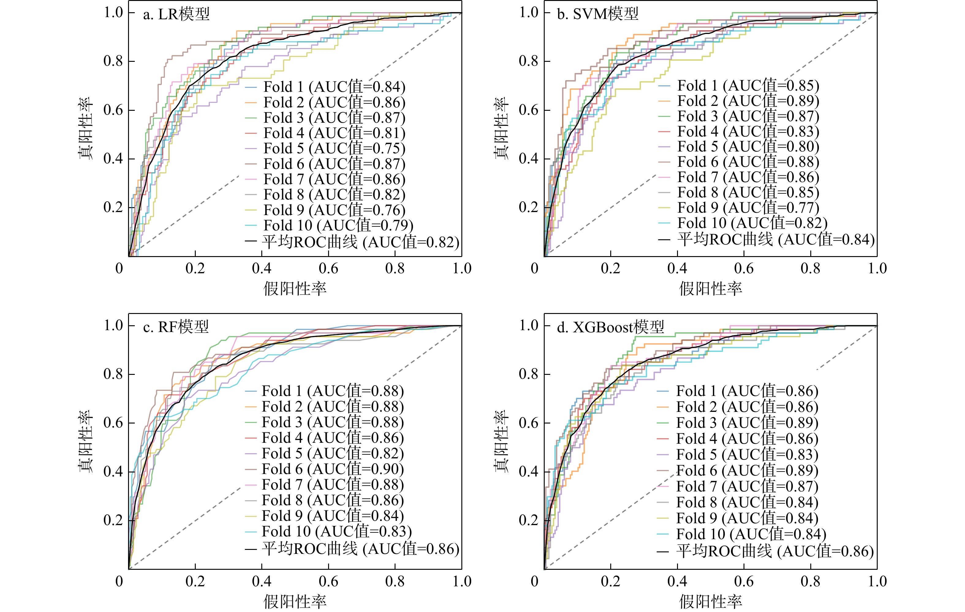
ResultsThe results showed that the extreme rainfall event triggered 1 426 landslides in total, with a total area of 4.56 km2, mainly small to medium scale in size. Landslides predominantly clustered along rivers in a Northeast-Southwest orientation, forming belt-like distributions, with notable group-occurring effects. Spatial statistical analysis revealed that landslides were intensively distributed in slope areas with elevations of 200-300 m and slopes of 20°-30°. Four machine learning models, namely logistic regression (LR), support vector machine (SVM), random forest (RF), and eXtreme gradient boosting (XGBoost), were used to evaluate the accuracy of landslide susceptibility mapping. The results showed that random forest and eXtreme gradient boosting models performed best, identifying highly susceptible areas mainly on mountain slopes on both sides of the river valleys. Through quantitative analysis of the main controlling factors of landslides using the SHAP method, it was found that elevation, rainfall, profile curvature, and topographic wetness index (TWI) were the key driving factors for landslide occurrence.
ConclusionThis study provides reliable technical approaches, refined data support, and practical reference for rapid identification of rainfall-induced group-occurring landslides and machine learning-based susceptibility evaluation in similar mountainous areas.
-
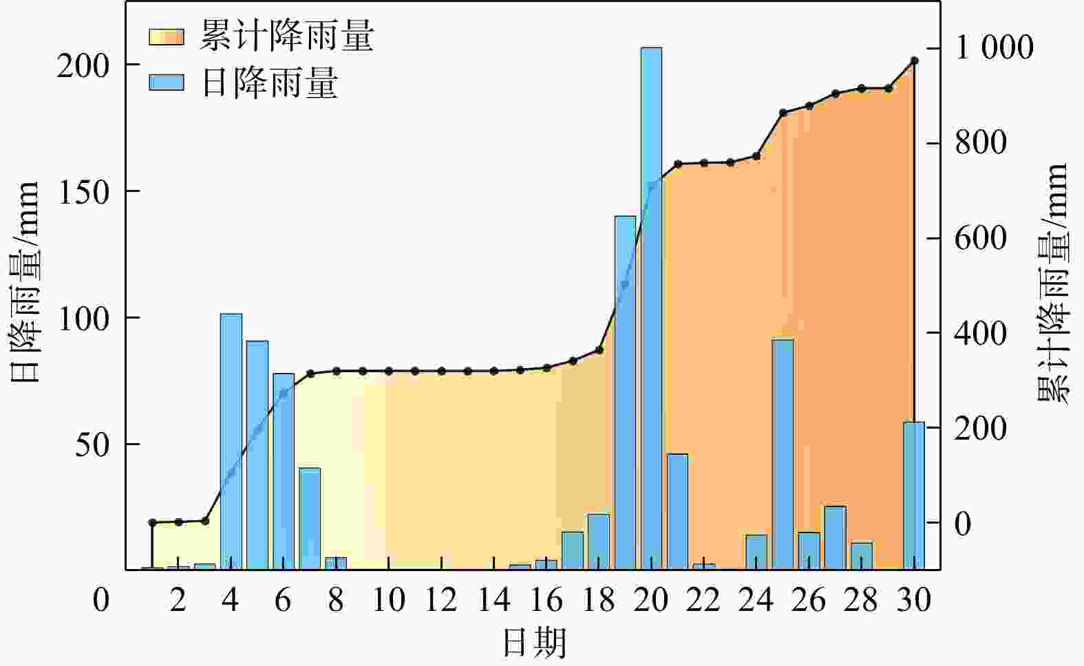
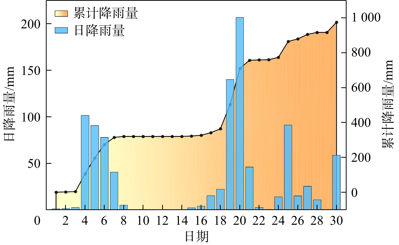
图 3 韶关市气象站点记录的2024年4月降雨量数据
Figure 3. Rainfall data recorded by meteorological stations of Shaoguan City at April, 2024
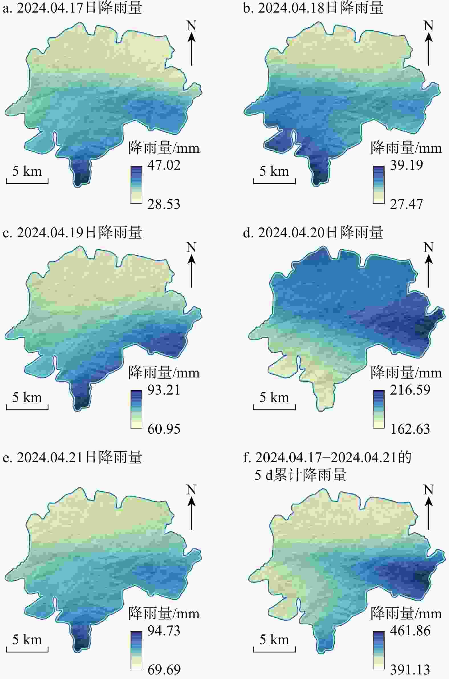
图 4 江湾镇2024年4月17−21日降雨量分布
Figure 4. Rainfall distribution of Jiangwan Town from April 17 to 21, 2024
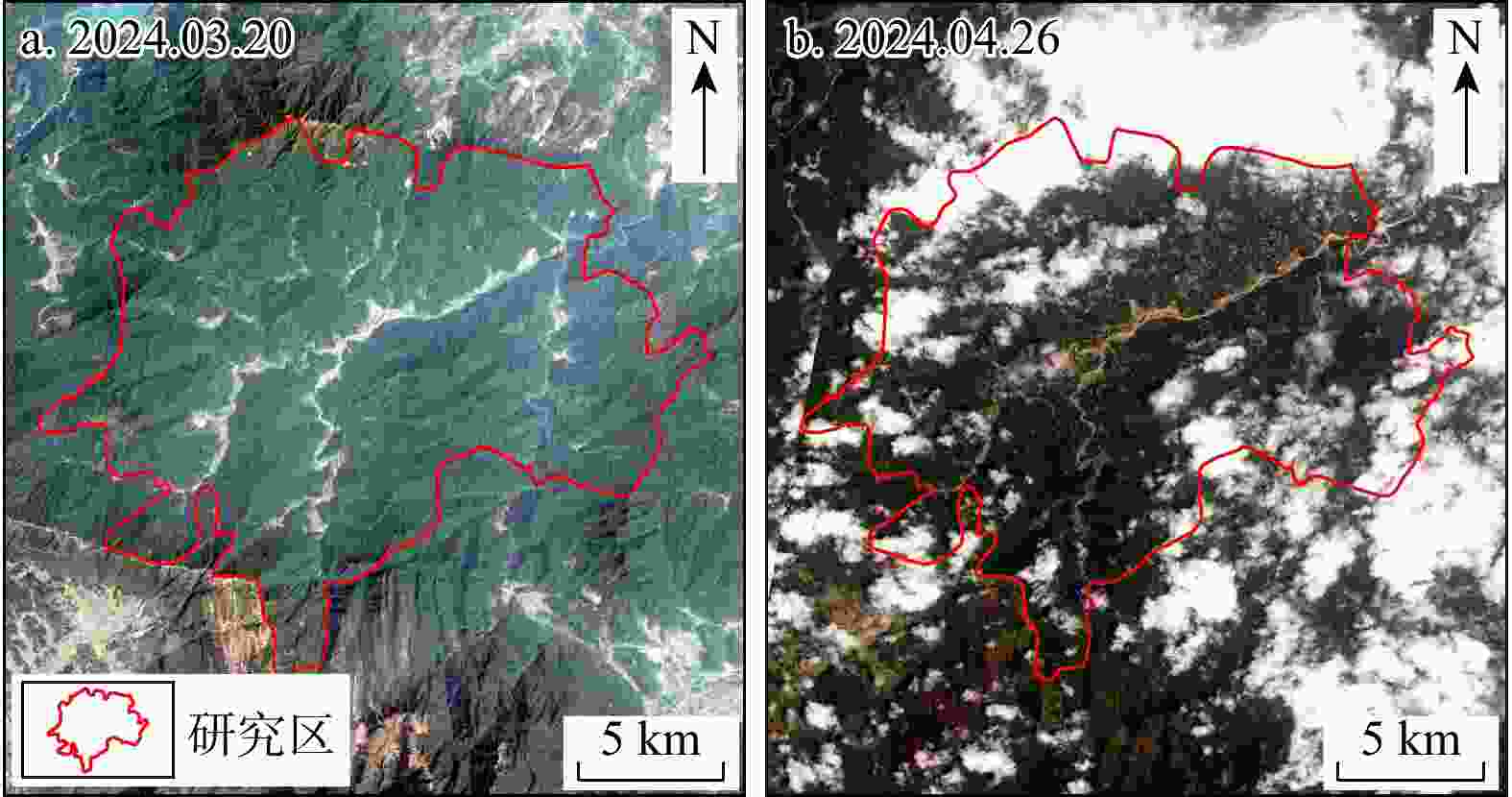
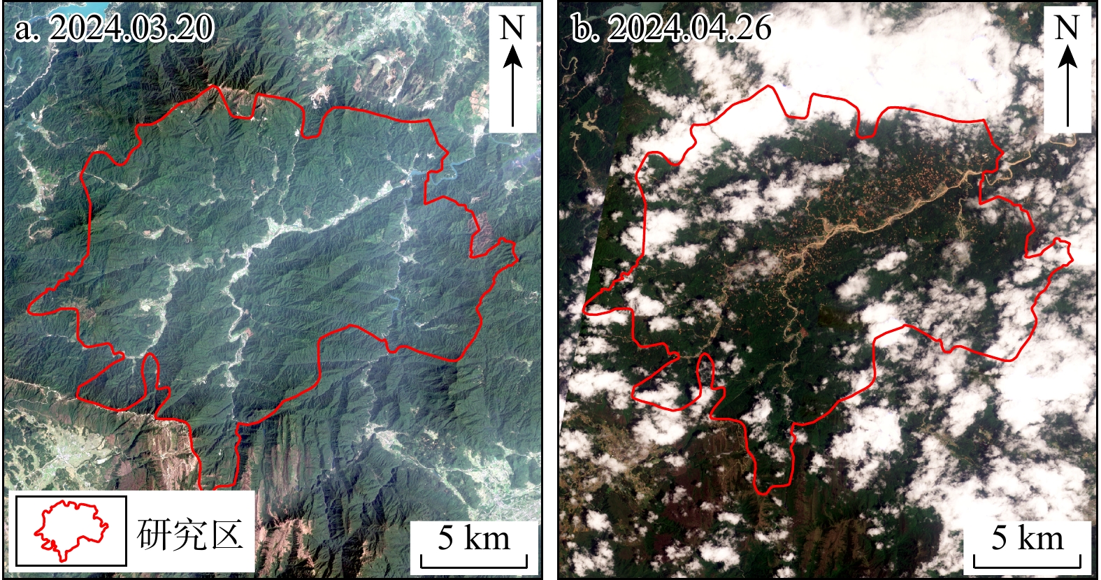
图 5 江湾镇降雨事件前(a)后(b)的Planet卫星影像
Figure 5. Planet satellite imagery before (a) and after (b) a rainfall event of Jiangwan Town
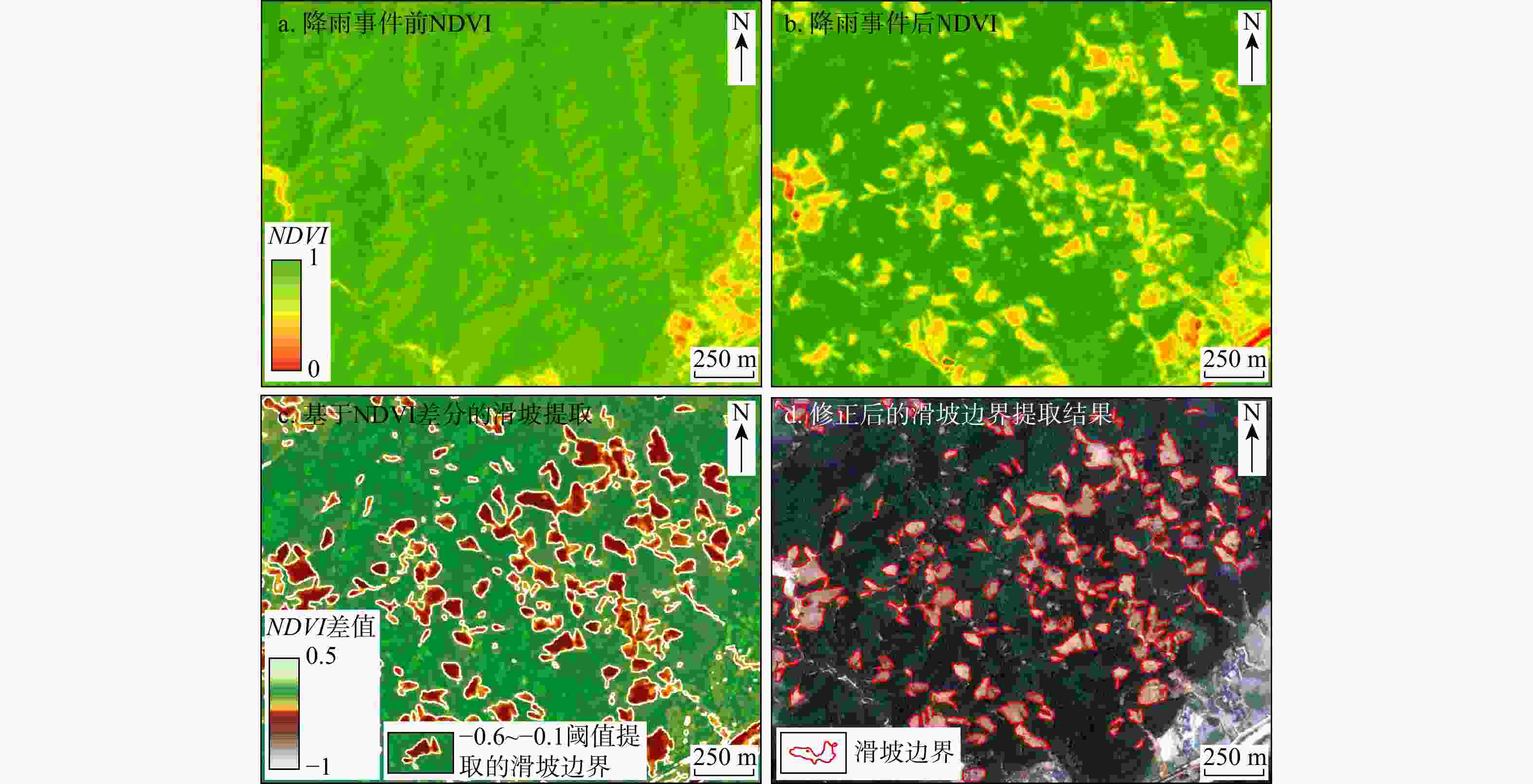
图 6 基于归一化植被指数(NDVI)差分的滑坡检测方法流程
Figure 6. Flow of NDVI difference-based landslide detection method
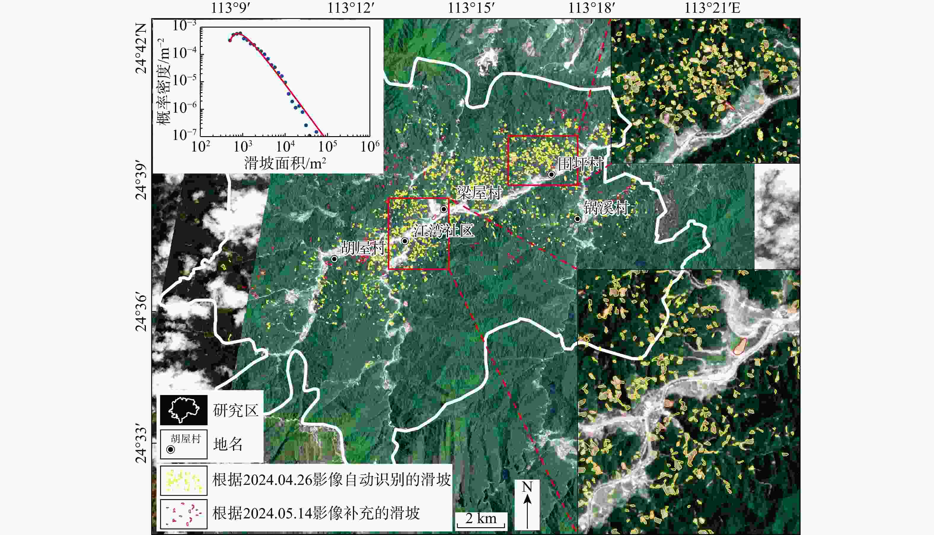
图 7 韶关市江湾镇2024年“4·20”极端降雨诱发滑坡清单
Figure 7. Inventory of landslides triggered by extreme rainfall event at April 20, 2024, in Jiangwan Town, Shaoguan City
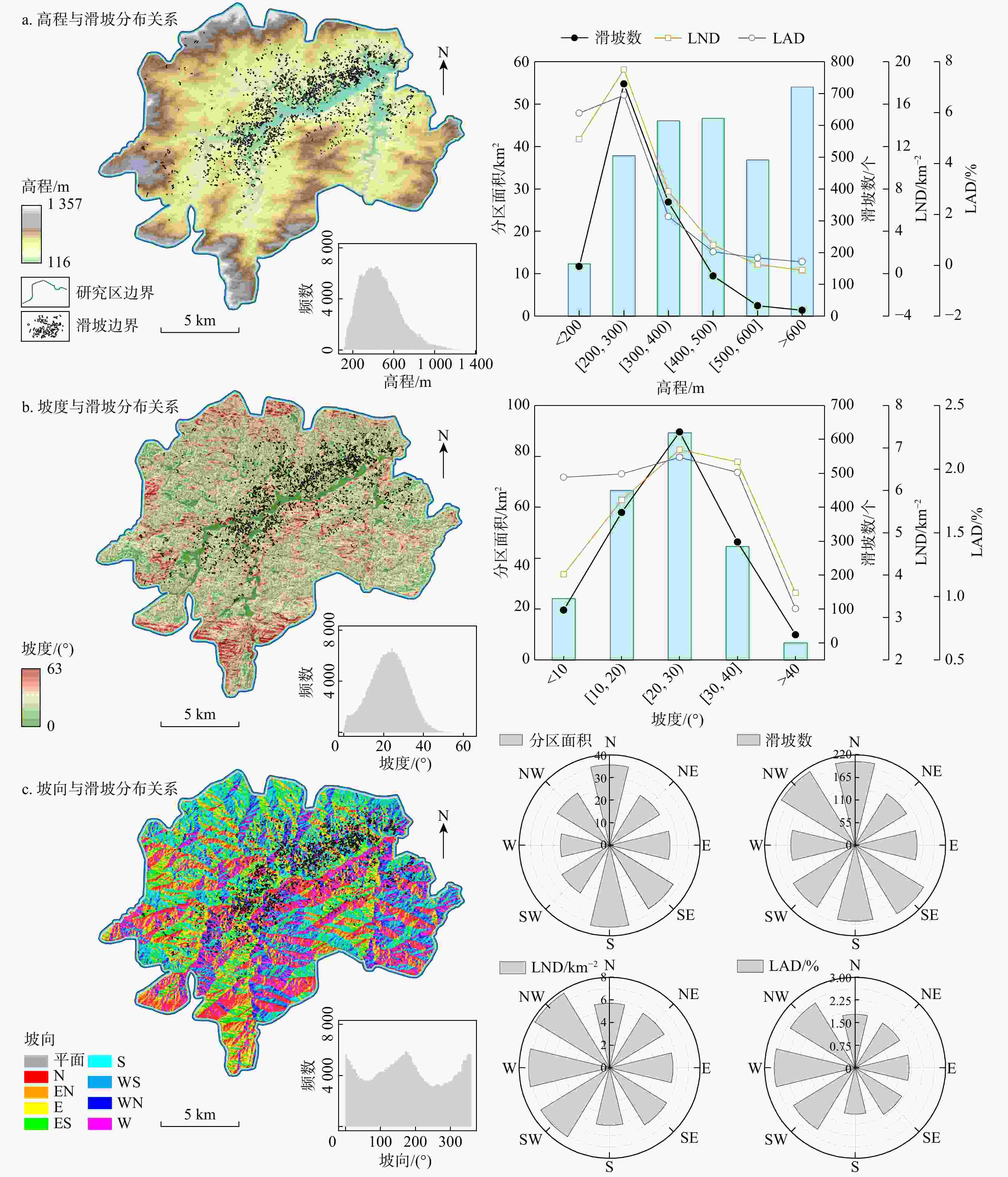
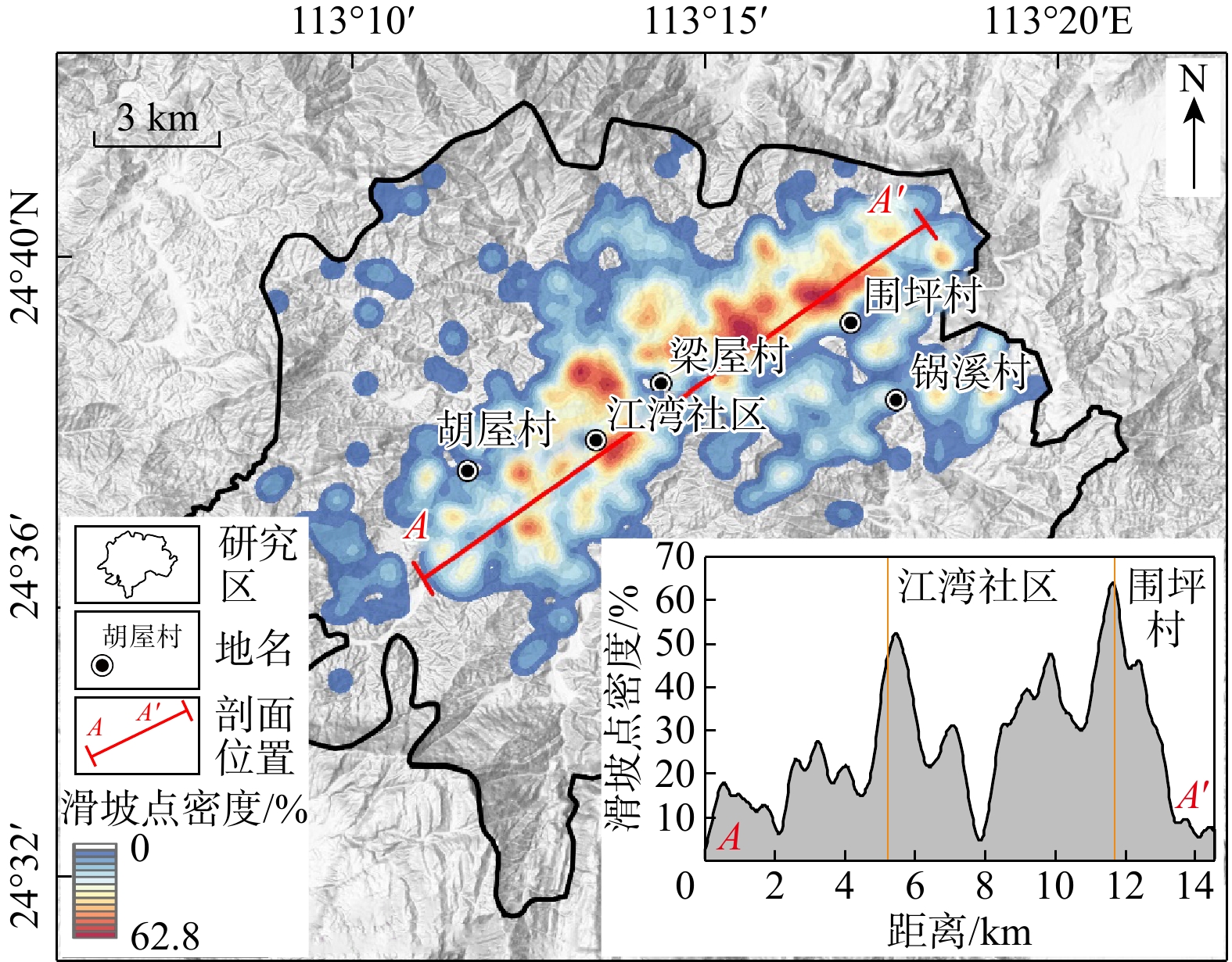
图 9 研究区地形因子与滑坡分布关系(LND. 滑坡密度;LAD. 滑坡面积密度;下同)
Figure 9. Relationship between topographic factors and landslide distribution in the study area
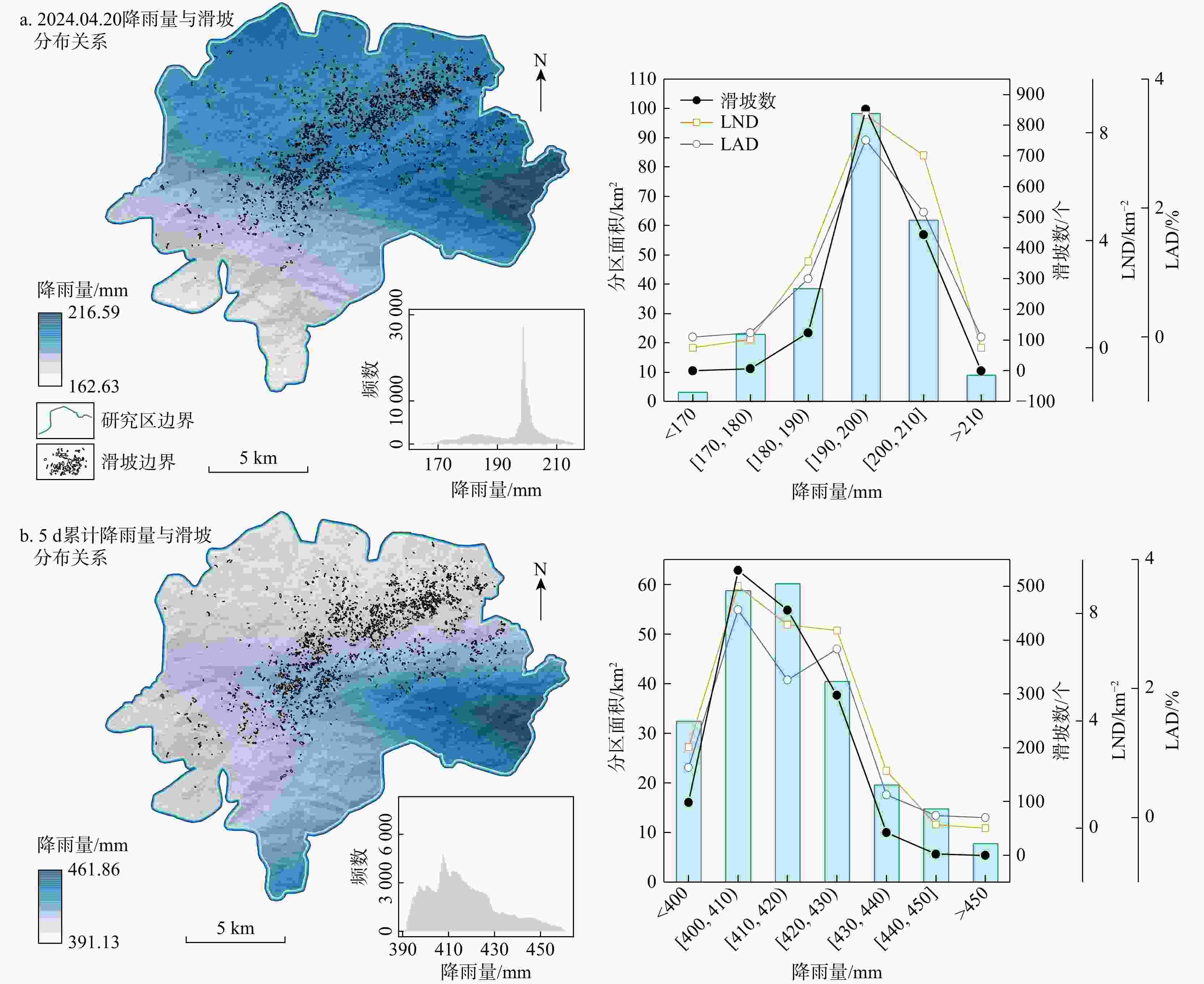
图 10 研究区降雨量与滑坡分布关系
Figure 10. Relationship between rainfall and landslide distribution in the study area
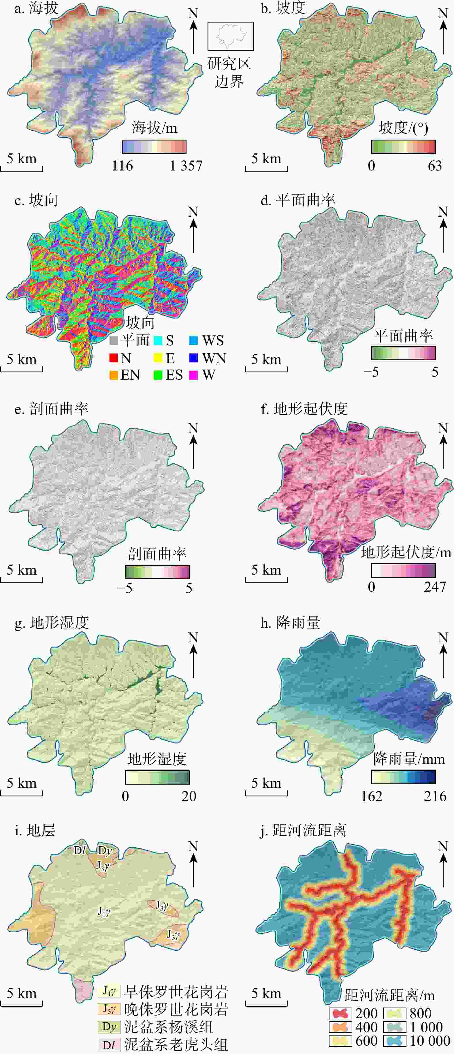
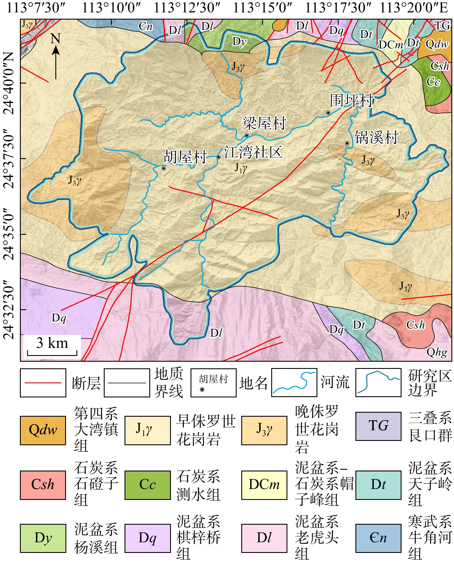
图 11 研究区滑坡易发性评价因子
Figure 11. Landslide susceptibility evaluation factors in the study area
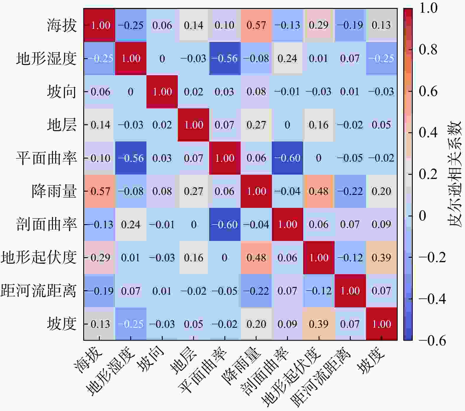
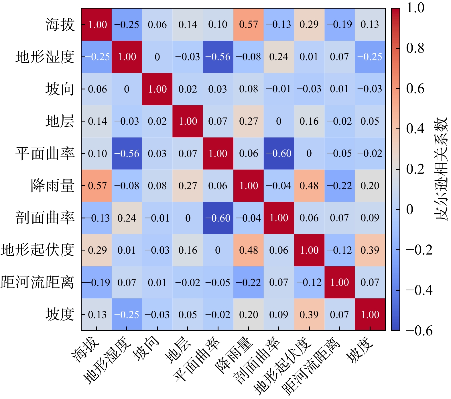
图 12 研究区滑坡易发性评价因子间的皮尔逊相关系数
Figure 12. Pearson correlation coefficients among evaluation factors of landslide susceptibility in the study area
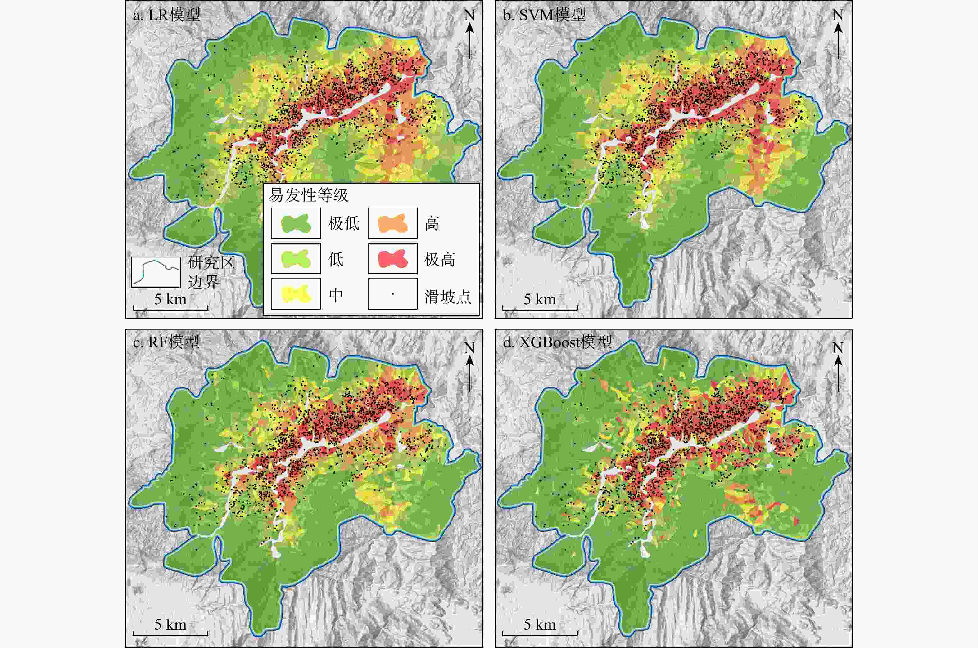
图 13 研究区使用4种模型绘制的研究区滑坡易发性地图
Figure 13. Landslide susceptibility maps generated using four different models in the study area
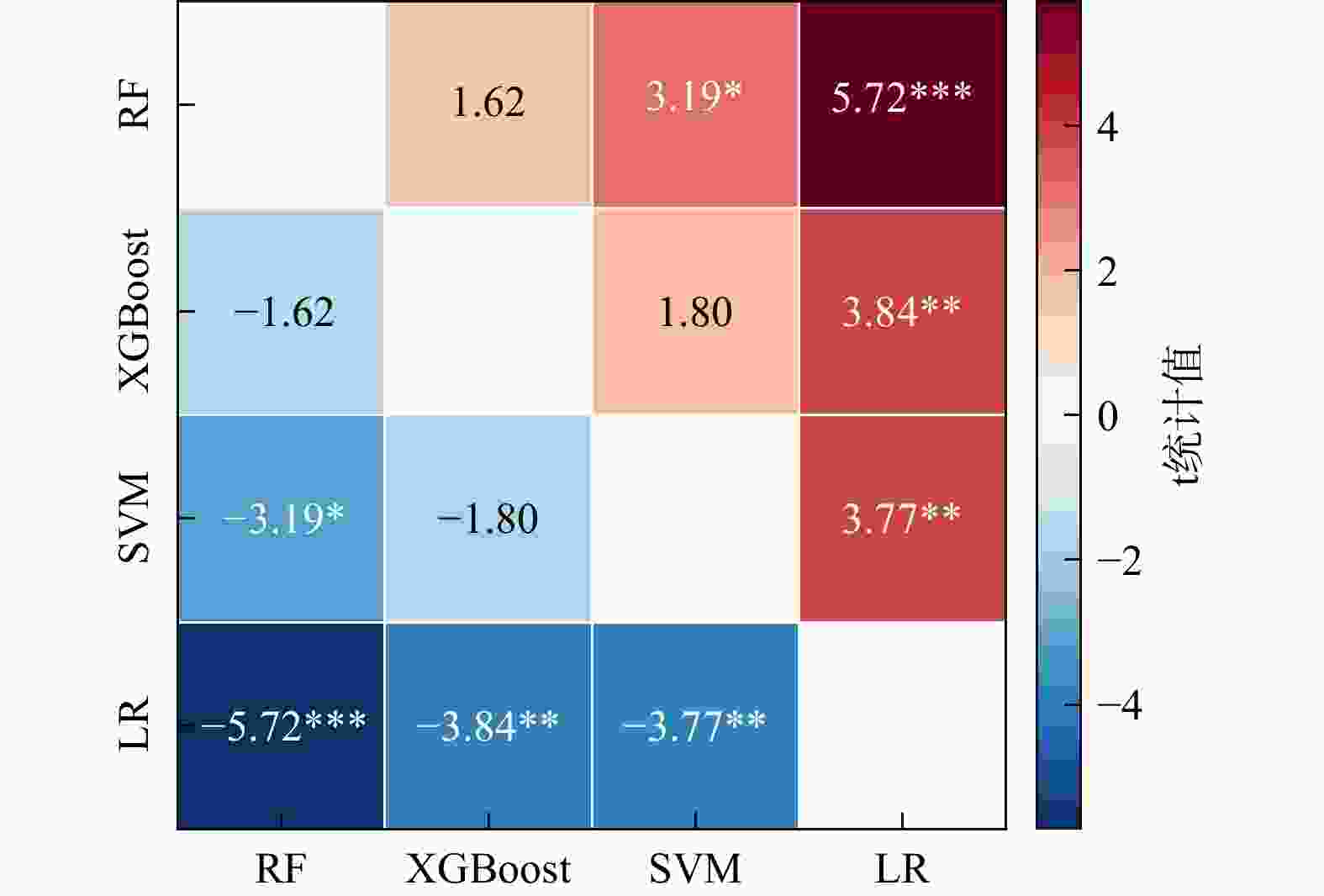
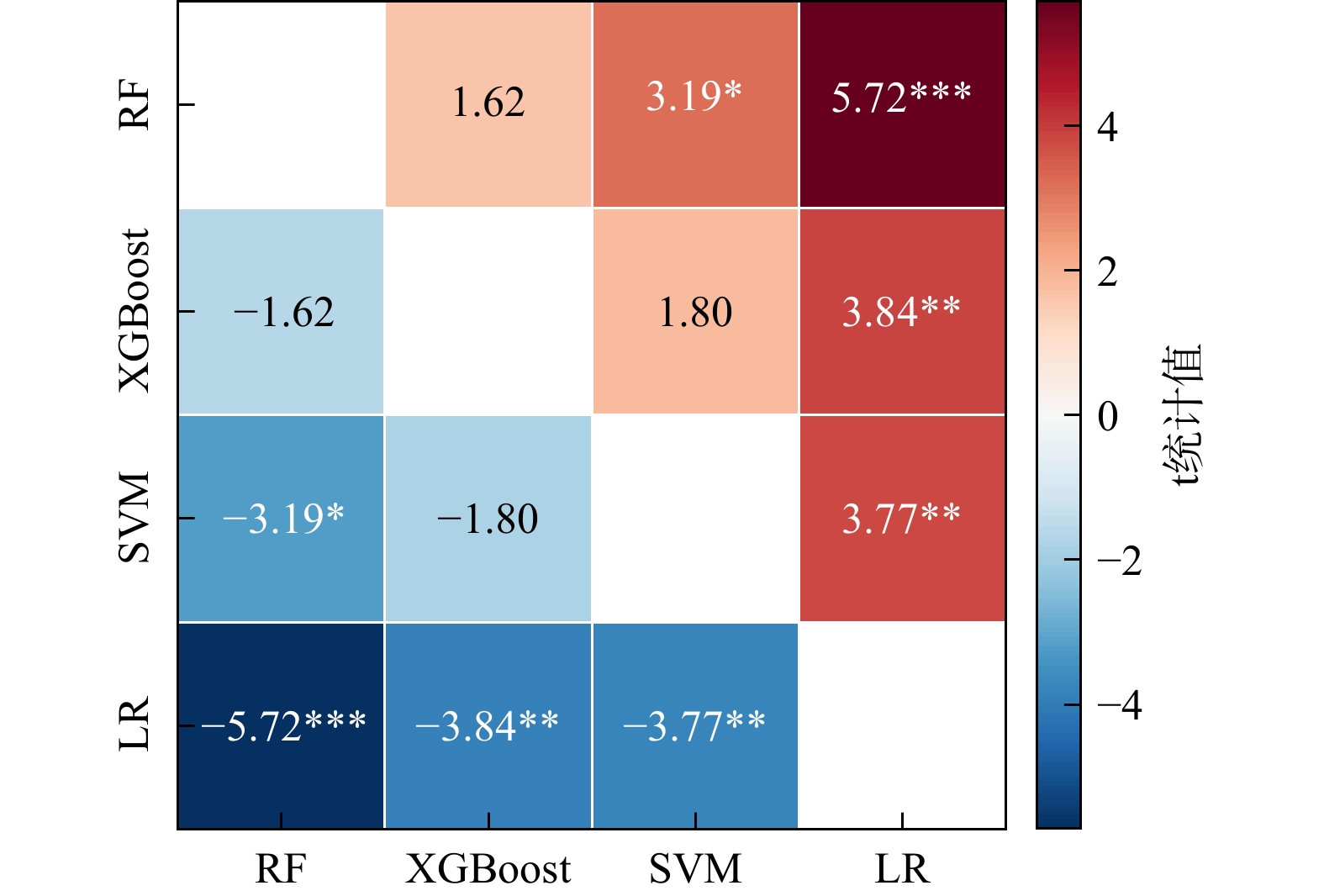
图 15 不同模型AUC值的配对t检验结果
注:* 表示显著性系数p<0.05;** 表示p<0.01;*** 表示p<0.001
Figure 15. Paired t-test results of AUC for different models
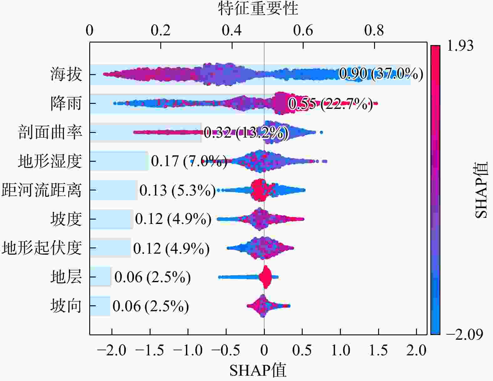
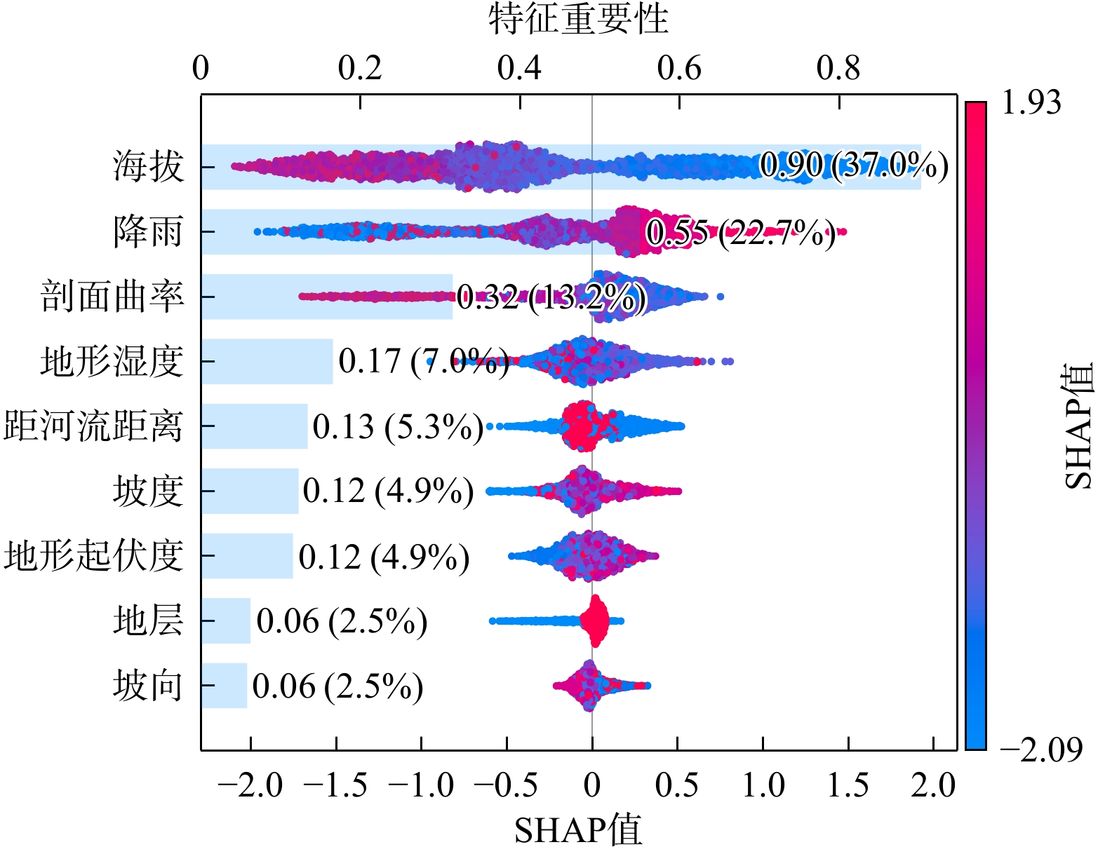
图 16 SHAP可视化蜂巢和特征贡献图
Figure 16. Beeswarm and feature contribution plots via SHAP visualization
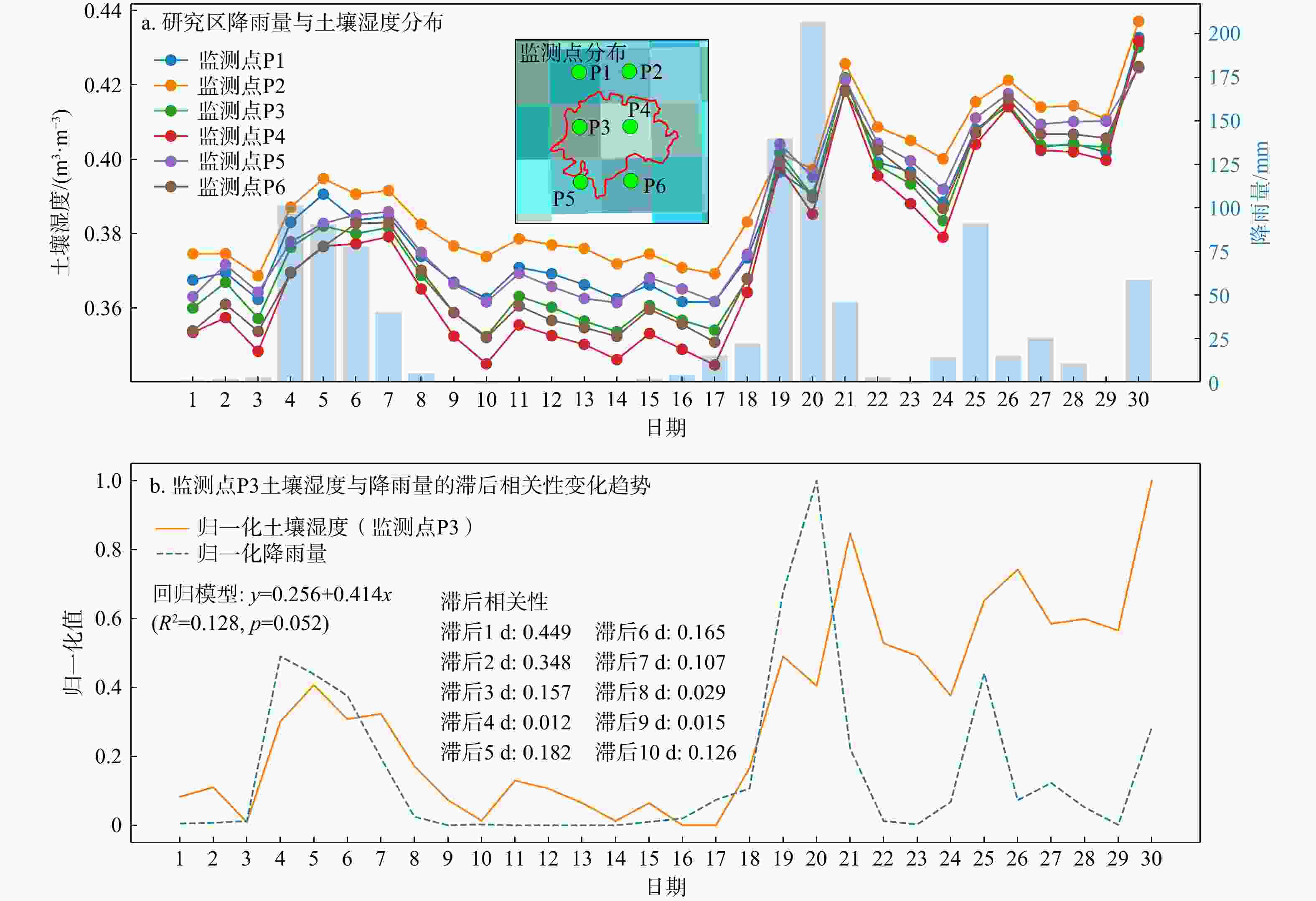
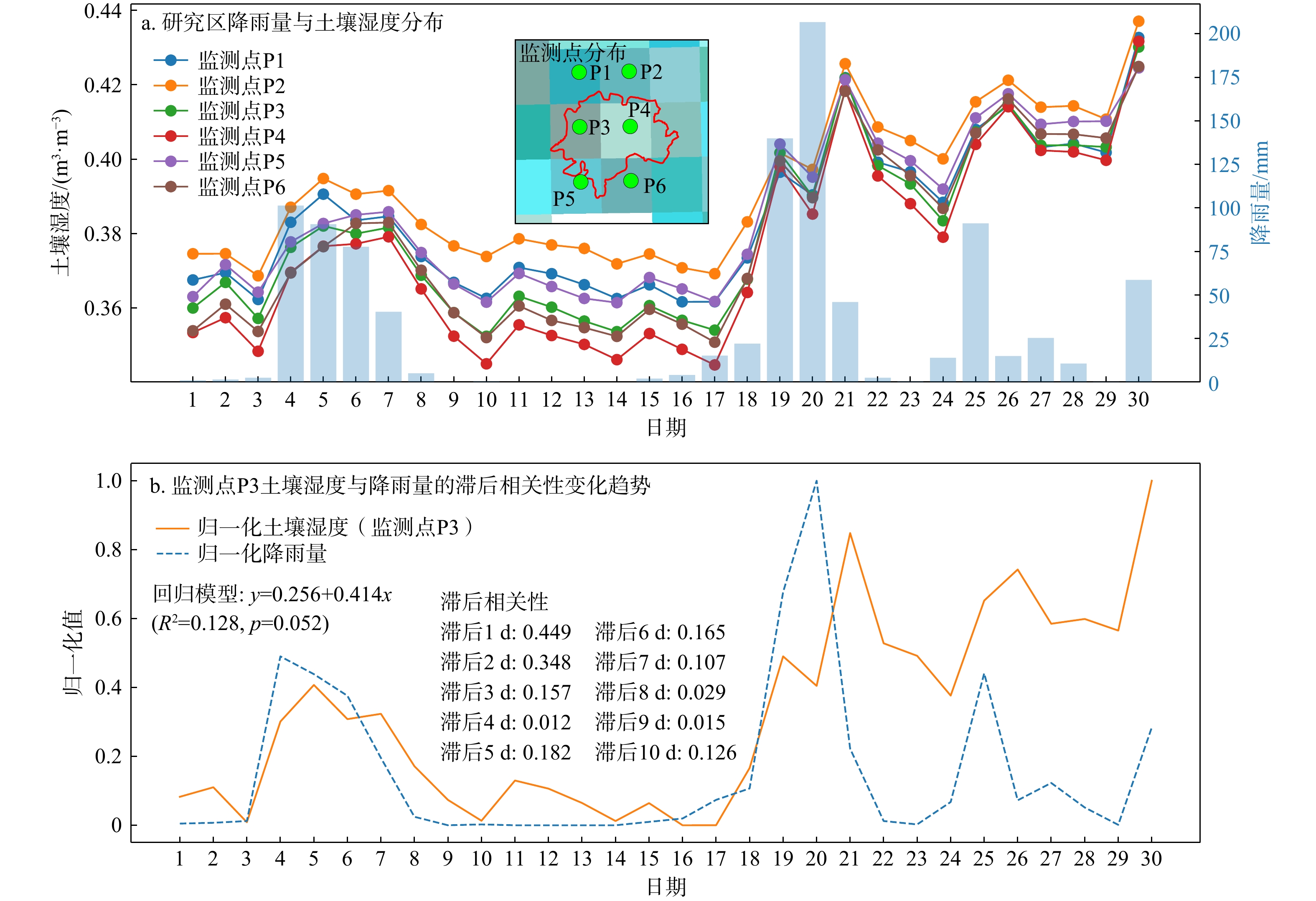
图 17 2024年4月研究区土壤湿度与降雨量的滞后相关性
Figure 17. Lag correlation between soil moisture and rainfall of the study area in April 2024
表 1 研究区不同模型滑坡易发性分区统计
Table 1. Statistics of landslide susceptibility zoning for different models in the study area
模型 易发性
分区斜坡单
元数/个分区面
积/km2面积占
比A/%灾害数
量/个灾害占
比N/%比值
(N/A)LR 极低 994 86.19 38.15 56 3.96 0.10 低 638 48.95 21.66 124 8.77 0.40 中 535 43.29 19.16 340 24.05 1.26 高 420 31.89 14.11 510 36.07 2.56 极高 239 15.63 6.92 384 27.16 3.93 SVM 极低 1219 96.88 42.88 71 5.02 0.12 低 560 45.79 20.26 139 9.83 0.49 中 408 34.66 15.34 271 19.17 1.25 高 312 23.99 10.62 320 22.63 2.13 极高 327 24.63 10.90 613 43.35 3.98 RF 极低 1336 108.94 48.21 72 5.09 0.11 低 603 45.58 20.17 186 13.15 0.65 中 342 27.44 12.14 221 15.63 1.29 高 301 24.89 11.02 404 28.57 2.59 极高 244 19.11 8.46 531 37.55 4.44 XGBoost 极低 1695 130.72 57.85 153 10.82 0.19 低 357 28.53 12.63 189 13.37 1.06 中 212 19.41 8.59 171 12.09 1.41 高 212 18.48 8.18 218 15.42 1.88 极高 350 28.80 12.75 683 48.30 3.79 注:LR. 逻辑回归;SVM. 支持向量机;RF. 随机森林;XGBoost. 极限梯度提升;下同  下载: 导出CSV
表 2 4个模型AUC值统计结果
Table 2. Statistical results of AUC values for four models
模型 AUC值 最小值 最大值 均值 中值 标准差 LR 0.75 0.87 0.81 0.81 0.0434 SVM 0.77 0.89 0.84 0.84 0.0383 RF 0.82 0.90 0.86 0.86 0.0247 XGBoost 0.83 0.89 0.86 0.86 0.0229
下载: 导出CSV
-
[1] 许强, 徐繁树, 蒲川豪, 等. 2024年4月广东韶关江湾镇极端降雨诱发群发性滑坡初步分析[J]. 武汉大学学报(信息科学版), 2024, 49(8): 1264-1274. doi: 10.13203/j.whugis20240202XU Q, XU F S, PU C H, et al. Preliminary analysis of extreme rainfall-induced cluster landslides in Jiangwan Township, Shaoguan, Guangdong, April 2024[J]. Geomatics and Information Science of Wuhan University, 2024, 49(8): 1264-1274. (in Chinese with English abstract doi: 10.13203/j.whugis20240202 [2] 文海家, 宋宸昊, 向学坤, 等. 强降雨诱发滑坡群识别的光学遥感变化检测方法[J]. 测绘科学, 2022, 47(5): 193-202. doi: 10.16251/j.cnki.1009-2307.2022.05.024WEN H J, SONG C H, XIANG X K, et al. Optical remote sensing change detection method for the identification of landslide clusters induced by heavy rainfall[J]. Science of Surveying and Mapping, 2022, 47(5): 193-202. (in Chinese with English abstract doi: 10.16251/j.cnki.1009-2307.2022.05.024 [3] 瞿渝, 王志辉, 于会泳, 等. 基于双时相遥感影像差异信息的深度学习滑坡检测[J]. 航天返回与遥感, 2023, 44(2): 153-162. doi: 10.3969/j.issn.1009-8518.2023.02.016QU Y, WANG Z H, YU H Y, et al. Deep learning landslide extraction based on difference information of dual-phase remote sensing images[J]. Spacecraft Recovery & Remote Sensing, 2023, 44(2): 153-162. (in Chinese with English abstract doi: 10.3969/j.issn.1009-8518.2023.02.016 [4] 王辉, 范硕超, 黄晓胤, 等. 基于光学影像的滑坡实时自动识别技术研究[J]. 航天返回与遥感, 2024, 45(1): 147-160. doi: 10.3969/j.issn.1009-8518.2024.01.013WANG H, FAN S C, HUANG X Y, et al. Research on real-time automatic landslide recognition technology based on optical image[J]. Spacecraft Recovery & Remote Sensing, 2024, 45(1): 147-160. (in Chinese with English abstract doi: 10.3969/j.issn.1009-8518.2024.01.013 [5] 杨明生, 李山山, 冯钟葵. 结合纹理特征分析与比辐射率估计的震后滑坡提取[J]. 遥感学报, 2018, 22(增刊1): 212-223.YANG M S, LI S S, FENG Z K. Post-seismic landslide extraction by combining texture analysis and emissivity estimating[J]. National Remote Sensing Bulletin, 2018, 22(S1): 212-223. (in Chinese with English abstract [6] 孙昆襄, 丁雨淋, 曾浩炜, 等. 基于精细DEM的同震滑坡隐患自动提取方法[J]. 测绘地理信息, 2022, 47(4): 82-86. doi: 10.14188/j.2095-6045.2020018SUN K X, DING Y L, ZENG H W, et al. An automatic extraction method for hidden hazards of co-seismic landslides based on fine DEM[J]. Journal of Geomatics, 2022, 47(4): 82-86. (in Chinese with English abstract doi: 10.14188/j.2095-6045.2020018 [7] 杨文涛, 汪明, 史培军. 利用NDVI时间序列识别汶川地震滑坡的分布[J]. 遥感信息, 2012, 27(6): 45-48. doi: 10.3969/j.issn.1000-3177.2012.06.008YANG W T, WANG M, SHI P J. Identification of landslides in Wenchuan earthquake affected region using NDVI time series[J]. Remote Sensing Information, 2012, 27(6): 45-48. (in Chinese with English abstract doi: 10.3969/j.issn.1000-3177.2012.06.008 [8] BEHLING R, ROESSNER S, KAUFMANN H, et al. Automated spatiotemporal landslide mapping over large areas using RapidEye time series data[J]. Remote Sensing, 2014, 6(9): 8026-8055. doi: 10.3390/rs6098026 [9] SUN D L, XU J H, WEN H J, et al. Assessment of landslide susceptibility mapping based on Bayesian hyperparameter optimization: A comparison between logistic regression and random forest[J]. Engineering Geology, 2021, 281: 105972. doi: 10.1016/j.enggeo.2020.105972 [10] GOYES-PEÑAFIEL P, HERNANDEZ-ROJAS A. Landslide susceptibility index based on the integration of logistic regression and weights of evidence: A case study in Popayan, Colombia[J]. Engineering Geology, 2021, 280: 105958. doi: 10.1016/j.enggeo.2020.105958 [11] SELAMAT S N, MAJID N A, TAHA M R, et al. Landslide susceptibility model using artificial neural network (ANN) approach in Langat River Basin, Selangor, Malaysia[J]. Land, 2022, 11(6): 833. doi: 10.3390/land11060833 [12] HUANG F M, ZHANG J, ZHOU C B, et al. A deep learning algorithm using a fully connected sparse autoencoder neural network for landslide susceptibility prediction[J]. Landslides, 2020, 17(1): 217-229. doi: 10.1007/s10346-019-01274-9 [13] SUN D L, WEN H J, WANG D Z, et al. A random forest model of landslide susceptibility mapping based on hyperparameter optimization using bayes algorithm[J]. Geomorphology, 2020, 362: 107201. doi: 10.1016/j.geomorph.2020.107201 [14] SHAN Y F, XU Z, ZHOU S S, et al. Landslide hazard assessment combined with InSAR deformation: A case study in the Zagunao River Basin, Sichuan Province, southwestern China[J]. Remote Sensing, 2024, 16(1): 99. [15] KAVZOGLU T, TEKE A. Predictive performances of ensemble machine learning algorithms in landslide susceptibility mapping using random forest, extreme gradient boosting (XGBoost) and natural gradient boosting (NGBoost)[J]. Arabian Journal for Science and Engineering, 2022, 47(6): 7367-7385. doi: 10.1007/s13369-022-06560-8 [16] 郑德凤, 潘美伊, 高敏, 等. 集中降雨影响下辽南仙人洞国家级自然保护区滑坡灾害多因子风险评价[J]. 地质科技通报, 2025, 44(2): 48-58. doi: 10.19509/j.cnki.dzkq.tb20240509ZHENG D F, PAN M Y, GAO M, et al. Multi-factor risk assessment of landslide disasters under concentrated rainfall in Xianrendong national nature reserve in southern Liaoning Province[J]. Bulletin of Geological Science and Technology, 2025, 44(2): 48-58. (in Chinese with English abstract doi: 10.19509/j.cnki.dzkq.tb20240509 [17] PHAM B T, NGUYEN-THOI T, QI C C, et al. Coupling RBF neural network with ensemble learning techniques for landslide susceptibility mapping[J]. Catena, 2020, 195: 104805. doi: 10.1016/j.catena.2020.104805 [18] WANG H J, ZHANG L M, LUO H Y, et al. AI-powered landslide susceptibility assessment in Hong Kong[J]. Engineering Geology, 2021, 288: 106103. doi: 10.1016/j.enggeo.2021.106103 [19] HAKIM W L, REZAIE F, NUR A S, et al. Convolutional neural network (CNN) with metaheuristic optimization algorithms for landslide susceptibility mapping in Icheon, South Korea[J]. Journal of Environmental Management, 2022, 305: 114367. doi: 10.1016/j.jenvman.2021.114367 [20] 李光明, 杨玉飞, 唐亚明, 等. 数据驱动模型评价滑坡易发性的对比研究: 以黄河中游流域为例[J]. 西北地质, 2025, 58(2): 51-65.LI G M, YANG Y F, TANG Y M, et al. Comparison study in landslide susceptibility assessment by using data-driven models: A case study from the middle stream of the Yellow River[J]. Northwestern Geology, 2025, 58(2): 51-65. (in Chinese with English abstract [21] 袁旭山, 刘京会, 黄龙生, 等. 基于机器学习模型的新源县滑坡易发性评估[J]. 科学技术与工程, 2025, 25(5): 1815-1826.YUAN X S, LIU J H, HUANG L S, et al. Assessment of landslide susceptibility in Xinyuan County based on machine learning models[J]. Science Technology and Engineering, 2025, 25(5): 1815-1826. (in Chinese with English abstract [22] SHANG H, SU L X, LIU Y, et al. Assessment of the effects of characterization methods selection on the landslide susceptibility: A comparison between logistic regression (LR), naive Bayes (NB) and radial basis function network (RBF Network)[J]. Bulletin of Engineering Geology and the Environment, 2025, 84(3): 134. [23] ZHOU C, YIN K L, CAO Y, et al. Landslide susceptibility modeling applying machine learning methods: A case study from Longju in the Three Gorges Reservoir area, China[J]. Computers & Geosciences, 2018, 112: 23-37. doi: 10.1016/j.cageo.2017.11.019 [24] 刘伟旭, 吴亮. 武江区滑坡和崩塌地质灾害形成条件浅析[J]. 冶金与材料, 2022, 14(1): 135-136. doi: 10.3969/j.issn.1674-5183.2022.01.066LIU W X, WU L. An analysis of the formation conditions of landslides and avalanches geological hazards in Wujiang District[J]. Metallurgy and Materials, 2022, 14(1): 135-136. (in Chinese with English abstract doi: 10.3969/j.issn.1674-5183.2022.01.066 [25] 李晨阳, 王新春, 何春珍, 等. 全国1∶ 200000 数字地质图(公开版)空间数据库[J]. 中国地质, 2019, 46(增刊1): 1-10.LI C Y, WANG X C, HE C Z, et al. National 1∶200000 digital geological map (public version) spatial database[J]. Geology in China, 2019, 46(S1): 1-10. (in Chinese)[26] 吴洁玲, 查轩, 陈世发, 等. 1951—2018年韶关不同量级降雨侵蚀力变化[J]. 水土保持学报, 2021, 35(4): 21-26. doi: 10.13870/j.cnki.stbcxb.2021.04.004WU J L, ZHA X, CHEN S F, et al. Variations of rainfall erosivity of different magnitudes in Shaoguan from 1951 to 2018[J]. Journal of Soil and Water Conservation, 2021, 35(4): 21-26. (in Chinese with English abstract doi: 10.13870/j.cnki.stbcxb.2021.04.004 [27] SHAO X Y, MA S Y, XU C, et al. Insight into the characteristics and triggers of loess landslides during the 2013 heavy rainfall event in the Tianshui area, China[J]. Remote Sensing, 2023, 15(17): 4304. doi: 10.3390/rs15174304 [28] SHAN Y F, DAI X A, LI W L, et al. Detecting spatial-temporal changes of urban environment quality by remote sensing-based ecological indices: A case study in Panzhihua City, Sichuan Province, China[J]. Remote Sensing, 2022, 14(17): 4137. doi: 10.3390/rs14174137 [29] 杨锟, 叶永, 谢旋. 基于离散元模型的聚合型滑坡碎屑流聚合角度影响研究[J]. 地质科技通报, 2025, 44(2): 116-129. doi: 10.19509/j.cnki.dzkq.2021.0087YANG K, YE Y, XIE X. Influence of aggregation angle of aggregated landslide debris flows based on discrete element model[J]. Bulletin of Geological Science and Technology, 2025, 44(2): 116-129. (in Chinese with English abstract doi: 10.19509/j.cnki.dzkq.2021.0087 [30] 储栋, 管小彬, 沈焕锋. 考虑全时间序列信息的NDVI变分重建方法[J]. 地理与地理信息科学, 2023, 39(3): 31-39. doi: 10.3969/j.issn.1672-0504.2023.03.005CHU D, GUAN X B, SHEN H F. A variational method for reconstructing NDVI time series considering full time information[J]. Geography and Geo-Information Science, 2023, 39(3): 31-39. (in Chinese with English abstract doi: 10.3969/j.issn.1672-0504.2023.03.005 [31] QIU H J, SU L L, TANG B Z, et al. The effect of location and geometric properties of landslides caused by rainstorms and earthquakes[J]. Earth Surface Processes and Landforms, 2024, 49(7): 2067-2079. doi: 10.1002/esp.5816 [32] MA H, WANG F W, FU Z J, et al. Characterizing the clustered landslides triggered by extreme rainfall during the 2024 typhoon Gaemi in Zixing City, Hunan Province, China[J]. Landslides, 2025, 22(7): 2311-2329. doi: 10.1007/s10346-025-02510-1 [33] LI C Q, ZHANG J, GAO L C, et al. Spatial Clustering and distribution characteristics of large landslides in the Yalong River Basin, China[J]. Geomorphology, 2025, 475: 109667. doi: 10.1016/j.geomorph.2025.109667 [34] LEE S, RYU J H, KIM I S. Landslide susceptibility analysis and its verification using likelihood ratio, logistic regression, and artificial neural network models: Case study of Youngin, Korea[J]. Landslides, 2007, 4(4): 327-338. [35] SUN D L, GU Q Y, WEN H J, et al. Assessment of landslide susceptibility along mountain highways based on different machine learning algorithms and mapping units by hybrid factors screening and sample optimization[J]. Gondwana Research, 2023, 123: 89-106. doi: 10.1016/j.gr.2022.07.013 [36] ALVIOLI M, GUZZETTI F, MARCHESINI I. Parameter-free delineation of slope units and terrain subdivision of Italy[J]. Geomorphology, 2020, 358: 107124. doi: 10.1016/j.geomorph.2020.107124 [37] ZHANG W G, GU X, TANG L B, et al. Application of machine learning, deep learning and optimization algorithms in geoengineering and geoscience: Comprehensive review and future challenge[J]. Gondwana Research, 2022, 109: 1-17. [38] 文刚, 高孟平, 高振宇, 等. 多因子协同作用下的云南省山火风险评估[J]. 广东电力, 2022, 35(4): 96-102. doi: 10.3969/j.issn.1007-290X.2022.004.012WEN G, GAO M P, GAO Z Y, et al. Risk assessment of wildfires in Yunnan Province under the synergy of multi-factor[J]. Guangdong Electric Power, 2022, 35(4): 96-102. (in Chinese with English abstract doi: 10.3969/j.issn.1007-290X.2022.004.012 [39] 陈晓华, 王志平, 吴杰康, 等. 基于VMD和IAO-SVM的电压暂降源识别方法[J]. 广东电力, 2023, 36(1): 59-67. doi: 10.3969/j.issn.1007-290X.2023.01.007CHEN X H, WANG Z P, WU J K, et al. Voltage sag source identification method based on VMD and IAO-SVM[J]. Guangdong Electric Power, 2023, 36(1): 59-67. (in Chinese with English abstract doi: 10.3969/j.issn.1007-290X.2023.01.007 [40] 姚海成, 李豹, 黄兆棽. 基于随机森林算法的电力系统小干扰稳定评估校正[J]. 广东电力, 2023, 36(7): 60-69. doi: 10.3969/j.issn.1007-290X.2023.07.007YAO H C, LI B, HUANG Z C. Small signal stability assessment and correction control of power system based on random forest algorithm[J]. Guangdong Electric Power, 2023, 36(7): 60-69. (in Chinese with English abstract doi: 10.3969/j.issn.1007-290X.2023.07.007 [41] CHEN T Q, GUESTRIN C. XGBoost: A scalable tree boosting system[C]//Proceedings of the 22nd ACM SIGKDD International Conference on Knowledge Discovery and Data Mining. San Francisco California USA: ACM, 2016: 785-794. [42] 单云锋, 李为乐, 周胜森, 等. 长江上游区域滑坡灾害生态风险评估[J]. 生态学报, 2024, 44(24): 11437-11449. doi: 10.20103/j.stxb.202405131077SHAN Y F, LI W L, ZHOU S S, et al. Ecological risk assessment of landslide hazards in the upper reaches of the Yangtze River region[J]. Acta Ecologica Sinica, 2024, 44(24): 11437-11449. (in Chinese with English abstract doi: 10.20103/j.stxb.202405131077 [43] ZHANG J Y, MA X L, ZHANG J L, et al. Insights into geospatial heterogeneity of landslide susceptibility based on the SHAP-XGBoost model[J]. Journal of Environmental Management, 2023, 332: 117357. doi: 10.1016/j.jenvman.2023.117357 [44] 黎子豪, 蒋恕. 基于机器学习和SHAP算法的声波测井曲线重构及可解释性分析[J]. 地质科技通报, 2025, 44(1): 321-331. doi: 10.19509/j.cnki.dzkq.tb20230504LI Z H, JIANG S. Reconstructing and interpreting analysis of sonic logging curves based on machine learning and SHAP algorithm[J]. Bulletin of Geological Science and Technology, 2025, 44(1): 321-331. (in Chinese with English abstract doi: 10.19509/j.cnki.dzkq.tb20230504 [45] YANG G, ZHAO L, QIN Y, et al. Clustered landslides induced by rainfall in Jiangwan Town, Shaoguan City, Guangdong Province, China[J]. Landslides., 2025, 22(4): 1325-133. -

 下载:
下载:


 点击查看大图
计量
- 文章访问数: 501
- PDF下载量: 132
- 被引次数: 0

