
 投审稿入口
投审稿入口

Risk assessment of Rangduchang North landslide in Wanzhou District, Three Gorges Reservoir area
-
摘要:
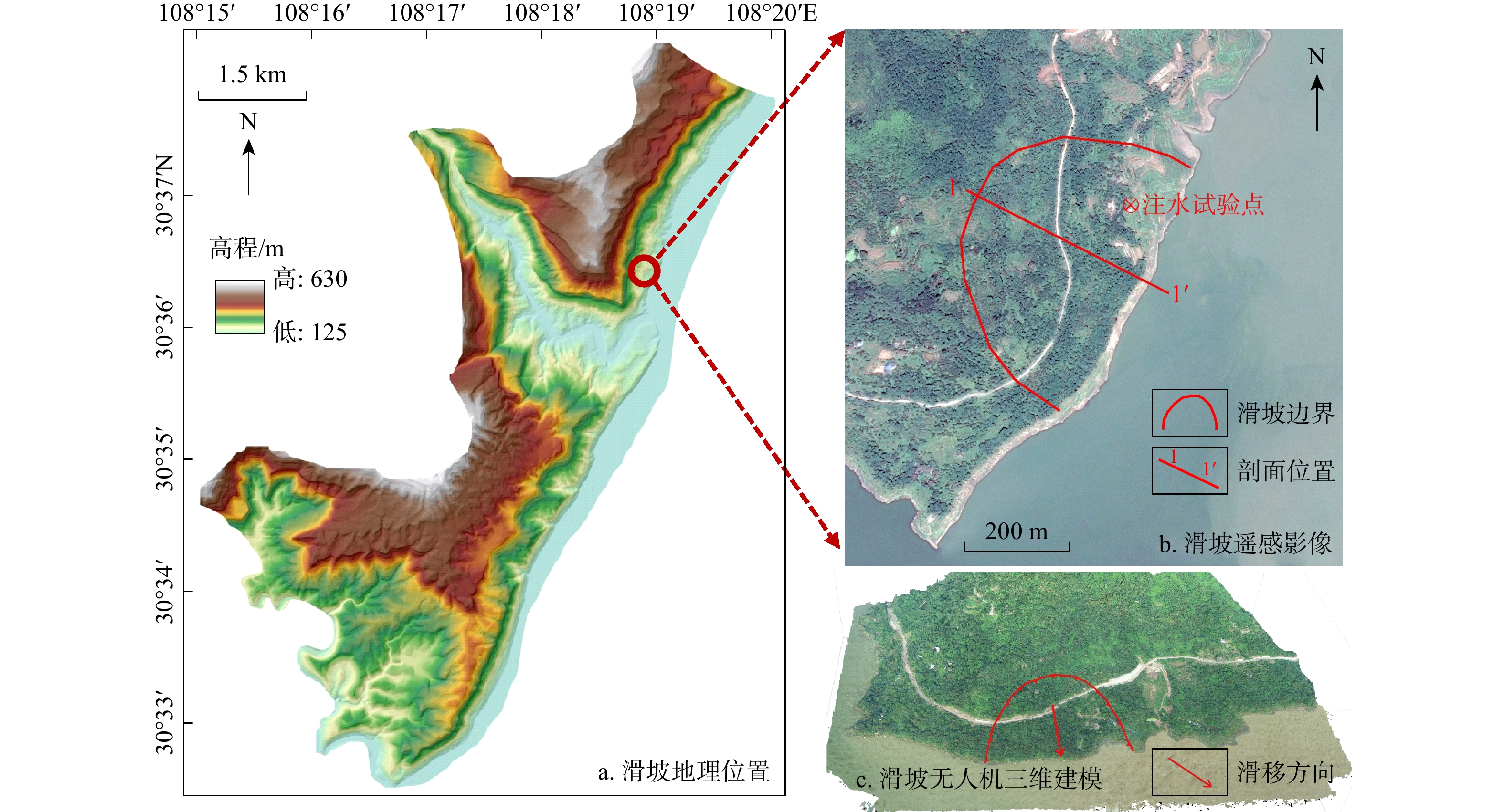
重庆市万州区地处我国三峡库区核心地带,区域内地质灾害广泛发育,对城镇发展产生了较大影响,开展单体滑坡风险研究具有重要的意义。以万州区瀼渡场北滑坡为研究对象,开展了单体滑坡灾害风险评价研究。基于野外实地调查,通过 GEO-Studio和DAN3D分别开展滑坡失稳概率分析及运动过程分析,得到滑坡危险性评价结果;结合承灾体抗灾能力分析,开展易损性定量评价;叠加滑坡灾害危险性、承灾体易损性及承灾体价值开展了瀼渡场北滑坡风险评价。结果显示:在天然自重及荷载情况下,瀼渡场北滑坡为稳定状态,在降雨工况下稳定状态均为欠稳定,在100 a一遇10 d降雨条件下稳定性为1.011,破坏概率为23.53%。瀼渡场北滑坡百年一遇的降雨强度下失稳破坏造成的总人口伤亡风险为2人,总经济损失风险为114.1万元。研究成果精准量化了极端降雨条件下瀼渡场北滑坡的失稳概率、承灾体易损性及综合风险值,明确了滑坡失稳后的人口伤亡与经济损失分布特征,不仅为瀼渡镇地质灾害防灾减灾管理提供了具体的数据基础和技术指导,也为三峡库区同类单体滑坡的风险评价工作提供了参考范式,对库区滑坡灾害防灾减灾工作具有重要的实践意义。
Abstract:ObjectiveWanzhou district of Chongqing, as the core area of China's Three Gorges Reservoir area, is characterized by complex geological structure and frequent landslide disasters due to the combined effects of periodic fluctuation of reservoir water level and heavy rainfall. In this area, about 20 new deformed landslides are added annually, which directly threaten the safety of nearly
100000 people and restrict the sustainable urban development of the reservoir area. Therefore, conducting a systematic quantitative risk assessment of individual landslides is of great practical significance for the prevention and mitigation of geological disasters in the Three Gorges Reservoir area.MethodsIn this study, the Rangduchang North landslide in Wanzhou District was taken as the research object to carry out a comprehensive risk assessment of a single landslide disaster. The research process was carried out in three steps: First, based on the basic data obtained from field investigation, on-site sampling tests and water injection tests, the instability probability analysis of the landslide under different working conditions was carried out by using GEO-Studio, and the motion process simulation of the landslide was completed by using DAN3D, and the comprehensive hazard evaluation results of the Rangduchang North landslide were obtained by integrating the two sets of results, with the working conditions including natural self-weight with surface load conditions and rainfall conditions with different return periods of 20, 50 and 100 years. Second, combined with the analysis of the disaster resistance capacity of disaster-bearing bodies in the landslide affected area, a quantitative vulnerability assessment was carried out from two dimensions of population vulnerability and economic vulnerability, in which the economic vulnerability covered three types of disaster-bearing bodies including residential buildings, transportation roads and land resources, and the specific vulnerability values of various disaster-bearing bodies were determined. Finally, the comprehensive risk assessment of the Rangduchang North Landslide was realized by superposing the three core elements of hazard of landslide disasters, vulnerability and economic value of disaster-bearing bodies, and the population casualty risk and economic loss risk of the landslide under extreme conditions were calculated in detail.
ResultsThe results showed that the Rangduchang North landslide was in a stable state under the natural self-weight and surface load conditions, while all in a slightly unstable state under rainfall conditions with different return periods. Specifically, under the 10-day rainfall condition with a 100-year return period, the landslide had a stability coefficient of 1.011 and a failure probability of 23.53%. Under this extreme rainfall condition, the total population casualty risk caused by the instability and failure of the Rangduchang North landslide was 2 people, including 1 casualty risk for indoor population, 1 for outdoor population, and 0 for floating population on traffic roads in the affected area. The total economic loss risk was 1.141 million yuan, which was composed of three parts:
121000 yuan for residential building damage,1000000 yuan for transportation road damage and15000 yuan for land resource damage.ConclusionThis study has accurately quantified the instability probability, vulnerability of disaster-bearing bodies and comprehensive risk value of the Rangduchang North landslide under extreme rainfall conditions, and clarified the specific distribution characteristics of population casualties and economic losses caused by landslide instability. A systematic quantitative risk assessment framework for a single landslide was constructed by combining multiple numerical simulation software and quantitative vulnerability evaluation models, which not only provides specific data support and technical guidance for the prevention and mitigation of geological disasters in Rangdu Town, but also serves as a reference paradigm for the risk assessment of similar single landslides in the Three Gorges Reservoir area. In general, the research results have important practical significance for the overall geological disaster prevention and mitigation work in the Three Gorges Reservoir area and can provide a useful reference for the geological safety management of reservoir areas with similar geological conditions worldwide.
-
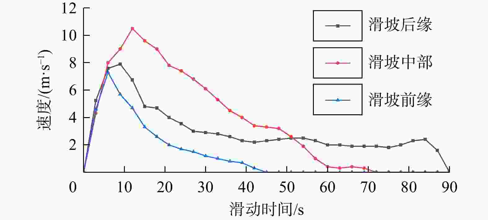
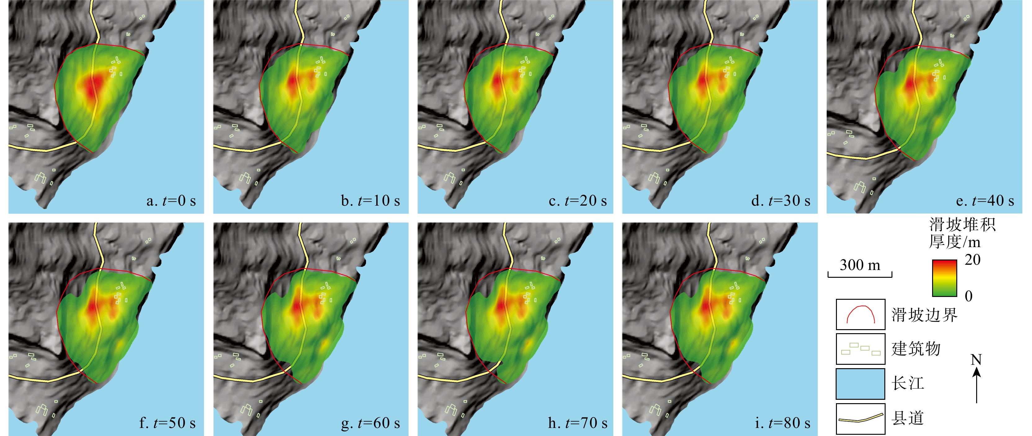
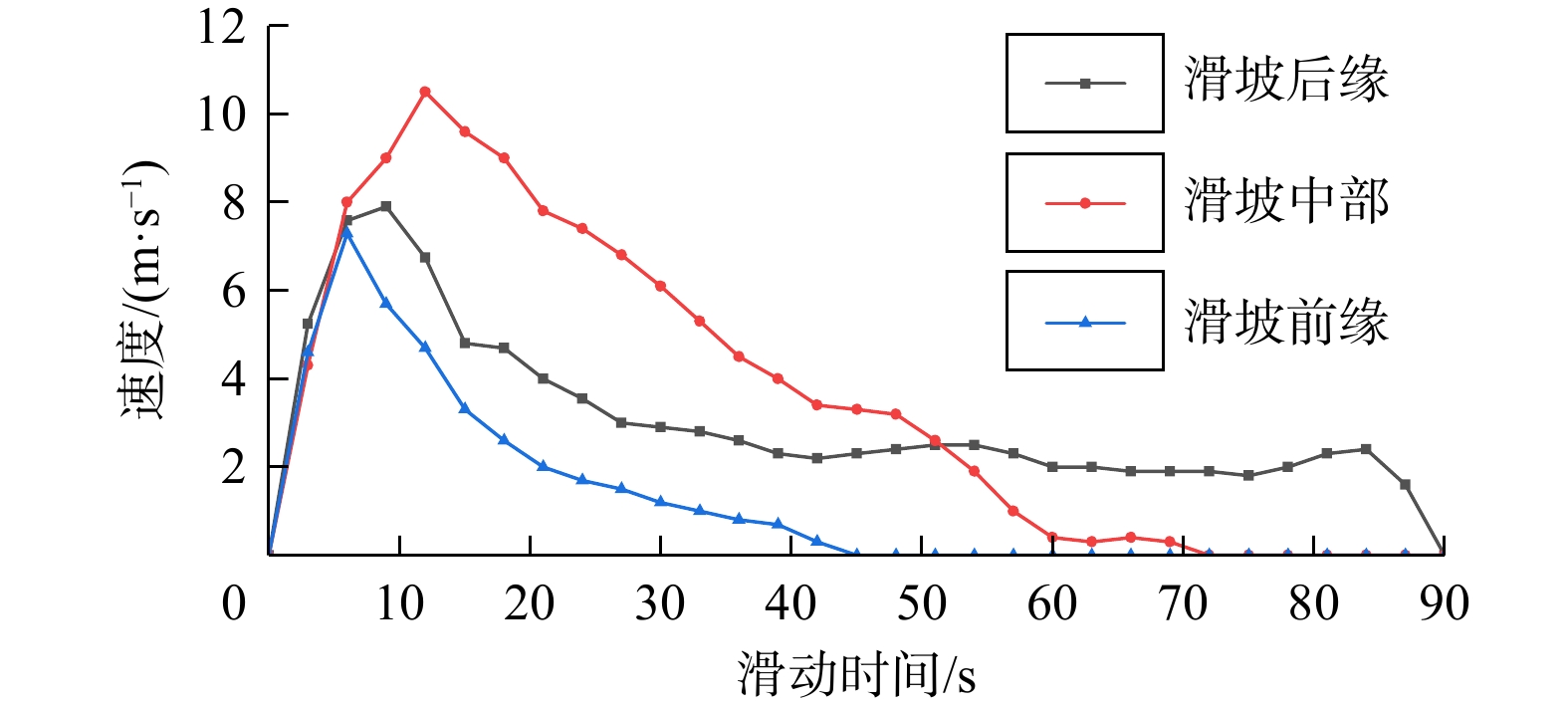
图 4 瀼渡场北滑坡不同位置运动速度
Figure 4. Velocity of movement at different positions of Rangduchang North landslide
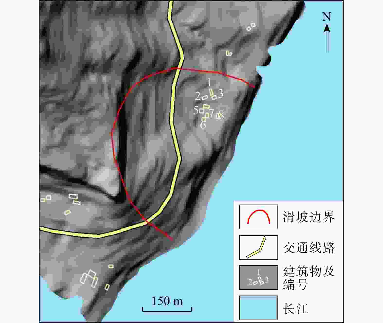
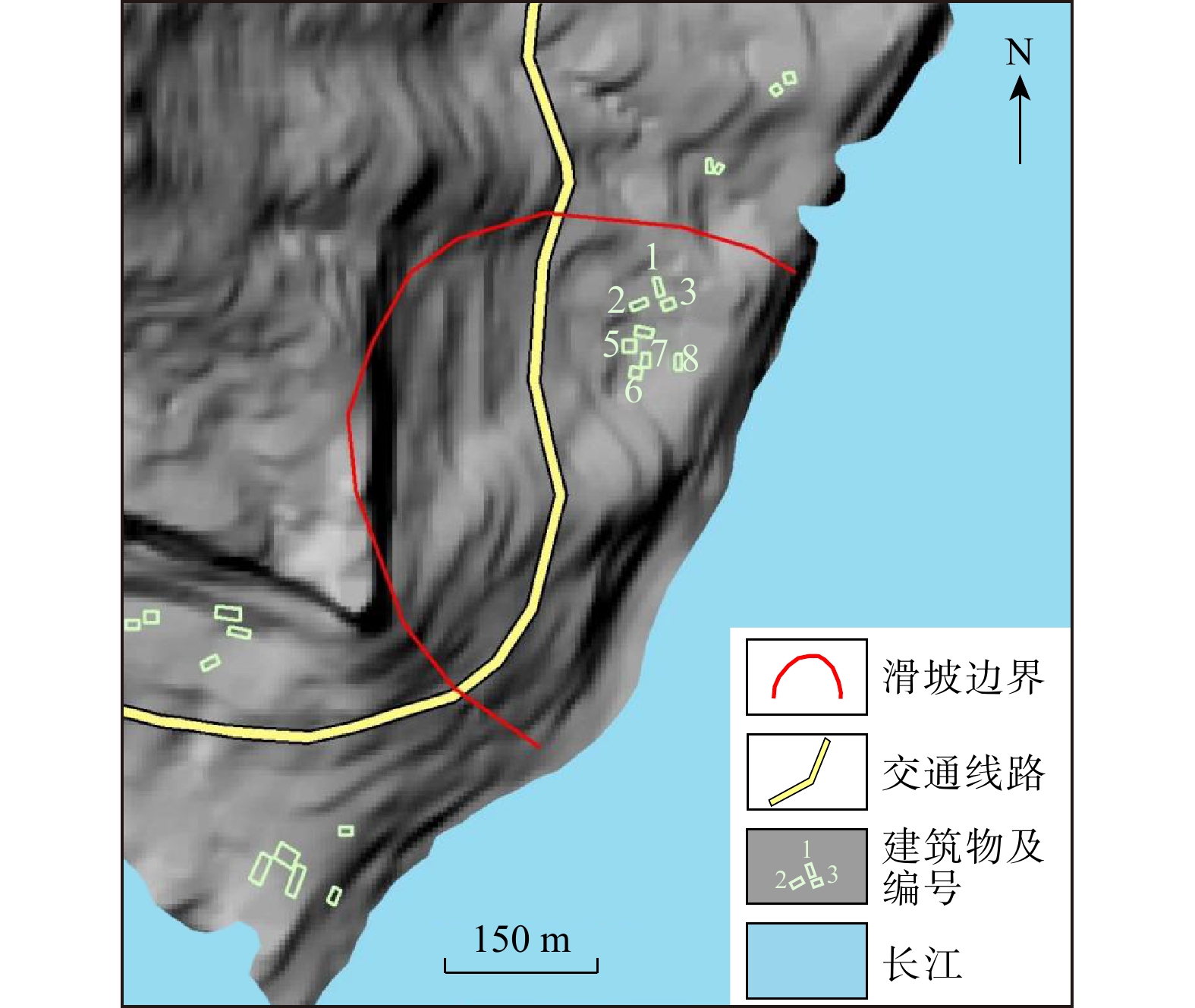
图 5 滑坡影响范围内居民建筑及交通道路分布示意图
Figure 5. Distribution of residential buildings and transportation roads within affected area of landslide
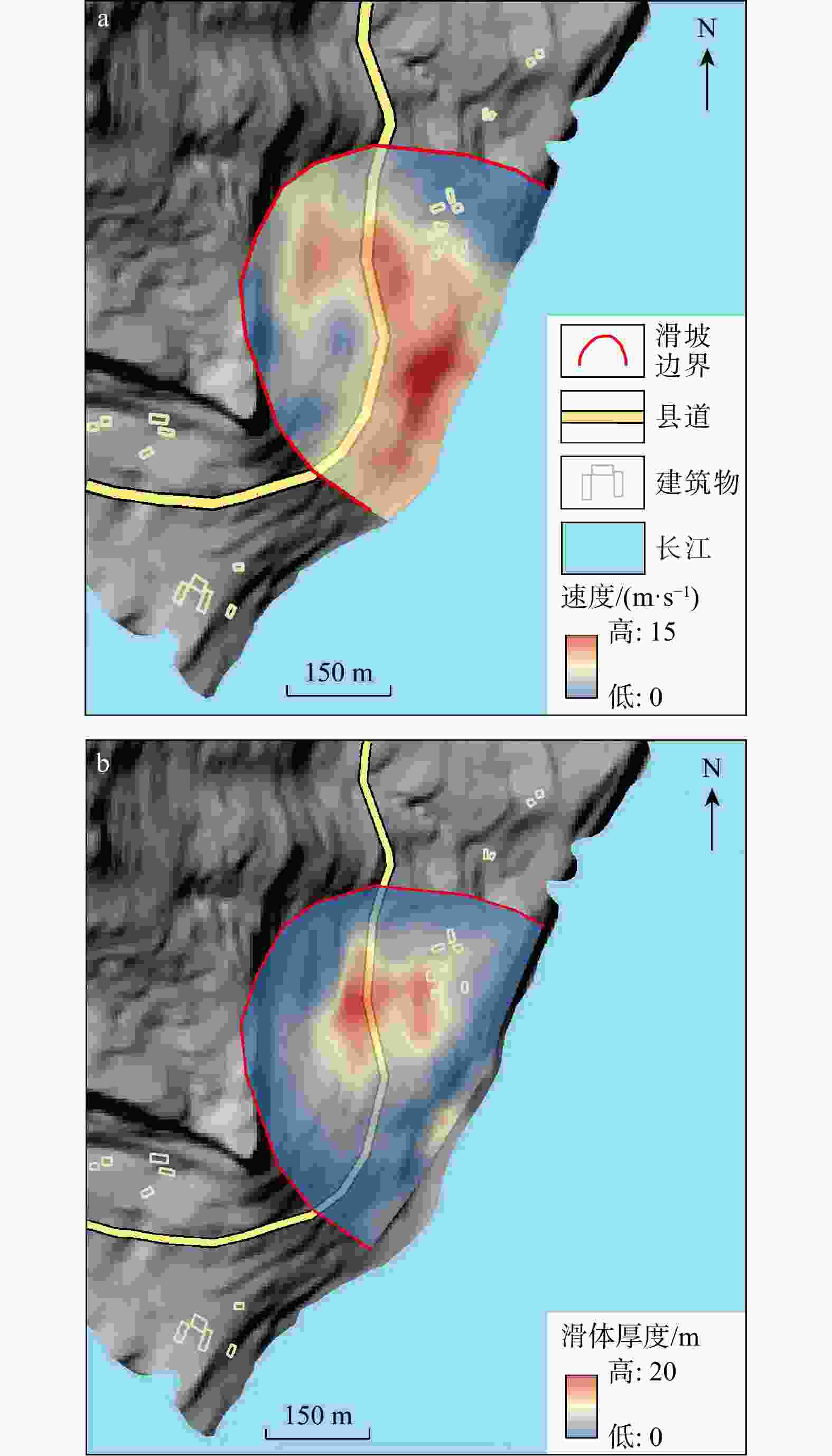
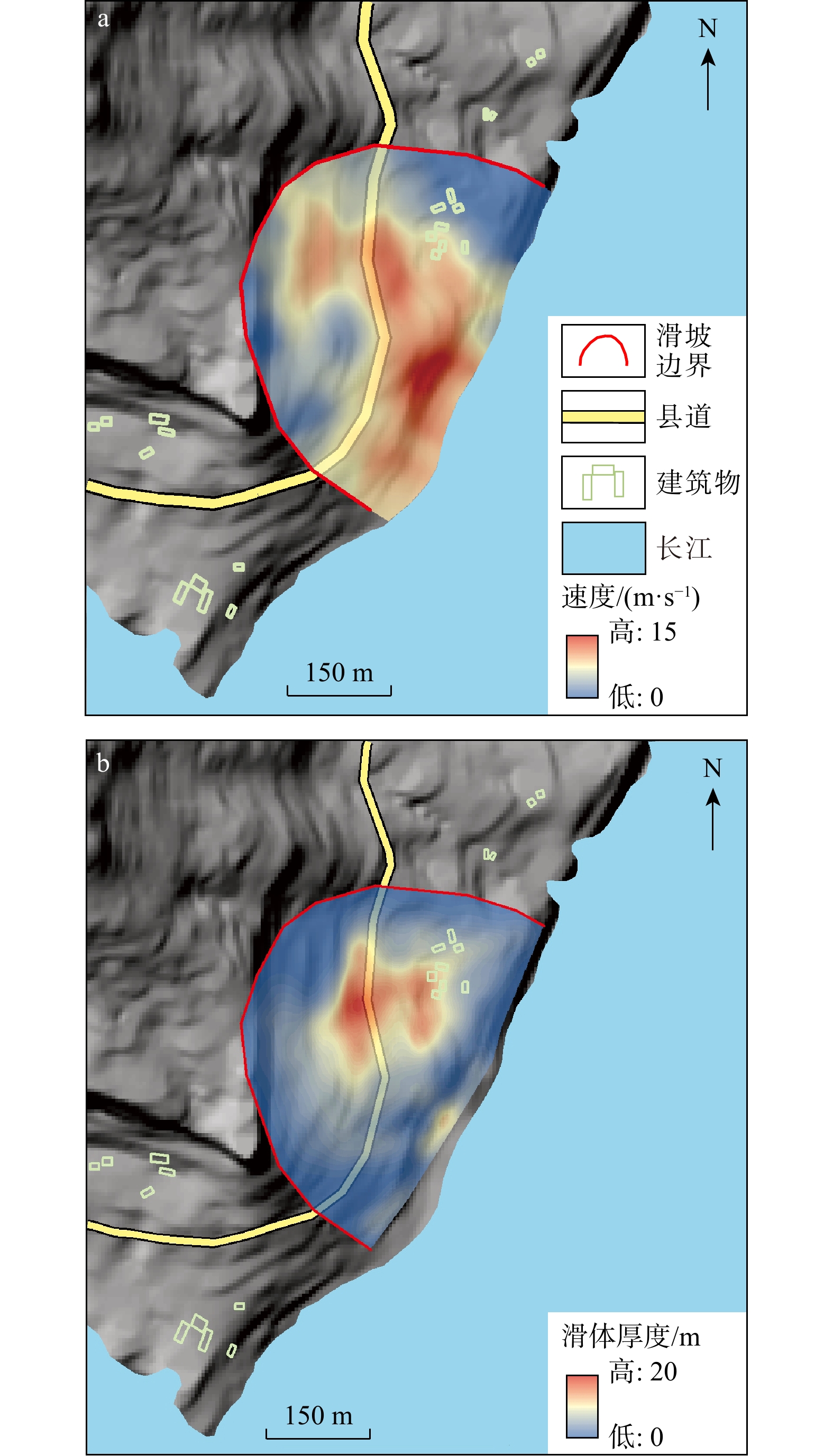
图 6 滑坡滑动过程中最大速度(a)和滑体最大厚度(b)
Figure 6. Maximum velocity (a) and maximum thickness of sliding mass (b) during landslide sliding process
表 1 滑坡力学参数表
Table 1. Landslide mechanical parameters
物质成分 天然重度/
(kN·m−3)饱和重度/
(kN·m−3)天然状态 饱和状态 黏聚力c 内摩擦角φ 黏聚力c 内摩擦角φ 均值/kPa 变异系数 均值/(°) 变异系数 均值/kPa 变异系数 均值/(°) 变异系数 滑体 19.8 21 22.3 0.148 12.4 0.236 18.2 0.152 9.4 0.228 基岩 25.3 25.7 220 — 35.9 — 205 — 35.6 —  下载: 导出CSV
表 2 各工况下滑坡稳定性及破坏概率计算结构
Table 2. Calculation structure of landslide stability and failure probability under various operating conditions
工况 工况描述 稳定性系数Fs 破坏概率$P_{\mathrm{f}} $/% 工况1 自重+地表荷载 1.347 0 工况2 自重+地表荷载+20 a一遇10 d降雨 1.019 19.74 工况3 自重+地表荷载+50 a一遇10 d降雨 1.017 20.29 工况4 自重+地表荷载+100 a一遇10 d降雨 1.016 23.53
下载: 导出CSV
表 3 滑坡影响范围内承灾体类型及价值调查统计
Table 3. Statistical investigation of types and values of disaster-bearing bodies within affected area of landslide
承灾体类型 属性 房屋建筑 编号 1 2 3 4 5 6 7 8 结构 砖混 砖混 砖混 砖混 砖混 砖混 砖混 砖混 楼层 2 2 1 2 1 2 2 2 面积/m2 180 200 90 150 81 170 110 110 室内财产/万元 3 3 2 3 2 3 3 3 造价/万元 1 10 3 1 4 8 7 1 常住
人口/人老人 1 2 1 2 0 1 2 1 小孩 1 1 1 1 2 1 1 1 青年 1 0 0 0 2 1 1 2 交通道路 道路等级 瀼渡镇−甘宁镇县道 影响长度/m 500 宽度/m 10 单价/万元 1 总价/万元 500 车流 流量/(辆·min−1) 0.1 总价/万元 1 人数 1 土地资源 类型 耕地 树木 数量 20亩 1000棵 单价/万元 0.25 0.003 总价/万元 5 3
下载: 导出CSV
表 4 瀼渡场北滑坡居民建筑及室内人口易损性结果
Table 4. Vulnerability results of residential buildings and indoor population in Rangduchang North landslide
房屋
编号滑坡冲击强度(最大值) 建筑物抗
最大冲击力/kPa易损性 滑坡速度/
(m·s−1)滑体
厚度/m滑坡冲击
力/kPa建筑物 室内
人口1 1.5 4.1 2.25 11.5 0.20 0.003 2 2.5 5.5 1.25 11.5 0.54 0.030 3 1.2 1.7 1.44 11.5 0.12 0.002 4 5.0 10.0 25.00 11.5 1.00 0.450 5 1.2 12.0 38.44 11.5 1.00 0.450 6 7.2 11.0 51.84 11.5 1.00 0.450 7 1.1 10.0 43.51 11.5 1.00 0.450 8 3.2 4.4 10.24 11.5 0.90 0.240
下载: 导出CSV
-
[1] LI C D, FU Z Y, WANG Y, et al. Susceptibility of reservoir-induced landslides and strategies for increasing the slope stability in the Three Gorges Reservoir area: Zigui Basin as an example[J]. Engineering Geology, 2019, 261: 105279. doi: 10.1016/j.enggeo.2019.105279 [2] HOU T S, XU G L, ZHANG D Q, et al. Stability analysis of Gongjiacun landslide in the Three Gorges Reservoir area under the action of reservoir water level fluctuation and rainfall[J]. Natural Hazards, 2022, 114(2): 1647-1683. doi: 10.1007/s11069-022-05441-5 [3] 殷跃平. 新三峡库区长期地质安全战略研究[J]. 中国水利, 2024(22): 26-35. doi: 10.3969/j.issn.1000-1123.2024.22.007YIN Y P. Studies on long-term geological safety strategy in the new Three Gorges Reservoir area[J]. China Water Resources, 2024(22): 26-35. (in Chinese with English abstract doi: 10.3969/j.issn.1000-1123.2024.22.007 [4] DOU J, XING K, LU Z W, et al. Comprehensive analysis of July 17, 2024, heavy rainfall-induced landslide at Zigui County in the Three Gorges Reservoir area, China[J]. Landslides, 2025, 22(3): 957-965. doi: 10.1007/s10346-024-02442-2 [5] 黄发明, 殷坤龙, 蒋水华, 等. 基于聚类分析和支持向量机的滑坡易发性评价[J]. 岩石力学与工程学报, 2018, 37(1): 156-167. doi: 10.13722/j.cnki.jrme.2017.0824HUANG F M, YIN K L, JIANG S H, et al. Landslide susceptibility assessment based on clustering analysis and support vector machine[J]. Chinese Journal of Rock Mechanics and Engineering, 2018, 37(1): 156-167. (in Chinese with English abstract doi: 10.13722/j.cnki.jrme.2017.0824 [6] HUANG B L, YIN Y P, TAN J M. Risk assessment for landslide-induced impulse waves in the Three Gorges Reservoir, China[J]. Landslides, 2019, 16(3): 585-596. doi: 10.1007/s10346-018-1115-9 [7] 王林峰, 李林刚, 杨洵. 三峡库区碎石土质岸坡失稳启动机制研究: 以龙江红岩子滑坡为例[J]. 岩土工程学报, 2018, 40(增刊2): 209-214. doi: 10.11779/CJGE2018S2042WANG L F, LI L G, YANG X. Instability initiation mechanism of gravel soil slope in Three Gorges Reservoir: Case study of Hongyanzi landslide in Wushan County[J]. Chinese Journal of Geotechnical Engineering, 2018, 40(S2): 209-214. (in Chinese with English abstract doi: 10.11779/CJGE2018S2042 [8] YAO J M, WANG T, YAO X. Spatial-temporal evolution of landslides spanning the impoundment of Baihetan mega hydropower project revealed by satellite radar interferometry[J]. Remote Sensing of Environment, 2025, 321: 114668. doi: 10.1016/j.rse.2025.114668 [9] VARNES D J. Landslide hazard zonation: A review of principal and practice[M]. Paris: Commission of Landslides of IAEG, 1984. [10] FELL R, COROMINAS J, BONNARD C, et al. Guidelines for landslide susceptibility, hazard and risk zoning for land use planning[J]. Engineering Geology, 2008, 102(3/4): 85-98. [11] 吴益平, 殷坤龙, 姜玮. 浙江省永嘉县滑坡灾害风险预警研究[J]. 自然灾害学报, 2009, 18(2): 124-130. doi: 10.3969/j.issn.1004-4574.2009.02.020WU Y P, YIN K L, JIANG W. Research on landslide disaster risk early warning in Yongjia County, Zhejiang Province[J]. Journal of Natural Disasters, 2009, 18(2): 124-130. (in Chinese with English abstract doi: 10.3969/j.issn.1004-4574.2009.02.020 [12] CHEN P Y, YANG H M, LIU Y, et al. Evaluation of debris flow risk based on independent information data fluctuation weighting method[J]. Rock and Soil Mechanics, 2013, 34(2): 449-454. [13] PAN W W, JIAN L R, LIU T. Grey system theory trends from 1991 to 2018: A bibliometric analysis and visualization[J]. Scientometrics, 2019, 121(3): 1407-1434. doi: 10.1007/s11192-019-03256-z [14] VASU N N, LEE S R, LEE D H, et al. A method to develop the input parameter database for site-specific debris flow hazard prediction under extreme rainfall[J]. Landslides, 2018, 15(8): 1523-1539. doi: 10.1007/s10346-018-0971-7 [15] 肖莉丽. 库岸滑坡涌浪数值模拟研究[D]. 武汉: 中国地质大学(武汉), 2015.XIAO L L. Numerical simulation of landslide-induced surge in reservoir bank[D]. Wuhan: China University of Geosciences (Wuhan), 2015. (in Chinese with English abstract [16] HARBITZ C B, GLIMSDAL S, LØVHOLT F, et al. Rockslide tsunamis in complex fjords: From an unstable rock slope at Åkerneset to tsunami risk in western Norway[J]. Coastal Engineering, 2014, 88: 101-122. doi: 10.1016/j.coastaleng.2014.02.003 [17] 郭玲, 薛晔, 孙鹏翔. 基于LA-GraphCAN的甘肃省泥石流易发性评价[J]. 地质科技通报, 2026, 45(1): 212-224. doi: 10.19509/j.cnki.dzkq.tb20230153GUO L, XUE Y, SUN P X. Susceptibility assessment of debris flow in Gansu Province based on LA-GraphCAN[J]. Bulletin of Geological Science and Technology, 2026, 45(1): 212-224. (in Chinese with English abstract doi: 10.19509/j.cnki.dzkq.tb20230153 [18] 赖国泉, 焦海平, 吴红刚, 等. 山区机场高填方滑坡特征、成灾机理、防治及启示: 以攀枝花机场为例[J]. 地质科技通报, 2026, 45(1): 135-146.LAI G Q, JIAO H P, WU H G, et al. Characteristics, disaster mechanism, prevention and treatment and enlightenment of airport high fill landslide in mountainous area: Taking Panzhihua Airport as an example[J]. Bulletin of Geological Science and Technology, 2026, 45(1): 135-146. (in Chinese with English abstract [19] 豆红强, 刘银, 王浩, 等. 基于异质集成机器学习模型的海岸带滑坡灾害易发性评价与区划[J]. 地质科技通报, 2026, 45(2): 1-13.DOU H Q, LIU Y, WANG H, et al. Susceptibility assessment and zoning of coastal landslides based on heterogeneous ensemble machine learning models[J]. Bulletin of Geological Science and Technology, 2026, 45(2): 1-13. (in Chinese with English abstract [20] 亓莉宁, 郭朝旭, 孟华君, 等. 基于机器学习的高植被覆盖区降雨滑坡识别[J]. 地质科技通报, 2026, 45(1): 185-198. doi: 10.19509/j.cnki.dzkq.tb20240168QI L N, GUO C X, MENG H J, et al. Recognition of rainfall-induced landslide in high vegetation coverage area based on machine learning[J]. Bulletin of Geological Science and Technology, 2026, 45(1): 185-198. (in Chinese with English abstract doi: 10.19509/j.cnki.dzkq.tb20240168 [21] UZIELLI M, NADIM F, LACASSE S, et al. A conceptual framework for quantitative estimation of physical vulnerability to landslides[J]. Engineering Geology, 2008, 102(3/4): 251-256. doi: 10.1016/j.enggeo.2008.03.011 [22] 殷坤龙, 陈丽霞, 张桂荣. 区域滑坡灾害预测预警与风险评价[J]. 地学前缘, 2007, 14(6): 85-97. doi: 10.3321/j.issn:1005-2321.2007.06.011YIN K L, CHEN L X, ZHANG G R. Regional landslide prediction, early warning and risk assessment[J]. Earth Science Frontiers, 2007, 14(6): 85-97. (in Chinese with English abstract doi: 10.3321/j.issn:1005-2321.2007.06.011 [23] 于翠芳, 李永峰. 资产评估[M]. 江苏 徐州: 中国矿业大学出版社, 2006.YU C F, LI Y F. Asset evaluation[M]. Xuzhou Jiangsu: China University of Mining and Technology Press, 2006. (in Chinese) [24] 王佳佳. 三峡库区万州区滑坡灾害风险评估研究[D]. 武汉: 中国地质大学(武汉), 2015.WANG J J. Landslide risk assessment in Wanzhou District of Three Gorges Reservoir area[D]. Wuhan: China University of Geosciences (Wuhan), 2015. (in Chinese with English abstract [25] LI Z H, NADIM F, HUANG H W, et al. Quantitative vulnerability estimation for scenario-based landslide hazards[J]. Landslides, 2010, 7(2): 125-134. doi: 10.1007/s10346-009-0190-3 [26] 杜娟. 单体滑坡灾害风险评价研究[D]. 武汉: 中国地质大学(武汉), 2012.DU J. Single landslide disaster risk assessment[D]. Wuhan: China University of Geosciences (Wuhan), 2012. (in Chinese with English abstract [27] VALENTINE G A. Damage to structures by pyroclastic flows and surges, inferred from nuclear weapons effects[J]. Journal of Volcanology and Geothermal Research, 1998, 87(1/2/3/4): 117-140. doi: 10.1016/s0377-0273(98)00094-8 [28] 孔嘉旭, 庄建琦, 彭建兵, 等. 基于信息量和卷积神经网络的黄土高原滑坡易发性评价[J]. 地球科学, 2023, 48(5): 1711-1729.KONG J X, ZHUANG J Q, PENG J B, et al. Evaluation of landslide susceptibility in Chinese loess plateau based on IV-RF and IV-CNN coupling models[J]. Earth Science, 2023, 48(5): 1711-1729. (in Chinese with English abstract [29] MIAO F S, ZHAO F C, WU Y P, et al. Landslide susceptibility mapping in Three Gorges Reservoir area based on GIS and boosting decision tree model[J]. Stochastic Environmental Research and Risk Assessment, 2023, 37(6): 2283-2303. doi: 10.1007/s00477-023-02394-4 [30] 郭飞, 赖鹏, 黄发明, 等. 基于知识图谱的滑坡易发性评价文献综述及研究进展[J]. 地球科学, 2024, 49(5): 1584-1606. doi: 10.3799/dqkx.2023.058GUO F, LAI P, HUANG F M, et al. Literature review and research progress of landslide susceptibility mapping based on knowledge graph[J]. Earth Science, 2024, 49(5): 1584-1606. (in Chinese with English abstract doi: 10.3799/dqkx.2023.058 [31] WANG J J, LI X, ZHANG H. Deep learning-based 3D geological modeling for landslide risk assessment[J]. Engineering Geology, 2023, 324: 107245. [32] YIN K L, CHEN L X, ZHANG G R. Regional landslide prediction, early warning and risk assessment[J]. Earth Science Frontiers, 2021, 28(5): 1-15. [33] MIAO F S, WU Y P, TÖRÖK Á, et al. Centrifugal model test on a riverine landslide in the Three Gorges Reservoir induced by rainfall and water level fluctuation[J]. Geoscience Frontiers, 2022, 13(3): 101378. doi: 10.1016/j.gsf.2022.101378 [34] 殷坤龙. 滑坡灾害风险分析[M]. 北京: 科学出版社, 2010.YIN K L. Risk analysis of landslide disaster[M]. Beijing: Science Press, 2010. (in Chinese) -

 下载:
下载:

 点击查看大图
计量
- 文章访问数: 374
- PDF下载量: 103
- 被引次数: 0

