
 投审稿入口
投审稿入口

Two-dimensional SNMR imaging based on HED integration under undulating terrain conditions
-
摘要:
传统的地面核磁共振(SNMR)方法在正演计算时往往不考虑地形条件,这会影响二维成像的精确性。基于谐变电偶极子(HED)积分方法对地形起伏情况下的SNMR响应信号特征进行分析,发现地形是影响反演结果的关键因素。通过数值模拟建立单斜模型、堤坝模型2类地质模型,对2类地形条件下的SNMR二维信号特征及反演结果进行对比分析。结果表明,考虑地形起伏的SNMR二维反演结果,在含水体位置、形态和含水量方面与预设模型一致性更好,利用HED积分方法能够克服地形因素影响,有效提升地形起伏条件下含水体边界的识别能力和含水层整体的连续性。结合高密度电阻率法(ERT)在贵阳红枫湖进行场地验证,发现考虑地形起伏的HED积分SNMR二维反演可直观表征地下含水分布,并准确划定含水层位置和形态,更能反映含水层横向分布复杂性,提高了反演的精确性。试验结果验证了基于HED积分的方法能够更好地适应复杂的地形环境,为高精度地下水探测提供一定的技术支撑与方法参考。
-
关键词:
- 地面核磁共振(SNMR) /
- 谐变电偶极子(HED) /
- 地形起伏 /
- 地下水 /
- 信号特征
Abstract:ObjectiveTraditional surface nuclear magnetic resonance (SNMR) methods often neglect terrain conditions during forward modeling, which affects the accuracy of two-dimensional imaging. If the excitation electromagnetic field is still calculated using traditional SNMR methods under such conditions, the accuracy of two-dimensional imaging will be compromised. This study analyzes the characteristics of SNMR response signals under undulating terrain based on the harmonic electric dipole (HED) integral method, revealing that terrain is a key factor affecting inversion results.
MethodsNumerical simulations were conducted to establish two geological models: Monoclinal and embankment models. And a comparative analysis was performed on SNMR two-dimensional signal characteristics and inversion results under different terrain conditions.
ResultsThe results showed that SNMR two-dimensional inversion incorporating undulating terrain achieved better agreement with preset models in terms of water-bearing body location, geometry, and water content. The HED integral method could overcome the influence of terrain factors, effectively enhancing the identification capability of water-bearing body boundaries and the overall continuity of aquifers under undulating terrain conditions. Field validation at Hongfeng Lake in Guiyang, combined with electrical resistivity tomography (ERT), showed that the HED-based SNMR two-dimensional inversion under undulating terrain clearly visualized subsurface water distribution, accurately delineated aquifer locations and geometries, and better reflected the complexity of aquifer lateral distribution, thereby enhancing inversion accuracy.
ConclusionThe experimental results verify that the HED integral method better adapts to complex terrain conditions and provides technical support as well as methodological reference for high-precision groundwater detection.
-
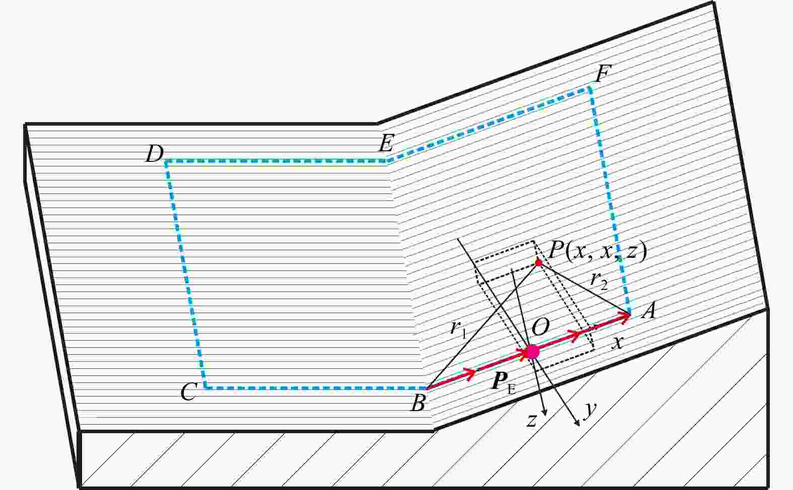
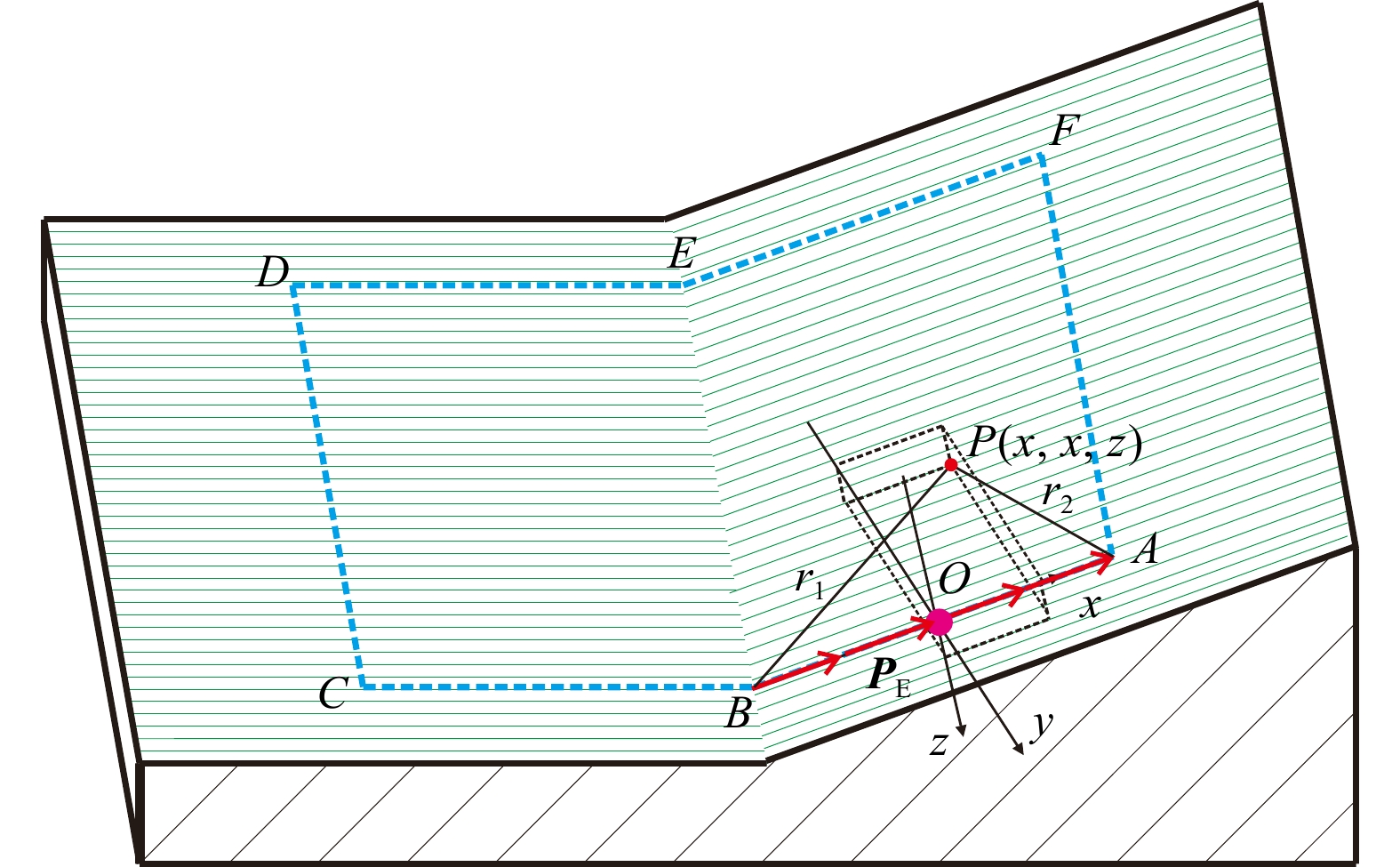
图 1 基于HED积分计算电磁场示意图
A~F. 矩形线圈端点;P. 地下任意点;O. 原点;xyz. 空间坐标系;r1, r2. B点和A点到P点的距离;PE. 电偶极子微元
Figure 1. Schematic diagram of electromagnetic field calculation based on HED integration

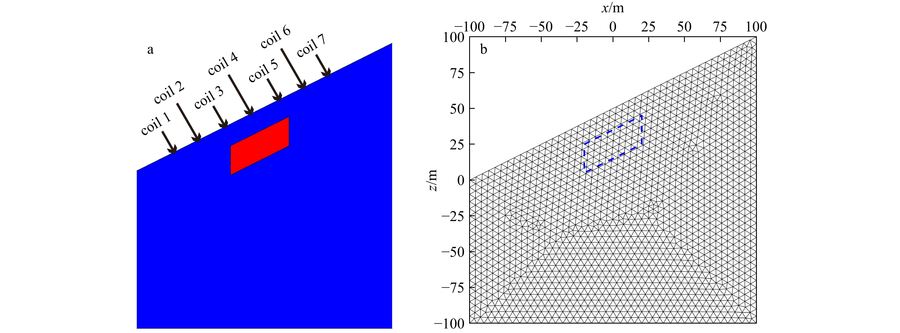
图 2 单斜地形下含水体模型及网格剖分图
a. 单斜地形模型;b. 非结构化三角网格剖分。coil 1~coil 7. 线圈编号;x. 水平距离;z. 深度;红色区域表示预设的块状含水体模型;蓝色虚线表示非结构化三角网格剖分的块状含水体模型边界;下同
Figure 2. Water-bearing body model and mesh division diagram under monoclinal terrain
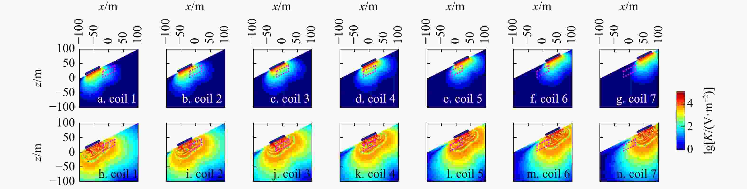
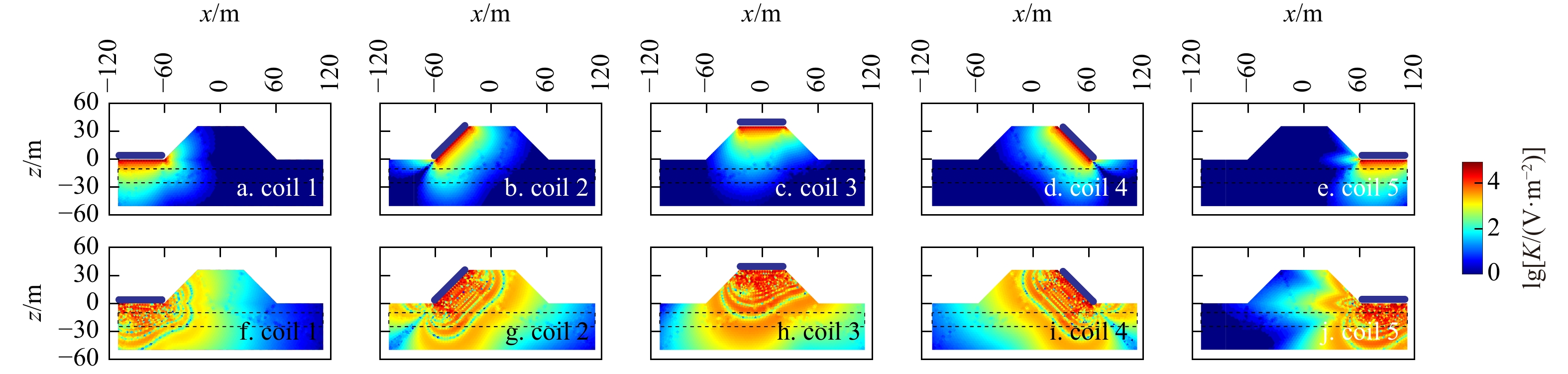
图 3 单斜地形下7组线圈采集的灵敏度核函数示意图
a~g. q=60 A·ms;h~n. q=
15000 A·ms。q. 激发脉冲矩;K. 灵敏度核函数;红色虚线表示预设含水体模型边界;下同Figure 3. Schematic diagram of sensitivity kernel functions of seven coil sets under monoclinal terrain
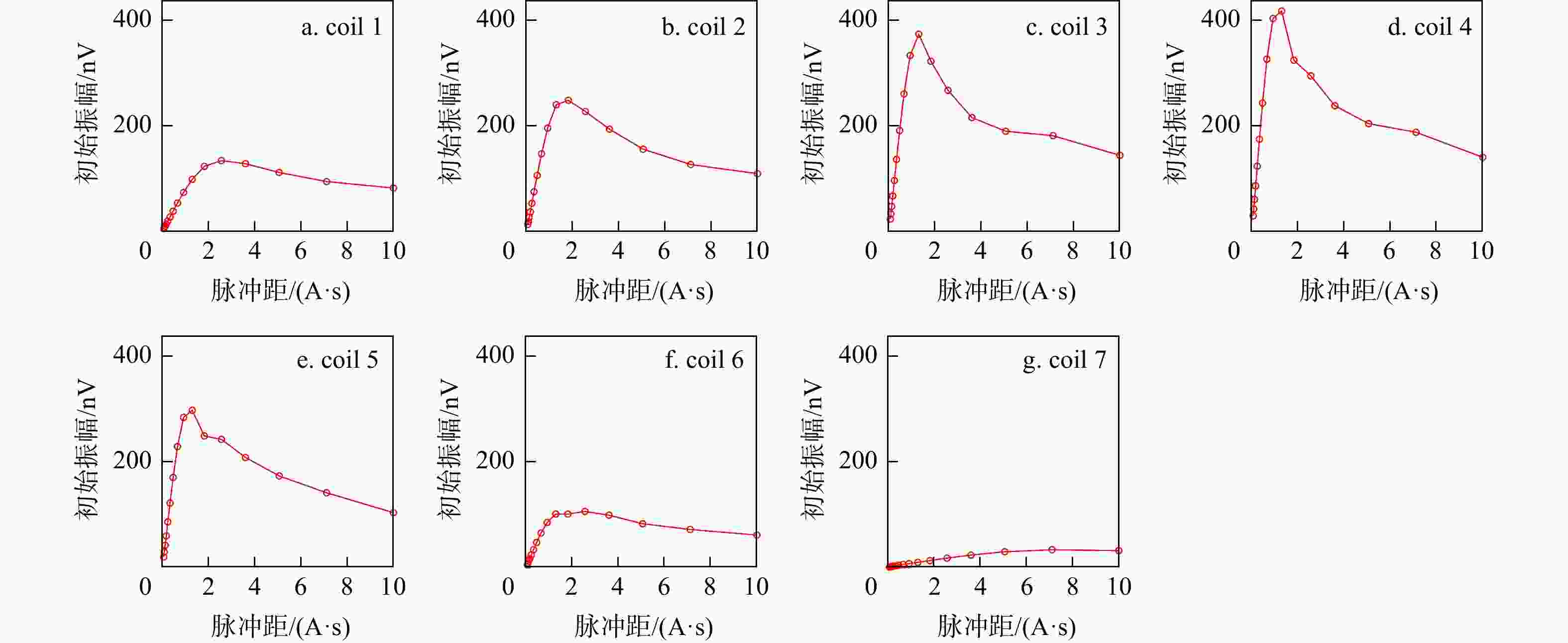
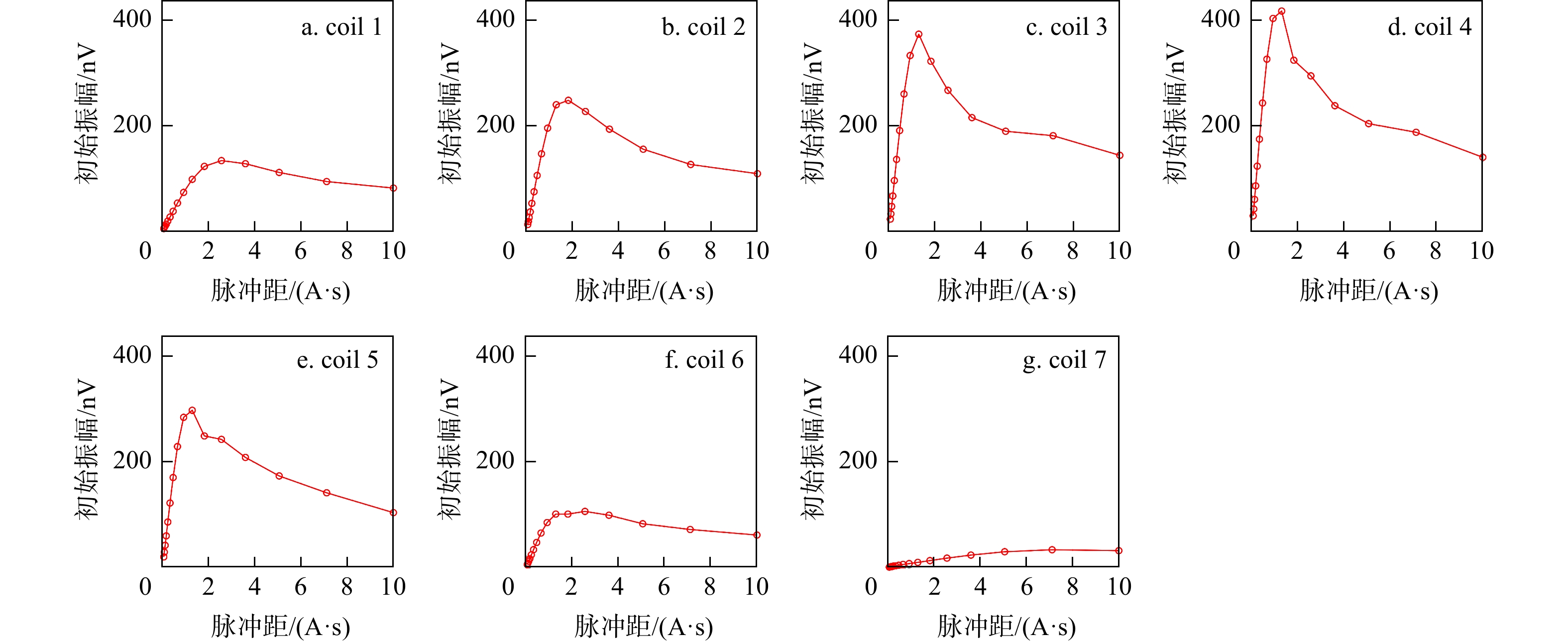
图 4 7次数据采集初始振幅随脉冲矩变化曲线图
Figure 4. Variation curves of initial amplitude with pulse moment from seven data acquisitions
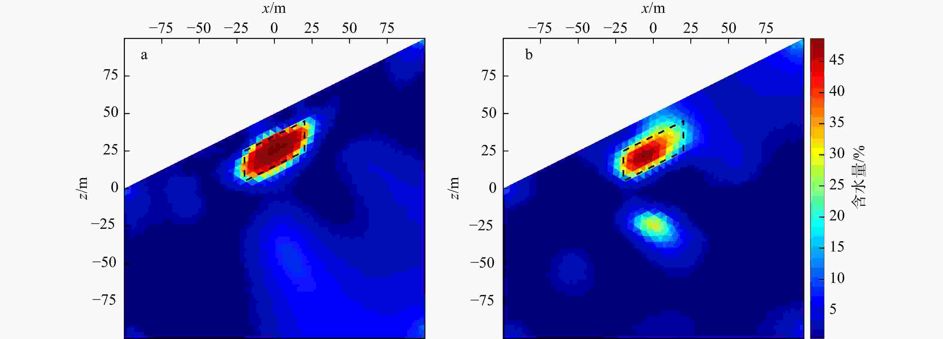
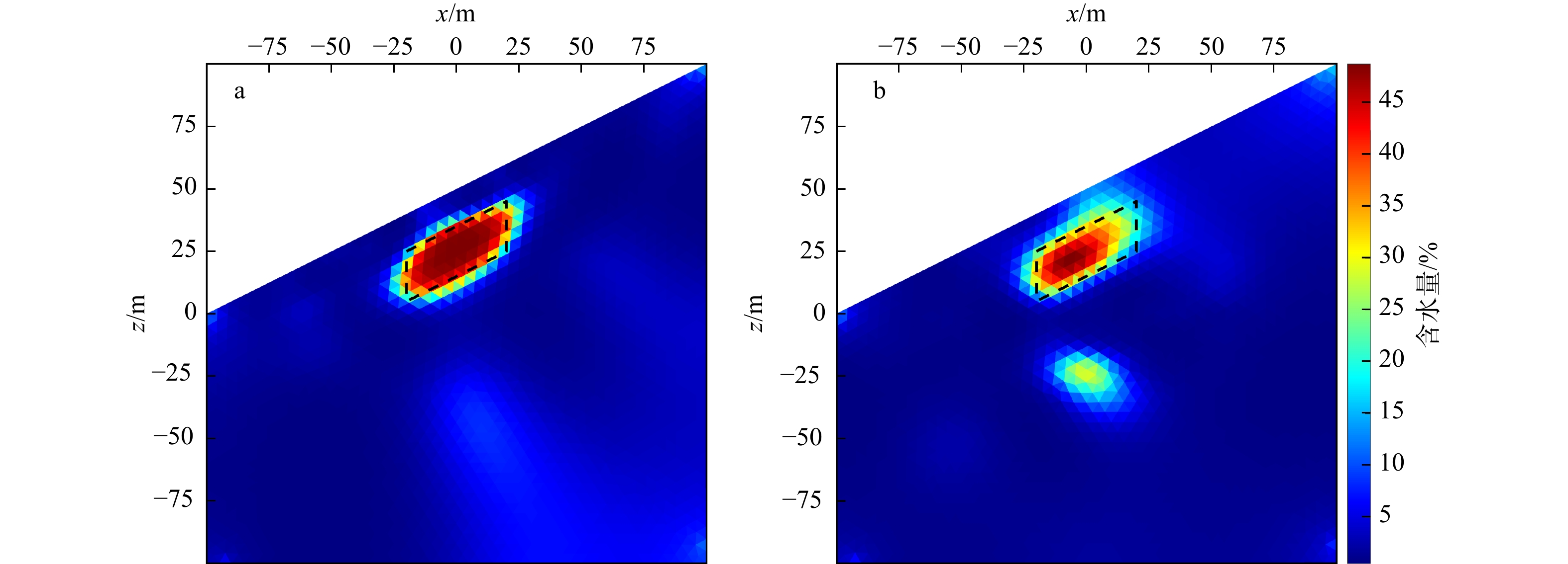
图 5 单斜地形下块状含水体的SNMR二维反演剖面图
a. 考虑地形起伏;b. 忽略地形起伏。黑色虚线表示预设模型的边界
Figure 5. Two-dimensional SNMR inversion profiles of block-shaped water-bearing body under monoclinal terrain
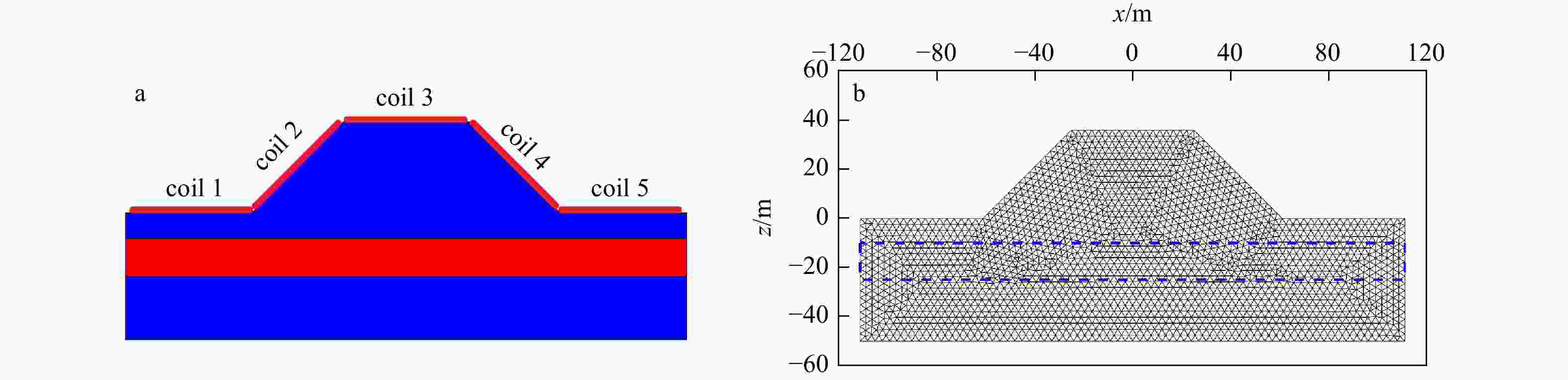
图 6 堤坝地形下含水体模型及网格剖分图
a. 堤坝地形模型;b. 非结构化三角网格剖分。红色区域表示预设的块状含水体模型;蓝色虚线表示非结构化三角网格剖分的块状含水体模型边界
Figure 6. Water-bearing body model and mesh division diagram under embankment terrain
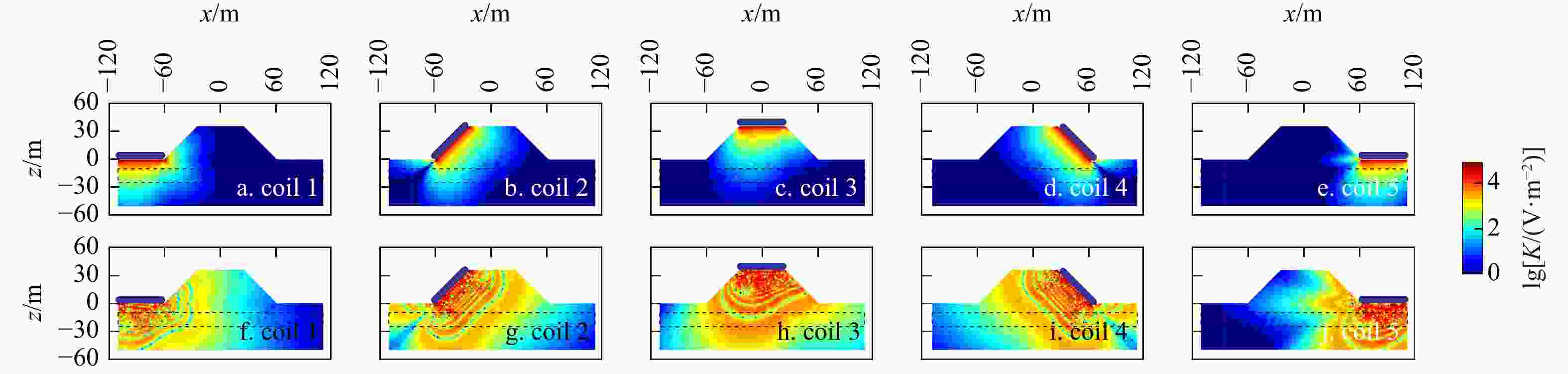
图 7 堤坝地形下5组线圈采集的灵敏度核函数示意图
Figure 7. Schematic diagram of sensitivity kernel functions of five coil sets under embankment terrain
a~e. q=60 A·ms;f~j. q=
15000 A·ms。黑色虚线表示预设含水体模型边界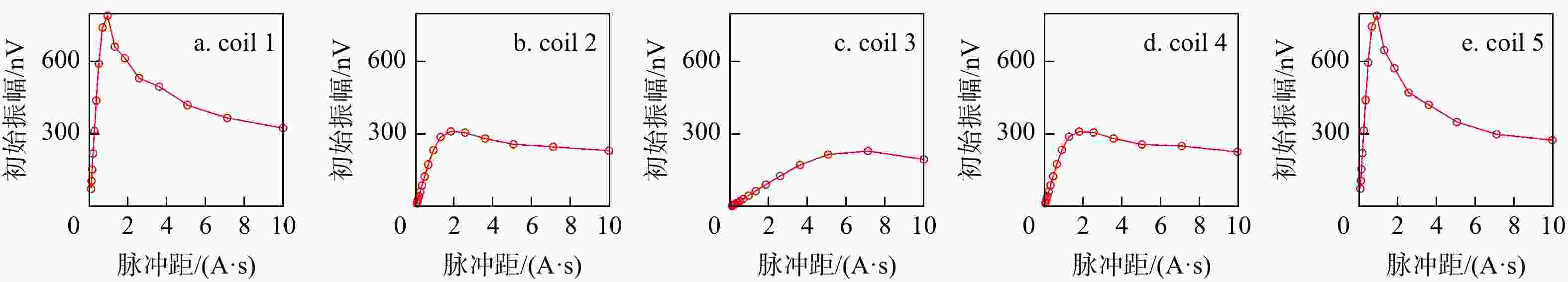
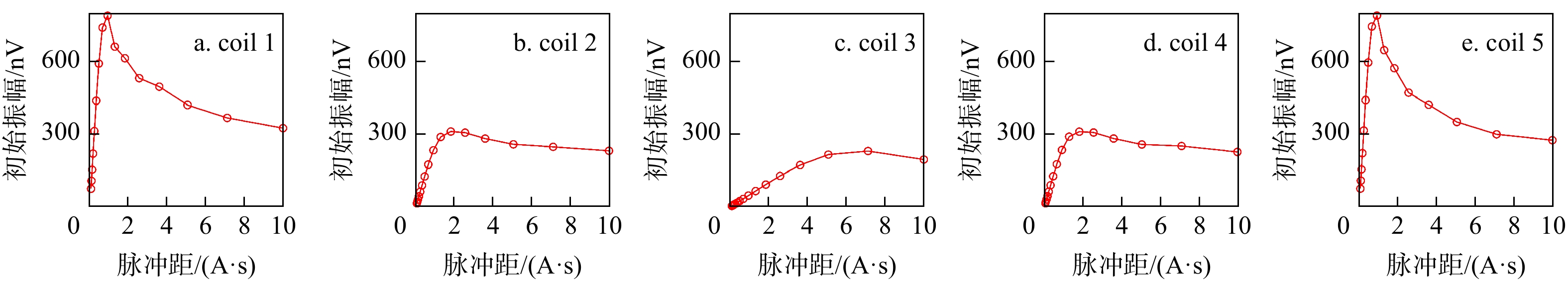
图 8 5次数据采集初始振幅随脉冲矩变化曲线图
Figure 8. Variation curves of initial amplitude with pulse moment from five data acquisitions
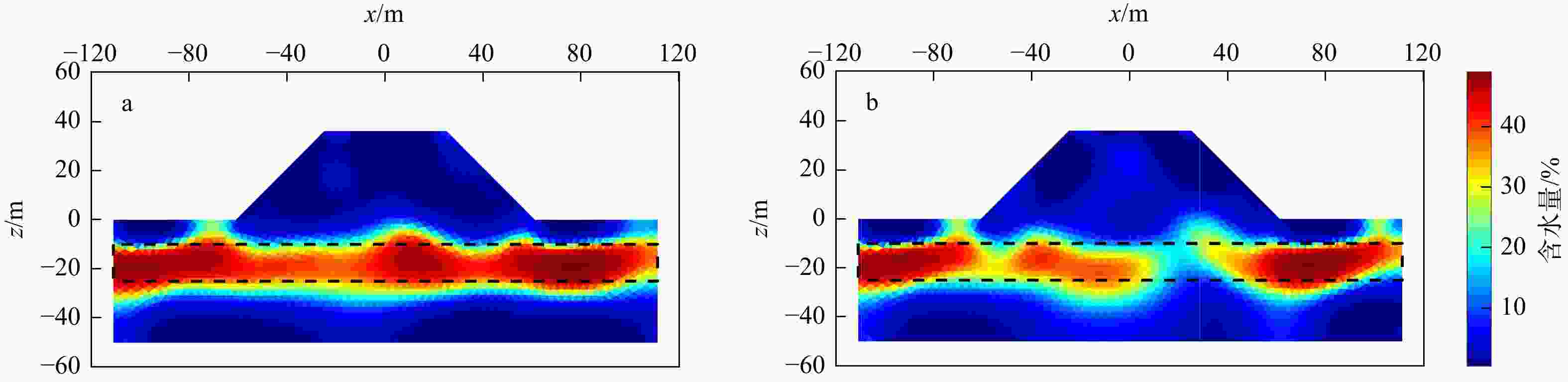
图 9 堤坝地形下块状含水体的SNMR二维反演剖面图
a. 考虑地形起伏;b. 忽略地形起伏。黑色虚线为预设模型边界
Figure 9. Two-dimensional SNMR inversion profiles of block-shaped water-bearing body under embankment terrain
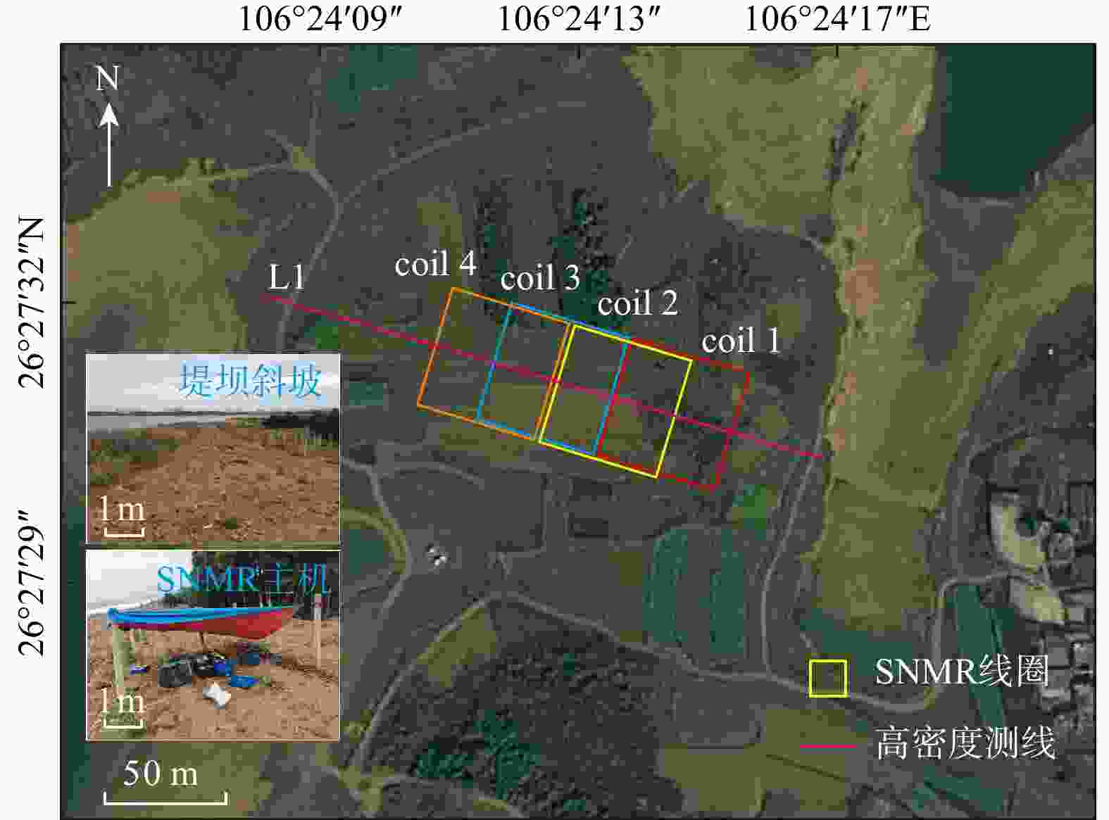
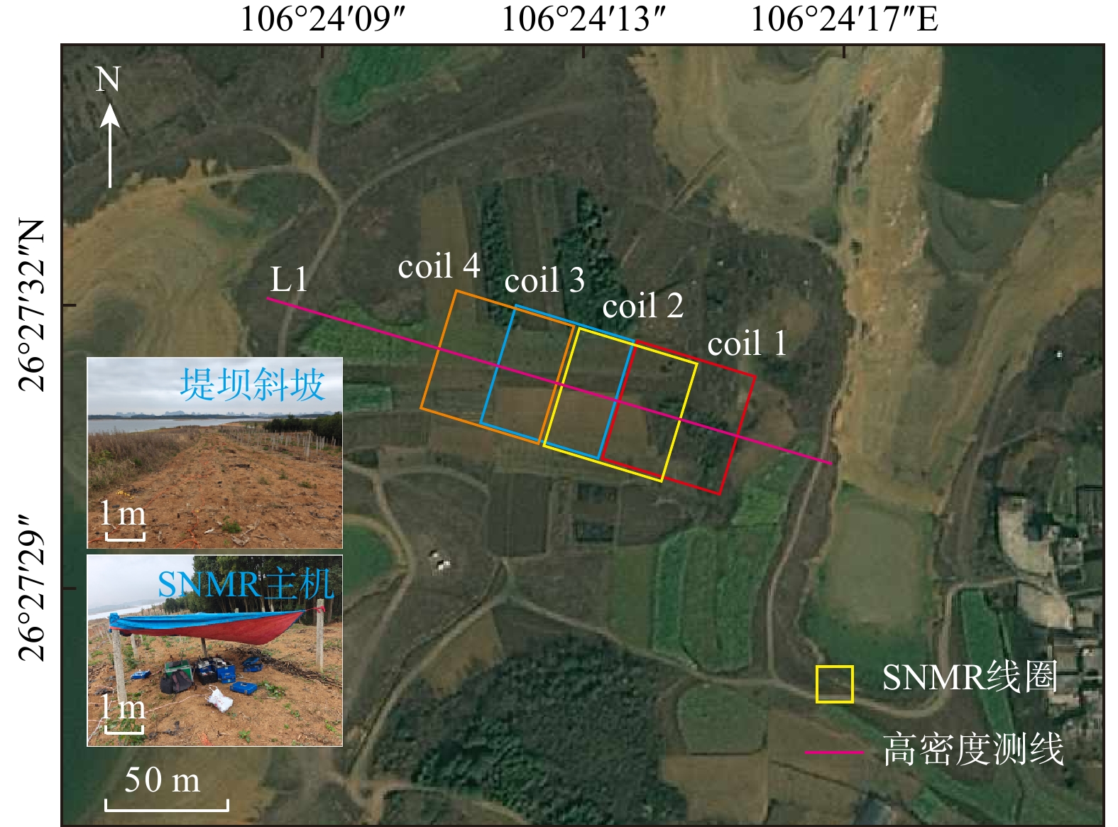
图 10 研究区的地理位置及测线布置图
Figure 10. Geographic location and survey line arrangement of study area

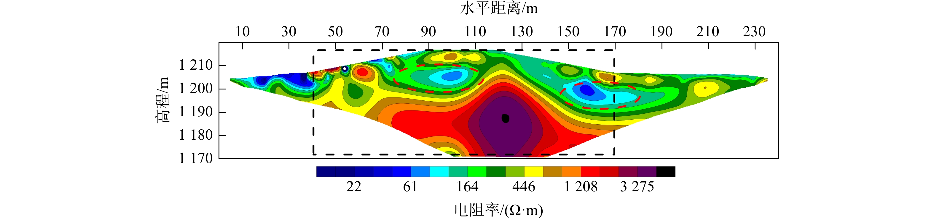
图 11 高密度电阻率法L1测线反演得到的电阻率剖面图
红色椭圆形虚线表示推测修建堤坝回填的松散堆积层边界;黑色矩形虚线表示SNMR线圈的布设范围
Figure 11. Resistivity profile inverted from Line L1 using electrical resistivity tomography
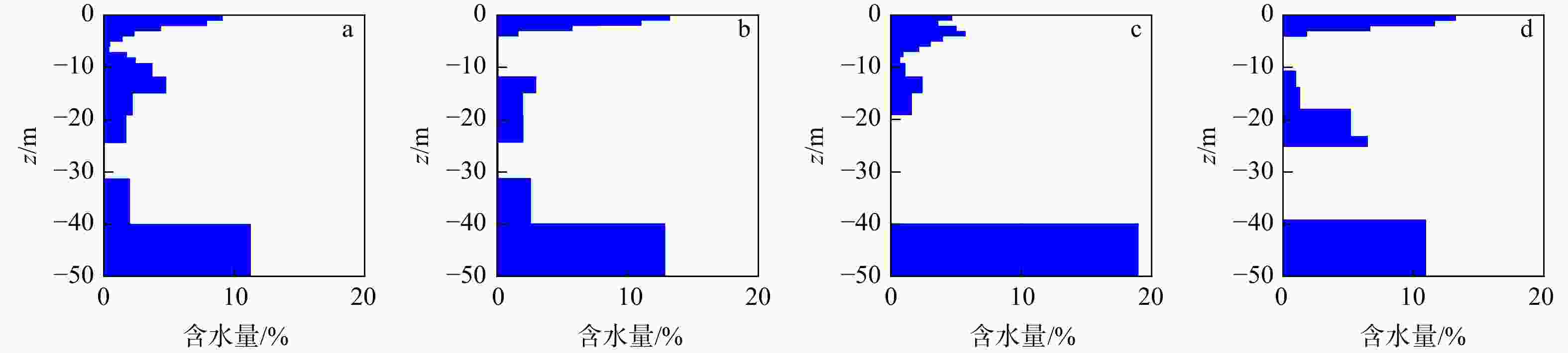
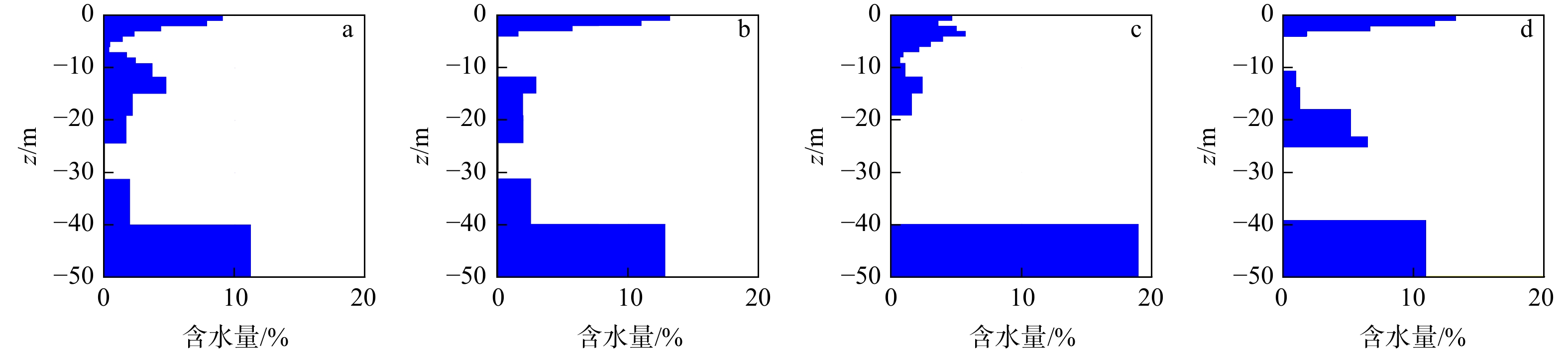
图 12 SNMR一维反演含水量直方图
a. 倾斜铺设 coil 1;b. 半倾斜铺设 coil 2;c. 半倾斜铺设 coil 3;d. 半倾斜铺设 coil 4
Figure 12. Histograms of water content from one-dimensional SNMR inversion

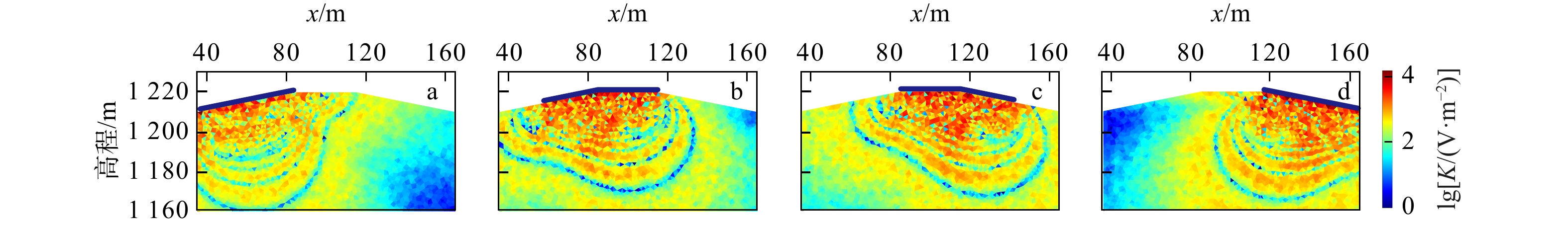
图 13 SNMR各接收线圈二维灵敏度核函数分布图
a.倾斜铺设 coil 1;b. 半倾斜铺设 coil 2;c. 半倾斜铺设 coil 3;d. 半倾斜铺设 coil 4
Figure 13. Distributions of two-dimensional sensitivity kernel functions of SNMR receiver coils
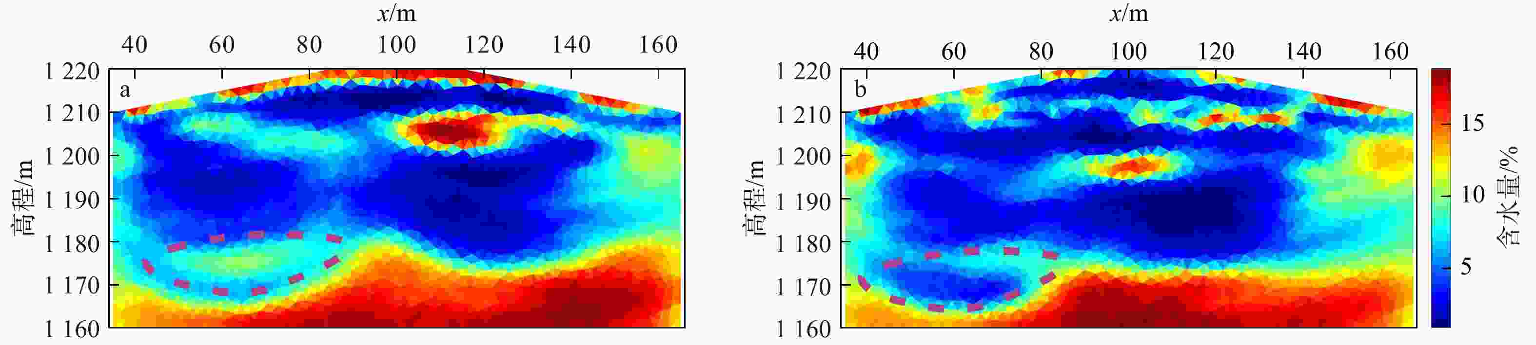
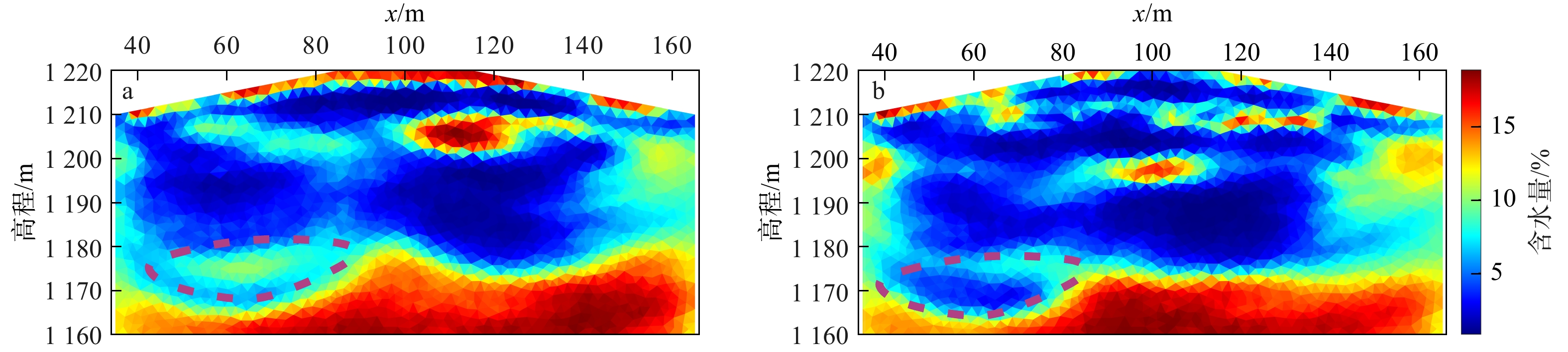
图 14 实测数据SNMR二维反演结果对比图
a. 考虑地形起伏;b. 忽略地形起伏。紫色线圈表示考虑地形起伏与忽略地形起伏2种反演结果差异显著的位置
Figure 14. Comparison of two-dimensional SNMR inversion results from measured data
表 1 场地试验过程中的地球物理参数
Table 1. Geophysical parameters during the field experiment process
参数 线圈边长/m 线圈数量/个 线圈匝数/匝 线圈类型 地磁倾角/(º) 拉莫尔频率/Hz 脉冲矩/个 叠加次数/次 数值 50 4 1 方形线圈 41.72 2066 16 64  下载: 导出CSV
-
[1] 陈紫璇, 陈云浩, 雷添杰. 中国耕地变化及耕地与水资源的匹配研究[J]. 水利水电技术, 2019, 50(2): 69-78.CHEN Z X, CHEN Y H, LEI T J. Study on variation of cultivated land and matching of cultivated land with water resources[J]. Water Resources and Hydropower Engineering, 2019, 50(2): 69-78. (in Chinese with English abstract [2] 于恒彬. 浅谈地下水资源的可持续开发利用[J]. 水上安全, 2024(13): 98-100.YU H B. Discussion on sustainable development and utilization of groundwater resources[J]. Maritime Safety, 2024(13): 98-100. (in Chinese with English abstract [3] 李宇峰. 地下水资源开发利用和保护对策研究[J]. 中国资源综合利用, 2024, 42(11): 152-154.LI Y F. Research on countermeasures of development and utilization and protection of groundwater resources[J]. China Resources Comprehensive Utilization, 2024, 42(11): 152-154. (in Chinese with English abstract [4] 孙为民. 中国水资源状况与安全分析[J]. 水利科技与经济, 2013, 19(6): 94-96. doi: 10.3969/j.issn.1004-8227.2009.02.004SUN W M. Analysis of water resources status and safety in China[J]. Water Conservancy Science and Technology and Economy, 2013, 19(6): 94-96. (in Chinese with English abstract doi: 10.3969/j.issn.1004-8227.2009.02.004 [5] 刘向东, 黄虹霖, 刘星宇, 等. 基于水槽试验的矿渣型泥石流启动特征研究: 以栾川县康山金矿区为例[J]. 西北地质, 2025, 58(1): 300-314. doi: 10.12401/j.nwg.2023194LIU X D, HUANG H L, LIU X Y, et al. Study on the starting characteristics of mine debris flow based on flume test: Taking the Kangshan gold mining area in Luanchuan County as an example[J]. Northwestern Geology, 2025, 58(1): 300-314. (in Chinese with English abstract doi: 10.12401/j.nwg.2023194 [6] 樊燏, 黄琨, 段慧毓, 等. 粤西北连州盆地构造演化对岩溶作用及岩溶塌陷的控制[J]. 地质科技通报, 2024, 43(4): 273-290. doi: 10.19509/j.cnki.dzkq.tb20230120FAN Y, HUANG K, DUAN H Y, et al. Control of tectonic evolution on karstification and karst collapse in the Lianzhou Basin, northwestern Guangdong Province[J]. Bulletin of Geological Science and Technology, 2024, 43(4): 273-290. (in Chinese with English abstract doi: 10.19509/j.cnki.dzkq.tb20230120 [7] 李振宇. 利用地面核磁共振研究滑坡地下水特征及稳定性[D]. 武汉: 中国地质大学(武汉), 2004.LI Z Y. Research on the characteristics of the groundwater and the stability of the landslide by SNMR[D]. Wuhan: China University of Geosciences(Wuhan), 2004. (in Chinese with English abstract [8] 林君. 核磁共振找水技术的研究现状与发展趋势[J]. 地球物理学进展, 2010, 25(2): 681-691. doi: 10.3969/j.issn.1004-2903.2010.02.043LIN J. Situation and progress of nuclear magnetic resonance technique for groundwater investigations[J]. Progress in Geophysics, 2010, 25(2): 681-691. (in Chinese with English abstract doi: 10.3969/j.issn.1004-2903.2010.02.043 [9] 潘玉玲, 万乐, 袁照令, 等. 核磁共振找水方法的现状和发展趋势[J]. 地质科技情报, 2000, 19(1): 105-108. doi: 10.3969/j.issn.1000-7849.2000.01.025PAN Y L, WAN L, YUAN Z L, et al. Current status and development trend of detecting underground water with nuclear magnetic resonance[J]. Geological Science and Technology Information, 2000, 19(1): 105-108. (in Chinese with English abstract doi: 10.3969/j.issn.1000-7849.2000.01.025 [10] 张荣, 胡祥云, 杨迪琨, 等. 地面核磁共振技术发展述评[J]. 地球物理学进展, 2006, 21(1): 284-289. doi: 10.3969/j.issn.1004-2903.2006.01.043ZHANG R, HU X Y, YANG D K, et al. Review of development of surface nuclear magnetic resonance[J]. Progress in Geophysics, 2006, 21(1): 284-289. (in Chinese with English abstract doi: 10.3969/j.issn.1004-2903.2006.01.043 [11] 刘燚, 康凤新, 张文强, 等. 济南长孝岩溶水系统地下水富集区补给源识别及其成因机制[J]. 地质科技通报, 2024, 43(6): 292-305.LIU Y, KANG F X, ZHANG W Q, et al. Identification and genetic mechanism of recharge sources in groundwater-rich area of Changxiao karst water system in Jinan City[J]. Bulletin of Geological Science and Technology, 2024, 43(6): 292-305. (in Chinese with English abstract [12] MAZZILLI N, CHALIKAKIS K, CARRIÈRE S D, et al. Surface nuclear magnetic resonance monitoring reveals karst unsaturated zone recharge dynamics during a rain event[J]. Water, 2020, 12(11): 3183. doi: 10.3390/w12113183 [13] 李振宇, 李俊丽, 潘玉玲. 地面核磁共振找水方法综述[J]. 勘探地球物理进展, 2002(6): 55-58.LI Z Y, LI J L, PAN Y L. Summary of groundwater detection with surface nuclear magnetic resonance method[J]. Progress in Exploration Geophysics, 2002(6): 55-58. (in Chinese with English abstract [14] 王方, 熊杰, 田慧潇, 等. 基于深度学习的大地电磁二维反演方法[J]. 地质科技通报, 2024, 43(2): 344-354.WANG F, XIONG J, TIAN H X, et al. Two-dimensional magnetotelluric inversion method based on deep learning[J]. Bulletin of Geological Science and Technology, 2024, 43(2): 344-354. (in Chinese with English abstract [15] HERTRICH M. Imaging of groundwater with nuclear magnetic resonance[J]. Progress in Nuclear Magnetic Resonance Spectroscopy, 2008, 53(4): 227-248. doi: 10.1016/j.pnmrs.2008.01.002 [16] GIRARD J F, LEGCHENKO A, BOUCHER M, et al. Numerical study of the variations of magnetic resonance signals caused by surface slope[J]. Journal of Applied Geophysics, 2008, 66(3/4): 94-103. doi: 10.1016/j.jappgeo.2008.04.003 [17] 李凡, 周明, 李开天, 等. 单斜地形情况下的磁共振测深方法反演研究[J]. 物探与化探, 2021, 45(3): 712-725. doi: 10.11720/wtyht.2021.1238LI F, ZHOU M, LI K T, et al. Inversion of magnetic resonance sounding under the condition of surface slope[J]. Geophysical and Geochemical Exploration, 2021, 45(3): 712-725. (in Chinese with English abstract doi: 10.11720/wtyht.2021.1238 [18] PODDAR M. A rectangular loop source of current on a two-layered earth[J]. Geophysical Prospecting, 1982, 30(1): 101-114. [19] 胡瑞华, 林君, 李桐林, 等. 均匀大地交变电偶极子电磁响应直接计算式[J]. 地球物理学进展, 2014, 29(5): 2183-2190. doi: 10.6038/pg20140529HU R H, LIN J, LI T L, et al. Direct calculation of the response of an electric dipole on a homogeneous earth[J]. Progress in Geophysics, 2014, 29(5): 2183-2190. (in Chinese with English abstract doi: 10.6038/pg20140529 [20] 孟永良, 罗延钟. 二维地电构造上谐变电偶极子电磁场有限元算法[C]//中国地球物理学会. 1994年中国地球物理学会第十届学术年会论文集. 北京: 地震出版社, 1994: 295.MENG Y L, LUO Y Z. Finite element algorithm for electromagnetic field of harmonic electric dipole over 2D geoelectric structure[C]//Chinese Geophysical Society. Proceedings of the 10th Annual academic meeting of the Chinese Geophysical Society, 1994. Beijing: Seismological Press, 1994: 295. (in Chinese with English abstract [21] 谢兴兵, 徐剑明, 周磊, 等. 水平低频谐变电偶极子源在地下介质中的电磁响应特征[J]. 长江大学学报(自然科学版), 2023, 20(6): 77-83.XIE X B, XU J M, ZHOU L, et al. Electromagnetic response characteristics of horizontal low-frequency harmonic electric dipole sources in underground media[J]. Journal of Yangtze University (Natural Science Edition), 2023, 20(6): 77-83. (in Chinese with English abstract [22] 赵广茂. 基于磁偶极子不规则源的瞬变电磁响应计算[J]. 铁道工程学报, 2016, 33(8): 50-54. doi: 10.3969/j.issn.1006-2106.2016.08.011ZHAO G M. The calculation of transient electromagnetic response of irregular source based on magnetic dipole[J]. Journal of Railway Engineering Society, 2016, 33(8): 50-54. (in Chinese with English abstract doi: 10.3969/j.issn.1006-2106.2016.08.011 [23] LEHMANN-HORN J A, WALBRECKER J O, HERTRICH M, et al. Imaging groundwater beneath a rugged proglacial moraine[J]. Geophysics, 2011, 76(5): 165-172. doi: 10.1190/geo2011-0095.1 [24] LEHMANN-HORN J A, HERTRICH M, GREENHALGH S A, et al. Three-dimensional magnetic field and NMR sensitivity computations incorporating conductivity anomalies and variable-surface topography[J]. IEEE Transactions on Geoscience and Remote Sensing, 2011, 49(10): 3878-3891. doi: 10.1109/TGRS.2011.2135861 [25] IRONS T, QUINN M C, LI Y G, et al. A numerical assessment of the use of surface nuclear magnetic resonance to monitor internal erosion and piping in earthen embankments[J]. Near Surface Geophysics, 2014, 12(2): 325-334. doi: 10.3997/1873-0604.2014004 [26] 詹林, 潘剑伟, 高健, 等. 基于局部加密的非结构化网格SNMR方法二维Occam反演研究[J]. 地球物理学进展, 2024, 39(3): 1089-1101.ZHAN L, PAN J W, GAO J, et al. 2-D Occam inversion study of SNMR method on unstructured grids based on local encryption[J]. Progress in Geophysics, 2024, 39(3): 1089-1101. (in Chinese with English abstract [27] 潘剑伟. 核磁共振超前探测多分量观测技术方法理论研究[D]. 武汉: 中国地质大学(武汉), 2018.PAN J W. The research on the theory and techniques of multi-components observation in NMR advanced detection[D]. Wuhan: China University of Geosciences(Wuhan), 2018. (in Chinese with English abstract [28] DANDRIDGE C, STANLEY T A, KIRSCHBAUM D B, et al. Spatial and temporal analysis of global landslide reporting using a decade of the global landslide catalog[J]. Sustainability, 2023, 15(4): 3323. doi: 10.3390/su15043323 [29] LU K, LI F, PAN J W, et al. Structural characterization and attempted displacement interpretation of the Baishuihe landslide using integrated geophysical methods[J]. Engineering Geology, 2024, 336: 107568. doi: 10.1016/j.enggeo.2024.107568 [30] 潘剑伟, 张成丽, 鲁恺, 等. SNMR联合SP用于滑动带水体赋存状态的探测研究[J]. CT理论与应用研究, 2021, 30(1): 23-34.PAN J W, ZHANG C L, LU K, et al. The combined use of surface nuclear magnetic resonance and self-potential in the research of groundwater state in the landslide[J]. Computerized Tomography Theory and Applications, 2021, 30(1): 23-34. (in Chinese with English abstract [31] KREMER T, IRONS T, MÜLLER-PETKE M, et al. Review of acquisition and signal processing methods for electromagnetic noise reduction and retrieval of surface nuclear magnetic resonance parameters[J]. Surveys in Geophysics, 2022, 43(4): 999-1053. doi: 10.1007/s10712-022-09695-3 [32] 侯彦威. TEM探测深部煤层上覆多电性层的OCCAM反演[J]. 煤田地质与勘探, 2018, 46(6): 169-173. doi: 10.3969/j.issn.1001-1986.2018.06.025HOU Y W. OCCAM inversion for detecting overlying multiple electrical layers above deep coal seams by TEM[J]. Coal Geology & Exploration, 2018, 46(6): 169-173. (in Chinese with English abstract doi: 10.3969/j.issn.1001-1986.2018.06.025 [33] 张罗磊, 于鹏, 王家林, 等. 光滑模型与尖锐边界结合的MT二维反演方法[J]. 地球物理学报, 2009, 52(6): 1625-1632. doi: 10.3969/j.issn.0001-5733.2009.06.025ZHANG L L, YU P, WANG J L, et al. Smoothest model and sharp boundary based two-dimensional magnetotelluric inversion[J]. Chinese Journal of Geophysics, 2009, 52(6): 1625-1632. (in Chinese with English abstract doi: 10.3969/j.issn.0001-5733.2009.06.025 [34] 潘玉玲, Jean BERNARD, 李振宇, 等. 轻便新型核磁共振找水仪及其在堤坝监测中的应用[J]. 大坝与安全, 2004(1): 27-29.PAN Y L, BERNARD J, LI Z Y, et al. Introduction of new hydroscope and its application to embankment monitoring[J]. Dam & Safety, 2004(1): 27-29. (in Chinese with English abstract [35] 李宏恩, 徐海峰, 李铮, 等. 地面核磁共振法与高密度电法联合探测堤坝渗漏隐患原位试验研究[J]. 地球物理学进展, 2019, 34(4): 1627-1634. doi: 10.6038/pg2019CC0249LI H E, XU H F, LI Z, et al. In situ experimental study on resistivity-magnetic resonance sounding coupling imaging diagnosis method for an embankment dam with seepage defects[J]. Progress in Geophysics, 2019, 34(4): 1627-1634. (in Chinese with English abstract doi: 10.6038/pg2019CC0249 [36] 王晓明, 崔伟, 聂栋刚. 地面核磁共振地下水探测技术在水库大坝渗漏勘查中的应用[J]. 物探与化探, 2015, 39(2): 432-436.WANG X M, CUI W, NIE D G. The application of the SNMR groundwater detection technology to the detection of reservoir dam leakage[J]. Geophysical and Geochemical Exploration, 2015, 39(2): 432-436. (in Chinese with English abstract [37] 汪国庆. 贵阳市红枫湖镇某滑坡主控因素及形成机制分析[D]. 武汉: 长江大学, 2023.WANG G Q. Analysis of formation mechanism and main controlling factors of a landslide in Hongfenghu Town, Guiyang City[D]. Wuhan: Yangtze University, 2023. (in Chinese with English abstract [38] 曹文芳, 韩翠红, 张金流, 等. 喀斯特筑坝河流表层悬浮颗粒物中磷形态的时空变化及其控制因素分析: 以贵州平寨水库和红枫湖水库为例[J]. 矿物岩石地球化学通报, 2022, 41(5): 981-991. doi: 10.19658/j.issn.1007-2802.2022.41.033CAO W F, HAN C H, ZHANG J L, et al. Spatiotemporal variations of forms of phosphorus in surface suspended particulates of the karst dammed rivers and their controlling factors: A case study of the Pingzhai reservoir and Lake Hongfeng in Guizhou Province[J]. Bulletin of Mineralogy, Petrology and Geochemistry, 2022, 41(5): 981-991. (in Chinese with English abstract doi: 10.19658/j.issn.1007-2802.2022.41.033 [39] GAO W F, SHI L Q, HAN J, et al. Dynamic monitoring of water in a working face floor using 2D electrical resistivity tomography (ERT)[J]. Mine Water and the Environment, 2018, 37(3): 423-430. doi: 10.1007/s10230-017-0483-z [40] 刘昌军, 赵进勇, 孙东亚, 等. 高密度电法仪在工程隐患探测中的应用[J]. 水利水电技术, 2007(2): 90-94.LIU C J, ZHAO J Y, SUN D Y, et al. Application of resistivity imaging systems for defect detections[J]. Water Resources and Hydropower Engineering, 2007(2): 90-94. (in Chinese with English abstract [41] 张文权, 翁爱华. 地面核磁共振正则化反演方法研究[J]. 吉林大学学报(地球科学版), 2007, 37(4): 809-813. doi: 10.13278/j.cnki.jjuese.2007.04.010ZHANG W Q, WENG A H. On regularization inversion method of surface nuclear magnetic resonance data[J]. Journal of Jilin University (Earth Science Edition), 2007, 37(4): 809-813. (in Chinese with English abstract doi: 10.13278/j.cnki.jjuese.2007.04.010 [42] 王雨春, 马梅, 万国江, 等. 贵州红枫湖沉积物磷赋存形态及沉积历史[J]. 湖泊科学, 2004, 16(1): 21-27.WANG Y C, MA M, WAN G J, et al. The phosphorus forms and depositional history in sediments of Lake Hongfeng, Guizhou Province[J]. Journal of Lake Sciences, 2004, 16(1): 21-27. (in Chinese with English abstract -

 下载:
下载:


 点击查看大图
计量
- 文章访问数: 120
- PDF下载量: 66
- 被引次数: 0

