
 投审稿入口
投审稿入口

Hydraulic tomography of typical large-scale aquifers in groundwater exploitation reduction areas of Hebei Province
-
摘要:
运用水力层析方法刻画大尺度含水层非均质性的主要困难是寻找能够显著影响区域地下水动态的刺激源,而人为控制下的地下水开采量变化无疑是一个可行的选择。选择河北地下水超采治理试点区之一的邯郸东部平原作为研究对象,利用压采所引起的地下水位响应数据开展了二维承压含水层水力层析扫描成像,探讨了不同先验信息以及观测井布局对水力参数反演效果的影响。结果表明,水力层析法能够有效刻画大尺度含水层非均质性特征,准确的地质分区信息可以明显改善参数的估计效果;相关尺度和方差对参数反演效果影响不显著;为提高含水层参数估计精度,需要充分考虑已有的先验地质信息,并结合已有水井信息,在水文地质条件明显变化区域附近补充完善地下水观测井网络。基于水力层析理念的大尺度含水层非均质性刻画方法,通过智慧式收集河北地下水压采大背景下现有井的地下水开采量和观测数据,以较低的成本刻画大尺度含水层非均质性,省去了额外的打井和抽水试验时间人力成本,具有显著的经济和社会效益。
-
关键词:
- 水力层析 /
- 先验地质信息 /
- 大尺度含水层非均质性 /
- 含水层参数 /
- 地下水压采
Abstract:ObjectiveOne of the main challenges in characterizing the heterogeneity of large-scale aquifers using hydraulic tomography is to find effective excitation sources that can significantly affect regional groundwater dynamics. Therefore, human-induced variations in groundwater exploitation amount may be a feasible option.
MethodsThe Handan Eastern Plain, one of the pilot areas for groundwater overexploitation control in Hebei Province, was selected as the study area. Hydraulic tomography was applied to a two-dimensional confined aquifer through groundwater level responses caused by exploitation reduction, and the effects of prior geological information and observation well configuration on hydraulic parameter inversion accuracy were further discussed.
ResultsThe results showed that hydraulic tomography could effectively characterize the heterogeneity of large-scale aquifers, and accurate information of geological zones could significantly improve parameter estimations. Correlation scales and variances had no significant effect on the inversion results. To improve the precision of aquifer parameter estimation, it was necessary to give full consideration to the prior geological information and existing well data, and incorporate new groundwater observation wells into the existing monitoring network in areas with significant changes in hydrogeological conditions.
ConclusionThis novel method, which characterizes the heterogeneity of large-scale aquifers based on hydraulic tomography, intelligently collects groundwater exploitation and observation data from existing wells in Hebei Province against the backdrop of groundwater exploitation reduction. Therefore, this method saves time and labor costs of additional well drilling and pumping tests, and provides remarkable economic and social benefits for mapping large-scale aquifer heterogeneity.
-

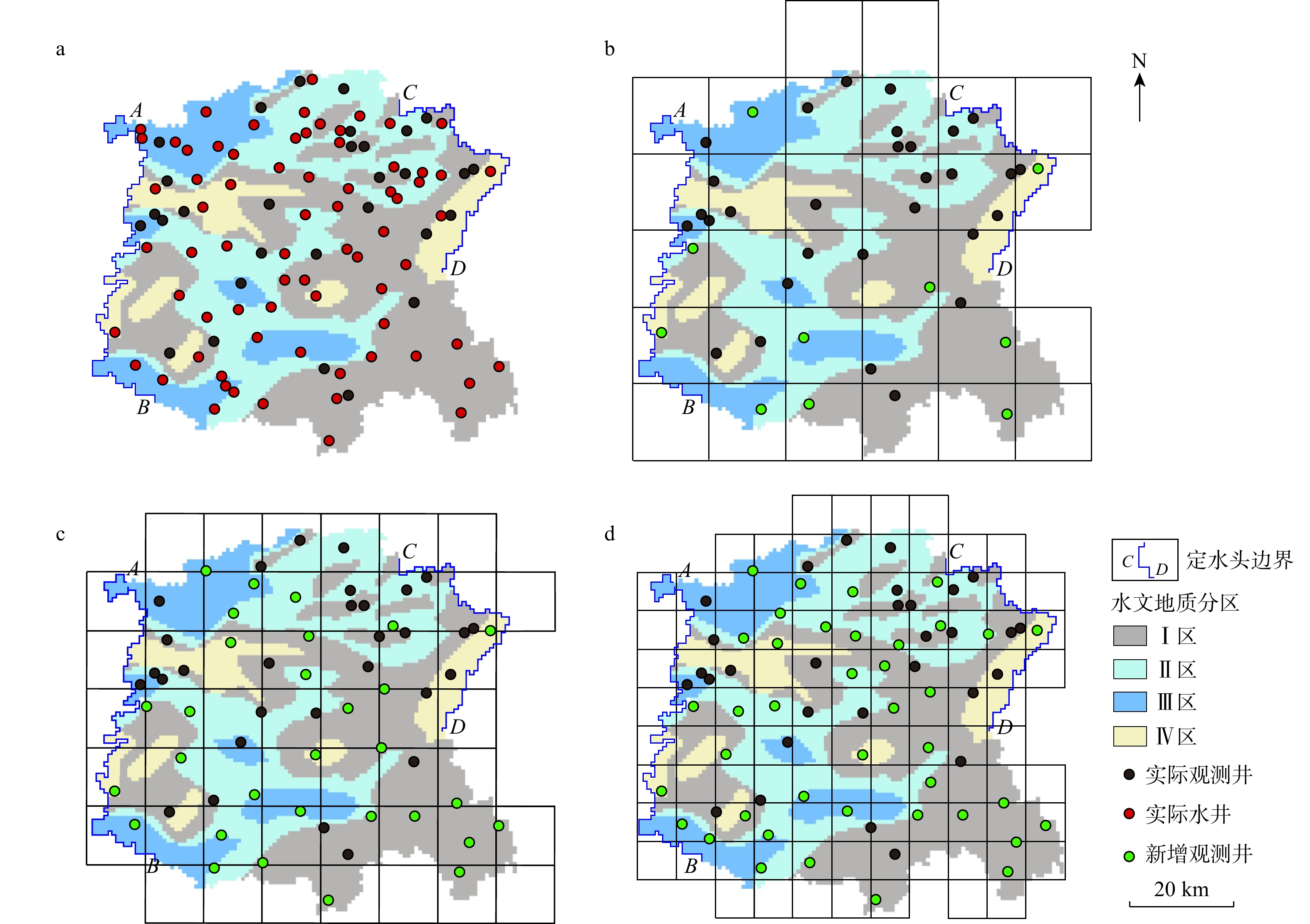
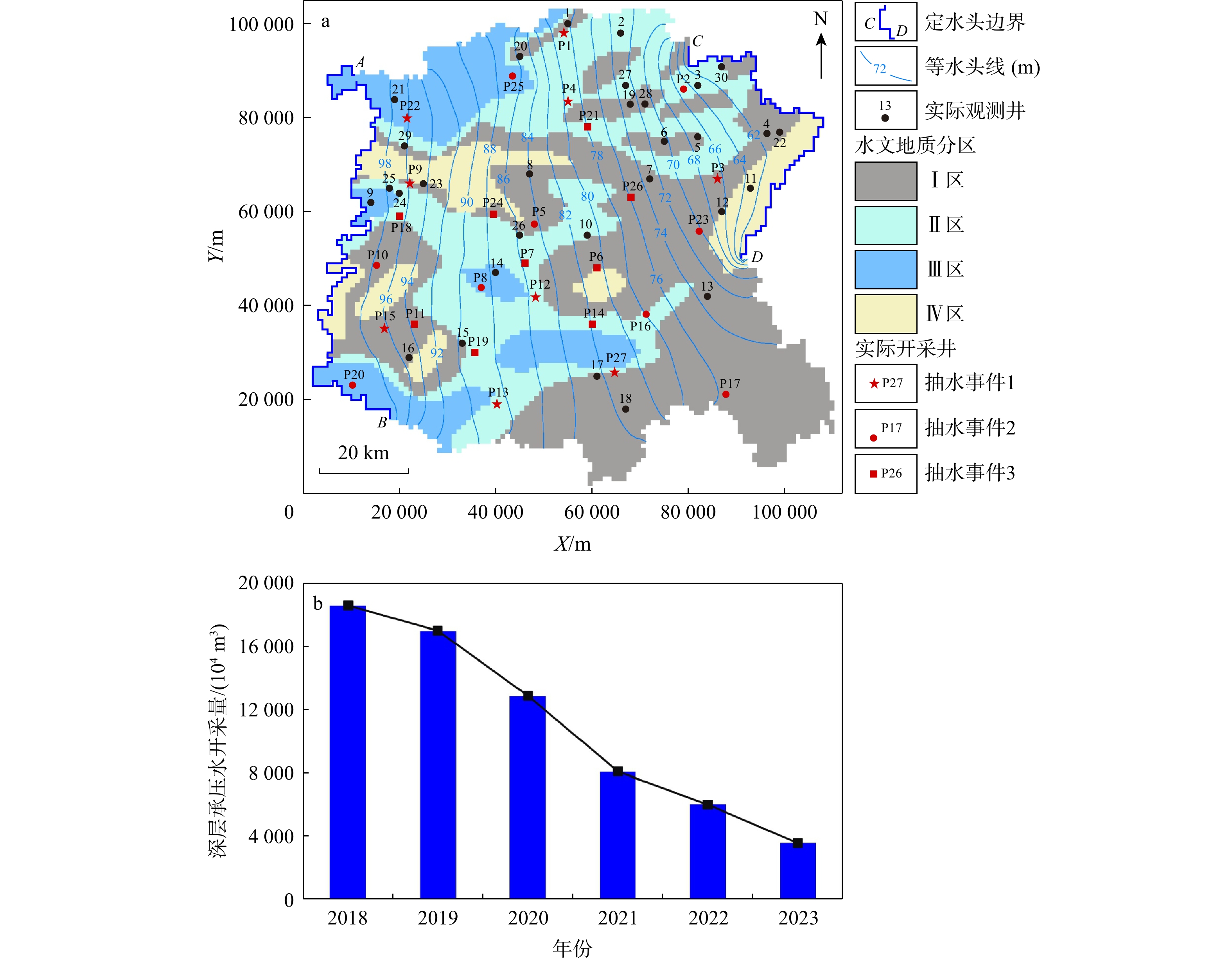
图 1 实际观测井和开采井分布、边界条件和地质分区(a)及2018—2023年研究区深层承压水开采量变化(b)
Figure 1. Distribution of observation and production wells, boundary conditions, and geological zones (a) and changes in deep confined groundwater exploitation amount from 2018 to 2023 in the study area (b)

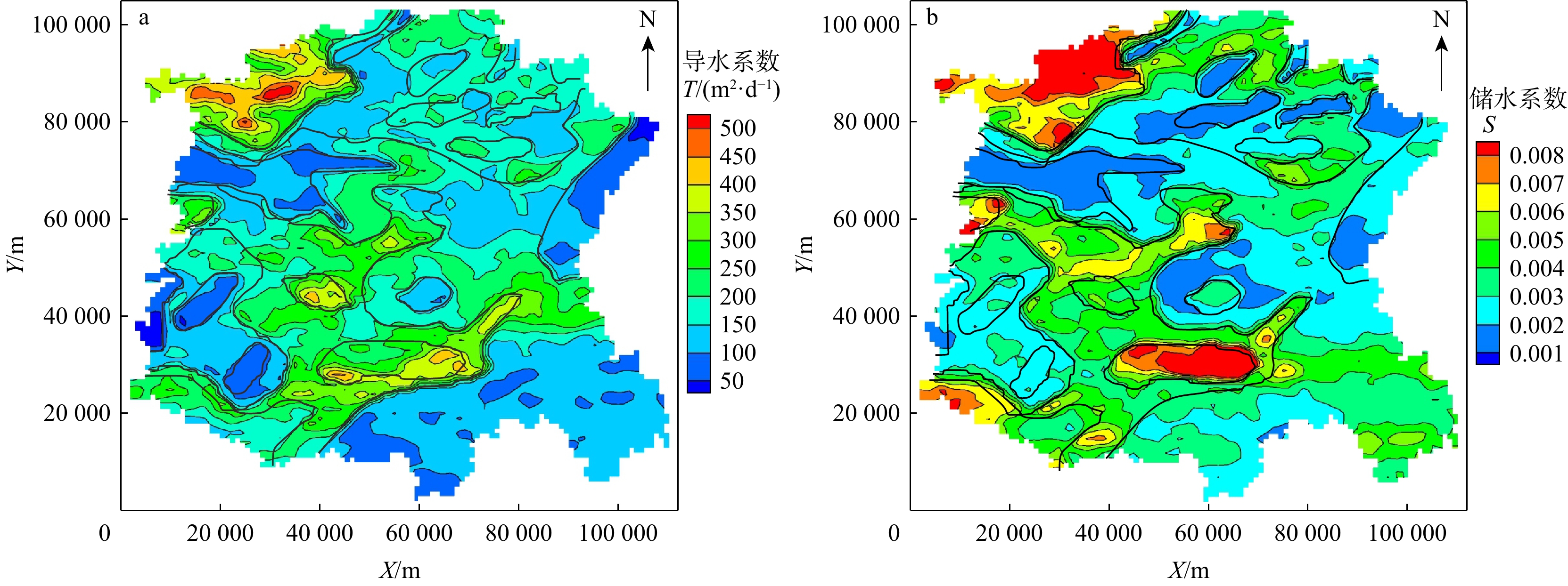
图 2 导水系数T(a)和储水系数S(b)参考场(黑色粗实线代表地质分区界线)
Figure 2. Reference fields of transmissivity T (a) and storage coefficient S (b)

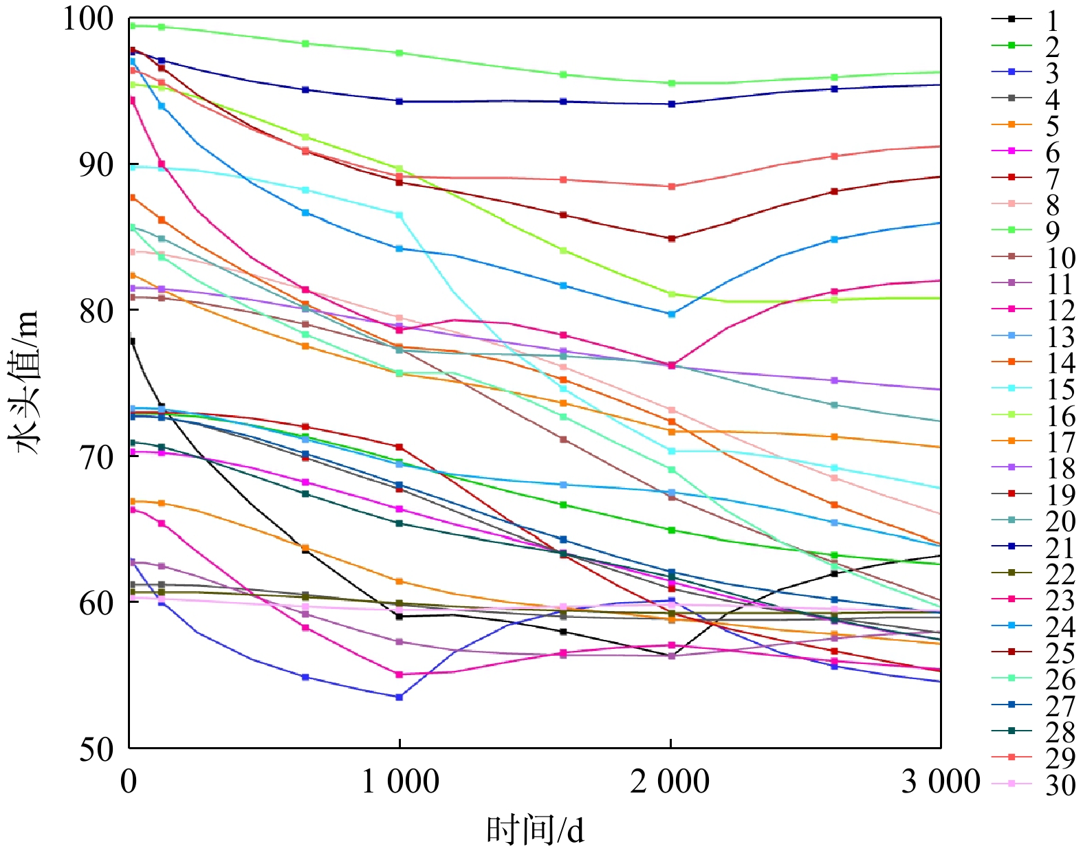
图 3 模型正演30口观测井收集的水头响应(1~30为观测井编号,观测井位见图1a)
Figure 3. Hydraulic head responses collected from 30 observation wells in model forward simulation

图 4 情景A(a~d)、情景B(e~h)和情景C(i~l)导水系数T、储水系数S估计参数场、估计值与真实值散点图
T为导水系数;S为储水系数;$ {{R}}^{\text{2}} $为相关系数;$ {{L}}_{\text{1}} $为绝对误差;$ {{L}}_{\text{2}} $为均方差;下同
Figure 4. Estimated parameter fields and scatter plots of estimated and true values of transmissivity T and storage coefficient S under scenario A (a-d), scenario B (e-h), and scenario C (i-l)

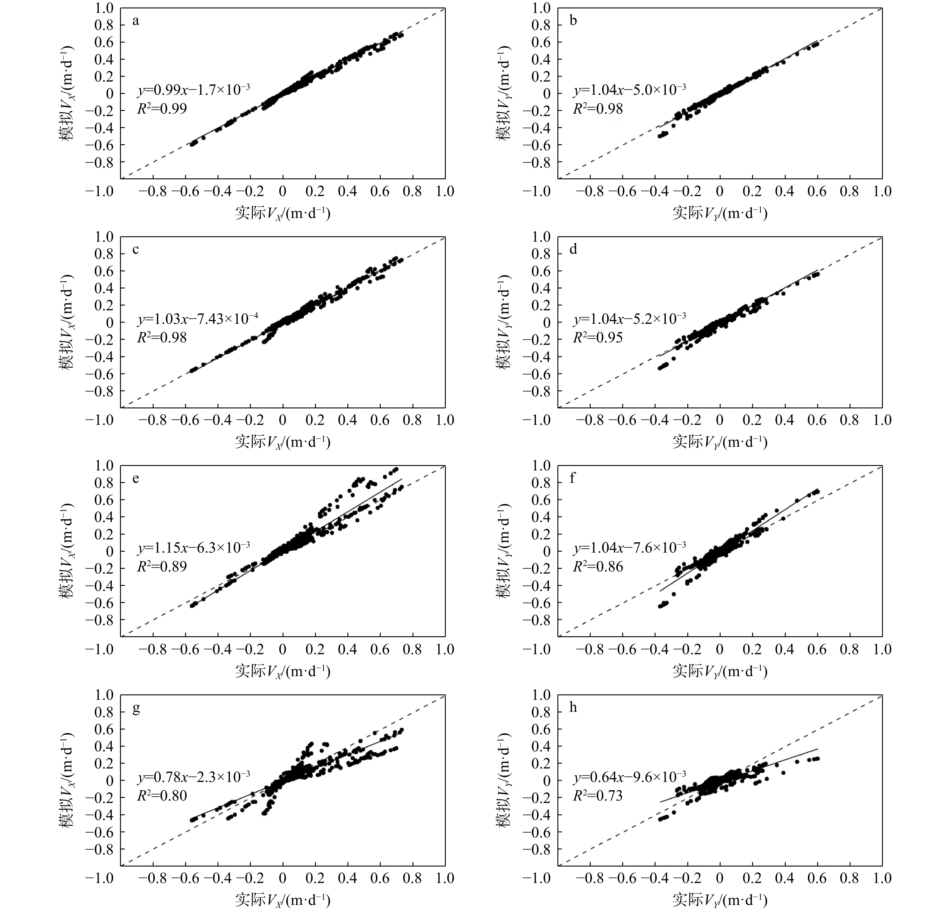
图 5 4种方案实际流速分量与模拟流速分量散点图
a,b. 方案一HT方法估计的参数场(有先验地质信息);c,d. 方案二HT方法估计的参数场(无先验地质信息);e,f. 方案三参数场为4个地质分区均值;g,h. 方案四参数场为区域Ⅰ参数均值。VX,VY分别为地下水流速在X,Y方向上的分量
Figure 5. Scatter plots of observed and simulated flow velocity under four different scenarios

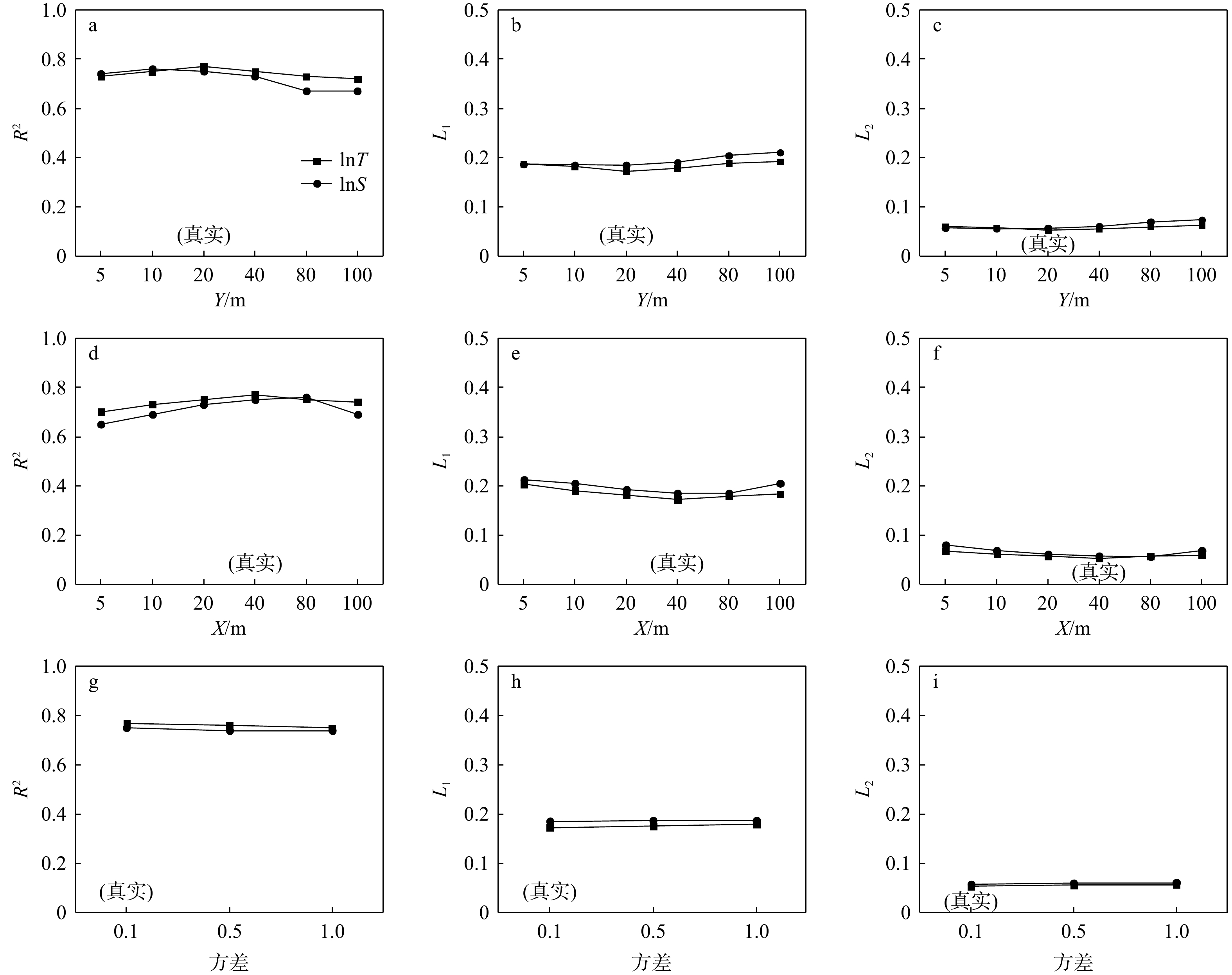
图 6 不同相关尺度和方差参数反演结果
a~c. X方向相关尺度不变,改变Y方向相关尺度;d~f. Y方向相关尺度不变,改变X方向相关尺度;g~i. lnT,lnS方差值
Figure 6. Inversion results of different correlation scales and variance parameters

图 7 观测井布局设计
a.实际水井分布位置;b.网格大小为20 km×20 km;c.网格大小为15 km×15 km;d.网格大小为10 km×10 km
Figure 7. Design of observation well configurations

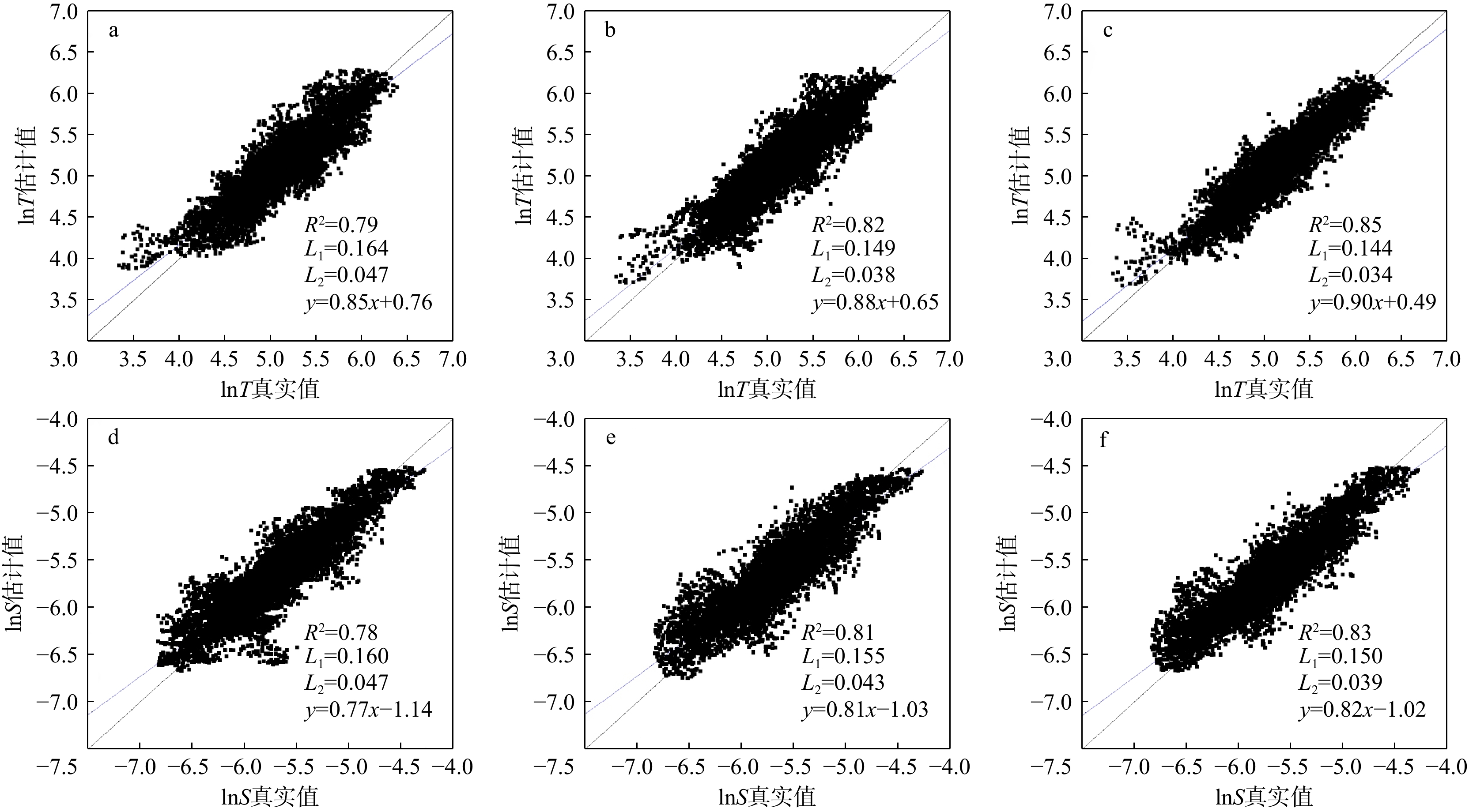
图 8 不同网格分辨率和观测井布局条件下导水系数T(a~c)和储水系数S(d~f)估计值与真实值散点图
a, d. 新增观测井10口,网格大小为20 km×20 km;b, e. 新增观测井30口,网格大小为15 km×15 km;c, f. 新增观测井40口,网格大小为10 km×10 km
Figure 8. Scatter plots of estimated and true values of transmissivity T (a-c) and storage coefficient S (d-f) under different grid resolutions and observation well configurations
表 1 非稳定流模型抽水事件(开采井位见图1a)
Table 1. Pumping events in transient flow model
抽水事件 开采井编号 开采强度/
(m3·d−1)开采时间/d 开采状态 1 P1,P3,P4,P9,P12,
P13,P15,P22,P27− 10000 [0,1 000) 正常开采 − 6000 [1 001,2 000) 减采 0 [2 001,3 000] 停采 2 P2,P5,P8,P10,P16,
P17,P20,P23,P25− 10000 [0,1 000) 正常开采 0 [1 001,2 000) 停采 − 6000 [2 001,3 000] 减采 3 P6,P7,P11,P14,P18,
P19,P21,P24,P260 [0,1 000) 停采 − 10000 [1 001,2 000) 正常开采 − 6000 [2 001,3 000] 减采  下载: 导出CSV
表 2 不同观测井布局情况下参数估计效果评价指标比较
Table 2. Comparison of performance indicators for parameter estimation under different observation well configurations
增加观测井数量/口 0 10 30 40 总观测井数量/口 30(真实) 40 60 70 lnT R2 0.77 0.79 0.82 0.85 L1 0.172 0.164 0.149 0.144 L2 0.053 0.047 0.038 0.034 斜率 0.82 0.85 0.88 0.90 截距 0.97 0.76 0.65 0.49 lnS R2 0.75 0.78 0.81 0.83 L1 0.185 0.160 0.155 0.150 L2 0.057 0.047 0.043 0.039 斜率 0.75 0.77 0.81 0.82 截距 −1.37 −1.14 −1.03 −1.02
下载: 导出CSV
-
[1] Chin-Fu Tsang, 胥思勤. 非均质介质中地下水流动与溶质运移模拟: 问题与挑战[J]. 地球科学, 2000, 25(5): 443-450.TSANG C, XU S Q. Modeling groundwater flow and mass transport in heterogeneous media: Issues and challenges[J]. Earth Science, 2000, 25(5): 443-450. (in Chinese with English abstract [2] FAKHREDDINE S, LEE J, KITANIDIS P K, et al. Imaging geochemical heterogeneities using inverse reactive transport modeling: An example relevant for characterizing arsenic mobilization and distribution[J]. Advances in Water Resources, 2016, 88: 186-197. doi: 10.1016/j.advwatres.2015.12.005 [3] 张卉, 王广才, 史浙明, 等. 基于地下水位微动态反演含水层水文地质参数研究进展[J]. 地质科技通报, 2023, 42(4): 138-146. doi: 10.19509/j.cnki.dzkq.tb20230029ZHANG H, WANG G C, SHI Z M, et al. Advances in estimation of aquifer hydrogeological parameters based on microfluctuations of groundwater level[J]. Bulletin of Geological Science and Technology, 2023, 42(4): 138-146. (in Chinese with English abstract doi: 10.19509/j.cnki.dzkq.tb20230029 [4] WU C M, JIM YEH T C, ZHU J F, et al. Traditional analysis of aquifer tests: Comparing apples to oranges?[J]. Water Resources Research, 2005, 41(9): W09402. [5] 宋刚, 万力, 胡伏生, 等. 含水层渗透性空间分布的指示克立格估值[J]. 地学前缘, 2005, 12(增刊1): 146-151.SONG G, WAN L, HU F S, et al. Indicator Kriging of spatial distribution of permeability of aquifer[J]. Earth Science Frontiers, 2005, 12(S1): 146-151. (in Chinese with English abstract [6] JIM YEH T C, LIU S Y. Hydraulic tomography: Development of a new aquifer test method[J]. Water Resources Research, 2000, 36(8): 2095-2105. doi: 10.1029/2000WR900114 [7] GOTTLIEB J, DIETRICH P. Identification of the permeability distribution in soil by hydraulic tomography[J]. Inverse Problems, 1995, 11(2): 353-360. doi: 10.1088/0266-5611/11/2/005 [8] BOHLING G C, ZHAN X Y, BUTLER JR J J, et al. Steady shape analysis of tomographic pumping tests for characterization of aquifer heterogeneities[J]. Water Resources Research, 2002, 38(12): 60-1-60-15. doi: 10.1029/2001wr001176 [9] ZHAO Z F, ILLMAN W A, ZHA Y Y, et al. Transient hydraulic tomography analysis of fourteen pumping tests at a highly heterogeneous multiple aquifer-aquitard system[J]. Water, 2019, 11(9): 1864. doi: 10.3390/w11091864 [10] 郝永红, 叶天齐, 韩宝平, 等. 运用水力层析法对含水层裂隙带成像[J]. 水文地质工程地质, 2008, 35(6): 6-11. doi: 10.3969/j.issn.1000-3665.2008.06.003HAO Y H, YE T Q, HAN B P, et al. Imaging fracture connectivity using hydraulic tomography[J]. Hydrogeology & Engineering Geology, 2008, 35(6): 6-11. (in Chinese with English abstract doi: 10.3969/j.issn.1000-3665.2008.06.003 [11] MAO D Q, JIM YEH T C, WAN L, et al. Joint interpretation of sequential pumping tests in unconfined aquifers[J]. Water Resources Research, 2013, 49(4): 1782-1796. doi: 10.1002/wrcr.20129 [12] 王文梅, 孙蓉琳. 水力层析法刻画非均质含水层K与S采样时间优化设计[J]. 地质科技情报, 2015, 34(3): 165-170.WANG W M, SUN R L. Optimal design of sampling time using hydraulic tomography to characterize the heterogeneous aquifer hydraulic conductivity and storage coefficient[J]. Geological Science and Technology Information, 2015, 34(3): 165-170. (in Chinese with English abstract [13] LIU S Y, JIM YEH T C, GARDINER R. Effectiveness of hydraulic tomography: Sandbox experiments[J]. Water Resources Research, 2002, 38(4): 5-1-5-9. [14] ILLMAN W A, CRAIG A J, LIU X Y. Practical issues in imaging hydraulic conductivity through hydraulic tomography[J]. Groundwater, 2008, 46(1): 120-132. doi: 10.1111/j.1745-6584.2007.00374.x [15] ILLMAN W A, BERG S J, LIU X Y, et al. Hydraulic, partitioning tracer tomography for DNAPL source zone characterization: Small-scale sandbox experiments[J]. Environmental Science & Technology, 2010, 44(22): 8609-8614. doi: 10.1021/es101654j [16] 蒋立群, 孙蓉琳, 王文梅, 等. 水力层析法与克里金法估算非均质含水层渗透系数场比较[J]. 地球科学, 2017, 42(2): 307-314.JIANG L Q, SUN R L, WANG W M, et al. Comparison of hydraulic tomography and Kriging for estimating hydraulic conductivity of a heterogeneous aquifer[J]. Earth Science, 2017, 42(2): 307-314. (in Chinese with English abstract [17] 蒋立群, 孙蓉琳, 梁杏. 含水层非均质性不同刻画方法对地下水流和溶质运移预测的影响[J]. 地球科学, 2021, 46(11): 4150-4160.JIANG L Q, SUN R L, LIANG X. Predicting groundwater flow and transport in heterogeneous aquifer sandbox using different parameter estimation methods[J]. Earth Science, 2021, 46(11): 4150-4160. (in Chinese with English abstract [18] ILLMAN W A, LIU X Y, TAKEUCHI S, et al. Hydraulic tomography in fractured granite: Mizunami underground research site, Japan[J]. Water Resources Research, 2009, 45(1): W01406. [19] BERG S J, ILLMAN W A. Three-dimensional transient hydraulic tomography in a highly heterogeneous glaciofluvial aquifer-aquitard system[J]. Water Resources Research, 2011, 47(10): W10507. [20] 赵瑞珏, 毛德强, 刘再斌, 等. 基于水力层析法的某煤矿承压含水层叠加放水试验分析[J]. 水文地质工程地质, 2021, 48(1): 1-9.ZHAO R J, MAO D Q, LIU Z B, et al. An analysis of sequential water releasing tests of the confined aquifers in a coal mine based on hydraulic tomography[J]. Hydrogeology & Engineering Geology, 2021, 48(1): 1-9. (in Chinese with English abstract [21] 吴双红, 刘泉, 戚俊杰, 等. 基于水力走时反演刻画裂隙含水层非均质性[J]. 地质科技通报, 2021, 40(1): 175-183.WU S H, LIU Q, QI J J, et al. Characterization of the heterogeneity of a fractured aquifer based on hydraulic travel time inversion[J]. Bulletin of Geological Science and Technology, 2021, 40(1): 175-183. (in Chinese with English abstract [22] JIM YEH T C, LEE C H, HSU K C, et al. A view toward the future of subsurface characterization: CAT scanning groundwater basins[J]. Water Resources Research, 2008, 44(3): W03301. doi: 10.1029/2007wr006375 [23] MAO D Q, LIU Z B, WANG W K, et al. An application of hydraulic tomography to a deep coal mine: Combining traditional pumping tests with water inrush incidents[J]. Journal of Hydrology, 2018, 567: 1-11. doi: 10.1016/j.jhydrol.2018.09.058 [24] ZHA Y Y, JIM YEH T C, ILLMAN W A, et al. Exploitation of pump-and-treat remediation systems for characterization of hydraulic heterogeneity[J]. Journal of Hydrology, 2019, 573: 324-340. doi: 10.1016/j.jhydrol.2019.03.089 [25] LUO N, ILLMAN W A, ZHA Y Y, et al. Three-dimensional hydraulic tomography analysis of long-term municipal wellfield operations: Validation with synthetic flow and solute transport data[J]. Journal of Hydrology, 2020, 590: 125438. doi: 10.1016/j.jhydrol.2020.125438 [26] LIU F, JIM YEH T C, WANG Y L, et al. Characterization of basin-scale aquifer heterogeneity using transient hydraulic tomography with aquifer responses induced by groundwater exploitation reduction[J]. Journal of Hydrology, 2020, 588: 125137. doi: 10.1016/j.jhydrol.2020.125137 [27] LIU F, JIM YEH T C, SONG X F, et al. Temporal sampling and role of flux measurements for subsurface heterogeneous characterization in groundwater basins using hydraulic tomography[J]. Hydrological Processes, 2021, 35(8): e14299. doi: 10.1002/hyp.14299 [28] 汪泉娟, 孙敬锋, 杨英杰, 等. 克里金方法与深度学习方法用于浅层地下水位估计的对比研究: 以深汕特别合作区为例[J]. 地质科技通报, 2024, 43(4): 291-301.WANG Q J, SUN J F, YANG Y J, et al. A comparative study of Kriging and deep learning methods for shallow groundwater level estimation: A case study of the Shenzhen-Shanwei Special Cooperation Zone[J]. Bulletin of Geological Science and Technology, 2024, 43(4): 291-301. (in Chinese with English abstract [29] 杨会峰, 曹文庚, 支传顺, 等. 近40年来华北平原地下水位演变研究及其超采治理建议[J]. 中国地质, 2021, 48(4): 1142-1155. doi: 10.12029/gc20210411YANG H F, CAO W G, ZHI C S, et al. Evolution of groundwater level in the North China Plain in the past 40 years and suggestions on its overexploitation treatment[J]. Geology in China, 2021, 48(4): 1142-1155. (in Chinese with English abstract doi: 10.12029/gc20210411 [30] 张兆吉, 费宇红, 郭春艳, 等. 华北平原区域地下水污染评价[J]. 吉林大学学报(地球科学版), 2012, 42(5): 1456-1461.ZHANG Z J, FEI Y H, GUO C Y, et al. Regional groundwater contamination assessment in the North China Plain[J]. Journal of Jilin University (Earth Science Edition), 2012, 42(5): 1456-1461. (in Chinese with English abstract [31] 李文鹏, 王龙凤, 杨会峰, 等. 华北平原地下水超采状况与治理对策建议[J]. 中国水利, 2020(13): 26-30. doi: 10.3969/j.issn.1000-1123.2020.13.017LI W P, WANG L F, YANG H F, et al. The groundwater overexploitation status and countermeasure suggestions of the North China Plain[J]. China Water Resources, 2020(13): 26-30. (in Chinese with English abstract doi: 10.3969/j.issn.1000-1123.2020.13.017 [32] XIANG J W, JIM YEH T C, LEE C H, et al. A simultaneous successive linear estimator and a guide for hydraulic tomography analysis[J]. Water Resources Research, 2009, 45(2): W02432. doi: 10.1029/2008wr007180 [33] 张士杰, 黄智华. 华北平原邯郸地区地下水位动态及成因分析[J]. 人民黄河, 2019, 41(增刊2): 25-27.ZHANG S J, HUANG Z H. Dynamic and cause analysis of groundwater level in Handan area of North China Plain[J]. Yellow River, 2019, 41(S2): 25-27. (in Chinese with English abstract [34] 张韧. 滏阳河流域邯郸段浅层地下水化学特征及可更新能力评价[D]. 河北邯郸: 河北工程大学, 2021.ZHANG R. Chemical characteristics and renewable capacity evaluation of shallow groundwater in the Handan section of the Fuyang River basin[D]. Handan Hebei: Hebei University of Engineering, 2021. (in Chinese with English abstract [35] 邹嘉文. 黑龙港典型压采区地下水水化学变化特征及影响因素研究[D]. 河北邯郸: 河北工程大学, 2022.ZOU J W. Characteristics and controlling factors of groundwater chemistry change in typical groundwater exploitation reduction area of Heilonggang[D]. Handan Hebei: Hebei University of Engineering, 2022. (in Chinese with English abstract [36] 孙健. 基于MODFLOW的邯郸市东部平原区地下水数值模拟研究[D]. 北京: 中国地质大学(北京), 2017.SUN J. Numerical simulation study of groundwater in eastern plain of Handan based on MODFLOW[D]. Beijing: China University of Geosciences(Beijing), 2017. (in Chinese with English abstract [37] 魏瑞均. 漳卫河流域平原区地下水资源评价及典型地段地表水与地下水转化关系研究[D]. 北京: 中国地质大学(北京), 2018.WEI R J. Evaluation of groundwater resources in plain area of Zhangwei River basin and relationship between surface water and groundwater conversion in typical section[D]. Beijing: China University of Geosciences(Beijing), 2018. (in Chinese with English abstract [38] 石建省, 李国敏, 梁杏, 等. 华北平原地下水演变机制与调控[J]. 地球学报, 2014, 35(5): 527-534. doi: 10.3975/cagsb.2014.05.01SHI J S, LI G M, LIANG X, et al. Evolution mechanism and control of groundwater in the North China Plain[J]. Acta Geoscientica Sinica, 2014, 35(5): 527-534. (in Chinese with English abstract doi: 10.3975/cagsb.2014.05.01 [39] 崔莉红, 成建梅, 路万里, 等. 弱透水层低速非达西流咸水下移过程的模拟研究[J]. 水利学报, 2014, 45(7): 875-882. doi: 10.13243/j.cnki.slxb.2014.07.015CUI L H, CHENG J M, LU W L, et al. Numerical study on saltwater downward migration in aquitard as low velocity non-Darcy flow[J]. Journal of Hydraulic Engineering, 2014, 45(7): 875-882. (in Chinese with English abstract doi: 10.13243/j.cnki.slxb.2014.07.015 [40] KUHLMAN K L, HINNELL A C, MISHRA P K, et al. Basin-scale transmissivity and storativity estimation using hydraulic tomography[J]. Groundwater, 2008, 46(5): 706-715. doi: 10.1111/j.1745-6584.2008.00455.x -

 下载:
下载:


 点击查看大图
计量
- 文章访问数: 742
- PDF下载量: 145
- 被引次数: 0

