
 投审稿入口
投审稿入口

Collapse and landslide risk assessment based on machine learning improved IVM-RF coupling method:A case study of Zhidan County,Yan'an City
-
摘要:
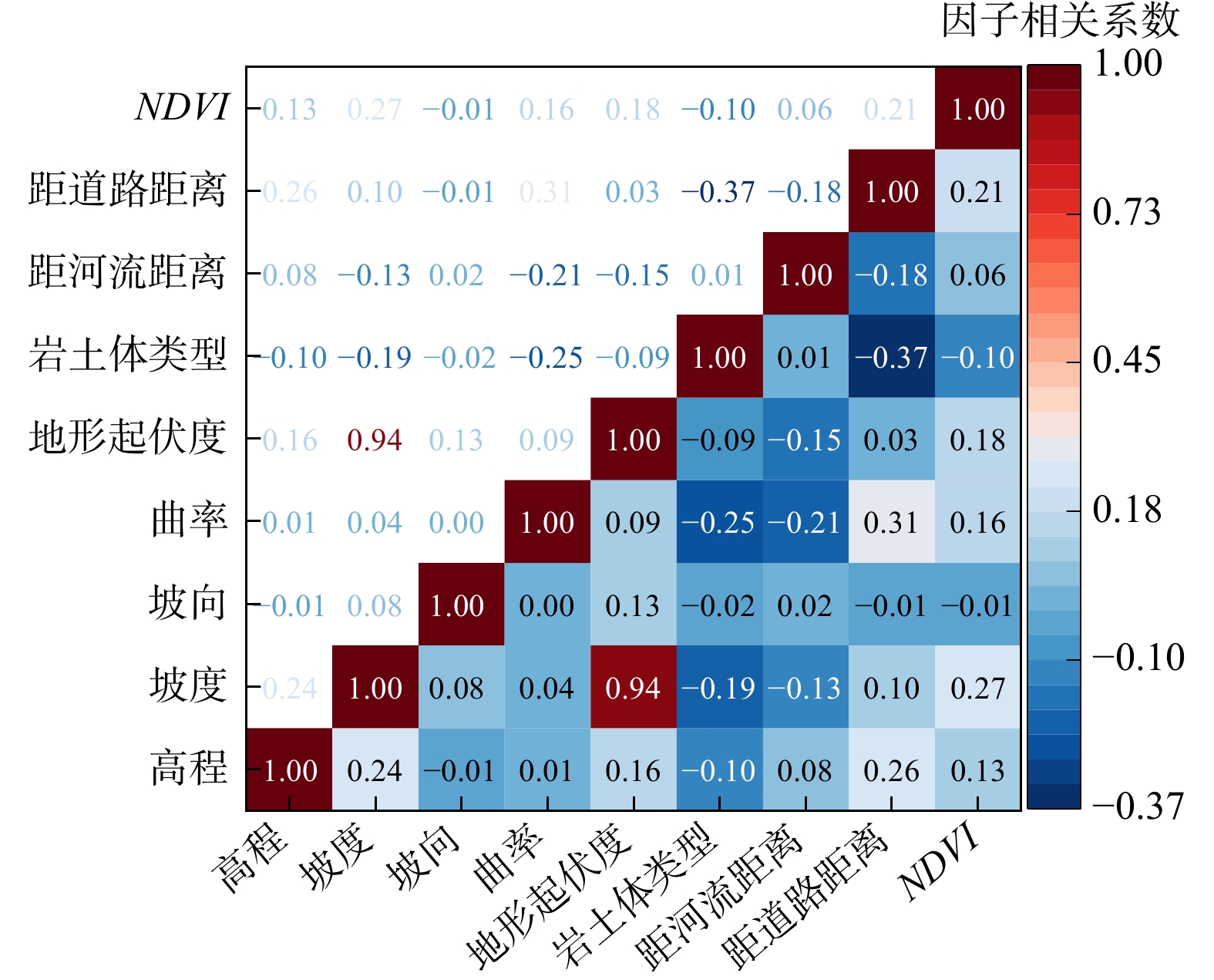
为了给延安市志丹县防灾减灾和风险管控提供数据支持,给相似地区危险性评价提供参考依据,补充在崩塌和滑坡灾害危险性评价中未考虑累积降雨方面的影响,在10,20,50和100 a一遇4种不同降雨工况下对研究区进行了危险性评价。以栅格单元作为评价单元,结合灾害特征及区域孕灾背景,通过皮尔逊相关系数法,选取高程、坡度、坡向、曲率、岩土体类型、距河流距离、距道路距离、归一化植被指数8个评价因子,采用信息量模型进行了易发性评价并分析了致灾因子与灾害分布关联性。利用计算机语言,自动处理前期因子数据的分析、转化、管理和出图等流程,改进了信息量(IVM)−随机森林(RF)耦合模型,实现了模型的自动循环迭代对比选择,通过ROC(受试者工作特征曲线,receiver operating characteristic curve)曲线对比了2种易发性模型精度。在耦合模型评价结果的基础上进行危险性评价,用皮尔逊Ⅲ型曲线估算研究区10,20,50和100 a一遇4种不同工况下降雨量,并进行危险性分区。对于易发性分区结果,信息量−随机森林耦合模型评价结果的
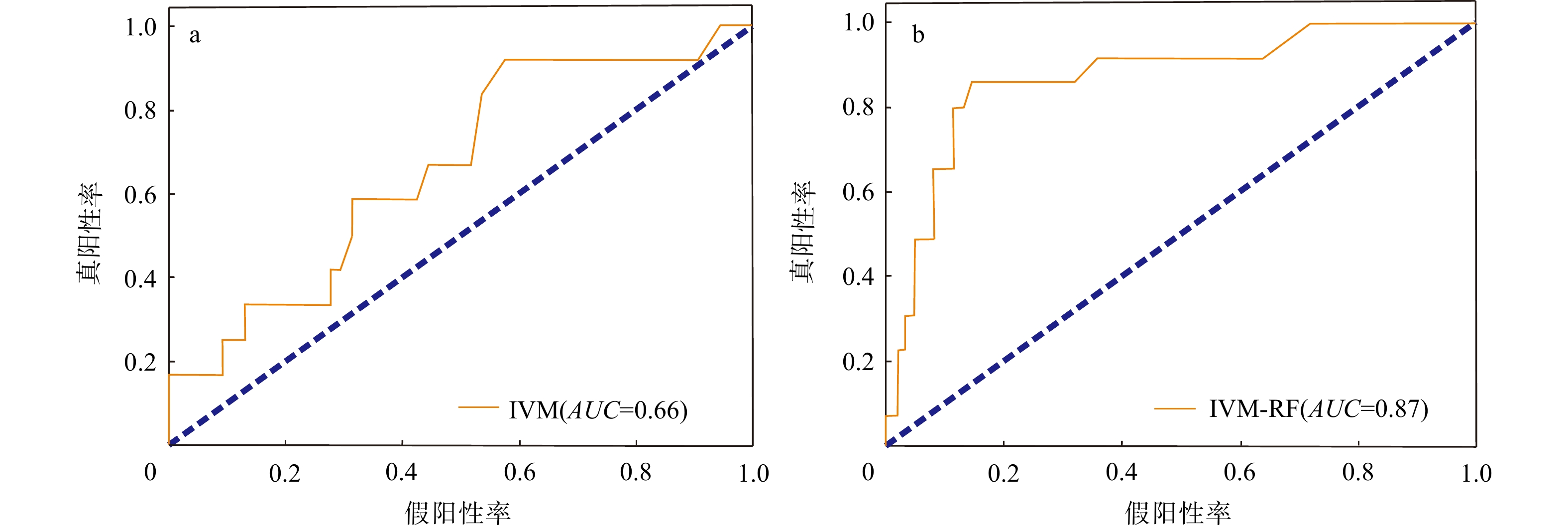
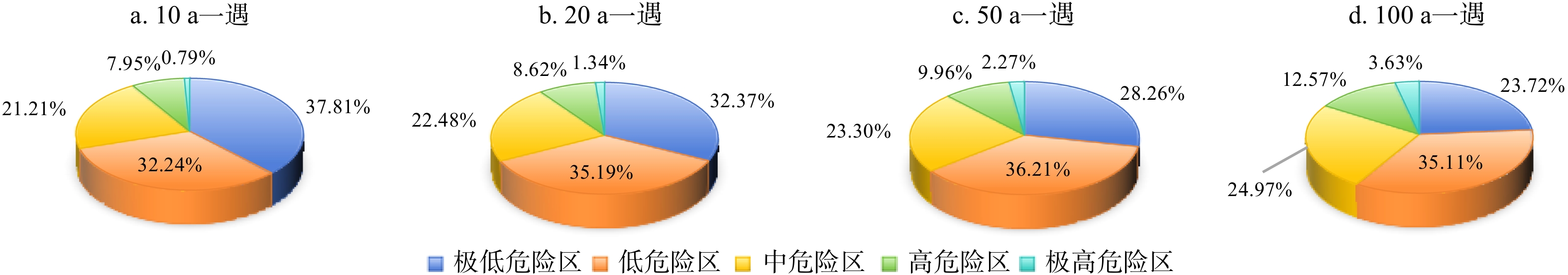
AUC 值(ROC曲线下面积)为0.87,优于IVM模型的评价结果;对于危险性分区结果,从10 a一遇到100 a一遇降雨工况的高和极高危险区面积都逐级增加。研究表明,改进的耦合模型评价方法不仅简化了操作还提高了精度,耦合模型确实拥有更好的评价精度和预测能力。-
关键词:
- 崩塌 /
- 滑坡 /
- 信息量(IVM)模型 /
- 随机森林(RF)模型 /
- 危险性评价 /
- 机器学习 /
- 延安市志丹县
Abstract:ObjectiveTo provide data support for disaster prevention, mitigation and risk management in Zhidan County, while providing reference for risk assessment in similar regions and addressing the research gap in collapse and landslide risk assessment that neglects cumulative rainfall impacts, this study conducted risk assessment under four different rainfall conditions: 10, 20, 50 and 100 years recurrence intervals.
MethodsUsing Zhidan County as the study area with grid unit as evaluation element, we selected eight evaluation factors through Pearson correlation coefficient method: elevation, slope, aspect, curvature, rock/soil type, distance to river, distance to roads, and normalized vegetation index. The information model (IVM) was employed to evaluate the susceptibility and analyze the correlations between causative factors and disaster distribution. Through programming implementation, the analysis, transformation, management and drawing of the previous factor data are automatically processed, the IVM-RF (random forest) coupled model is improved, and the automatic cycle iteration comparison selection of the model is realized. The accuracy of the two susceptibility models is compared by ROC curve. Based on the evaluation results of the coupled model, the risk assessment was carried out. The Pearson type Ⅲ curve was used to estimate the rainfall in the study area under four different conditions of 10, 20, 50 and 100 years, and the risk zoning was carried out.
ResultsFor the results of susceptibility zoning, the
AUC value of the evaluation results of the information-random forest coupling model is 0.87, which is better than the evaluation results of IVM. For the results of risk zoning, the area of high and extremely high-risk areas have gradually increased from 10 to 100 years. The improved coupled model evaluation method not only simplifies the operation but also improves the accuracy.ConclusionAccording to the survey results, the coupled model does have better evaluation accuracy and prediction ability.
-
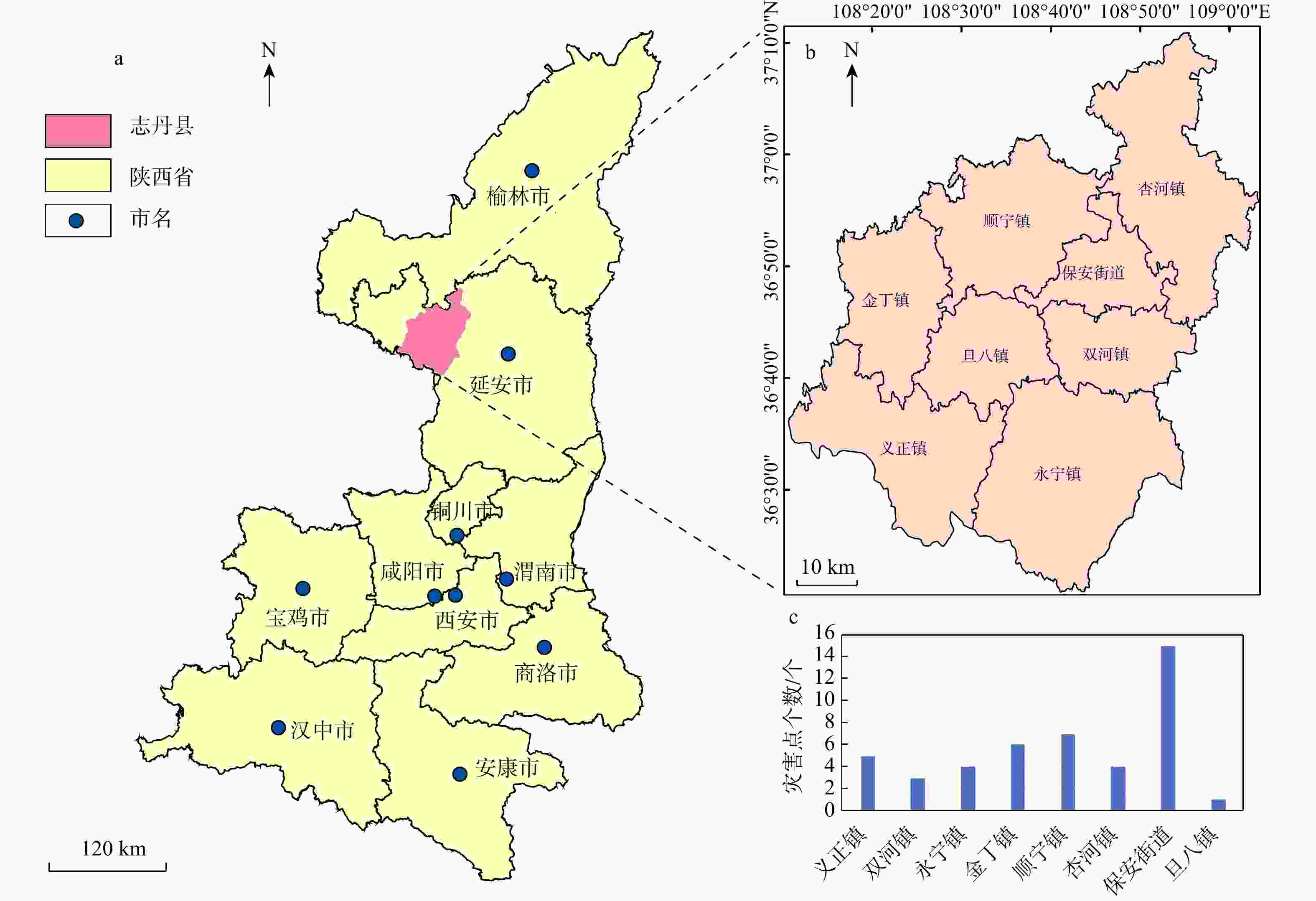
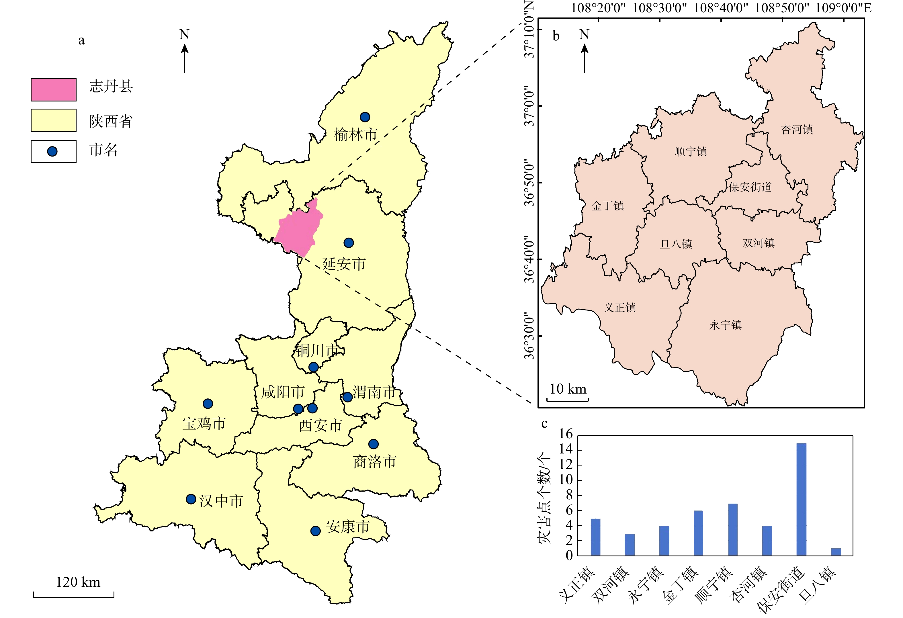
图 1 延安市志丹县地理位置示意图(a,b)及乡镇灾害点数量图(c)
Figure 1. Geographical location (a, b) of Zhidan County,Yan'an City and distribution of disaster sites in townships (c)
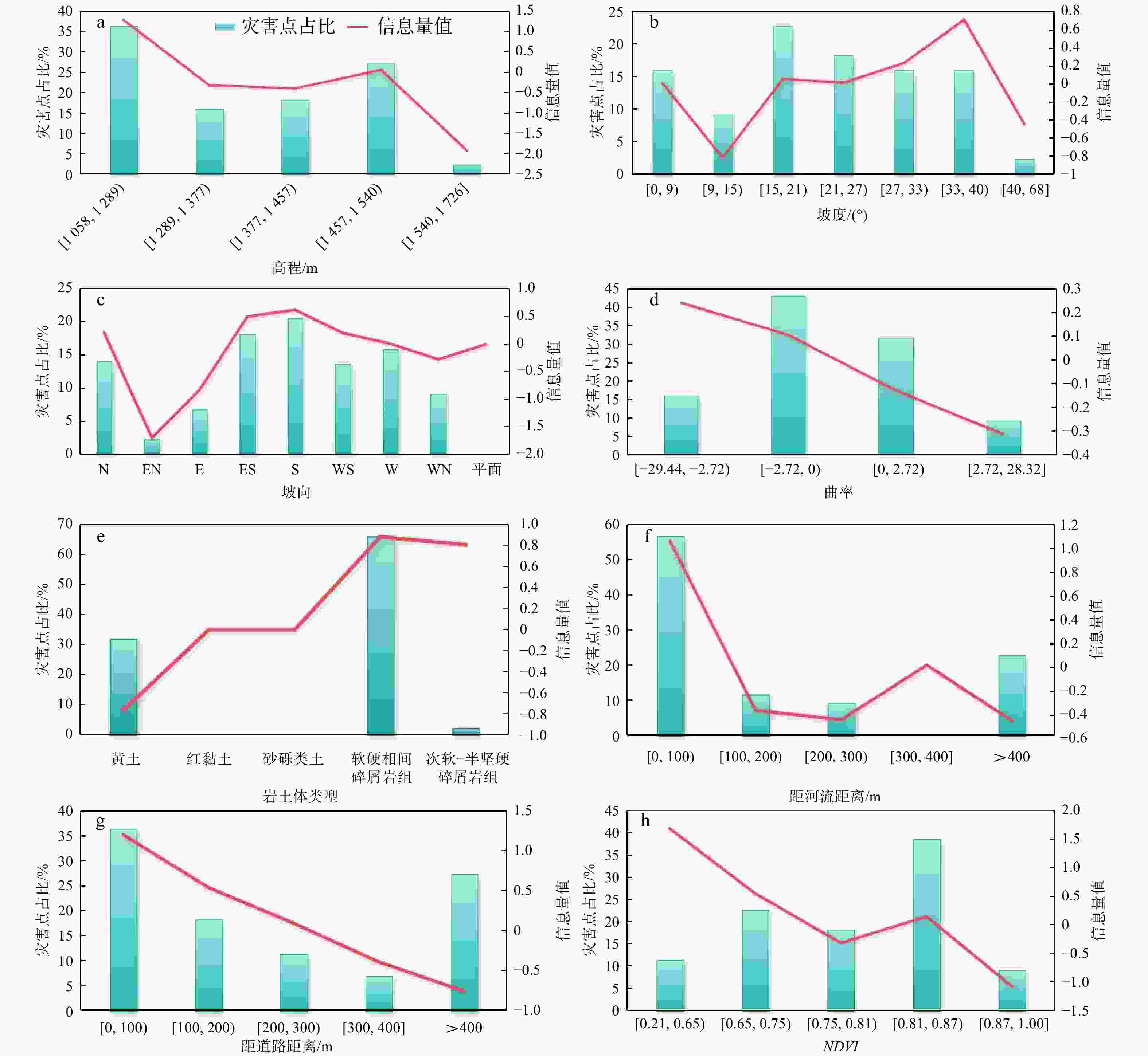
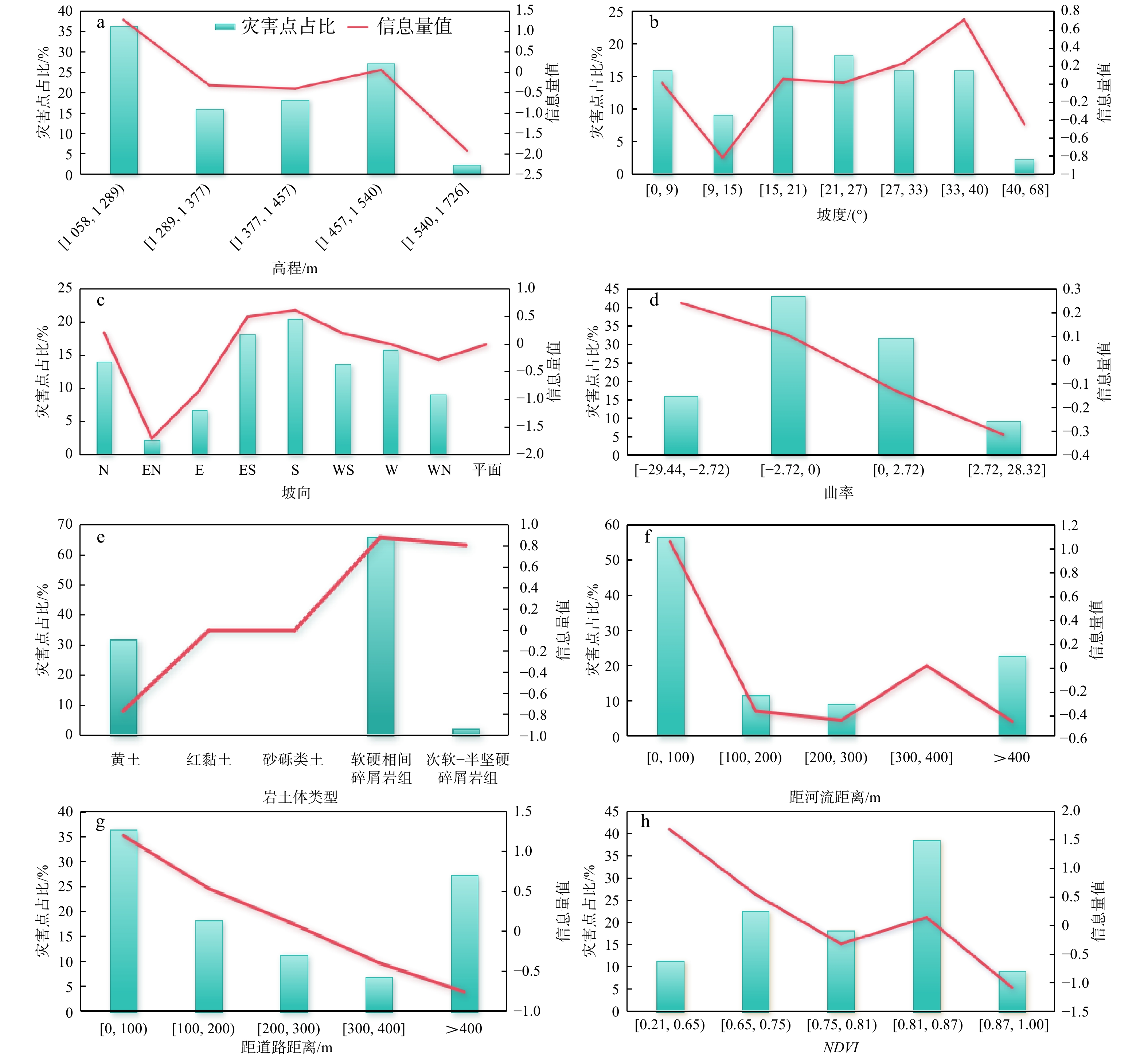
图 7 各因子分级信息量值与灾害点占比图
Figure 7. Information values and disaster point ratio of factor classifications

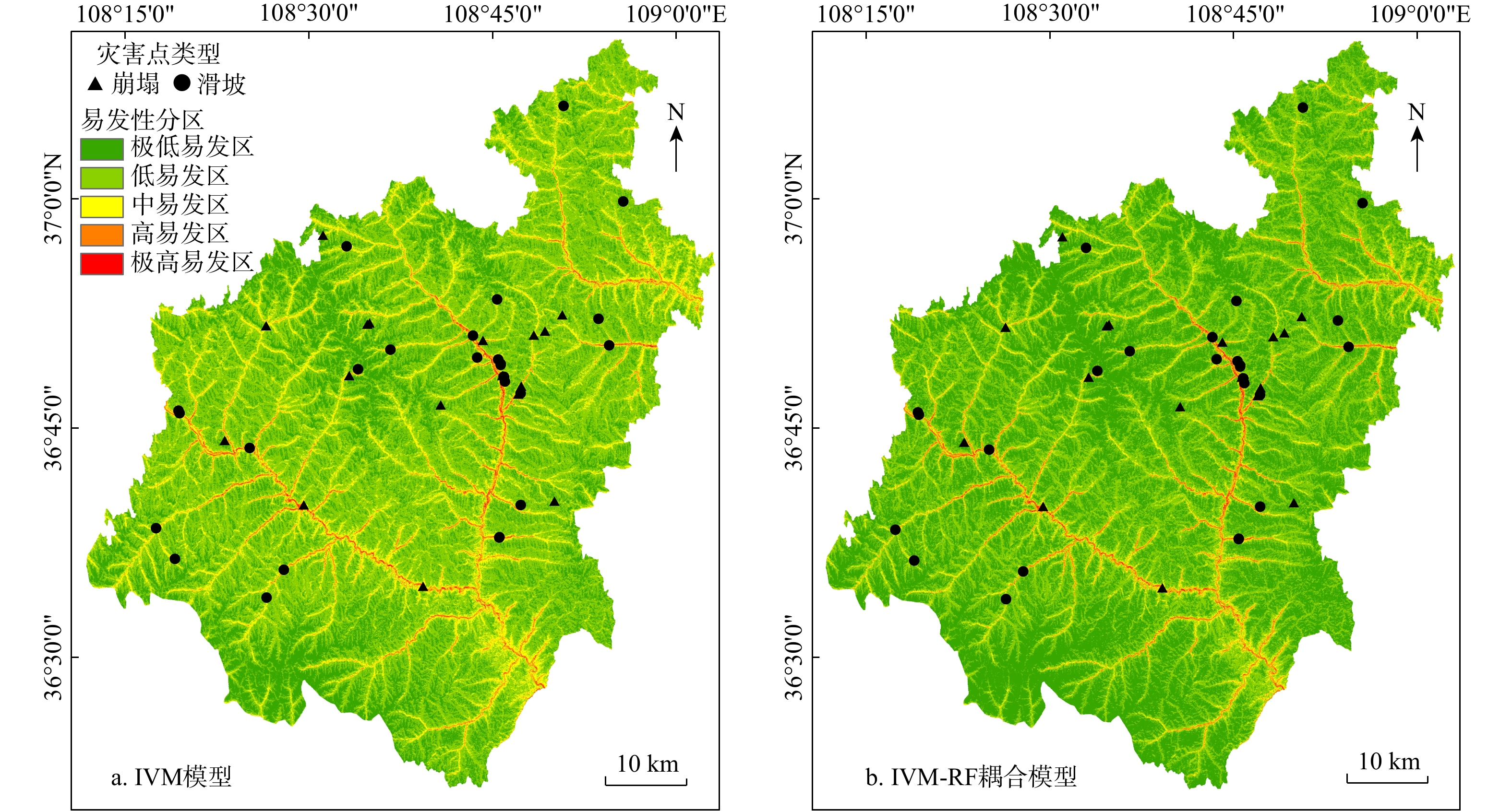
图 9 IVM模型(a)和IVM-RF耦合模型(b)的崩滑易发性分区图
Figure 9. Landslide susceptibility zoning of IVM model (a) and IVM-RF coupled model (b)
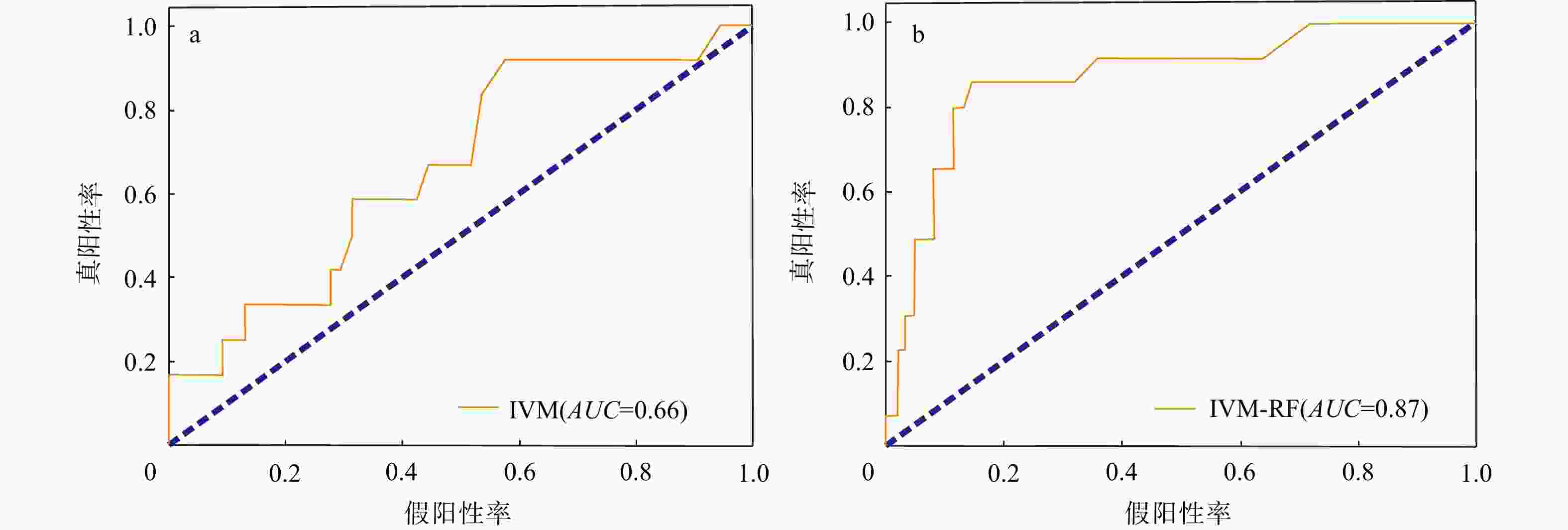
图 10 IVM模型(a)和IVM-RF耦合模型(b)的ROC曲线图(AUC为ROC曲线下面积)
Figure 10. ROC curves of IVM model (a) and IVM-RF coupled model (b)
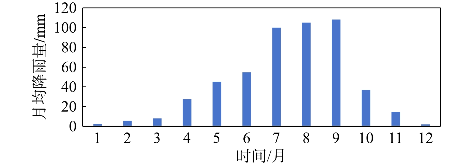
图 11 2001−2022年研究区月均降雨量
Figure 11. Monthly average rainfall (2001−2022) in the study area
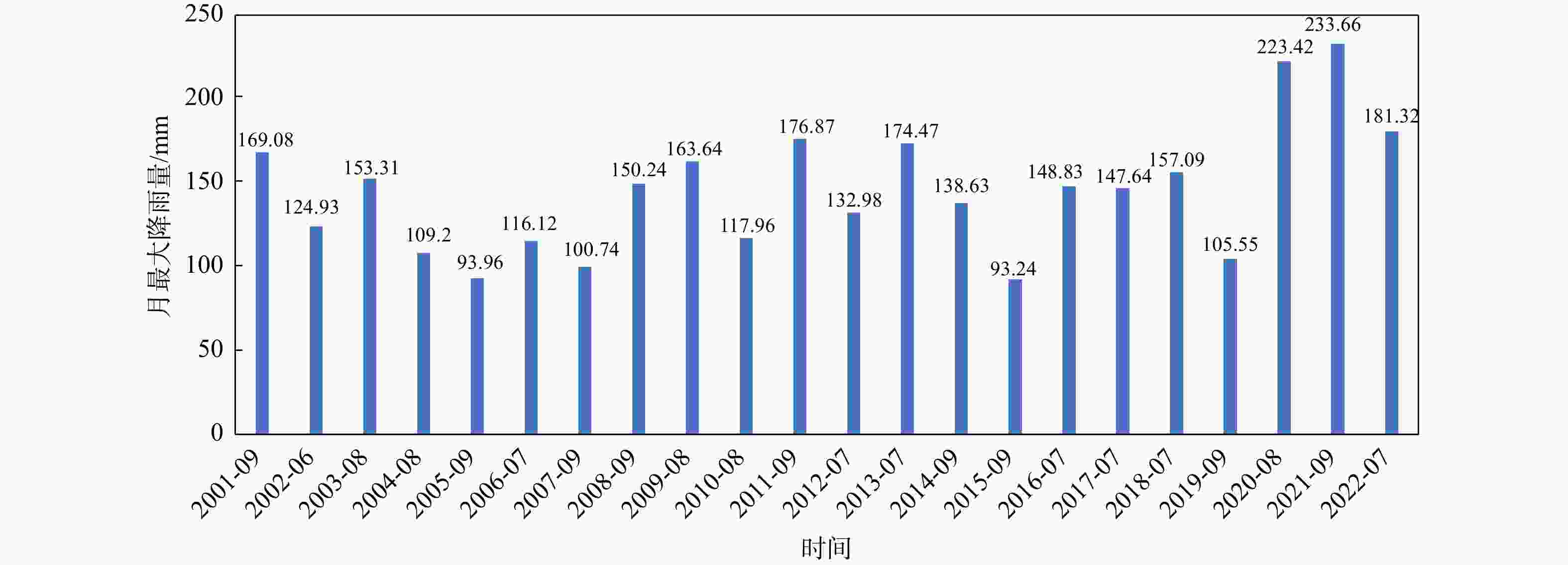
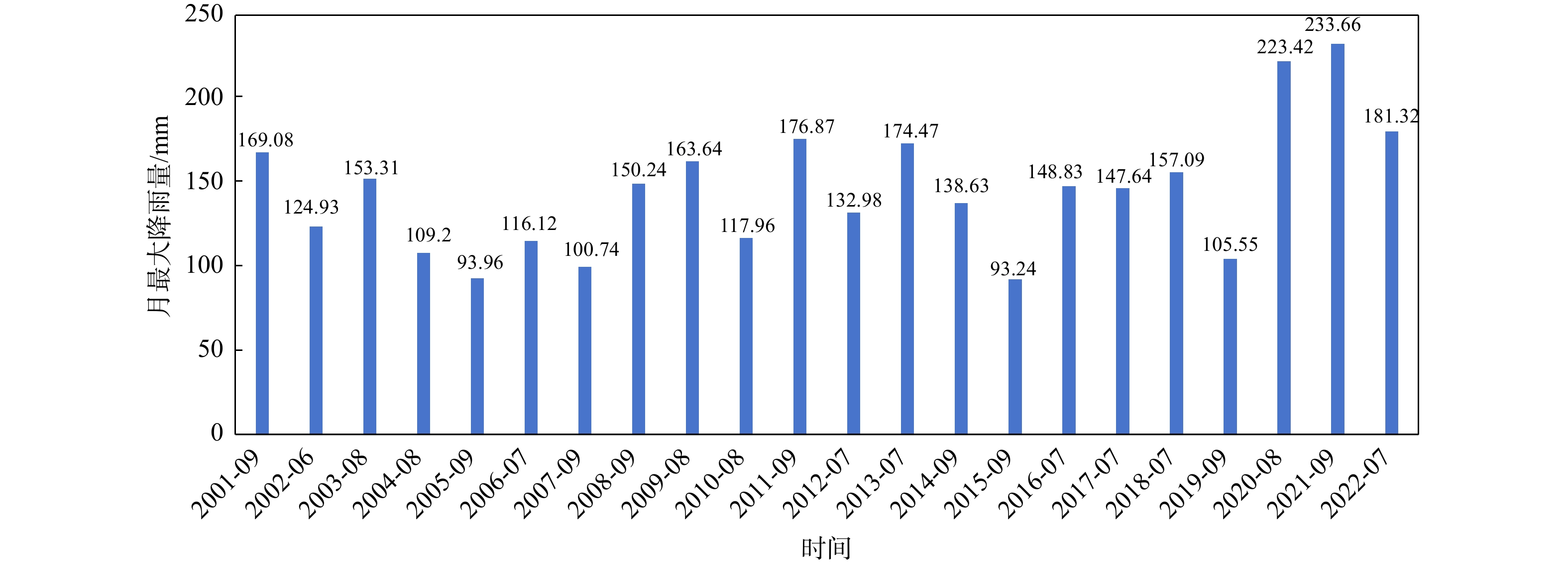
图 12 2001−2022年研究区各年月最大降雨量图
Figure 12. Annual maximum monthly rainfall (2001−2022) in the study area
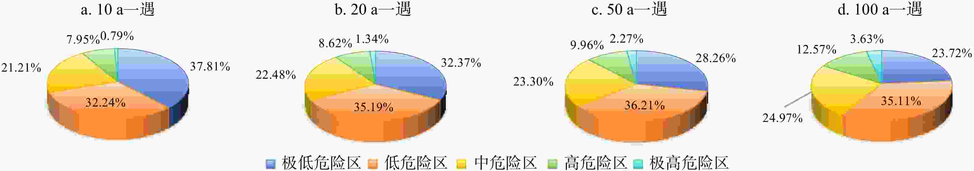
图 14 4种降雨工况危险性分区面积占比图
Figure 14. Area proportion of hazard zoning under four rainfall conditions
表 1 数据来源
Table 1. Data sources
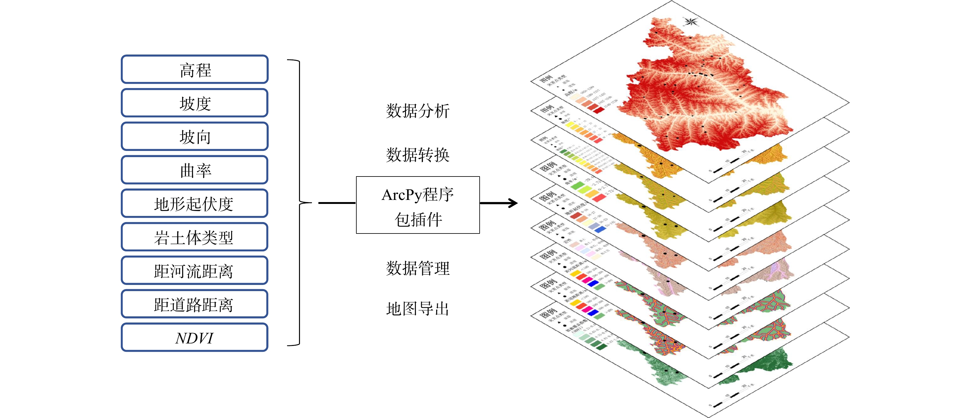
一级因子 二级因子 数据来源 数据精度 地形地貌 高程 基于SAGA7.0软件地形分析模块
和Alos-DEM计算和提取12.5 m 坡度 坡向 曲率 地形起伏度 基础地质 岩土体类型 中国国家地质资料数据中心 500 m 断层褶皱 气象水文 河流 中国1∶400万主要基础数据集 400 m 降雨量 中国气象数据网 30 m 人类活动 道路 中国1∶400万主要基础数据集 400 m 植被覆盖 NDVI 地理空间数据云Landsat-8遥感影像 30 m NDVI. 归一化植被指数,下同  下载: 导出CSV
表 2 评价因子分级及信息量值
Table 2. Classification and IV values of evaluation factors
因子 分级 灾害点个数/个 分级栅格数量/个 分级栅格面积/m2 信息量值 高程/m [ 1058 ,1289 )16 608485 380302991 1.284253630 [ 1289 ,1377 )7 1317352 823345276 − 0.314832308 [ 1377 ,1457 )8 1630754 1019220989 − 0.394719147 [ 1457 ,1540 )12 1552184 970115147 0.060125067 [ 1540 ,1726 ]1 935256 584534972 − 1.918183422 坡度/(°) [0,9) 7 953159 595724375 0.008765236 [9,15) 4 1242953 776845625 − 0.816314099 [15,21) 10 1303633 814770625 0.052311650 [21,27) 8 1086974 679358750 0.010925392 [27,33) 7 767382 479613750 0.225562246 [33,40) 7 474786 296741250 0.705682791 [40,68] 1 215144 134465000 − 0.448670753 坡向/(°) N[0,22.5),[337.5,360] 6 665049 415655625 0.214535566 EN[22.5,67.5) 1 748633 467895625 − 1.695612058 E[67.5,112.5) 3 944041 590025625 − 0.828920490 ES[112.5,157.5) 8 667542 417213750 0.498476051 S[157.5,202.5) 9 664204 415127500 0.621272065 WS[202.5,247.5) 6 673845 421153125 0.201396174 W[247.5,292.5) 7 954627 596641875 0.007226279 WN[292.5,337.5) 4 723506 452191250 − 0.275177659 平面(−1) 0 2584 1615000 0 曲率 [−29.44,−2.72) 7 755668 472292335 0.240945191 [−2.72,0) 19 2350223 1468889970 0.104809896 [0,2.72) 14 2187230 1367018525 − 0.128696869 [2.72,28.32] 4 750910 469318545 − 0.312354189 岩土体类型 黄土 14 4131521 2582200634 − 0.764706755 红黏土 0 205738 128586332 0 砂砾类土 0 1074 670650 0 软硬相间碎屑岩组 29 1644572 1027857804 0.884696905 次软−半坚硬碎屑岩组 1 61126 38203954 0.809694166 距河流距离/m [0,100) 25 1192609 745380334 1.057614410 [100,200) 5 1010958 631848502 − 0.386578551 [200,300) 4 875906 547441357 − 0.466327796 [300,400] 0 751641 469775319 0 >400 10 2212917 1383073863 − 0.476845456 距道路距离/m [0,100) 16 663742 414839058 1.197331278 [100,200) 8 641810 401131058 0.537786529 [200,300) 5 626302 391438738 0.092242079 [300,400] 3 609756 381097518 − 0.391809817 >400 12 3502421 2189013003 − 0.753666199 NDVI [0.21,0.65) 5 126663 79164373 1.690544739 [0.65,0.75) 10 790323 493951624 0.552780697 [0.75,0.81) 8 1503227 939516840 − 0.313291013 [0.81,0.87) 17 2009315 1255822463 0.150300547 [0.87,1.00] 4 1614503 1009064074 − 1.077850971
下载: 导出CSV
表 3 IVM模型和IVM-RF耦合模型的崩滑易发性分区统计
Table 3. Statistics of landslide susceptibility zoning for IVM model and IVM-RF coupled model
评价模型 易发性分区 灾害点个数/个 灾害点占比/% 面积/km2 面积占比/% 灾害点密度/(个·km−2) IVM模型 极低易发区 6 13.64 1004.2651 26.56 0.0060 低易发区 2 4.55 1075.2974 28.44 0.0019 中易发区 25 56.82 1552.7663 41.07 0.0161 高易发区 5 11.36 130.1442 3.44 0.0384 极高易发区 6 13.64 18.5271 0.49 0.3239 IVM-RF耦合模型 极低易发区 1 2.27 1830.3821 48.41 0.0005 低易发区 5 11.36 1237.8994 32.74 0.0040 中易发区 10 22.73 403.1599 10.66 0.0248 高易发区 12 27.27 261.2671 6.91 0.0459 极高易发区 16 36.36 48.2915 1.28 0.3313
下载: 导出CSV
表 4 延安市志丹县不同降雨工况(概率)的月最大降雨量
Table 4. Monthly maximum rainfall at different probabilities in Zhidan County, Yan'an City
降雨工况概率 离均系数ϕ值 月最大降雨量R=$ \bar{{r}} $(1+ϕCv)/mm 10 a一遇 10% 1.33 196.8225485 20 a一遇 5% 1.82 215.5319084 50 a一遇 2% 2.40 237.6776815 100 a一遇 1% 2.81 253.3324520
下载: 导出CSV
表 5 危险性等级分级
Table 5. Hazard level classification
危险性等级 极高危险区 高危险区 中危险区 低危险区 极低危险区 危险性指数$ {H}_{{\mathrm{i}}} $ >0.7 (0.55,0.7] (0.45,0.55] [0.33,0.45] <0.33
下载: 导出CSV
表 6 不同降雨工况下危险性分区面积统计
Table 6. Hazard zoning statistics under different rainfall conditions
面积/km2 降雨工况 极低危险区 低危险区 中危险区 高危险区 极高危险区 10 a一遇 1429.47 1219.17 801.90 300.67 29.80 20 a一遇 1223.97 1330.22 850.05 326.10 50.65 50 a一遇 1068.58 1369.08 881.11 376.57 85.66 100 a一遇 896.72 1327.48 944.21 475.43 137.50
下载: 导出CSV
-
[1] 谢婉丽,王延寿,马中豪,等. 黄土湿陷机理研究现状及发展趋势[J]. 现代地质,2015,29(2):397-407. doi: 10.3969/j.issn.1000-8527.2015.02.025XIE W L,WANG Y S,MA Z H,et al. Research status and prospect of loess collapsibility mechanism[J]. Geoscience,2015,29(2):397-407. (in Chinese with English abstract doi: 10.3969/j.issn.1000-8527.2015.02.025 [2] 滕宏泉,谢婉丽,盖海龙,等. 分形分维理论在地质灾害发育及空间分布规律中的应用:以长安区滑坡、崩塌地质灾害为例[J]. 地质灾害与环境保护,2016,27(1):44-50. doi: 10.3969/j.issn.1006-4362.2016.01.009TENG H Q,XIE W L,GAI H L,et al. Application of fractal dimension theory in geological hazard development and spatial distribution law:Taking Chang'an district landslide and collapse as an example[J]. Journal of Geological Hazards and Environment Preservation,2016,27(1):44-50. (in Chinese with English abstract doi: 10.3969/j.issn.1006-4362.2016.01.009 [3] 谢婉丽,滕宏泉,杜蕾,等. 大西安地区滑坡分类及其特征分析[J]. 地球环境学报,2018,9(1):79-88. doi: 10.7515/JEE182006XIE W L,TENG H Q,DU L,et al. An analysis of landslide classifi cations and characteristics in Xi’an[J]. Journal of Earth Environment,2018,9(1):79-88. (in Chinese with English abstract doi: 10.7515/JEE182006 [4] 赵欢,田伟平,齐洪亮,等. 陕西公路边坡灾害危险性分区研究[J]. 灾害学,2016,31(4):75-81. doi: 10.3969/j.issn.1000-811X.2016.04.014ZHAO H,TIAN W P,QI H L,et al. Research on the risk regionalization of highway slope disasters in Shaanxi Province[J]. Journal of Catastrophology,2016,31(4):75-81. (in Chinese with English abstract doi: 10.3969/j.issn.1000-811X.2016.04.014 [5] ZHENG H,DING M T. Spatiotemporal changes of landslide susceptibility in response to rainfall and its future prediction:A case study of Sichuan Province,China[J]. Ecological Informatics,2024,84:102862. doi: 10.1016/j.ecoinf.2024.102862 [6] YUAN X Y,LIU C,NIE R H,et al. A comparative analysis of certainty factor-based machine learning methods for collapse and landslide susceptibility mapping in Wenchuan County,China[J]. Remote Sensing,2022,14(14):3259. doi: 10.3390/rs14143259 [7] BARREDO J,BENAVIDES A,HERVÁS J,et al. Comparing heuristic landslide hazard assessment techniques using GIS in the Tirajana Basin,Gran Canaria Island,Spain[J]. International Journal of Applied Earth Observation and Geoinformation,2000,2(1):9-23. doi: 10.1016/S0303-2434(00)85022-9 [8] 刘帅,朱杰勇,杨得虎,等. 不同降雨工况条件下的崩滑地质灾害危险性评价[J]. 地质科技通报,2024,43(2):253-267.LIU S,ZHU J Y,YANG D H,et al. Geological hazard risk assessment of collapse and landslide under different rainfall conditions[J]. Bulletin of Geological Science and Technology,2024,43(2):253-267. (in Chinese with English abstract [9] ALAMREW B T,KASSAWMAR T,MENGSTIE L,et al. Combined GIS,FR and AHP approaches to landslide susceptibility and risk zonation in the Baso Liben district,northwestern Ethiopia[J]. Quaternary Science Advances,2024,16:100250. doi: 10.1016/j.qsa.2024.100250 [10] BISWAKARMA P,JOSHI V,ABDO H G,et al. An integrated quantitative and qualitative approach for landslide susceptibility mapping in West Sikkim district,Indian Himalaya[J]. Geomatics,Natural Hazards and Risk,2023,14(1). [11] SONG R X,WANG S Z,SONG L F,et al. Landslide susceptibility assessment based on slope unit and information value method in Changbai Mountain district[J]. Journal of Civil and Transportation Engineering,2024,1(2):39-44. doi: 10.62517/jcte.202406207 [12] BHANDARI B P,DHAKAL S,TSOU C Y. Assessing the prediction accuracy of frequency ratio,weight of evidence,Shannon entropy,and information value methods for landslide susceptibility in the siwalik hills of Nepal[J]. Sustainability,2024,16(5):2092. doi: 10.3390/su16052092 [13] 邢秋菊,赵纯勇,高克昌,等. 基于GIS的滑坡危险性逻辑回归评价研究[J]. 地理与地理信息科学,2004,20(3):49-51. doi: 10.3969/j.issn.1672-0504.2004.03.011XING Q J,ZHAO C Y,GAO K C,et al. Logical regression analysis on the hazard of landslide based on GIS[J]. Geography and Geo-Information Science,2004,20(3):49-51. (in Chinese with English abstract doi: 10.3969/j.issn.1672-0504.2004.03.011 [14] 许冲,戴福初,姚鑫,等. 基于GIS与确定性系数分析方法的汶川地震滑坡易发性评价[J]. 工程地质学报,2010,18(1):15-26. doi: 10.3969/j.issn.1004-9665.2010.01.003XU C,DAI F C,YAO X,et al. GIS platform and certainty factor analysis method based Wenchuan earthquake-induced landslide susceptibility evaluation[J]. Journal of Engineering Geology,2010,18(1):15-26. (in Chinese with English abstract doi: 10.3969/j.issn.1004-9665.2010.01.003 [15] 李郎平,兰恒星,郭长宝,等. 基于改进频率比法的川藏铁路沿线及邻区地质灾害易发性分区评价[J]. 现代地质,2017,31(5):911-929. doi: 10.3969/j.issn.1000-8527.2017.05.004LI L P,LAN H X,GUO C B,et al. Geohazard susceptibility assessment along the Sichuan-Tibet railway and its adjacent area using an improved frequency ratio method[J]. Geoscience,2017,31(5):911-929. (in Chinese with English abstract doi: 10.3969/j.issn.1000-8527.2017.05.004 [16] KLAI A,KATLANE R,HADDAD R,et al. Landslide susceptibility mapping by frequency ratio and fuzzy logic approach:A case study of Mogods and Hedil (Northern Tunisia)[J]. Applied Geomatics,2024,16(1):91-109. doi: 10.1007/s12518-023-00544-5 [17] BANDA K,PIETERSEN K,HAMUTOKO J,et al. Using a comparative of DRASTIC and Bayesian weights of evidence approach to assess transboundary aquifer vulnerability in a data scarcity region:Tuli-Karoo aquifer[J]. Journal of Hydrology:Regional Studies,2024,55:101930. [18] 李嘉昊,谢婉丽,严明,等. 基于PCA与改进AHP-CRITIC法的地质灾害风险评价研究:以神木市为例[J]. 地球环境学报,2023,14(4):472-487. doi: 10.7515/JEE222051LI J H,XIE W L,YAN M,et al. Research on geological hazard risk assessment based on PCA and improved AHP-CRITIC method:A case study of Shenmu,Shaanxi Province[J]. Journal of Earth Environment,2023,14(4):472-487. (in Chinese with English abstract doi: 10.7515/JEE222051 [19] CHANG L L,ZHANG R,WANG C S. Evaluation and prediction of landslide susceptibility in Yichang section of Yangtze River Basin based on integrated deep learning algorithm[J]. Remote Sensing,2022,14(11):2717. doi: 10.3390/rs14112717 [20] 樊芷吟,苟晓峰,秦明月,等. 基于信息量模型与Logistic回归模型耦合的地质灾害易发性评价[J]. 工程地质学报,2018,26(2):340-347.FAN Z Y,GOU X F,QIN M Y,et al. Information and logistic regression models based coupling analysis for susceptibility of geological hazards[J]. Journal of Engineering Geology,2018,26(2):340-347. (in Chinese with English abstract [21] 罗路广,裴向军,黄润秋,等. GIS支持下CF与Logistic回归模型耦合的九寨沟景区滑坡易发性评价[J]. 工程地质学报,2021,29(2):526-535.LUO L G,PEI X J,HUANG R Q,et al. Landslide susceptibility assessment in Jiuzhaigou scenic area with GIS based on certainty factor and logistic regression model[J]. Journal of Engineering Geology,2021,29(2):526-535. (in Chinese with English abstract [22] ZENG B,CHEN X X. Assessment of shallow landslide susceptibility using an artificial neural network[J]. Arabian Journal of Geosciences,2021,14(6):499. doi: 10.1007/s12517-021-06843-8 [23] LUCCHESE L V,DE OLIVEIRA G G,PEDROLLO O C. Investigation of the influence of nonoccurrence sampling on landslide susceptibility assessment using artificial neural networks[J]. Catena,2021,198:105067. doi: 10.1016/j.catena.2020.105067 [24] HAN X M,ZHAO X,WU Y C,et al. A least squares-support vector machine for learning solution to multi-physical transient-state field coupled problems[J]. Engineering Applications of Artificial Intelligence,2024,138:109321. [25] ZUO L L,LIU G H,FANG Z,et al. Assessing the destabilization risk of ecosystems dominated by carbon sequestration based on interpretable machine learning method[J]. Ecological Indicators,2024,167:112593. doi: 10.1016/j.ecolind.2024.112593 [26] MELATI D N,UMBARA R P,ASTISIASARI A,et al. A comparative evaluation of landslide susceptibility mapping using machine learning-based methods in Bogor area of Indonesia[J]. Environmental Earth Sciences,2024,83(3):86. doi: 10.1007/s12665-023-11402-3 [27] 刘艺梁,殷坤龙,刘斌. 逻辑回归和人工神经网络模型在滑坡灾害空间预测中的应用[J]. 水文地质工程地质,2010,37(5):92-96. doi: 10.3969/j.issn.1000-3665.2010.05.017LIU Y L,YIN K L,LIU B. Application of logistic regression and artificial neural networks in spatial assessment of landslide hazards[J]. Hydrogeology & Engineering Geology,2010,37(5):92-96. (in Chinese with English abstract doi: 10.3969/j.issn.1000-3665.2010.05.017 [28] WANG W,WU G F,SONG X Y. The application of neural networks to comprehensive prediction by seismology prediction method[J]. Acta Seismologica Sinica,2000,13(2):210-215. doi: 10.1007/s11589-000-0012-0 [29] 田乃满,兰恒星,伍宇明,等. 人工神经网络和决策树模型在滑坡易发性分析中的性能对比[J]. 地球信息科学学报,2020,22(12):2304-2316. doi: 10.12082/dqxxkx.2020.190766TIAN N M,LAN H X,WU Y M,et al. Performance comparison of BP artificial neural network and CART decision tree model in landslide susceptibility prediction[J]. Journal of Geo-Information Science,2020,22(12):2304-2316. (in Chinese with English abstract doi: 10.12082/dqxxkx.2020.190766 [30] SHAHIN A M ,JAKSA B M ,MAIER R H . Artificial neural network applications in geotechnical engineering[J]. Australian Geomechanics,2001,36(1):49-62. [31] 黄发明,殷坤龙,蒋水华,等. 基于聚类分析和支持向量机的滑坡易发性评价[J]. 岩石力学与工程学报,2018,37(1):156-167.HUANG F M,YIN K L,JIANG S H,et al. Landslide susceptibility assessment based on clustering analysis and support vector machine[J]. Chinese Journal of Rock Mechanics and Engineering,2018,37(1):156-167. (in Chinese with English abstract [32] RIAZ M T,RIAZ M T,REHMAN A,et al. An integrated approach of support vector machine (SVM) and weight of evidence (WOE) techniques to map groundwater potential and assess water quality[J]. Scientific Reports,2024,14:26186. doi: 10.1038/s41598-024-76607-3 [33] GAO X C,BAI W T,DANG Q L,et al. Learnable self-supervised support vector machine based individual selection strategy for multimodal multi-objective optimization[J]. Information Sciences,2025,690:121553. doi: 10.1016/j.ins.2024.121553 [34] 马志江,陈汉林,杨树锋. 基于支持向量机理论的滑坡灾害预测:以浙江庆元地区为例[J]. 浙江大学学报(理学版),2003,30(5):592-596. doi: 10.3321/j.issn:1008-9497.2003.05.027MA Z J,CHEN H L,YANG S F. Prediction of landslide hazard based on support vector machine theory:A case study of Qingyuan area in Zhejiang Province[J]. Journal of Zhejiang University (Sciences Edition),2003,30(5):592-596. (in Chinese with English abstract doi: 10.3321/j.issn:1008-9497.2003.05.027 [35] ZHU Y T,GU C S,DIACONEASA M A. A missing data processing method for dam deformation monitoring data using spatiotemporal clustering and support vector machine model[J]. Water Science and Engineering,2024,17(4):417-424. doi: 10.1016/j.wse.2024.08.003 [36] 郭衍昊,窦杰,向子林,等. 基于优化负样本采样策略的梯度提升决策树与随机森林的汶川同震滑坡易发性评价[J]. 地质科技通报,2024,43(3):251-265.GUO Y H,DOU J,XIANG Z L,et al. Susceptibility evaluation of Wenchuan coseismic landslides by gradient boosting decision tree and random forest based on optimal negative sample sampling strategies[J]. Bulletin of Geological Science and Technology,2024,43(3):251-265. (in Chinese with English abstract [37] BREIMAN L. Random forests[J]. Machine Learning,2001,45(1):5-32. doi: 10.1023/A:1010933404324 [38] 李苍柏,肖克炎,李楠,等. 支持向量机、随机森林和人工神经网络机器学习算法在地球化学异常信息提取中的对比研究[J]. 地球学报,2020,41(2):309-319. doi: 10.3975/cagsb.2020.022501LI C B,XIAO K Y,LI N,et al. A comparative study of support vector machine,random forest and artificial neural network machine learning algorithms in geochemical anomaly information extraction[J]. Acta Geoscientica Sinica,2020,41(2):309-319. (in Chinese with English abstract doi: 10.3975/cagsb.2020.022501 [39] 刘磊. 三峡水库万州区库岸滑坡灾害风险评价研究[D]. 武汉:中国地质大学(武汉),2016.LIU L. Assessment of landslide risk along Wanzhou area in Three Gorges reservoir[D]. Wuhan:China University of Geosciences (Wuhan),2016. (in Chinese with English abstract [40] 严明,谢婉丽,何亚南,等. 基于极值降雨假设法的城镇地质灾害风险性评价耦合模型研究:以安康市岚皋县官元镇为例[J]. 灾害学,2023,38(4):219-227. doi: 10.3969/j.issn.1000-811X.2023.04.034YAN M,XIE W L,HE Y N,et al. Research on the coupling model of urban geological hazard risk assessment based on the assumption of extreme rainfall:A case study of Guanyuan Town,Langao County,Ankang City[J]. Journal of Catastrophology,2023,38(4):219-227. (in Chinese with English abstract doi: 10.3969/j.issn.1000-811X.2023.04.034 [41] 汤国安. 地理信息系统教程[M]. 2版. 北京:高等教育出版社,2019.TANG G A. Gis Tutorial [M]. Second Edition. Beijing:Higher Education Press,2019. (in Chinese) [42] 国家质量监督检验检疫总局,中国国家标准化管理委员会. 中国地震动参数区划图:GB 18306-2015[S]. 北京:中国标准出版社,2016.General Administration of Quality Supervision, Inspection and Quarantine of the People's Republic of China,Standardization Administration of the People's Republic of China. Seismic ground motion parameters zonation map of China:GB 18306-2015[S]. Beijing:Standards Press of China,2016. (in Chinese) -

 下载:
下载:


 点击查看大图
计量
- 文章访问数: 760
- PDF下载量: 65
- 被引次数: 0

