
 投审稿入口
投审稿入口

A method for optimizing SBAS-InSAR interpretation results based on landslide susceptibility
-
摘要:
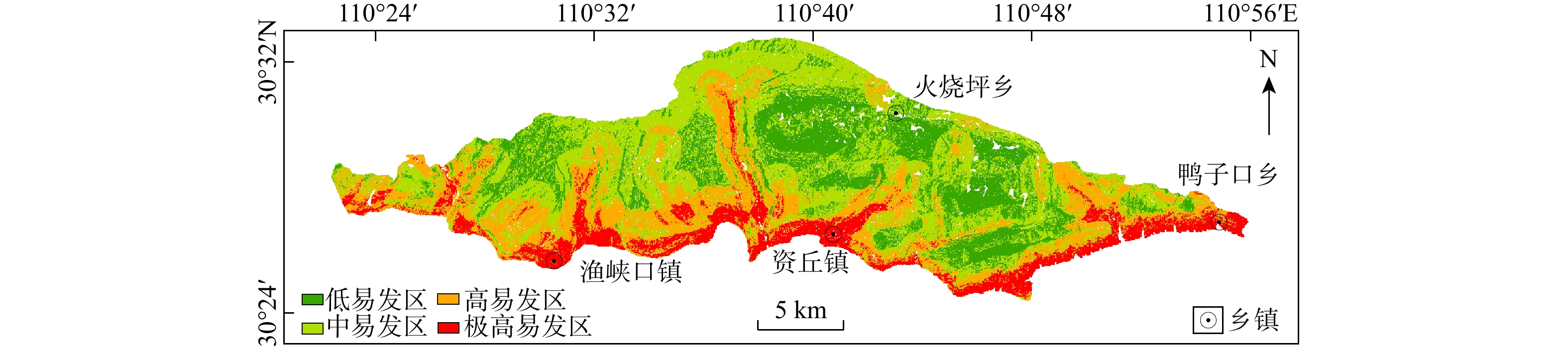
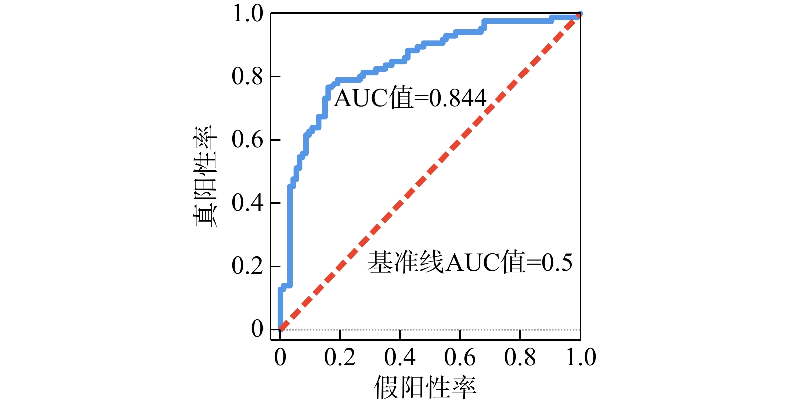
短基线集干涉合成孔径雷达(SBAS-InSAR)技术解译结果具有多解性,直接利用解译的形变点识别滑坡隐患区具有较大的不确定性。以清江北岸(长阳段)为研究区,提出了一种利用滑坡易发性等综合优化SBAS-InSAR解译结果的方法。首先将SBAS-InSAR解译的形变点进行聚类和异常值分析(Anselin Local Moran's I工具),保留低值聚类形变点;然后,选取高程、坡度、坡向、工程地质岩组、距断层距离、距水系距离、距道路距离、地形湿度指数8个指标,采用信息量法评价并得到滑坡易发性分区图,利用受试者工作特征(ROC)曲线验证得到ROC曲线下面积(AUC)值为0.844,表明易发性评价结果可靠;最后,通过设置阈值(地表形变速率
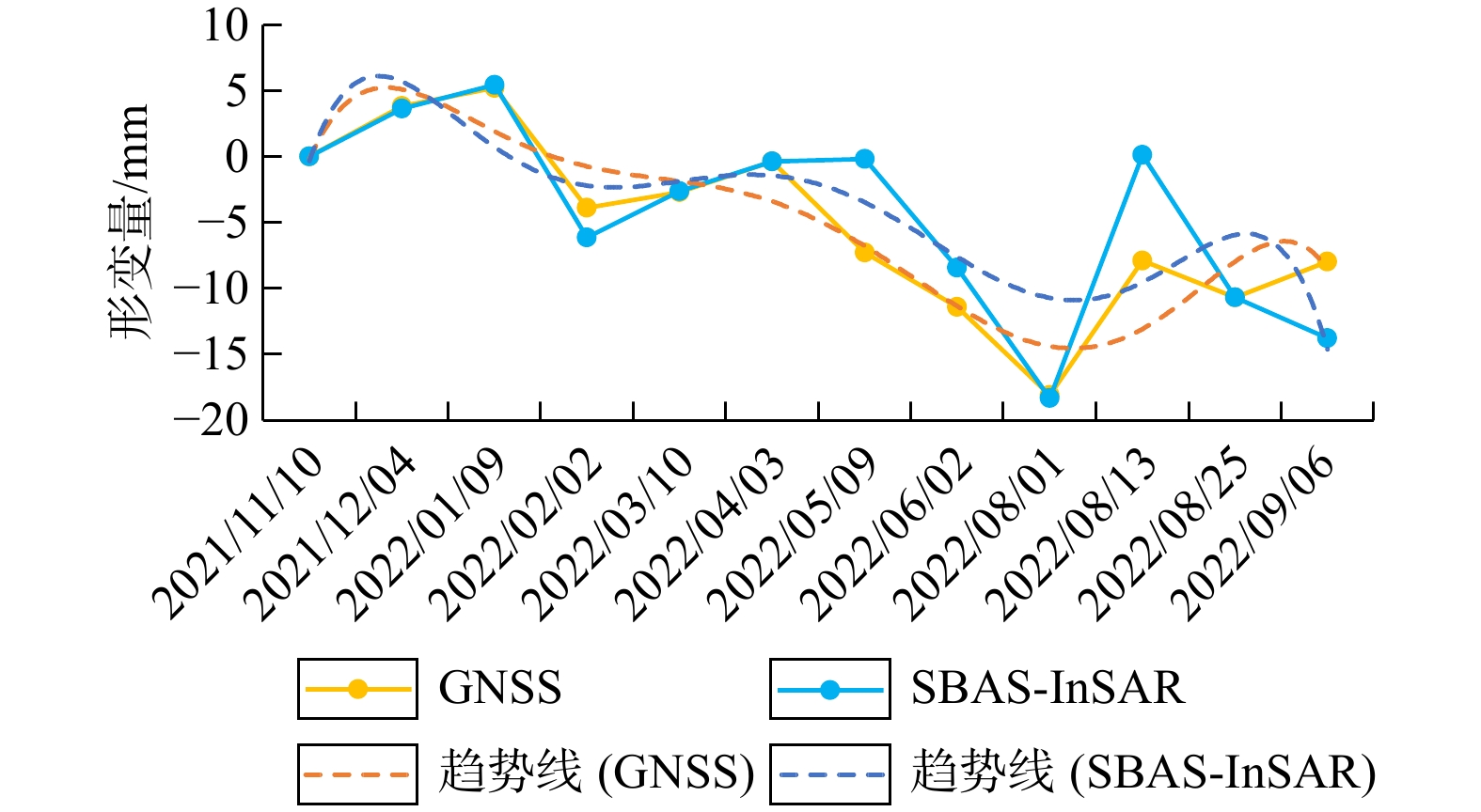
v ≤−10 mm/a)和易发性结果对低值聚类形变点进行筛选,得到优化后的SBAS-InSAR结果图。选取部分区域进行野外验证,结果显示:优化后的形变点数量减少,其分布特征与研究区历史滑坡的发育规律更一致。此外,以渔坪村一组滑坡与偏山滑坡作为典型实例,比较SBAS-InSAR与全球导航卫星系统(GNSS)在同一时刻监测到的地表形变量。其中渔坪村一组滑坡显示的SBAS-InSAR与GNSS在同一时刻监测到的地表形变量差值范围为0~7.87 mm,平均约为2.23 mm,均方根误差(RMSE )为3.67。本研究提出的SBAS-InSAR解译结果的优化方法具有较好的实用性及可靠性,可为合成孔径雷达干涉测量(InSAR)技术应用于地质灾害领域提供有益参考。-
关键词:
- 滑坡 /
- 短基线集干涉合成孔径雷达(SBAS-InSAR) /
- Anselin Local Moran's I工具 /
- 易发性 /
- 优化方法
Abstract:ObjectiveThe interpretation results of small baseline subset interferometric synthetic aperture radar (SBAS-InSAR) exhibit multiple solutions, making it uncertain to directly use the interpreted deformation points for identifying potential landslide-prone areas. Therefore, taking the north bank of the Qingjiang River (Changyang Section) as the study area, this study proposed a method to comprehensively optimize SBAS-InSAR interpretation results by incorporating landslide susceptibility evaluation.
MethodsFirstly, the deformation points interpreted by SBAS-InSAR were analyzed using clustering and outlier detection (Anselin Local Moran's I), and low-value cluster deformation points were retained. Subsequently, eight factors, including elevation, slope, slope aspect, engineering geological rock group, distance to fault, distance to water system, distance to road, topographic wetness index, were selected to evaluate and generate a landslide susceptibility zoning map using the information value method. The reliability of the landslide susceptibility evaluation was confirmed by a receiver operating characteristic (ROC) curve, with an AUC value of 0.844.
ResultsThe optimized SBAS-InSAR results were obtained by filtering low-value cluster deformation points based on a threshold value (deformation rate (
v ) ≤ −10 mm/a) and incorporating the landslide susceptibility zoning map. Field verification in selected areas showed that the number of deformation points was reduced after optimization, and their distribution characteristics were more consistent with the historical landslide development in the study area. Additionally, taking the Yupingcun landslide group and the Pianshan landslide as typical cases, the surface deformation values monitored by SBAS-InSAR and GNSS at the same time were compared. In the case of the Yupingcun landslide, the difference between surface displacement values monitored by SBAS-InSAR and global navigation satellite system (GNSS) ranged from 0 to 7.87 mm, with an average difference of approximately 2.23 mm and anRMSE of 3.67.ConclusionThe proposed optimization method for SBAS-InSAR interpretation was demonstrated to be both practical and reliable, providing useful references for the application of InSAR technology in the field of geological disasters.
-
Key words:
- landslide /
- SBAS-InSAR /
- Anselin Local Moran's I /
- susceptibility /
- optimization method
-

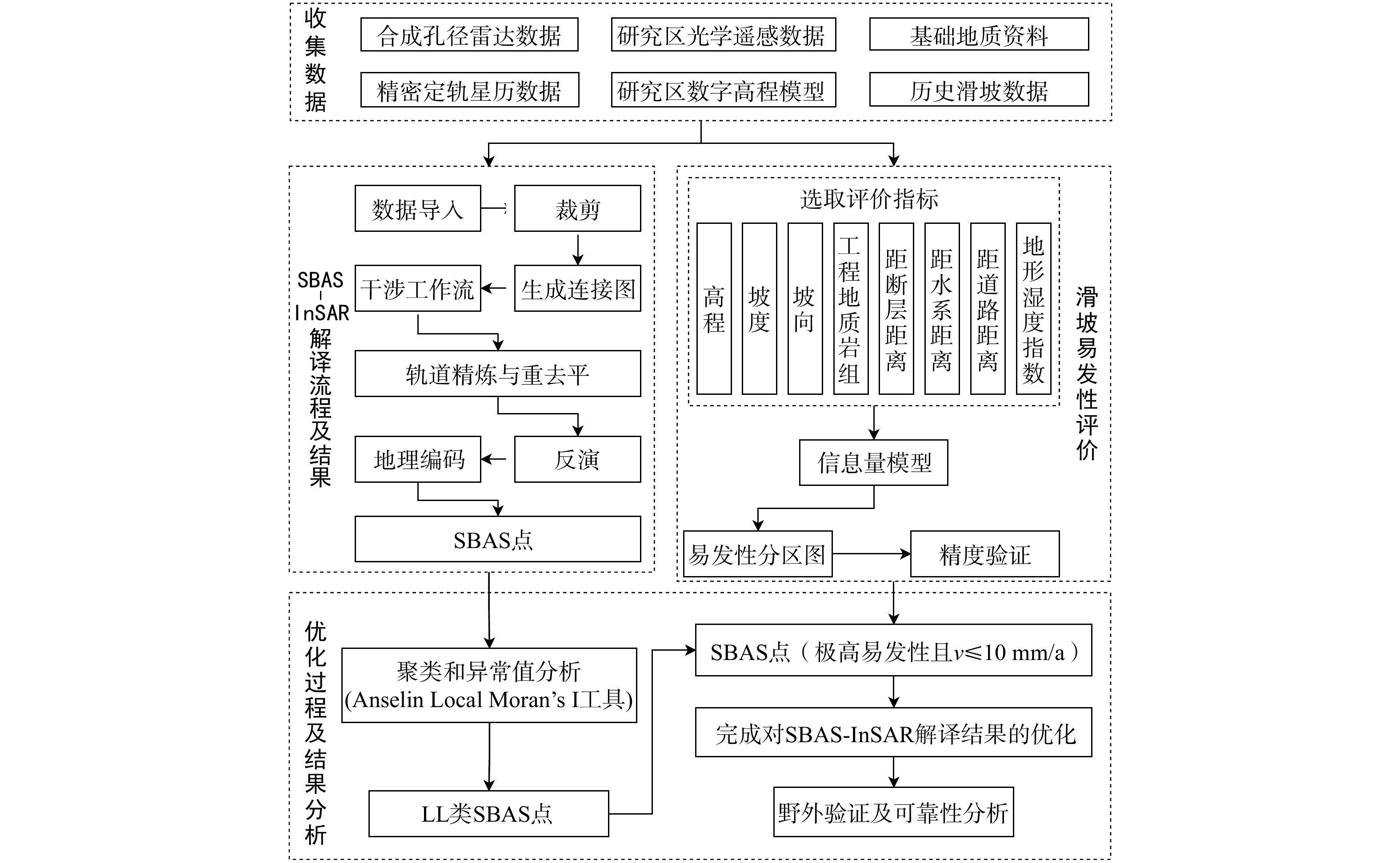
图 2 本研究技术路线图
SBAS-InSAR. 短基线集干涉合成孔径雷达;SBAS点. 通过SBAS-InSAR技术解译出的形变点;LL类. 低值聚类;v. 地表形变速率;下同
Figure 2. Technical flowchart of the study

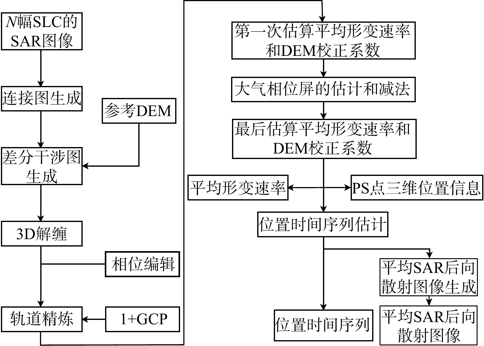
图 3 SBAS-InSAR技术流程图
SLC. 单视复数影像;SAR. 合成孔径雷达;DEM. 数字高程模型;GCP. 地面控制点;PS点. 通过永久散射体合成孔径雷达干涉测量(PS-InSAR)技术解译出的形变点
Figure 3. Technical flowchart of SBAS-InSAR

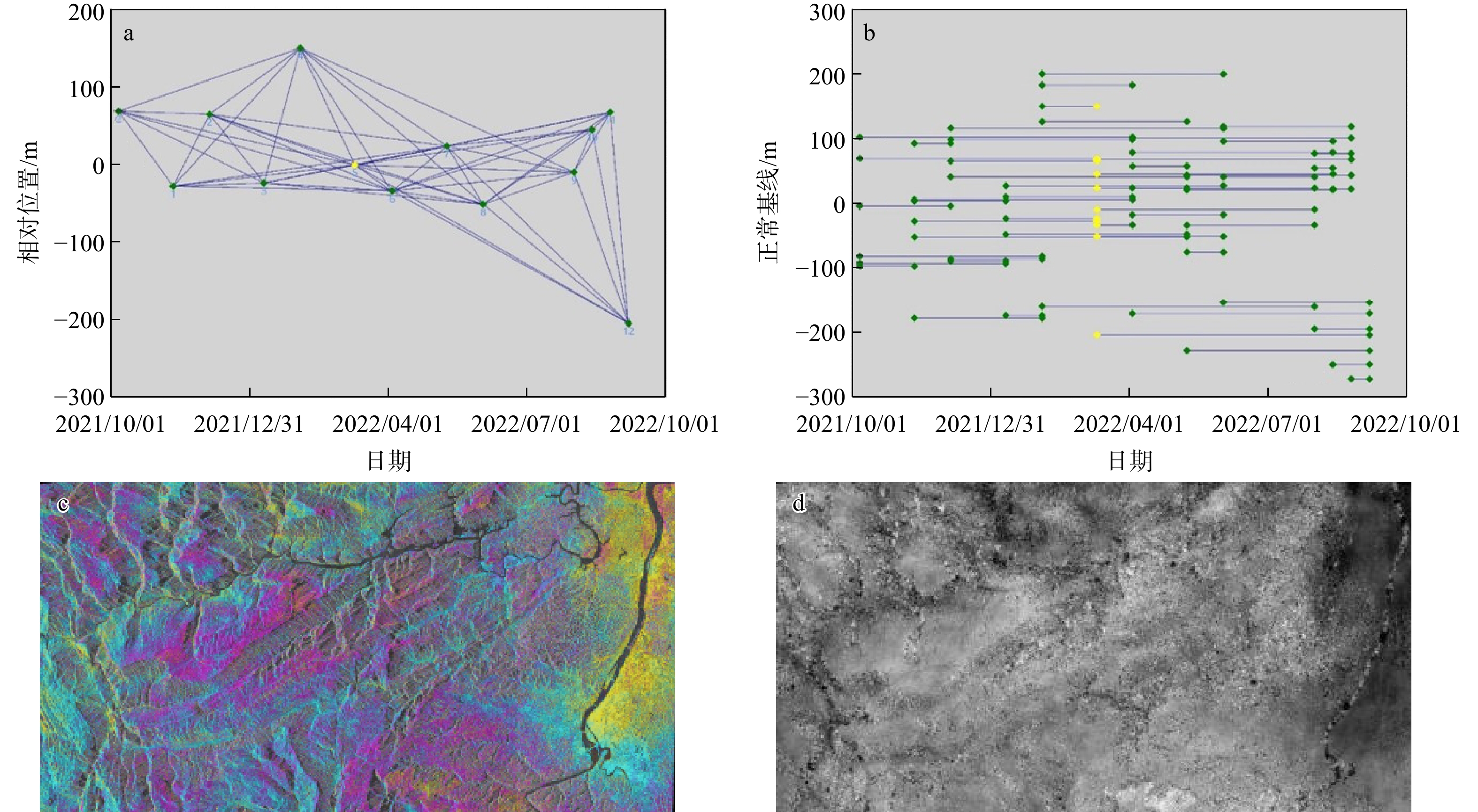
图 4 SBAS-InSAR技术处理过程图
a. 时空基线图;b. 干涉像对图;c. 干涉图;d.解缠图
Figure 4. Technical processing flowchart for SBAS-InSAR

图 5 研究区评价因子选取及重分类
Figure 5. Selection and reclassification of evaluation factors in the study area

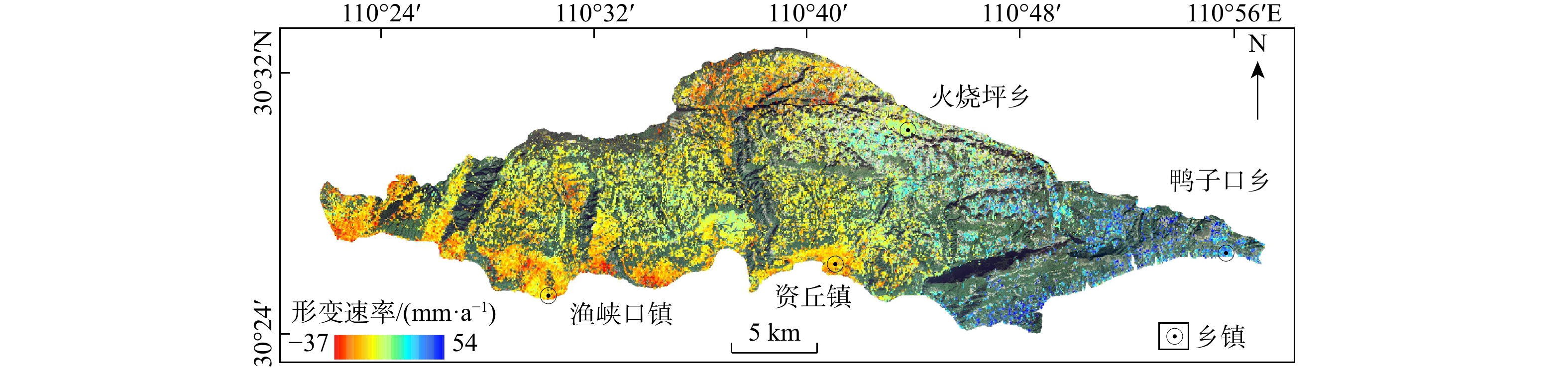
图 6 研究区SBAS-InSAR解译形变速率图
Figure 6. SBAS-InSAR-derived deformation velocity map of the study area

图 8 滑坡易发性评价精度受试者工作特征曲线(ROC)
AUC值. ROC曲线下面积
Figure 8. Receiver operating characteristic curve for landslide susceptibility evaluation

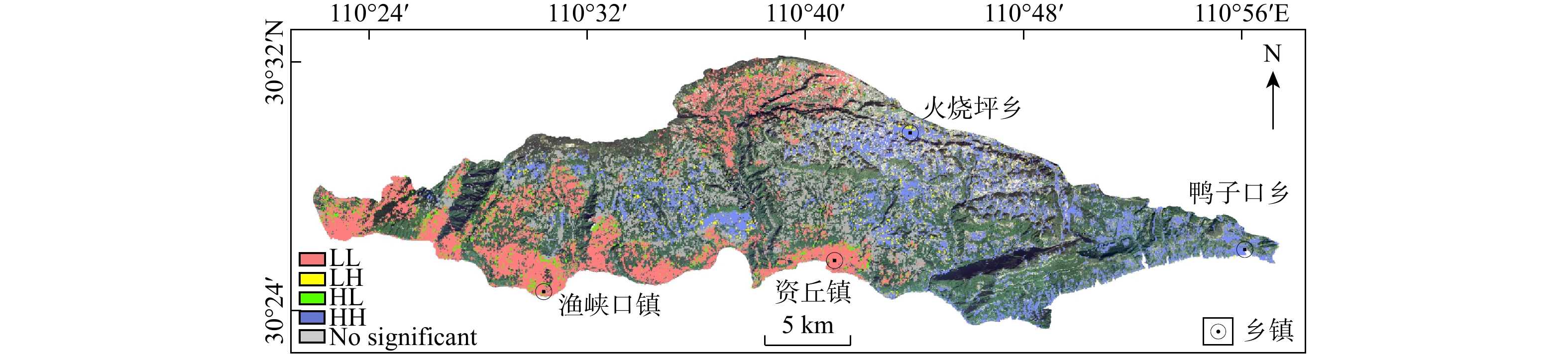
图 9 聚类和异常值分析结果图
LL,LH,HL,HH,No Signifiant为形变点类型代号,分别表示低值聚类、低值被高值包围、高值被低值包围、高值聚类、无参考意义
Figure 9. Results of clustering and outlier analysis

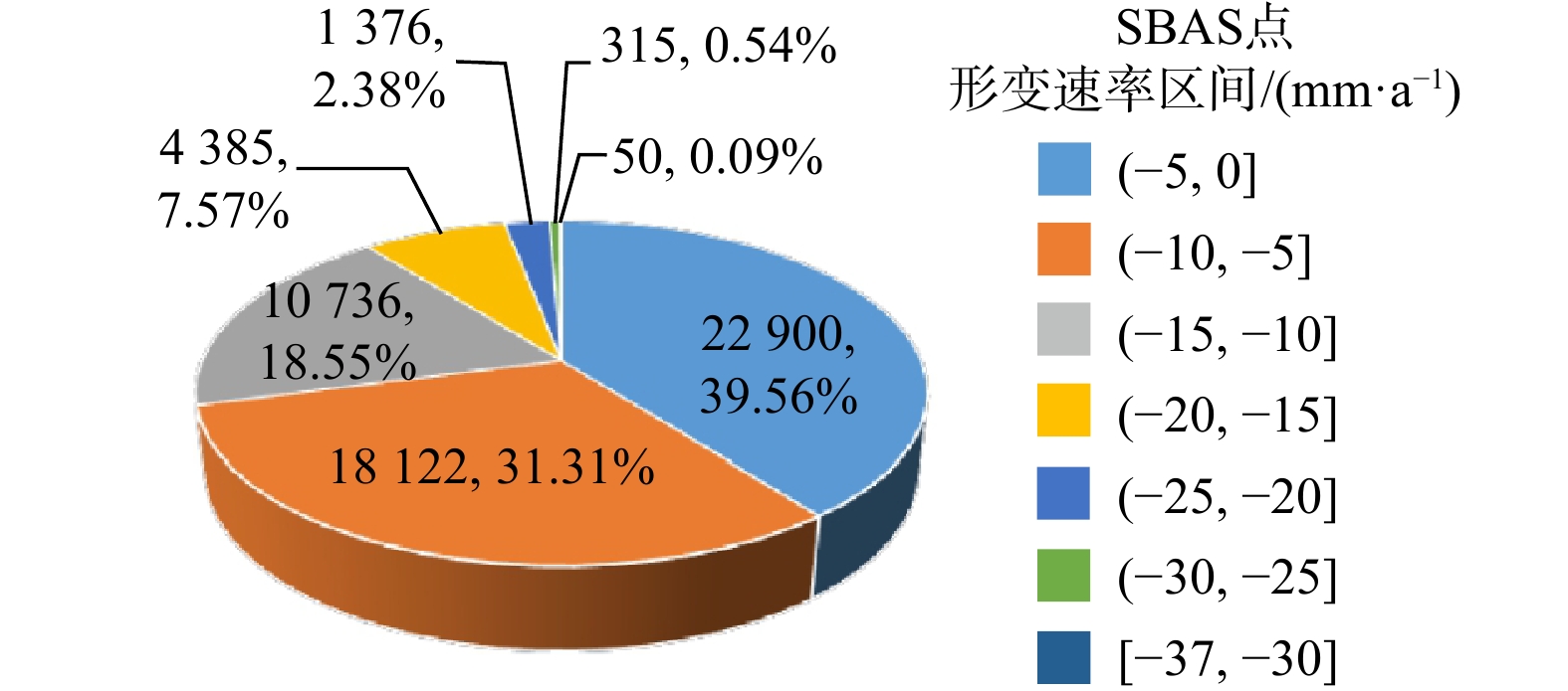
图 10 研究区形变速率区间统计(315,0.54%分别代表形变速率区间形变点数目和形变点数量占总形变点数量的比例)
Figure 10. Statistical distribution of deformation rate interval in the study area

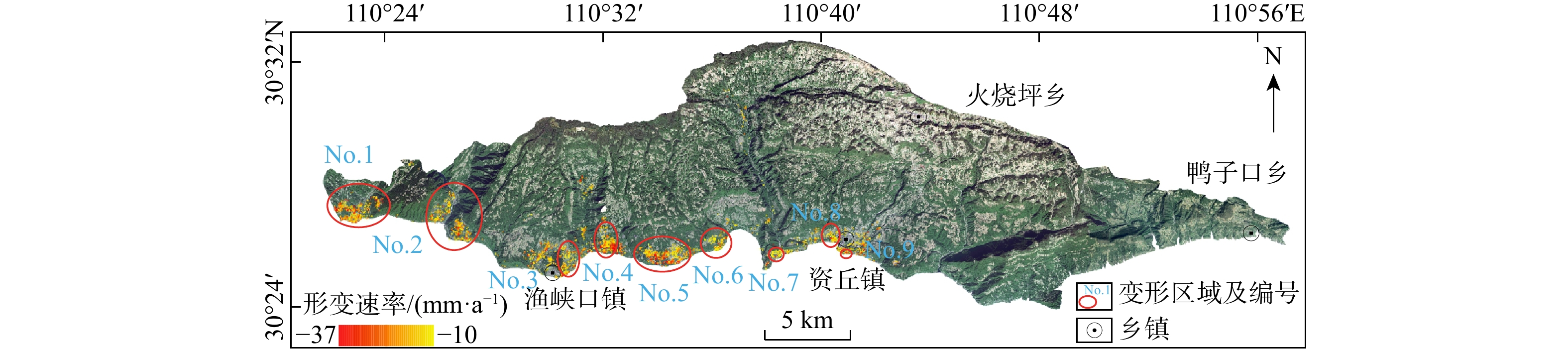
图 11 研究区SBAS-InSAR解译结果优化图
Figure 11. Optimization of SBAS-InSAR interpretation results in the study area

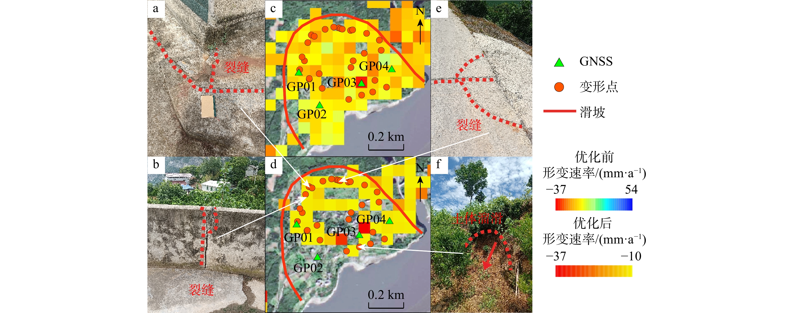
图 12 部分区域优化前后形变速率对比(a~h)及野外调查现象(i~l)(No.1~No.6为变形区域编号,位置见图11)
Figure 12. Comparison of deformation rates before and after optimization (a-h) and field survey phenomena (i-l) in some regions

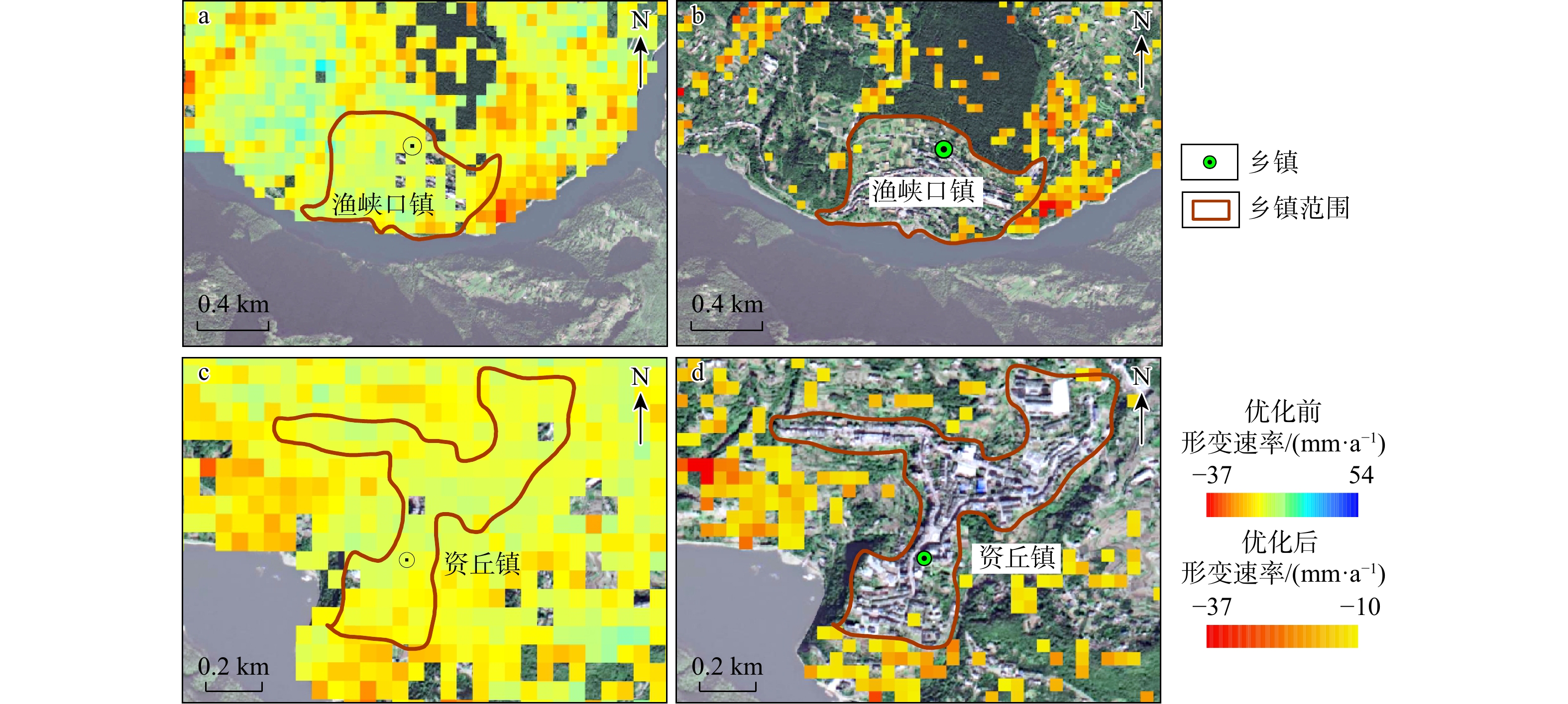
图 13 优化前后集镇形变速率对比
a. 渔峡口镇形变速率(优化前);b. 渔峡口镇形变速率(优化后);c. 资丘镇形变速率(优化前);d. 资丘镇形变速率(优化后)
Figure 13. Comparison of deformation rates in towns before and after optimization

图 14 渔坪村一组滑坡SBAS-InSAR解译点形变量和全球导航卫星系统(GNSS)监测形变量对比
Figure 14. Comparison of deformation between SBAS-InSAR interpreted points and GNSS monitoring of Yupingcun landslide

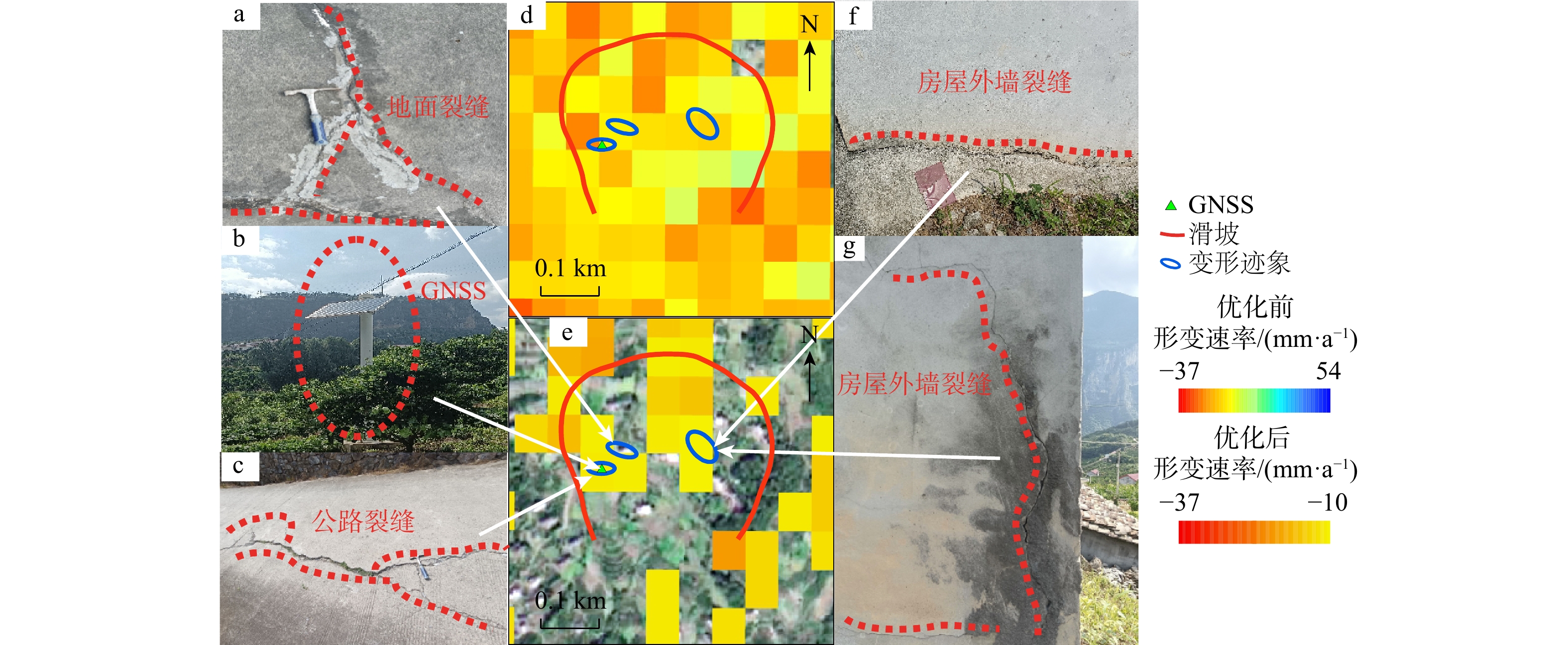
图 15 渔坪村一组滑坡形变分析
a. 已修复的裂缝;b. 全球导航卫星系统(GNSS);c. 公路裂缝;d. 滑坡形变速率(优化前);e. 滑坡形变速率(优化后);f,g. 居民房屋墙体裂缝
Figure 15. Deformation analysis of Yupingcun landslide

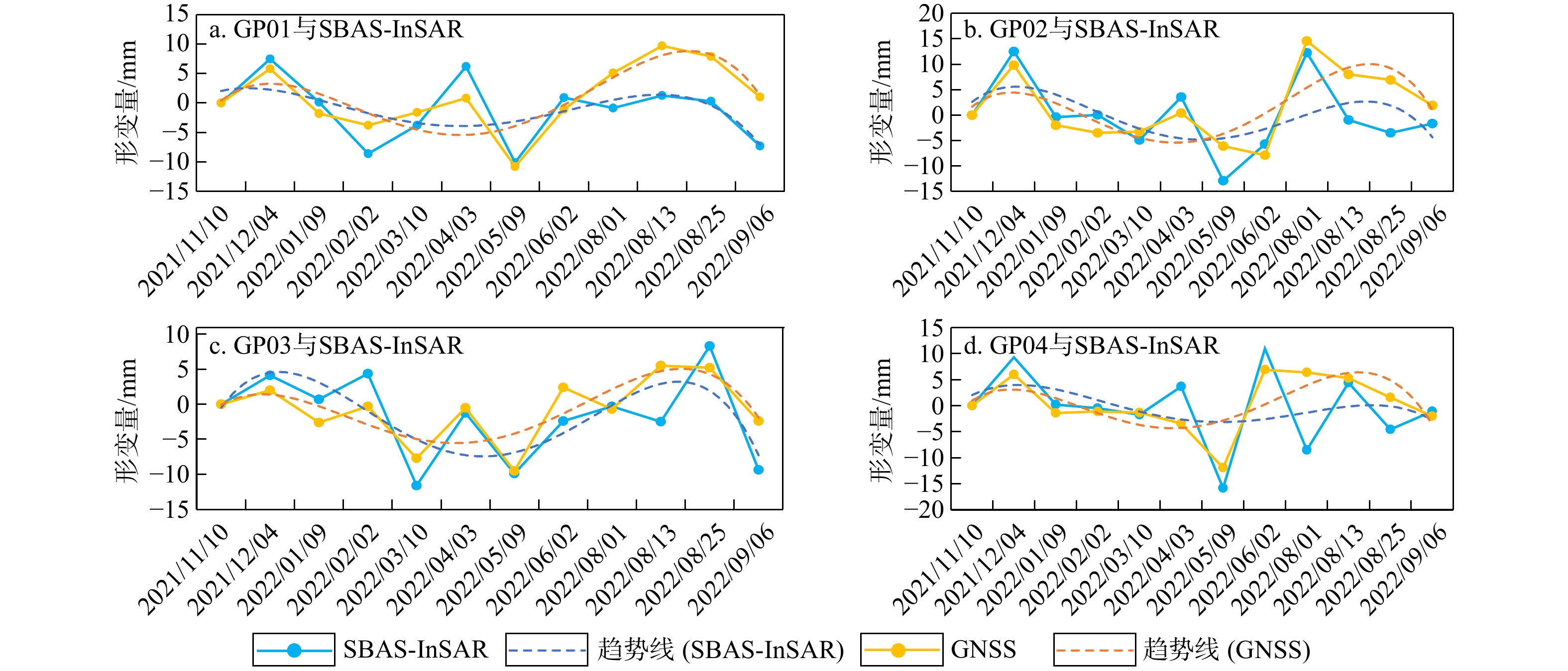
图 16 偏山滑坡SBAS-InSAR解译点形变量和GNSS监测形变量对比
GP01~GP04. 全球导航卫星系统(GNSS)解译点,下同
Figure 16. Comparison of deformation between SBAS-InSAR interpreted points and GNSS monitoring of Pianshan landslide
-
[1] 王立伟. 基于D-InSAR数据分析的高山峡谷区域滑坡位移识别[D]. 北京: 北京科技大学, 2015.WANG L W. Identification of landslide displacement in alpine valley region based on D-InSAR data analysis[D]. Beijing: University of Science and Technology Beijing, 2015. (in Chinese with English abstract [2] ZHANG C L, LI Z H, DING M T, et al. Dynamic deformation monitoring and scenario simulation of the Xiaomojiu landslide in the Jinsha River basin, China[J]. Landslides, 2023, 20(11): 2343-2358. doi: 10.1007/s10346-023-02103-w [3] AHMAD RATHER A, BUKHARI S K. Understanding Joshimath landslide using PS interferometry and PSDS InSAR[J]. Journal of Earth System Science, 2024, 133(2): 93. doi: 10.1007/s12040-024-02312-4 [4] ASLAN G, FOUMELIS M, RAUCOULES D, et al. Landslide mapping and monitoring using persistent scatterer interferometry (PSI) technique in the French Alps[J]. Remote Sensing, 2020, 12(8): 1305. doi: 10.3390/rs12081305 [5] ROY P, MARTHA T R, KHANNA K, et al. Time and path prediction of landslides using InSAR and flow model[J]. Remote Sensing of Environment, 2022, 271: 112899. doi: 10.1016/j.rse.2022.112899 [6] SCHLÖGL M, GUTJAHR K, FUCHS S. The challenge to use multi-temporal InSAR for landslide early warning[J]. Natural Hazards, 2022, 112(3): 2913-2919. doi: 10.1007/s11069-022-05289-9 [7] ZHANG J M, ZHU W, CHENG Y Q, et al. Landslide detection in the Linzhi-Ya'an section along the Sichuan-Tibet Railway based on InSAR and hot spot analysis methods[J]. Remote Sensing, 2021, 13(18): 3566. doi: 10.3390/rs13183566 [8] SOLARI L, DEL SOLDATO M, MONTALTI R, et al. A sentinel-1 based hot-spot analysis: Landslide mapping in north-western Italy[J]. International Journal of Remote Sensing, 2019, 40(20): 7898-7921. doi: 10.1080/01431161.2019.1607612 [9] 徐帅, 王尚晓, 牛瑞卿. 基于InSAR技术的三峡库区巫山−奉节段潜在滑坡识别[J]. 安全与环境工程, 2020, 27(1): 32-38.XU S, WANG S X, NIU R Q. Identification of the potential landslide in Wushan-Fengjie in the Three Gorges Reservoir area based on InSAR technology[J]. Safety and Environmental Engineering, 2020, 27(1): 32-38. (in Chinese with English abstract [10] POKHAREL B, ALVIOLI M, LIM S. Assessment of earthquake-induced landslide inventories and susceptibility maps using slope unit-based logistic regression and geospatial statistics[J]. Scientific Reports, 2021, 11: 21333. doi: 10.1038/s41598-021-00780-y [11] BRALET A, TROUVÉ E, CHANUSSOT J, et al. ISSLIDE: A new insar dataset for slow sliding area detection with machine learning[J]. IEEE Geoscience and Remote Sensing Letters, 2024, 21: 1-5. [12] LI Z H, SHI A C, LI X R, et al. Deep learning-based landslide recognition incorporating deformation characteristics[J]. Remote Sensing, 2024, 16(6): 992. doi: 10.3390/rs16060992 [13] YANG S, WANG Y Z, WANG P Z, et al. Automatic identification of landslides based on deep learning[J]. Applied Sciences, 2022, 12(16): 8153. doi: 10.3390/app12168153 [14] CIGNETTI M, GODONE D, NOTTI D, et al. State of activity classification of deep-seated gravitational slope deformation at regional scale based on Sentinel-1 data[J]. Landslides, 2023, 20(12): 2529-2544. doi: 10.1007/s10346-023-02114-7 [15] GUO H J, YI B J, YAO Q X, et al. Identification of landslides in mountainous area with the combination of SBAS-InSAR and Yolo model[J]. Sensors, 2022, 22(16): 6235. doi: 10.3390/s22166235 [16] 董佳慧, 牛瑞卿, 亓梦茹, 等. InSAR技术和孕灾背景指标相结合的地灾隐患识别[J]. 地质科技通报, 2022, 41(2): 187-196.DONG J H, NIU R Q, QI M R, et al. Identification of geological hazards based on the combination of InSAR technology and disaster background indicators[J]. Bulletin of Geological Science and Technology, 2022, 41(2): 187-196. (in Chinese with English abstract [17] LIU Z J, QIU H J, ZHU Y R, et al. Efficient identification and monitoring of landslides by time-series InSAR combining single- and multi-look phases[J]. Remote Sensing, 2022, 14(4): 1026. doi: 10.3390/rs14041026 [18] 张端淼, 徐勇, 吴昱. 清江隔河岩库区滑坡灾害时空分布特征和主要控制因素分析[J]. 资源环境与工程, 2015, 29(4): 449-453.ZHANG D M, XU Y, WU Y. Analysis of spatial-temporal distribution characteristics and main control factors of landslide in Geheyan reservoir area on Qingjiang[J]. Resources Environment & Engineering, 2015, 29(4): 449-453. (in Chinese with English abstract [19] 朱建军, 李志伟, 胡俊. InSAR变形监测方法与研究进展[J]. 测绘学报, 2017, 46(10): 1717-1733. doi: 10.11947/j.AGCS.2017.20170350ZHU J J, LI Z W, HU J. Research progress and methods of InSAR for deformation monitoring[J]. Acta Geodaetica et Cartographica Sinica, 2017, 46(10): 1717-1733. (in Chinese with English abstract doi: 10.11947/j.AGCS.2017.20170350 [20] 张伟, 陈宏, 纪成亮, 等. 基于升降轨InSAR数据的高山峡谷区滑坡易发性评价[J]. 地质科技通报, 2025, 44(2): 94-103. doi: 10.19509/j.cnki.dzkq.tb20230560ZHANG W, CHEN H, JI C L, et al. Landslide susceptibility assessment in the alpine and canyon areas based on ascending and descending InSAR data[J]. Bulletin of Geological Science and Technology, 2025, 44(2): 94-103. (in Chinese with English abstract doi: 10.19509/j.cnki.dzkq.tb20230560 [21] 杨沛璋, 崔圣华, 裴向军, 等. 基于SBAS-InSAR和光学遥感影像的大型倾倒变形体变形演化[J]. 地质科技通报, 2023, 42(6): 63-75.YANG P Z, CUI S H, PEI X J, et al. Deformation and evolution of large dumping bodies based on SBAS-InSAR and optical remote sensing images[J]. Bulletin of Geological Science and Technology, 2023, 42(6): 63-75. (in Chinese with English abstract [22] BERARDINO P, FORNARO G, LANARI R, et al. A new algorithm for surface deformation monitoring based on small baseline differential SAR interferograms[J]. IEEE Transactions on Geoscience and Remote Sensing, 2002, 40(11): 2375-2383. doi: 10.1109/TGRS.2002.803792 [23] RAJU A, MEHDI K. SBAS-InSAR analysis of regional ground deformation accompanying coal fires in Jharia coalfield, India[J]. Geocarto International, 2023, 38(1): 2167004. [24] ZHANG H, YIN C, WANG S P, et al. Landslide susceptibility mapping based on landslide classification and improved convolutional neural networks[J]. Natural Hazards, 2023, 116(2): 1931-1971. [25] 谭建民, 常宏, 韩会卿, 等. 清江流域滑坡发育地质环境特征的统计分析[J]. 华南地质与矿产, 2018, 34(4): 315-322.TAN J M, CHANG H, HAN H Q, et al. Statistical analysis of the geological environment characteristics of landslide development in Qingjiang River basin[J]. Geology and Mineral Resources of South China, 2018, 34(4): 315-322. (in Chinese with English abstract [26] GOROKHOVICH Y, VUSTIANIUK A. Implications of slope aspect for landslide risk assessment: A case study of Hurricane Maria in Puerto Rico in 2017[J]. Geomorphology, 2021, 391: 107874. doi: 10.1016/j.geomorph.2021.107874 [27] METEN M, PRAKASHBHANDARY N, YATABE R. Effect of landslide factor combinations on the prediction accuracy of landslide susceptibility maps in the blue Nile gorge of central Ethiopia[J]. Geoenvironmental Disasters, 2015, 2(1): 9. doi: 10.1186/s40677-015-0016-7 [28] CANOGLU M C, AKSOY H, ERCANOGLU M. Integrated approach for determining spatio-temporal variations in the hydrodynamic factors as a contributing parameter in landslide susceptibility assessments[J]. Bulletin of Engineering Geology and the Environment, 2019, 78(5): 3159-3174. doi: 10.1007/s10064-018-1337-z [29] EHTESHAMI-MOINABADI M. Properties of fault zones and their influences on rainfall-induced landslides, examples from Alborz and Zagros ranges[J]. Environmental Earth Sciences, 2022, 81(5): 168. doi: 10.1007/s12665-022-10283-2 [30] 邵慰慰, 杨志华, 吴瑞安, 等. 考虑滑坡活动性的金沙江上游白玉-巴塘段滑坡易发性评价[J]. 地质通报, 2024, 44(6): 1076-1086.SHAO W W, YANG Z H, WU R A, et al. Landslide susceptibility evaluation in the Baiyu-Batang section of upper Jinsha River considering landslide activity[J]. Geological Bulletin of China, 2024, 44(6): 1076-1086. (in Chinese with English abstract [31] CARRARA A. Multivariate models for landslide hazard evaluation[J]. Journal of the International Association for Mathematical Geology, 1983, 15(3): 403-426. doi: 10.1007/BF01031290 [32] ANSELIN L. Local indicators of spatial association: LISA[J]. Geographical Analysis, 1995, 27(2): 93-115. doi: 10.1111/j.1538-4632.1995.tb00338.x [33] 慕凯. 基于点云DEM的元谋冲沟地形湿度指数研究[D]. 四川 南充: 西华师范大学, 2018.MU K. Research on topographic wetness index of Yuanmou gully based on point cloud DEM[D]. Nanchong Sichuan: China West Normal University, 2018. (in Chinese with English abstract [34] JALLAYU P T, SHARMA A, SINGH K. Vulnerability of highways to landslide using landslide susceptibility zonation in GIS: Mandi District, India[J]. Innovative Infrastructure Solutions, 2024, 9(9): 354. doi: 10.1007/s41062-024-01653-9 [35] HE Y, WANG W, ZHANG L, et al. An identification method of potential landslide zones using InSAR data and landslide susceptibility[J]. Geomatics, Natural Hazards and Risk, 2023, 14(1): 2185120. doi: 10.1080/19475705.2023.2185120 [36] 李媛茜, 张毅, 苏晓军, 等. 白龙江流域潜在滑坡InSAR识别与发育特征研究[J]. 遥感学报, 2021, 25(2): 677-690. doi: 10.11834/jrs.20210094LI Y X, ZHANG Y, SU X J, et al. Early identification and characteristics of potential landslides in the Bailong River basin using InSAR technique[J]. National Remote Sensing Bulletin, 2021, 25(2): 677-690. (in Chinese with English abstract doi: 10.11834/jrs.20210094 [37] HERRERA G, GUTIÉRREZ F, GARCÍA-DAVALILLO J C, et al. Multi-sensor advanced DInSAR monitoring of very slow landslides: The Tena Valley case study (Central Spanish Pyrenees)[J]. Remote Sensing of Environment, 2013, 128: 31-43. doi: 10.1016/j.rse.2012.09.020 [38] HUANG H, JU S, DUAN W, et al. Landslide monitoring along the Dadu River in Sichuan based on Sentinel-1 multi-temporal InSAR[J]. Sensors, 2023, 23(7): 3383. [39] 常宏, 韩会卿, 章昱, 等. 鄂西清江流域滑坡崩塌致灾背景及成灾模式[J]. 现代地质, 2014, 28(2): 429-437. doi: 10.3969/j.issn.1000-8527.2014.02.022CHANG H, HAN H Q, ZHANG Y, et al. Formation background and regular pattern of avalanches and landslides of Qingjiang River basin in western Hubei Province[J]. Geoscience, 2014, 28(2): 429-437. (in Chinese with English abstract doi: 10.3969/j.issn.1000-8527.2014.02.022 [40] 曾斌, 刘诗雅, 董琦, 等. 联合PS-InSAR和SBAS-InSAR的鄂西山区滑坡隐患识别: 以长阳县清江流域为例[J]. 安全与环境工程, 2024, 31(2): 202-212.ZENG B, LIU S Y, DONG Q, et al. Identification of landslide hazards in western Hubei mountainous area by combining PS-InSAR and SBAS-InSAR: Taking Qingjiang River basin of Changyang County as an example[J]. Safety and Environmental Engineering, 2024, 31(2): 202-212. (in Chinese with English abstract [41] 付波霖, 解淑毓, 李涛, 等. 基于SBAS/PS-InSAR技术的滑坡遥感监测对比研究[J]. 大地测量与地球动力学, 2021, 41(4): 392-397.FU B L, XIE S Y, LI T, et al. Comparative study of landslide remote sensing monitoring based on SBAS/PS-InSAR technology[J]. Journal of Geodesy and Geodynamics, 2021, 41(4): 392-397. (in Chinese with English abstract -

 下载:
下载:


 点击查看大图
计量
- 文章访问数: 577
- PDF下载量: 171
- 被引次数: 0

