
 投审稿入口
投审稿入口

Recognition of rainfall-induced landslide in high vegetation coverage area based on machine learning
-
摘要:
近年来,受全球气候变暖影响,我国东南沿海省份频繁遭受超强台风暴雨和梅雨侵袭,诱发了大量群发性浅层滑坡灾害,严重威胁当地人民群众的生命和财产安全。为第一时间获取较准确灾害信息支撑应急救灾科学决策,针对高植被覆盖区强降雨诱发花岗岩强风化层形成的群发性浅层滑坡,采用机器学习方法提出了一种基于决策树轻量级梯度提升机(light gradient boosting machine,简称LightGBM)算法的浅层滑坡自动识别模型,并利用福建省武平县高精度航拍影像和数字正射影像(DOM)数据选取坡度、高程、平面曲率(
SOA )、剖面曲率(SOS )和R、G、B三波段等特征参数搭建识别模型进行训练和测试。结果表明:①多特征组合模型的滑坡识别准确率优于单特征模型;②由坡度、高程、平面曲率、剖面曲率和R、G、B三波段组成的快速识别模型能准确识别已发育滑坡体,准确率(Accuracy )和召回率(Recall )值均大于0.99;③去除可视化图层后,采用该模型开展高植被覆盖区滑坡早期识别时准确率(Accuracy )和召回率(Recall )值仍达0.86;推广至武平县全县范围时,准确率(Accuracy )达0.80,表明识别准确度较高;④识别模型总体得分(F 1score )高达0.86,推广至武平县全县范围时,F 1score 高达0.84,表明该模型泛化能力较强,能够较准确对相似地质环境孕育的滑坡灾害实现自动识别。研究成果为高植被区降雨型滑坡灾害早期识别提供了一种新的思路,可为海西台风暴雨型滑坡地质灾害风险防控和救灾决策提供依据和科技支撑。Abstract:In recent years, influenced by global warming, the southeast coastal provinces of China have frequently experienced super typhoons, heavy rainfall, and prolonged monsoon rains, triggering numerous shallow landslides the pose serious threats to local lives and property.
ObjectiveTo rapidly obtain more accurate disaster information for support emergency response and scientific decision-making,
Methodsthis study developed an automatic recognition model for shallow landslides using a machine learning approach, the LightGBM decision tree algorithm. The model targets clustered shallow landslides developed in highly weathered granite layers induced by heavy rainfall in high vegetation coverage area. High-resolution aerial images and DOM data from Wuping County, Fujian Province, were used, with feature parameters including slope, elevation, plane curvature (
SOA ), profile curvature (SOS ), and R, G, and B bands selected to construct, train and test the recognition model.ResultsThe results indicate that: ①The multi-feature combination model achieves higher accuracy in landslide recognition compared to single-feature models; ②The rapid recognition model incorporating slope, elevation, plane curvature, profile curvature, and R, G, and B bands accurately identifies existing landslides, with both
Accuracy andRecall exceeding 0.99; ③Even after removing the visual layer, the model maintains anAccuracy andRecall of 0.86 for early landslide recognition in high vegetation coverage area. When extended to the entire Wuping County,Accuracy reached 0.80, demonstrating high recognition performance; ④The model achieves andF 1score of 0.86, and when generalized to the entire county, theF 1score remains as high as 0.84, indicating strong generalization capability and reliable performance in automatically recognizing landslide hazards in similar geological environments.ConclusionThis research provides a novel approach for early recognition of rainfall-induced landslides in high vegetation coverage area and offers scientific and technological support for risk prevention and disaster response decision-making in typhoon-related and rainstorm-affected areas such as Haixi.
-
Key words:
- rainfall-induced /
- landslide /
- machine learning /
- high vegetation coverage area
-
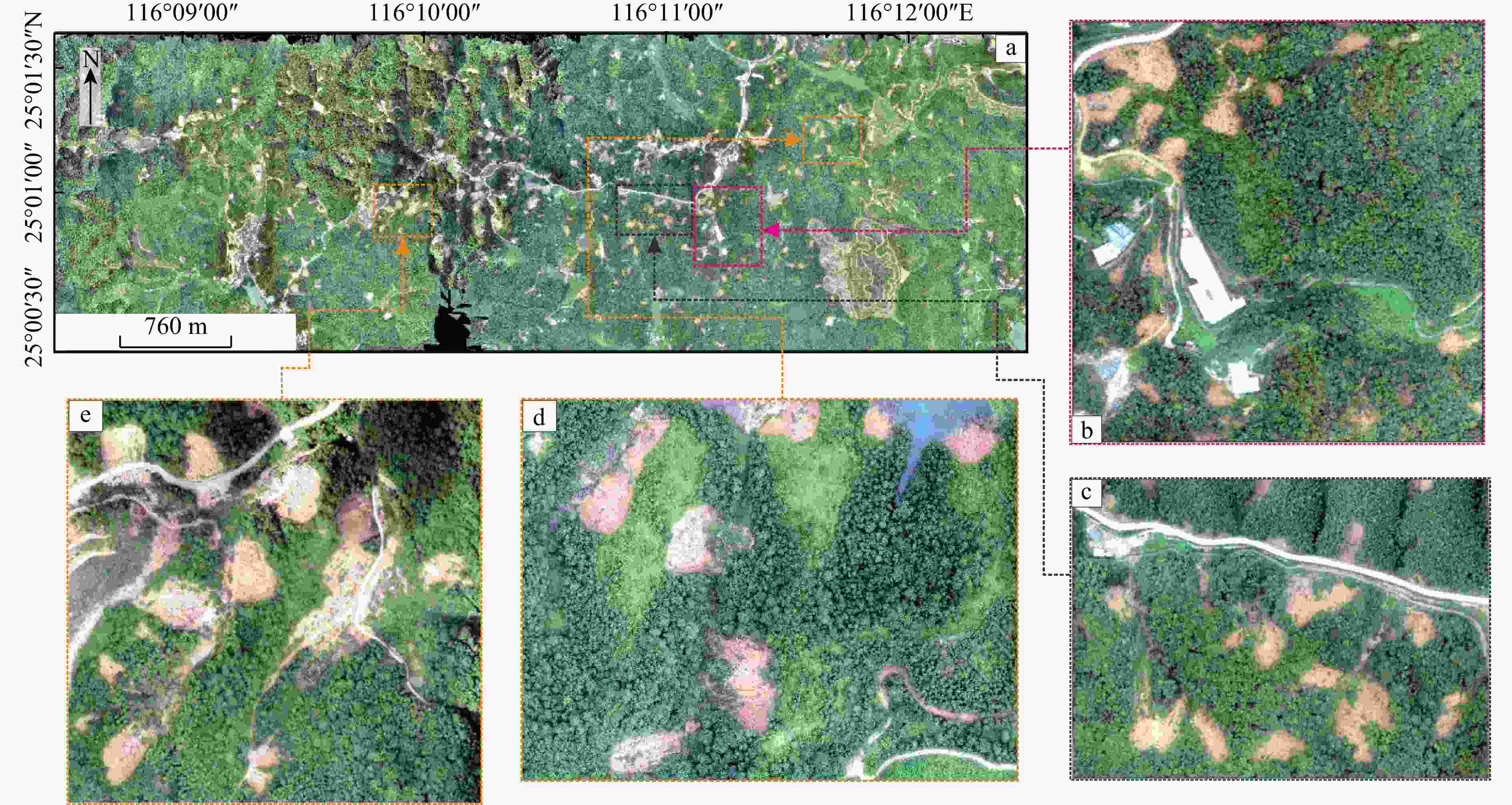
图 4 滑坡航拍影像、训练区与测试区
a.十方镇滑坡群发区航拍影像;b. 快速识别模型训练区; c. 快速识别模型测试区;d,e. 早期识别模型测试区
Figure 4. Aerial image, training area and test area for landslide
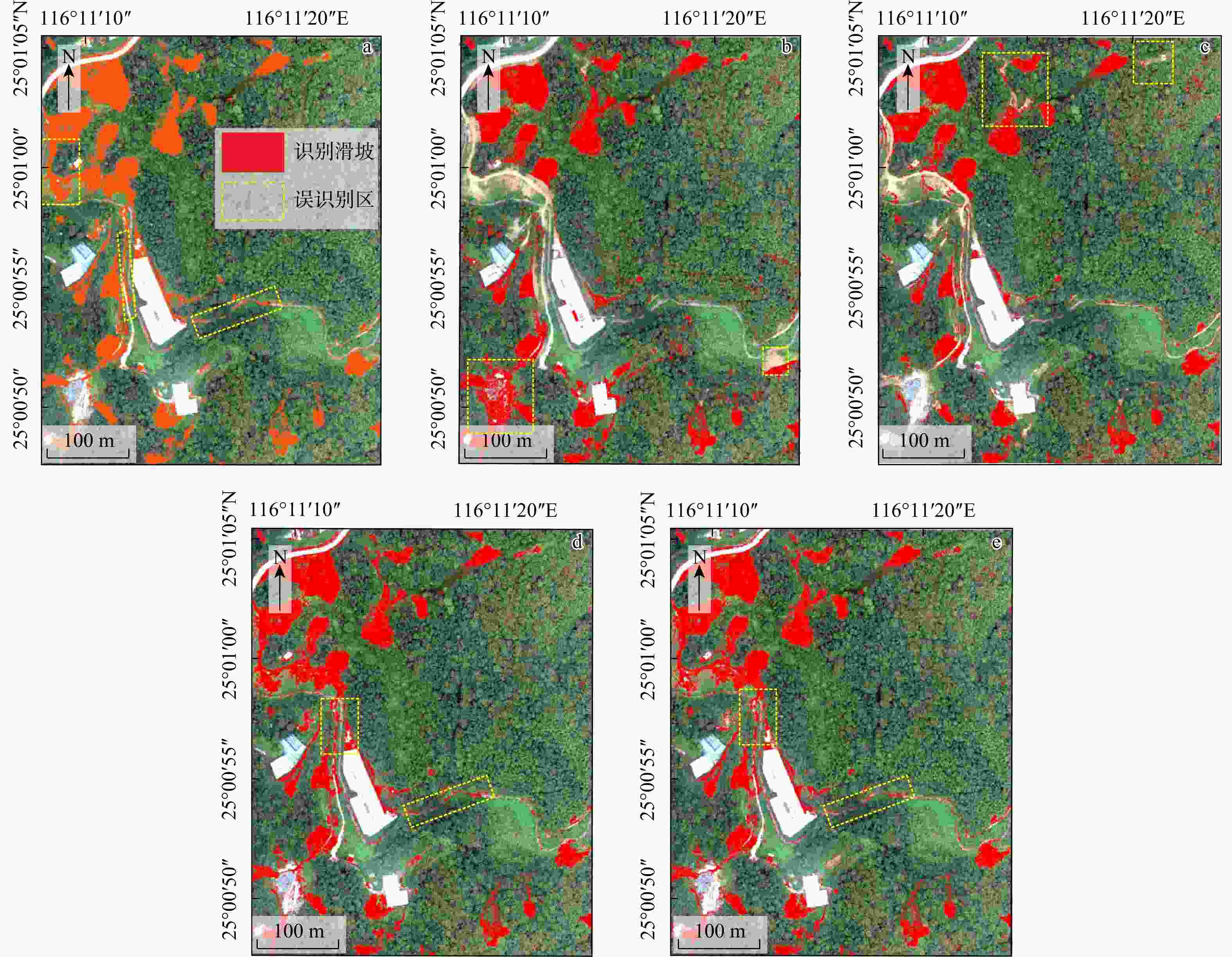
图 6 基于无人机影像的R、G、B三波段与高程、坡度、平面曲率、剖面曲率的两两组合识别结果及相应评价示意图
a. R、G、B三波段识别结果图;b. 影像与高程识别结果图;c. 影像与坡度识别结果图;d. 影像与平面曲率识别结果图;e. 影像与剖面曲率识别结果图
Figure 6. Landslide recognition results and evaluation metrics based on pairwise combinations of R, G and B bands with elevation, slope, plane curvature, profile curvature from UAV imagery
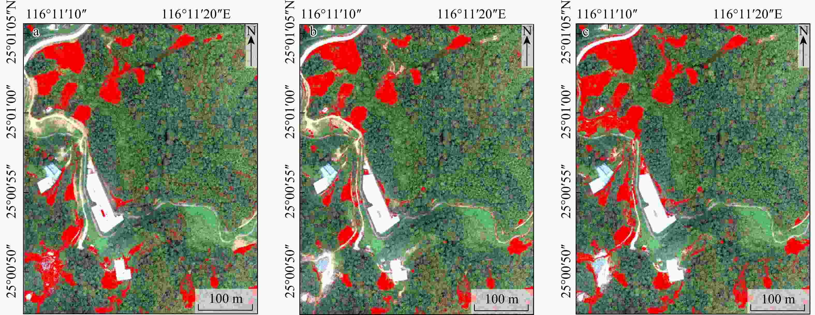
图 7 3种特征组合模型的滑坡识别结果对比图(a. 组合1;b. 组合2;c. 组合3;红色区域为识别滑坡;下同)
Figure 7. Comparison of landslide recognition results using three feature combination models
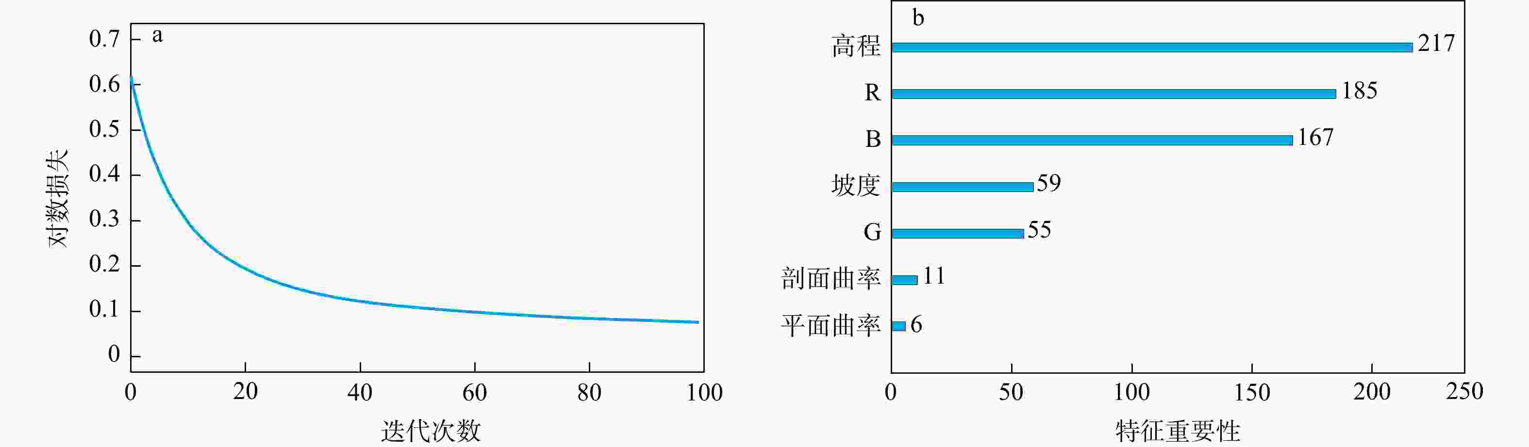
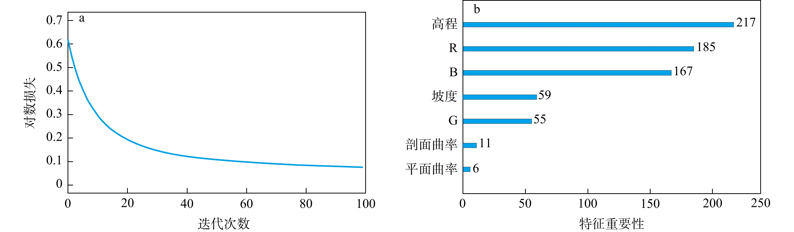
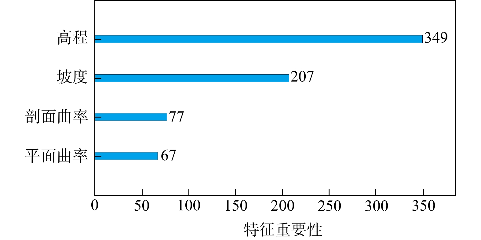
图 8 最佳特征组合模型的损失函数统计图(a)和各特征重要性输出图(b)
Figure 8. Loss function statistics (a) and each feature importance (b) for the best feature combination model
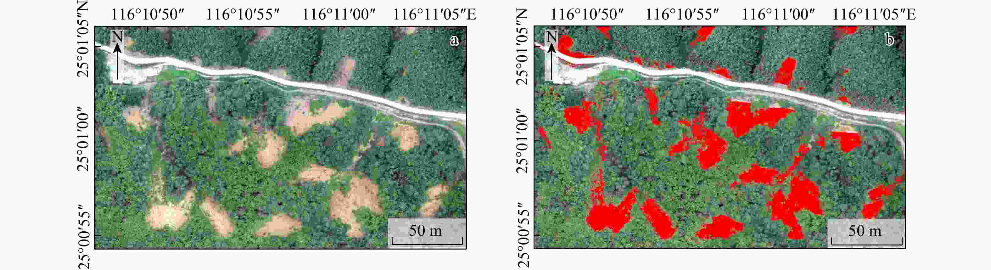
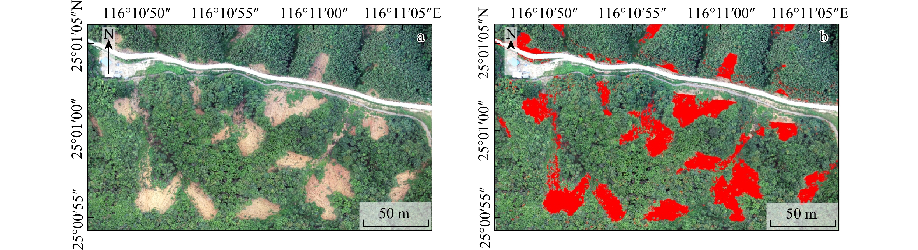
图 9 测试区原始影像 (a) 和最佳识别模型的滑坡自动识别结果 (b)(测试区见图4c)
Figure 9. Original image (a) and landslide automatic recognition results of the best recognition model (b) in the test area
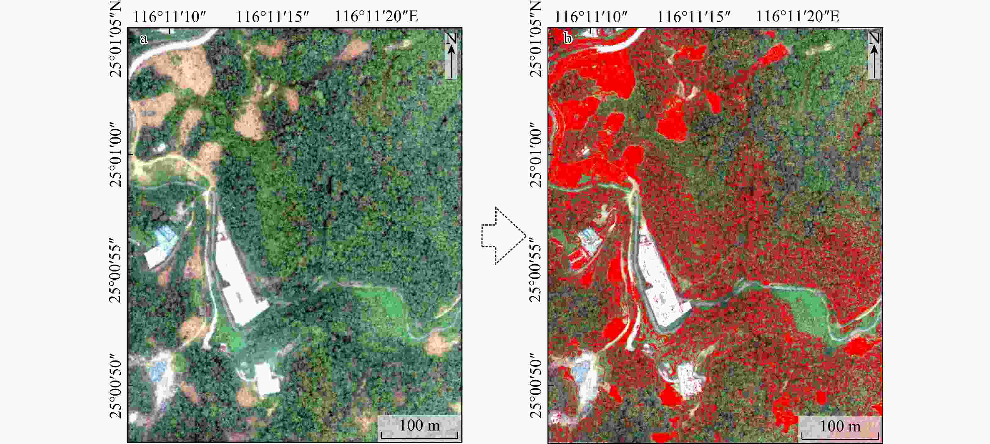
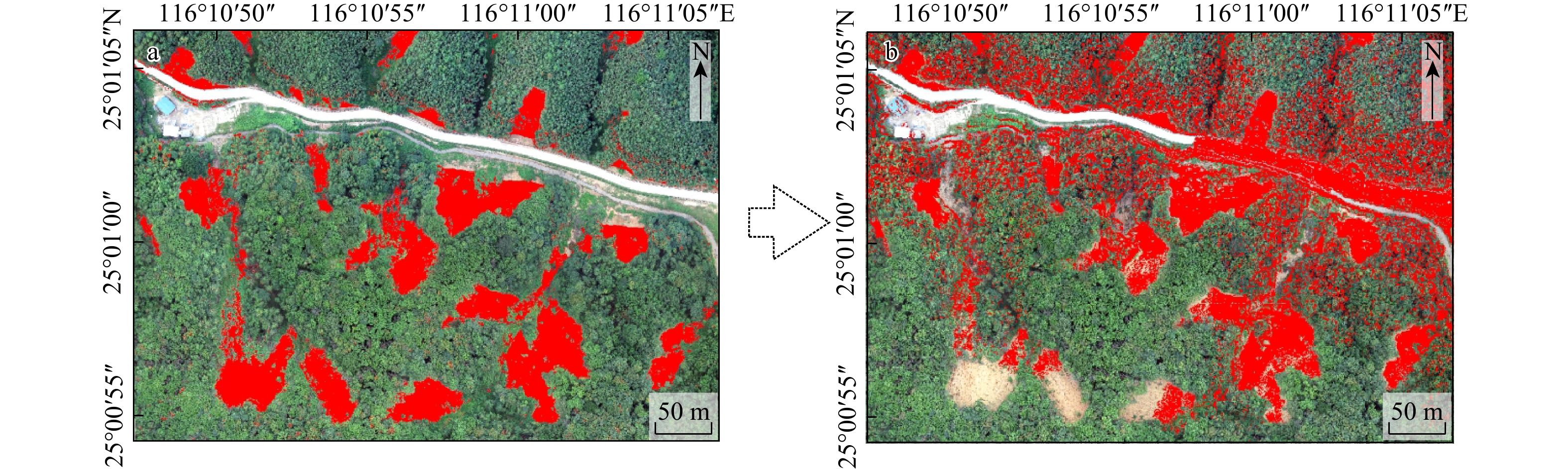
图 10 训练区原始影像(a)和早期识别模型的滑坡识别结果(b)(训练区见图4b)
Figure 10. Original image (a) and landslide recognition results of the early recognition model (b) in the training area

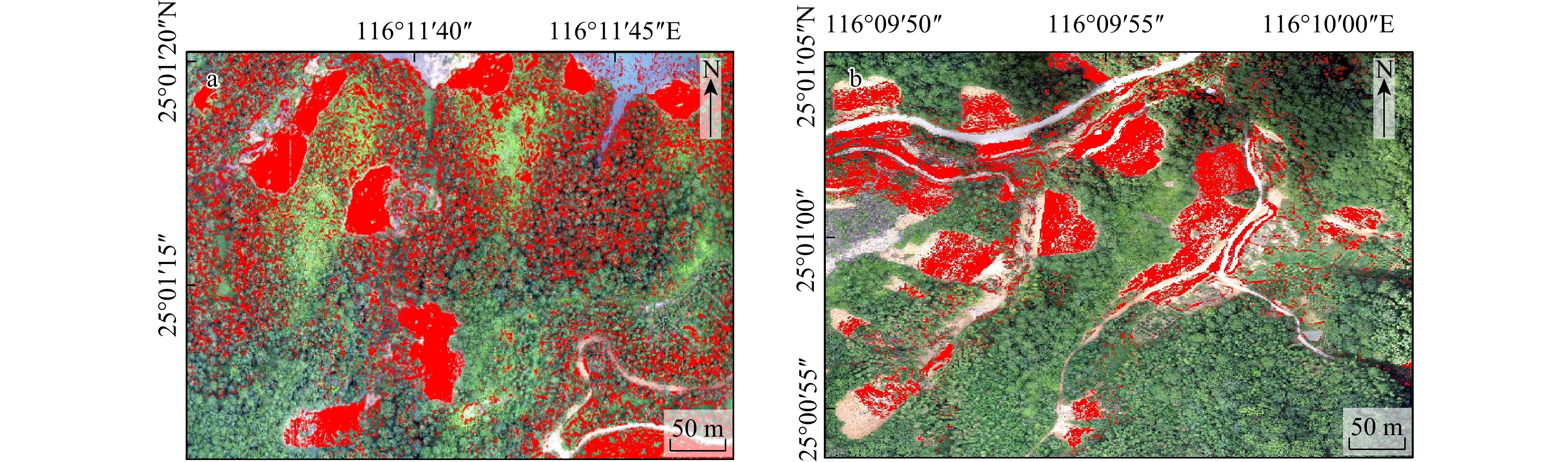
图 11 测试区早期识别模型的滑坡识别结果对比图
a. 未去除影像(R、G、B 波段)信息;b. 去除影像(R、G、B 波段)信息;测试区见图4c
Figure 11. Comparison of landslide recognition results of the early recognition model in the test area
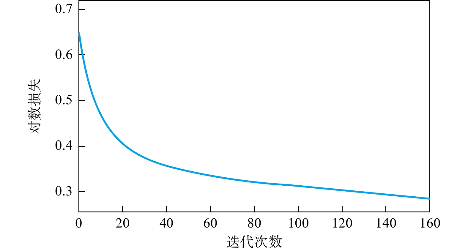
图 12 早期识别模型损失函数统计图
Figure 12. Loss function statistics of the early identification model
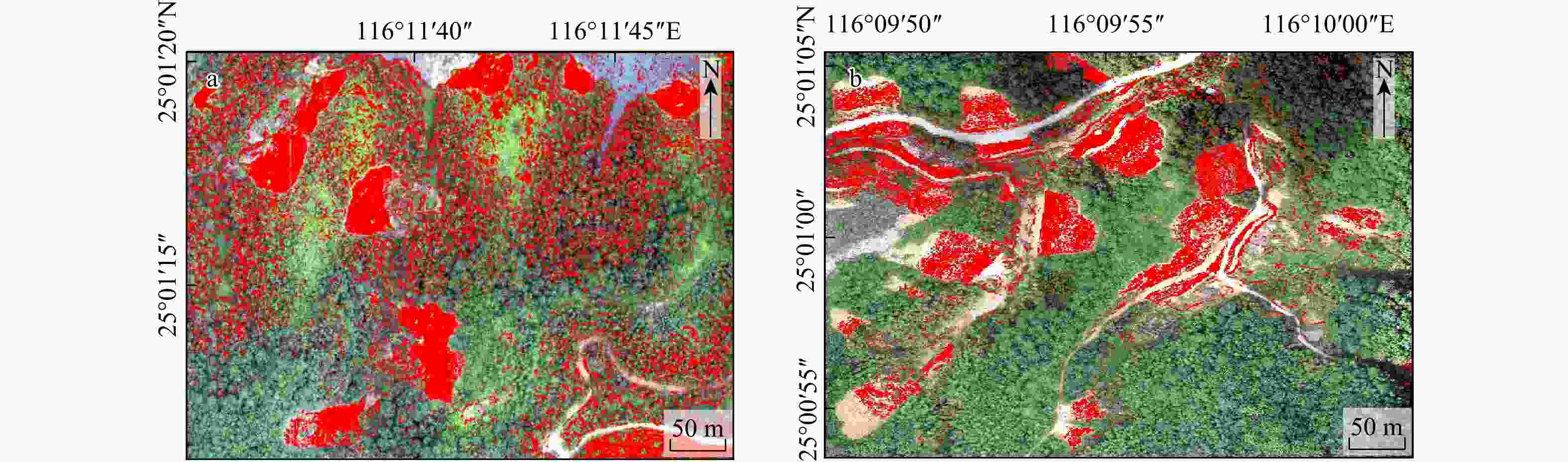
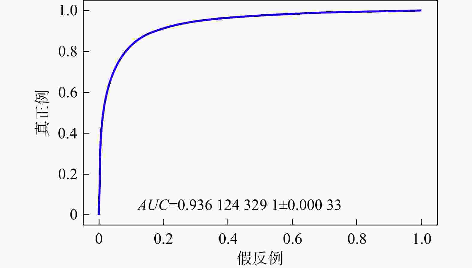
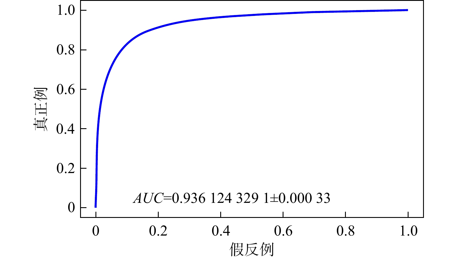
图 14 早期识别模型的受试者工作特征曲线(ROC)
Figure 14. Receiver operating characteristic curve of the early recognition model
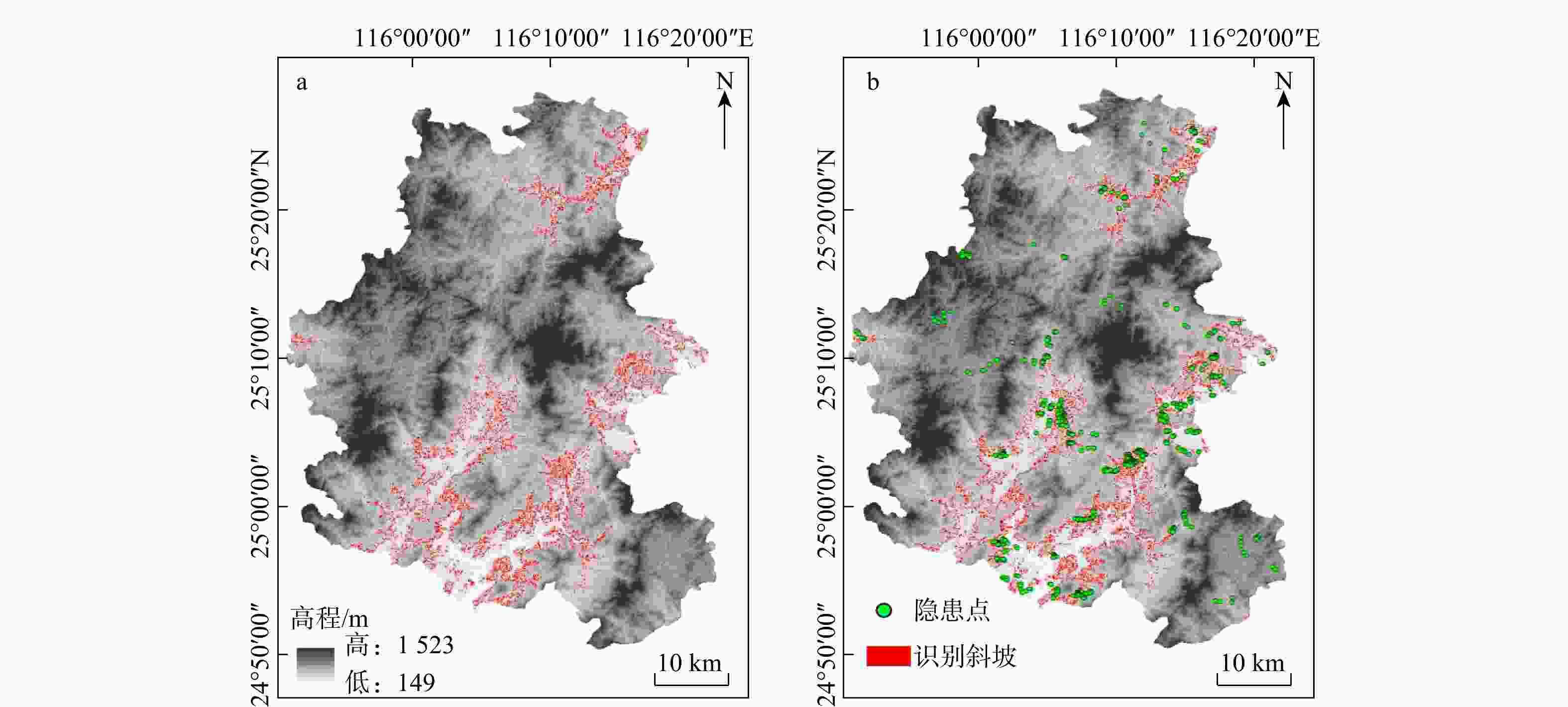
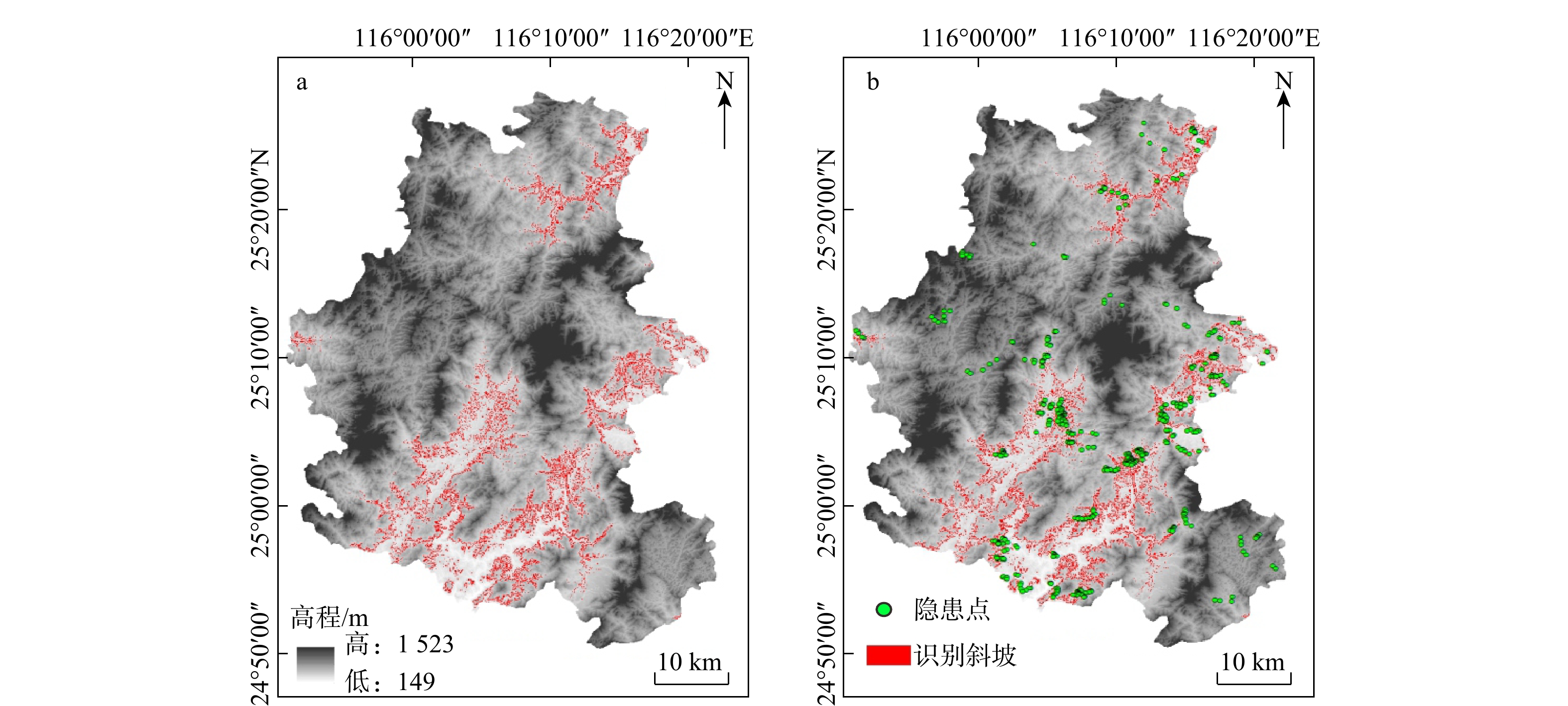
图 16 武平县斜坡灾害隐患点早期识别结果(a)与调查隐患点分布图(b)
Figure 16. Early recognition results of slope hazard points (a) and distribution of surveyed hazard points (b) in Wuping County
表 1 不同特征组合模型的识别结果参数
Table 1. Parameters of landslide recognition results for different feature combination models
参数 Accuracy Precision Recall F1score 组合1 0.972 0.964 0.971 0.967 组合2 0.993 0.979 0.991 0.985 组合3 0.994 0.982 0.992 0.987 注:组合1. RGB波段+高程(DEM)+平面曲率(SOA)+剖面曲率(SOS);组合2. RGB波段+坡度(Slope)+平面曲率(SOA)+剖面曲率(SOS);组合3. RGB波段+高程(DEM)+坡度(Slope)+平面曲率(SOA)+剖面曲率(SOS);Accuracy. 准确率;Precision. 精确率;Recall. 召回率;F1score. 总体得分;下同  下载: 导出CSV
表 2 最佳特征组合模型的测试评价参数
Table 2. Test evaluation parameters for the best feature combination model
参数 Precision Recall F1score 滑坡 0.97 0.99 0.98 非滑坡 1.00 0.99 1.00
下载: 导出CSV
表 3 早期识别模型的评价参数
Table 3. Evaluation parameters of the early recognition model
参数 Accuracy Precision F1score Recall 灾害体 0.86 0.93 0.86 0.86
下载: 导出CSV
表 4 武平县全域模型测试评价参数
Table 4. Model test evaluation parameters in Wuping County
参数 Accuracy Precision F1score Recall 隐患点 0.80 0.89 0.84 0.80 非隐患点 0.85 0.83 0.84 0.86
下载: 导出CSV
-
[1] ZHOU D Y, ZHANG Z, LI J C, et al. Seepage-stress coupled modeling for rainfall induced loess landslide[J]. Theoretical and Applied Mechanics Letters, 2019, 9(1): 7-13. doi: 10.1016/j.taml.2019.02.006 [2] LI Z, HE Y J, LI H E, et al. Antecedent rainfall induced shallow landslide: A case study of Yunnan landslide, China[J]. Scientia Iranica, Transactions A: Civil Engineering, 2019, 26(1): 202-212. [3] 佚名. 河南郑州“7·20”特大暴雨灾害调查报告公布[J]. 中国应急管理, 2022(2): 4.Anon. The release of the investigation report on the severe rainstorm disaster in Zhengzhou, Henan on July 20[J]. China Emergency Management, 2022(2): 4. (in Chinese with English abstract [4] 吴伟伟, 胥涛, 高志强, 等. 山西晋中地区“2021.10”暴雨特征与洪灾分析[J]. 中国防汛抗旱, 2022, 32(12): 82-88. doi: 10.16867/j.issn.1673-9264.2022083WU W W, XU T, GAO Z Q, et al. Rainstorm characteristics and flood disaster analysis of “2021.10” in Jinzhong area, Shanxi Province[J]. China Flood & Drought Management, 2022, 32(12): 82-88. (in Chinese with English abstract doi: 10.16867/j.issn.1673-9264.2022083 [5] 李天毅, 戴宁, 丛佩娟, 等. “23·7” 京津冀暴雨洪水特性分析: 以河北省临城县为例[J/OL]. 水土保持通报: 1-13 [2026-01-14]. https://link.cnki.net/doi/10.13961/j.cnki.stbctb.2024.02.017.LI T Y, DAI N, CONG P J, et al. Analysis of rainstorm flood characteristics in “23·7” Beijing-Tianjin-Hebei: A case study of Lincheng County, Hebei Province[J/OL]. Bulletin of Soil and Water Conservation: 1-13 [2026-01-14]. https://link.cnki.net/doi/10.13961/j.cnki.stbctb.2024.02.017.(in Chinese with English abstract [6] LI G E, HU B, LI H, et al. Early identifying and monitoring landslides in Guizhou Province with InSAR and optical remote sensing[J]. Journal of Sensors, 2021, 2021(1): 6616745. doi: 10.1155/2021/6616745 [7] WANG Y A, LIU D L, DONG J, et al. On the applicability of satellite SAR interferometry to landslide hazards detection in hilly areas: A case study of Shuicheng, Guizhou in Southwest China[J]. Landslides, 2021, 18(7): 2609-2619. [8] DAI K R, FENG Y, ZHUO G C, et al. Applicability analysis of potential landslide identification by InSAR in Alpine-canyon terrain: Case study on Yalong River[J]. IEEE Journal of Selected Topics in Applied Earth Observations and Remote Sensing, 2018, 15: 2110-2118. [9] LIANG J T, DONG J H, ZHANG S, et al. Discussion on InSAR identification effectivity of potential landslides and factors that influence the effectivity[J]. Remote Sensing, 2022, 14(8): 1952. [10] 许强, 陆会燕, 李为乐, 等. 滑坡隐患类型与对应识别方法[J]. 武汉大学学报(信息科学版), 2022, 47(3): 377-387.XU Q, LU H Y, LI W L, et al. Types of potential landslide and corresponding identification technologies[J]. Geomatics and Information Science of Wuhan University, 2022, 47(3): 377-387. (in Chinese with English abstract [11] LIU Y, WU L Z. Geological disaster recognition on optical remote sensing images using deep learning[J]. Procedia Computer Science, 2016, 91: 566-575. [12] SAMEEN M I, PRADHAN B, LEE S. Application of convolutional neural networks featuring Bayesian optimization for landslide susceptibility assessment[J]. Catena, 2020, 186: 104249. [13] GUARNIERI A, MASIERO A, VETTORE A, et al. Evaluation of the dynamic processes of a landslide with laser scanners and Bayesian methods[J]. Geomatics, Natural Hazards and Risk, 2015, 6(5/6/7): 614-634. [14] 邬礼扬, 殷坤龙, 曾韬睿, 等. 不同栅格尺寸下输电线路地质灾害易发性评价[J]. 地质科技通报, 2024, 43(1): 241-252.WU L Y, YIN K L, ZENG T R, et al. Evaluation of geological disaster susceptibility of transmission lines under different grid resolutions[J]. Bulletin of Geological Science and Technology, 2024, 43(1): 241-252. (in Chinese with English abstract [15] NHU V H, MOHAMMADI A, SHAHABI H, et al. Landslide detection and susceptibility modeling on Cameron Highlands (Malaysia): A comparison between random forest, logistic regression and logistic model tree algorithms[J]. Forests, 2020, 11(8): 830. [16] DOU J, YUNUS A P, BUI D T, et al. Improved landslide assessment using support vector machine with bagging, boosting, and stacking ensemble machine learning framework in a mountainous watershed, Japan[J]. Landslides, 2020, 17(3): 641-658. [17] 吴季寰, 张春山, 孟华君, 等. 抚顺西露天矿区滑坡易发性评价与时空特征分析[J]. 地质力学学报, 2021, 27(3): 409-417.WU J H, ZHANG C S, MENG H J, et al. Temporal and spatial characteristics of landslide susceptibility in the west open-pit mining area, Fushun, China[J]. Journal of Geomechanics, 2021, 27(3): 409-417. (in Chinese with English abstract [18] CHEN F, YU B, LI B. A practical trial of landslide detection from single-temporal Landsat8 images using contour-based proposals and random forest: A case study of national Nepal[J]. Landslides, 2018, 15(3): 453-464. [19] BUI D T, TSANGARATOS P, NGUYEN V T, et al. Comparing the prediction performance of a deep learning neural network model with conventional machine learning models in landslide susceptibility assessment[J]. Catena, 2020, 188: 104426. [20] PANG D D, LIU G, HE J, et al. Automatic remote sensing identification of co-seismic landslides using deep learning methods[J]. Forests, 2022, 13(8): 1213. [21] WANG Y, WANG X F, JIAN J F. Remote sensing landslide recognition based on convolutional neural network[J]. Mathematical Problems in Engineering, 2019, 2019(1): 8389368. [22] 高瑞源. 基于机器学习方法的区域泥石流易发性评价研究[D]. 长春: 吉林大学, 2023.GAO R Y. Study on regional debris flow susceptibility evaluation based on machine learning methods[D]. Changchun: Jilin University, 2023. (in Chinese with English abstract [23] 冀全伟, 王文磊, 刘治博, 等. 一种基于机器学习算法的岩性填图方法[J]. 地质力学学报, 2021, 27(3): 339-349.JI Q W, WANG W L, LIU Z B, et al. A machine learning-based lithologic mapping method[J]. Journal of Geomechanics, 2021, 27(3): 339-349. (in Chinese with English abstract [24] DING A, ZHANG Q, ZHOU X, et al. Automatic identification of landslide based on CNN and texture change detection[C]//Anon. Proceedings of the Chinese Association of Automation (YAC), Youth Academic Annual Conference. [S. l. ], IEEE, 2016: 444-448. [25] WANG H J, ZHANG L M, YIN K S, et al. Landslide identification using machine learning[J]. Geoscience Frontiers, 2021, 12(1): 351-364. [26] KEYPORT R N, OOMMEN T, MARTHA T R, et al. A comparative analysis of pixel- and object-based detection of landslides from very high-resolution images[J]. International Journal of Applied Earth Observation and Geoinformation, 2018, 64: 1-11. [27] GHORBANZADEH O, BLASCHKE T, GHOLAMNIA K, et al. Evaluation of different machine learning methods and deep-learning convolutional neural networks for landslide detection[J]. Remote Sensing, 2019, 11(2): 196. [28] 福建省煤田地质局, 福建省121地质大队. 武平县1∶5万地质灾害调查与风险评价成果报告[R]. 福州: 福建省煤田地质局, 福建省121地质大队, 2021.Fujian 121 Geological Brigade, Fujian Provincial Coal Geology Bureau. Report on the results of 1∶50 000 geological hazard investigation and risk assessment in Wuping County[R]. Fujian 121 Geological Brigade, Fujian Provincial Coal Geology Bureau, 2021. (in Chinese) [29] LIU Y H, HUANG J B, XIAO R H, et al. Research on a regional landslide early-warning model based on machine learning: A case study of Fujian Province, China[J]. Forests, 2022, 13(12): 2182. [30] WANG T, LI R, CHEN C, et al. Kinetic analysis of rainfall-induced landslides in May 2022 in Wuping, Fujian, SE China[J]. Water, 2024, 16(21): 3018. [31] 罗常伟, 王双双, 尹峻松, 等. 集成学习研究现状及展望[J]. 指挥与控制学报, 2023, 9(1): 1-8.LUO C W, WANG S S, YIN J S, et al. Research status and prospect of ensemble learning[J]. Journal of Command and Control, 2023, 9(1): 1-8. (in Chinese with English abstract [32] LEO B. Bagging predictors[J]. Machine Learning, 1996, 24(2): 123-140. [33] 徐继伟, 杨云. 集成学习方法: 研究综述[J]. 云南大学学报(自然科学版), 2018, 40(6): 1082-1092. doi: 10.7540/j.ynu.20180455XU J W, YANG Y. A survey of ensemble learning approaches[J]. Journal of Yunnan University (Natural Sciences Edition), 2018, 40(6): 1082-1092. (in Chinese with English abstract doi: 10.7540/j.ynu.20180455 [34] 李航. 统计学习方法[M]. 北京: 清华大学出版社, 2012.LI H. Statistical learning method[M]. Beijing: Tsinghua University Press, 2012. (in Chinese) [35] XIE M W, HUANG J X, WANG L W, et al. Early landslide detection based on D-InSAR technique at the Wudongde hydropower reservoir[J]. Environmental Earth Sciences, 2016, 75(8): 717. [36] REN T H, GONG W P, GAO L, et al. An interpretation approach of ascending-descending SAR data for landslide identification[J]. Remote Sensing, 2022, 14(5): 1299. [37] VAN NATIJNE A L, BOGAARD T A, VAN LEIJEN F J, et al. World-wide InSAR sensitivity index for landslide deformation tracking[J]. International Journal of Applied Earth Observation and Geoinformation, 2022, 111: 102829. [38] NIU C, YIN W P, XUE W, et al. Multi-window identification of landslide hazards based on InSAR technology and factors predisposing to disasters[J]. Land, 2023, 12(1): 173. [39] 王灿星, 朱杰勇, 喻聪骏, 等. 基于皮尔逊Ⅲ型曲线的不同降雨工况下的崩滑地质灾害危险性评价[J]. 地质科技通报, 2025, 44(1): 194-204.WANG C X, ZHU J Y, YU C J, et al. Risk assessment of landslide geological hazards under different rainfall conditions based on the Pearson Ⅲ curves[J]. Bulletin of Geological Science and Technology, 2025, 44(1): 194-204. (in Chinese with English abstract [40] 李星, 杨赛, 李远耀, 等. 面向区域滑坡易发性精细化评价的改进斜坡单元法[J]. 地质科技通报, 2023, 42(3): 81-92.LI X, YANG S, LI Y Y, et al. Improved slope unit method for fine evaluation of regional landslide susceptibility[J]. Bulletin of Geological Science and Technology, 2023, 42(3): 81-92. (in Chinese with English abstract [41] CHEN B, LI Z H, SONG C, et al. Automatic detection of active geohazards with millimeter-to-meter-scale deformation and quantitative analysis of factors influencing spatial distribution: A case study in the Hexi Corridor, China[J]. International Journal of Applied Earth Observation and Geoinformation, 2024, 131: 103995. -

 下载:
下载:


 点击查看大图

计量
- 文章访问数: 435
- PDF下载量: 159
- 被引次数: 0

