
 投审稿入口
投审稿入口

Exploration of groundwater table spatial estimation in Jiangsu Province based on machine learning and multi-source data fusion
-
摘要:
确定区域潜水位的空间分布对地下水资源管理及地下水污染防治具有重要意义。由于地下水监测井数量有限且空间分布不均,传统插值方法难以准确刻画区域尺度的潜水流场,传统回归方法难以有效捕捉不同影响因素与地下水位间的复杂非线性关系,机器学习方法在表征强非线性关系方面具有显著的优势。综合利用高程、植被覆盖度、降雨量、地表水距离、地表温度、土壤含水量等多源数据,基于机器学习方法构建区域潜水位预测模型。收集了江苏省953个枯水期潜水位实测及补充点位,机器学习模型在测试数据集的决定系数为0.91。模型预测的江苏省潜水流场,所反映的地表水−地下水补排关系与实际水文规律基本一致。选取3个典型示范场区进行验证,模型预测流向与实际相符。研究构建的深度神经网络模型可有效应用于江苏省稳态潜水位空间分布估计,为区域尺度环境影响评价、地下水监测优化提供决策支持。
Abstract:ObjectiveCharacterizing the spatial distribution of the regional groundwater table is critical for effective groundwater management and pollution control. However, the limited number and uneven distribution of observation wells in many regions, including Jiangsu Province, China, make it difficult for traditional interpolation or physically based numerical models to provide reliable predictions. Interpolation methods such as Kriging depend heavily on well coverage, which restricts their applicability in data-scarce areas, while numerical models require large amounts of hydrogeological parameters and boundary conditions that are often unavailable in practice.
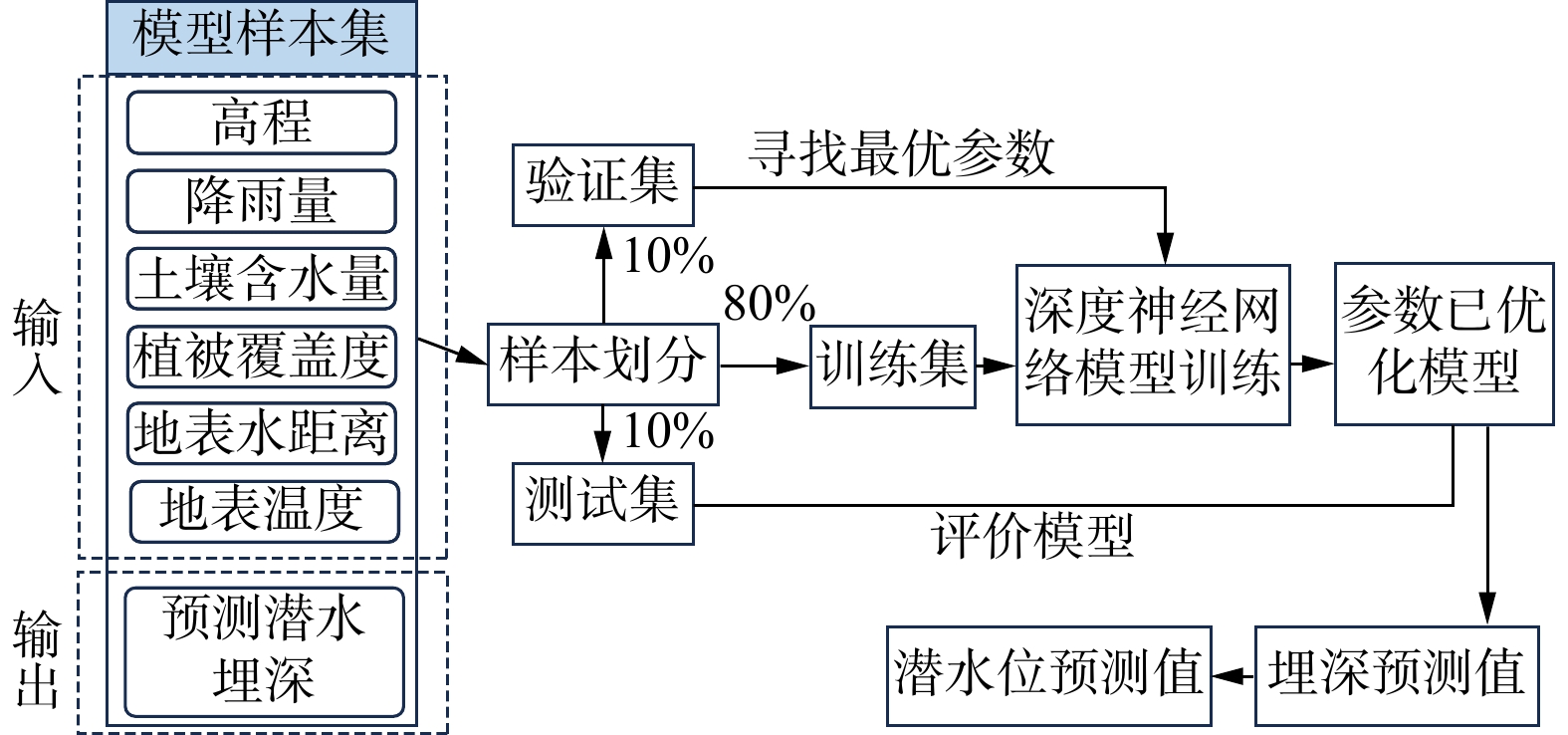
MethodsTo address these limitations, this study develops a machine learning-based framework that integrates multi-source data, including elevation, vegetation coverage, rainfall, distance from surface water, land surface temperature, and soil moisture. A dataset of 953 groundwater observations collected during the dry season, complemented by surface water levels and published measurements, was compiled and standardized. A deep neural network (DNN) was trained using 80% of the data, validated on 10%, and tested on the remaining 10%.
ResultsThe model achieved a determination coefficient (
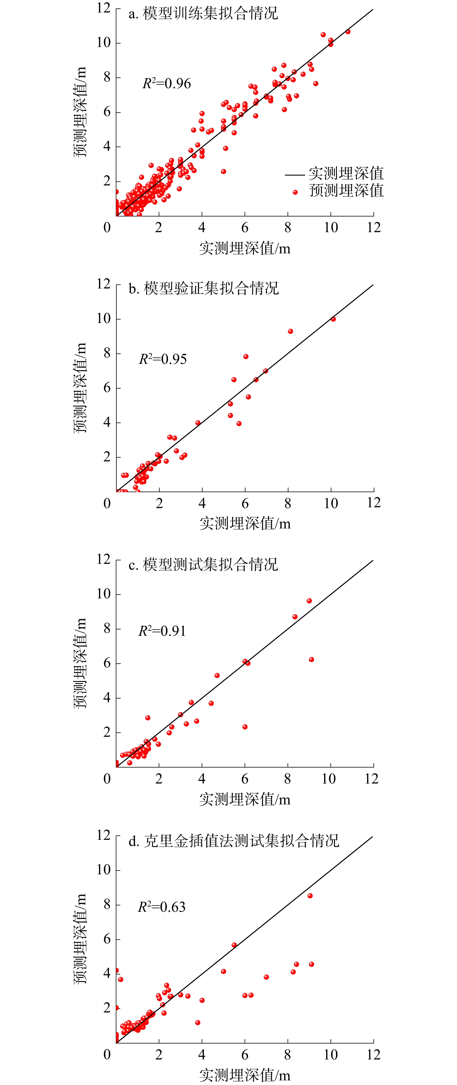
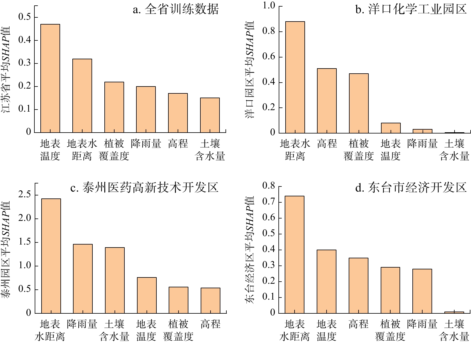
R 2) of 0.91 on the test dataset, substantially outperforming ordinary Kriging (R 2=0.63). The predicted groundwater table maps revealed clear large-scale patterns consistent with hydrogeological understanding, including a west-to-east flow gradient and discharge into the Yangtze River, Taihu Lake, and the East China Sea. Compared with nationwide groundwater models, the proposed approach provided finer spatial resolution and captured more local flow features. Validation in three representative demonstration areas-a coastal industrial park, a riverside development zone, and a cross-hydrogeological unit-confirmed that predicted groundwater flow directions matched observed values, even where monitoring wells were sparse. To enhance interpretability, Shapley additive explanations (SHAP) analysis was applied, which revealed that land surface temperature, vegetation cover, and distance to surface water exerted dominant influences at the provincial scale, while site-specific analyses emphasized the importance of local hydrological connectivity.ConclusionOverall, the machine learning framework developed in this study provides an efficient and scalable tool for estimating groundwater table distributions in data-limited regions. By integrating diverse environmental factors, this approach improves predictive accuracy, enhances the spatial resolution of groundwater flow mapping, and offers insights into governing factors. The results highlight the potential of combining big data and artificial intelligence methods to support groundwater monitoring optimization, regional environmental impact assessments, and sustainable water resource management.
-
Key words:
- groundwater level /
- deep neural network /
- big data /
- groundwater management /
- machine learning /
- Jiangsu Province
-

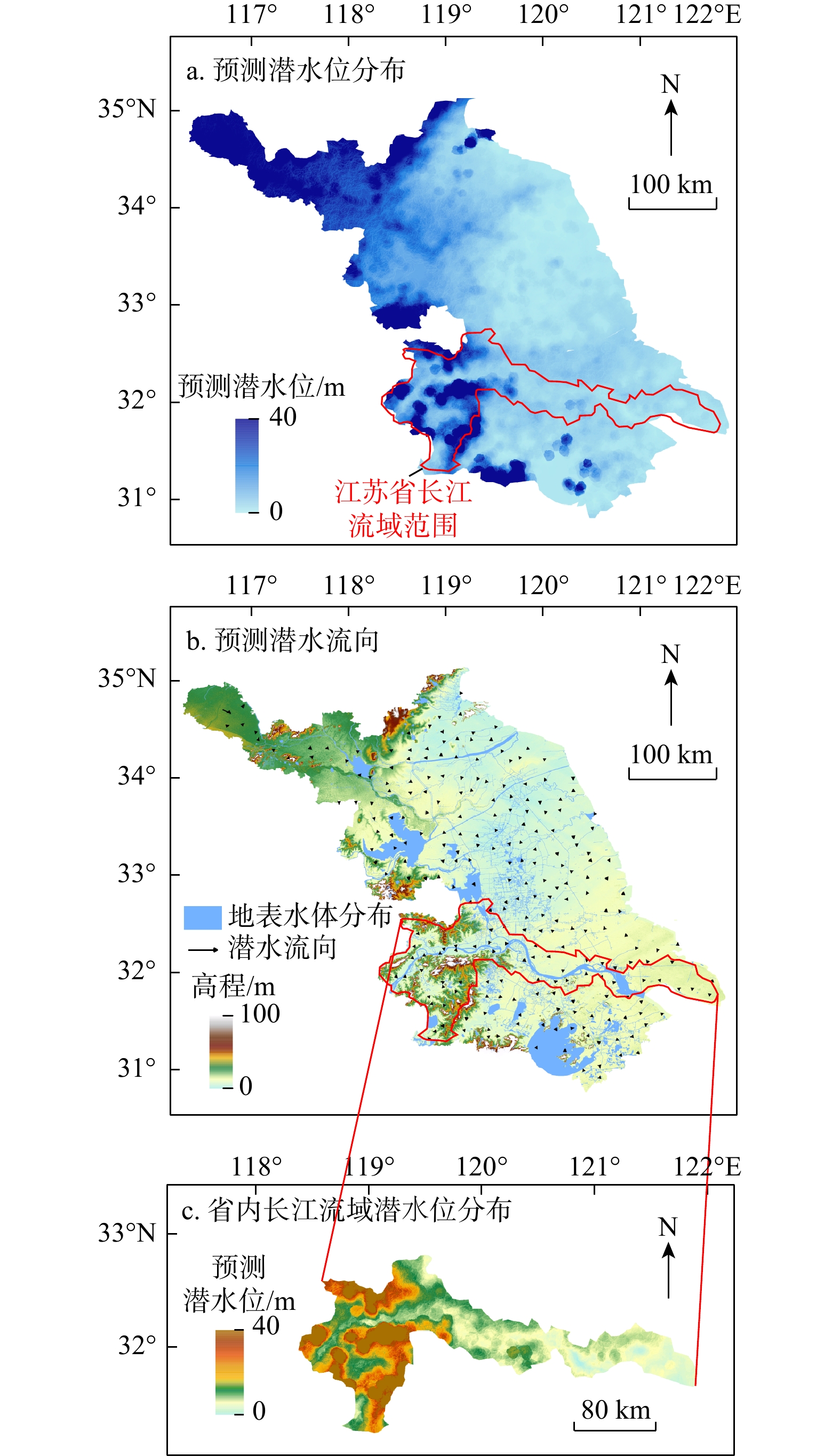
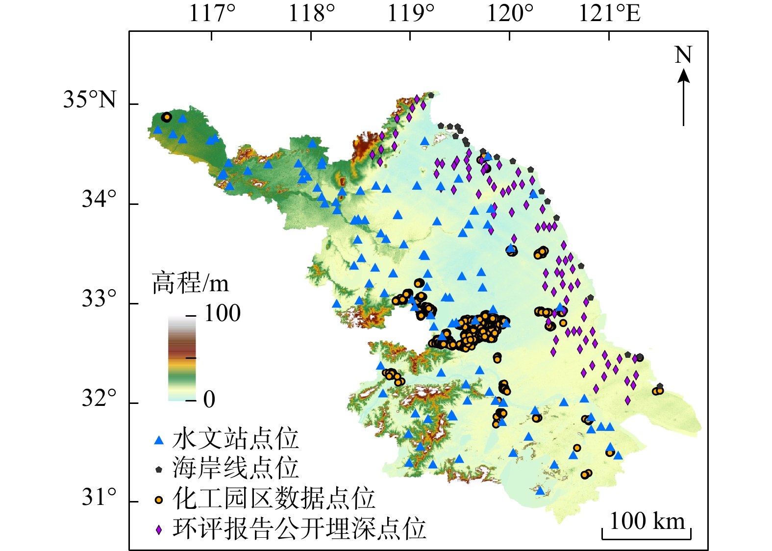
图 1 研究区水位观测点分布图
Figure 1. Distribution of groundwater level observation points in the study area

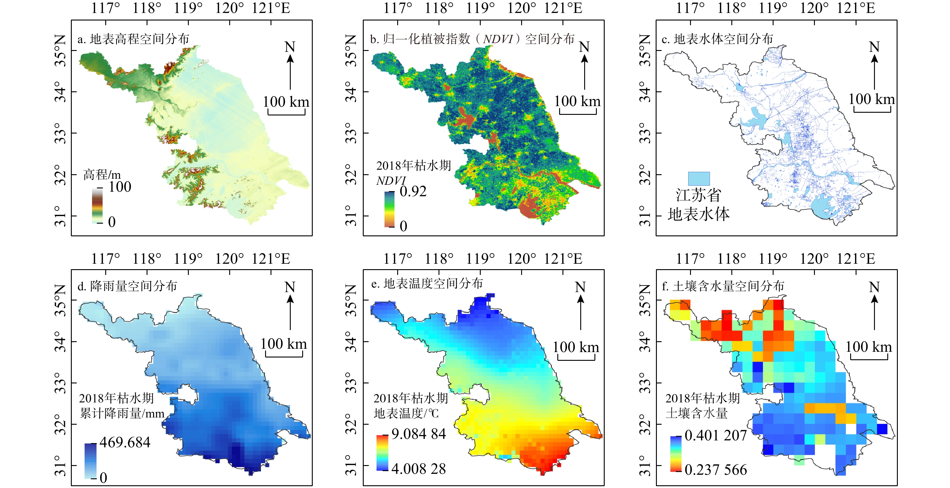
图 2 江苏省6类影响要素空间分布图
Figure 2. Spatial distribution of six influencing factors in Jiangsu Province

图 4 模型拟合情况与克里金插值结果对比图
Figure 4. Comparison of model fitting and Kriging interpolation results

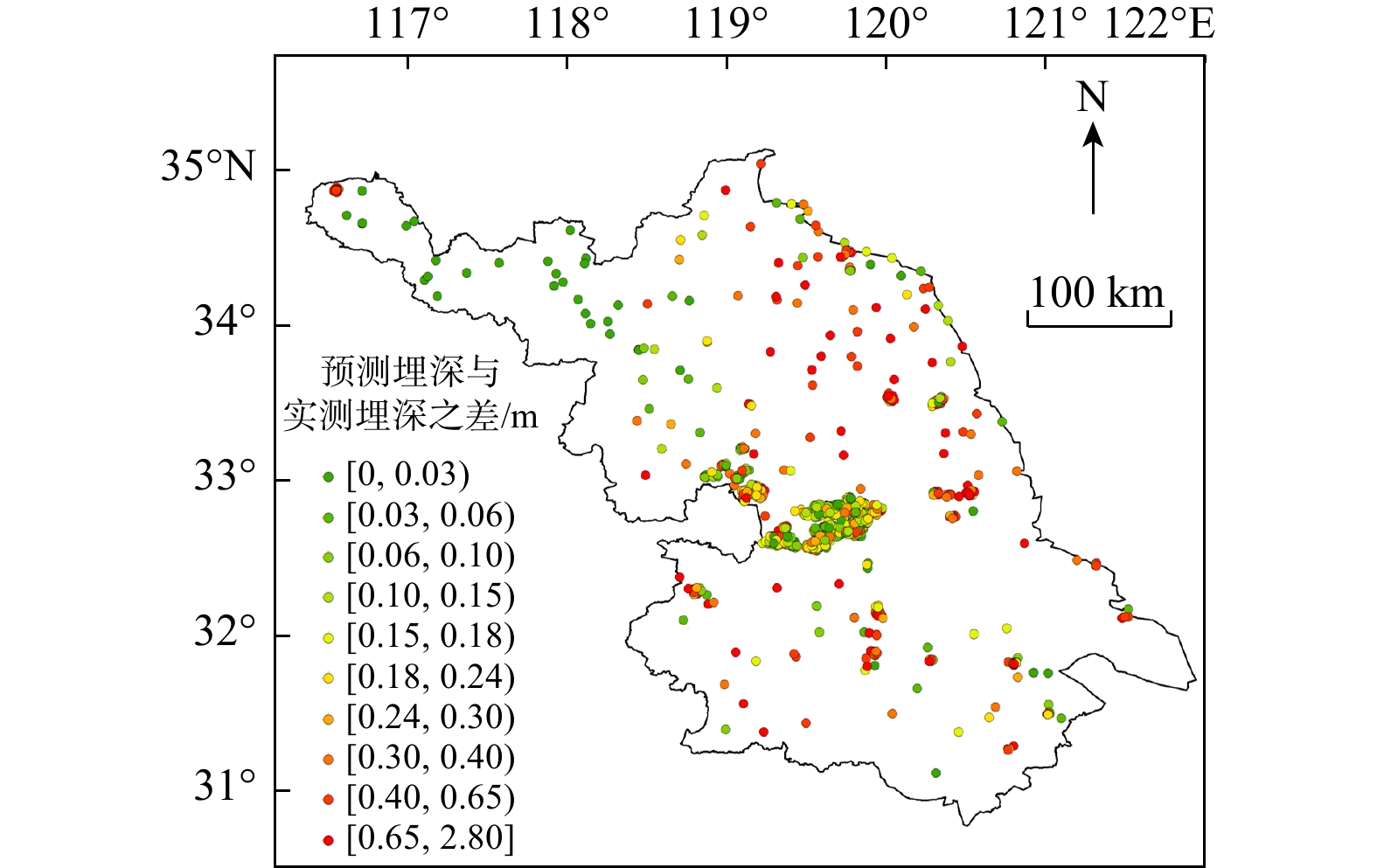
图 5 江苏省点位预测值与实测值之差空间分布图
Figure 5. Spatial distribution of difference between predicted and measured point values in Jiangsu Province

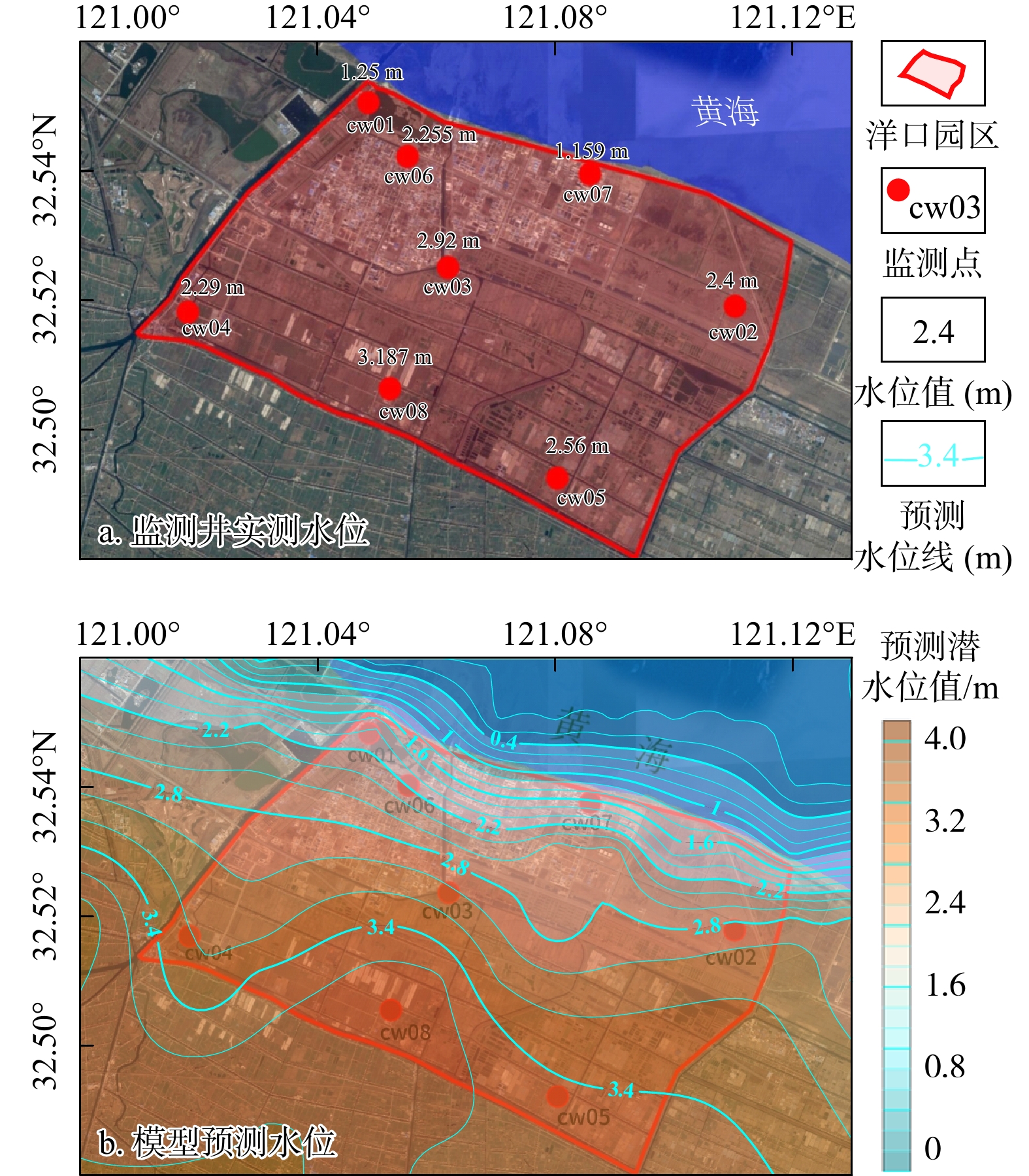
图 8 洋口园区流场对比验证图
Figure 8. Comparison of estimated and measured flow fields in Yangkou industrial Park

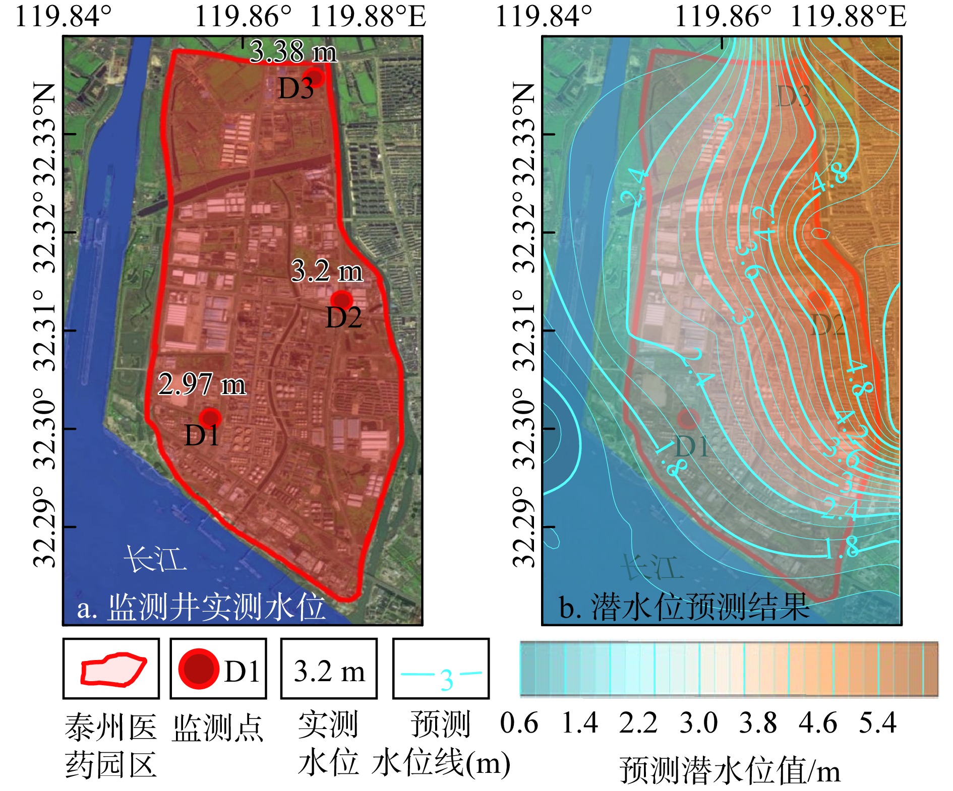
图 9 泰州医药园区流场对比验证图
Figure 9. Comparison of estimated and measured flow fields in Taizhou medical high-tech development zone

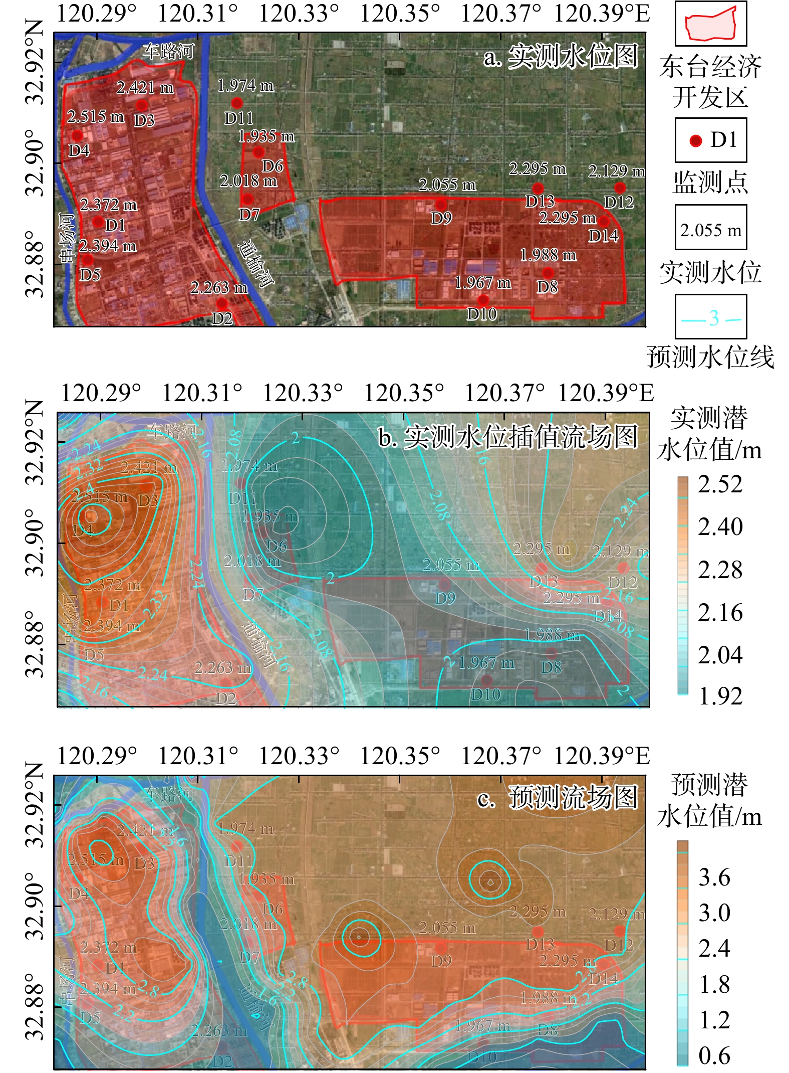
图 10 东台经济开发区流场预测对比验证
Figure 10. Comparison of estimated and measured flow fields in Dongtai economic development zone
表 1 影响要素数据属性表
Table 1. Data attribute of input factors
数据名称 来源平台 数据精度 ALOS卫星观测高程数据 美国航天航空局(NASA) https://www.nasa.gov/ 12.5 m 全国水体分布矢量数据 Open street map https://www.openstreetmap.org/ 30 m 归一化植被指数(NDVI) 地理国情监测云平台 http://www.dsac.cn/ 1 km 土壤含水量 科学数据银行ScienceDB (scidb.cn) 0.5° 地表温度数据 国家青藏高原科学数据中心 https://data.tpdc.ac.cn/product 0.1° 2018年枯水季降雨量数据 国家青藏高原科学数据中心 https://data.tpdc.ac.cn/product 0.1° 水位监测数据 硕博论文(CNKI)[30-32] https://www.cnki.net/ −  下载: 导出CSV
-
[1] BUCHANAN S, TRIANTAFILIS J. Mapping water table depth using geophysical and environmental variables[J]. Ground Water, 2009, 47(1): 80-96. doi: 10.1111/j.1745-6584.2008.00490.x [2] BUECHLER S, MEKALA G D. Local responses to water resource degradation in India: Groundwater farmer innovations and the reversal of knowledge flows[J]. The Journal of Environment & Development, 2005, 14(4): 410-438. doi: 10.1177/1070496505281840 [3] AO C, ZENG W Z, WU L F, et al. Time-delayed machine learning models for estimating groundwater depth in the Hetao Irrigation District, China[J]. Agricultural Water Management, 2021, 255: 107032. doi: 10.1016/j.agwat.2021.107032 [4] ALLEY W M, TAYLOR C J. The value of long-term ground water level monitoring[J]. Ground Water, 2001, 39(6): 801. doi: 10.1111/j.1745-6584.2001.tb02466.x [5] JÚNEZ-FERREIRA H E, HERNÁNDEZ-HERNÁNDEZ M A, HERRERA G S, et al. Assessment of changes in regional groundwater levels through spatio-temporal Kriging: Application to the southern Basin of Mexico aquifer system[J]. Hydrogeology Journal, 2023, 31(6): 1405-1423. doi: 10.1007/s10040-023-02681-y [6] MIRZAIE-NODOUSHAN F, BOZORG-HADDAD O, LOÁICIGA H A. Optimal design of groundwater-level monitoring networks[J]. Journal of Hydroinformatics, 2017, 19(6): 920-929. doi: 10.2166/hydro.2017.044 [7] GUEKIE SIMO A T, MARACHE A, LASTENNET R, et al. Geostatistical investigations for suitable mapping of the water table: The Bordeaux case (France)[J]. Hydrogeology Journal, 2016, 24(1): 231-248. doi: 10.1007/s10040-015-1316-4 [8] MALEKZADEH M, KARDAR S, SHABANLOU S. Simulation of groundwater level using MODFLOW, extreme learning machine and Wavelet-Extreme Learning Machine models[J]. Groundwater for Sustainable Development, 2019, 9: 100279. doi: 10.1016/j.gsd.2019.100279 [9] 郑凌云, 张永祥, 贾瑞涛, 等. 基于GMS的北京市朝阳区地下水环境数值模拟与预测分析[J]. 水利水电技术(中英文), 2022(1): 114-123. doi: 10.13928/j.cnki.wrahe.2022.01.012ZHENG L Y, ZHANG Y X, JIA R T, et al. GMS-based numerical simulation and prediction analysis of groundwater environment in Chaoyang District of Beijing[J]. Water Resources and Hydropower Engineering, 2022(1): 114-123. (in Chinese with English abstract doi: 10.13928/j.cnki.wrahe.2022.01.012 [10] 吴鑫, 孙伯明, 陈菁, 等. 基于Visual MODFLOW的挠力河流域地下水数值模拟与预测分析[J]. 水电能源科学, 2020, 38(12): 37-40. doi: 10.20040/j.cnki.1000-7709.2020.12.009WU X, SUN B M, CHEN J, et al. Numerical simulation and prediction analysis of groundwater in Naoli River basin based on visual MODFLOW[J]. Water Resources and Power, 2020, 38(12): 37-40. (in Chinese with English abstract doi: 10.20040/j.cnki.1000-7709.2020.12.009 [11] FAN Y, LI H, MIGUEZ-MACHO G. Global patterns of groundwater table depth[J]. Science, 2013, 339: 940-943. doi: 10.1126/science.1229881 [12] LANCIA M, YAO Y Y, ANDREWS C B, et al. The China groundwater crisis: A mechanistic analysis with implications for global sustainability[J]. Sustainable Horizons, 2022, 4: 100042. doi: 10.1016/j.horiz.2022.100042 [13] 沈晔, 李海涛, 黎涛, 等. 地下水位预测: 集合卡尔曼滤波(EnKF)应用概述[J]. 水文地质工程地质, 2014, 41(1): 21-24. doi: 10.16030/j.cnki.issn.1000-3665.2014.01.004SHEN Y, LI H T, LI T, et al. Groundwater level forecast: Overview of application of the Ensemble Kalman filter(EnKF)[J]. Hydrogeology & Engineering Geology, 2014, 41(1): 21-24. (in Chinese with English abstract doi: 10.16030/j.cnki.issn.1000-3665.2014.01.004 [14] KNOTTERS M, BIERKENS M F P. Predicting water table depths in space and time using a regionalised time series model[J]. Geoderma, 2001, 103(1/2): 51-77. doi: 10.1016/s0016-7061(01)00069-6 [15] YAN S F, YU S G, WU Y B, et al. Understanding groundwater table using a statistical model[J]. Water Science and Engineering, 2018, 11(1): 1-7. doi: 10.1016/j.wse.2018.03.003 [16] MALAKAR P, MUKHERJEE A, BHANJA S N, et al. Machine-learning-based regional-scale groundwater level prediction using GRACE[J]. Hydrogeology Journal, 2021, 29(3): 1027-1042. doi: 10.1007/s10040-021-02306-2 [17] PETERMANN E, MEYER H, NUSSBAUM M, et al. Mapping the geogenic radon potential for Germany by machine learning[J]. Science of The Total Environment, 2021, 754: 142291. doi: 10.1016/j.scitotenv.2020.142291 [18] NAGHIBI S A, POURGHASEMI H R. A comparative assessment between three machine learning models and their performance comparison by bivariate and multivariate statistical methods in groundwater potential mapping[J]. Water Resources Management, 2015, 29(14): 5217-5236. doi: 10.1007/s11269-015-1114-8 [19] KRISHNA B, SATYAJI RAO Y R, VIJAYA T. Modelling groundwater levels in an urban coastal aquifer using artificial neural networks[J]. Hydrological Processes, 2008, 22(8): 1180-1188. doi: 10.1002/hyp.6686 [20] ALSHEHRI F, SULTAN M, KARKI S, et al. Mapping the distribution of shallow groundwater occurrences using remote sensing-based statistical modeling over Southwest Saudi Arabia[J]. Remote Sensing, 2020, 12(9): 1361. doi: 10.3390/rs12091361 [21] 汪泉娟, 孙敬锋, 杨英杰, 等. 克里金方法与深度学习方法用于浅层地下水位估计的对比研究: 以深汕特别合作区为例[J]. 地质科技通报, 2024, 43(4): 291-301. doi: 10.19509/j.cnki.dzkq.tb20230192WANG Q J, SUN J F, YANG Y J, et al. A comparative study of Kriging and deep learning methods for shallow groundwater level estimation: A case study of the Shenzhen-Shanwei Special Cooperation Zone[J]. Bulletin of Geological Science and Technology, 2024, 43(4): 291-301. (in Chinese with English abstract doi: 10.19509/j.cnki.dzkq.tb20230192 [22] RAO P Z, WANG Y C, LIU Y, et al. A comparison of multiple methods for mapping groundwater levels in the Mu Us Sandy Land, China[J]. Journal of Hydrology: Regional Studies, 2022, 43: 101189. doi: 10.1016/j.ejrh.2022.101189 [23] CRACKNELL M J, READING A M. Geological mapping using remote sensing data: A comparison of five machine learning algorithms, their response to variations in the spatial distribution of training data and the use of explicit spatial information[J]. Computers & Geosciences, 2014, 63: 22-33. doi: 10.1016/j.cageo.2013.10.008 [24] 刘兆凤, 吴士良. 江苏地下水资源概况[J]. 地质学刊, 1998(A12): 26-29.LIU Z F, WU S L. General situation of groundwater resources in Jiangsu Province[J]. Journal of Geology, 1998(A12): 26-29. (in Chinese) [25] 岳冬冬. 沂沭河下游沿海平原地下水化学形成演化与水文地球化学模拟[D]. 长春: 吉林大学, 2017.YUE D D. Groundwater chemical formation and evolution and inverse modeling in the coastal plain, downstream of Yishu River[D]. Changchun: Jilin University, 2017. (in Chinese with English abstract [26] 马佳玉. 江苏沿海地区地面沉降多尺度精细化研究[D]. 南京: 南京大学, 2018.MA J Y. Meticulously research on land subsidence in coastal area of Jiangsu at different scales[D]. Nanjing: Nanjing University, 2018. (in Chinese with English abstract [27] 吴吉春, 冯志祥, 姚炳魁, 等. 江苏省地下水现代化管理研究[M]. 北京: 中国水利水电出版社, 2016.WU J C, FENG Z X, YAO B K. Study on modern management of groundwater in Jiangsu Province[M]. Beijing: China Water & Power Press, 2016. (in Chinese) [28] HAYKIN S. Neural networks: A comprehensive foundation[M]. US: Prentice Hall PTR, 1994. [29] PARTOVI F Y, ANANDARAJAN M. Classifying inventory using an artificial neural network approach[J]. Computers & Industrial Engineering, 2002, 41(4): 389-404. doi: 10.1016/S0360-8352(01)00064-X [30] AKSU G, GÜZELLER C O, ESER M T. The effect of the normalization method used in different sample sizes on the success of artificial neural network model[J]. International Journal of Assessment Tools in Education, 2019, 6(2): 170-192. doi: 10.21449/ijate.479404 [31] SRIVASTAVA N, HINTON G E, KRIZHEVSKY A, et al. Dropout: A simple way to prevent neural networks from overfitting[J]. The Journal of Machine Learning Research, 2020, 15: 1929-1958. [32] MONTAVON G, ORR G, MLLER K R. Neural Networks: Tricks of the Trade[M]. Springer Publishing Company, Incorporated, 2012. [33] KINGMA D P, BA J. Adam: A method for stochastic optimization[J]. CoRR. Volume abs/1412. 6980, 2014. [34] 邰晋, 龚绪龙, 梁莹, 等. 基于光谱指数和端元混合模型的滨海地下水溶解性有机质来源示踪[J]. 地质科技通报, 2025, 44(6): 237-248. doi: 10.19509/j.cnki.dzkq.tb20230711TAI J, GONG X L, LIANG Y, et al. Tracing of the sources of dissolved organic matter in coastal groundwater using fluorescence indices and end-member mixing analysis[J]. Bulletin of Geological Science and Technology, 2025, 44(6): 237-248. (in Chinese with English abstract doi: 10.19509/j.cnki.dzkq.tb20230711 [35] 周志浩, 罗明明, 陈静, 等. 集中补给条件对岩溶地下河水文过程及污染响应的影响[J]. 地质科技通报, 2025, 44(3): 324-333.ZHOU Z H, LUO M M, CHEN J, et al. Effects of concentrated recharge conditions on hydrological processes and pollution responses of karst underground rivers[J]. Bulletin of Geological Science and Technology, 2025, 44(3): 324-333. (in Chinese with English abstract [36] MOORE W S. The subterranean estuary: A reaction zone of ground water and sea water[J]. Marine Chemistry, 1999, 65(1/2): 111-125. doi: 10.1016/s0304-4203(99)00014-6 [37] KOMMINENI M, REDDY K V, JAGATHI K, et al. Groundwater level prediction using modified linear regression[C]//2020 6th International Conference on Advanced Computing and Communication Systems (ICACCS). Coimbatore, India: IEEE, 2020: 1164-1168. [38] PASANDI M, SALMANI N, SAMANI N. Spatial estimation of water-table depth by artificial neural networks in light of ancillary data[J]. Hydrological Sciences Journal, 2017, 62(12): 2012-2024. doi: 10.1080/02626667.2017.1349908 [39] RUDIN C. Stop explaining black box machine learning models for high stakes decisions and use interpretable models instead[J]. Nature Machine Intelligence, 2019, 1(5): 206-215. doi: 10.1038/s42256-019-0048-x [40] LUNDBERG S M, LEE S I. A unified approach to interpreting model predictions[C]// Long Beach, CA, USA: Neural Information Processing Systems, 2017. [41] YILMAZ E O, TONBUL H, KAVZOGLU T. Marine mucilage mapping with explained deep learning model using water-related spectral indices: A case study of Dardanelles Strait, Turkey[J]. Stochastic Environmental Research and Risk Assessment, 2024, 38(1): 51-68. doi: 10.1007/s00477-023-02560-8 [42] HU Z M, TANG S N, MO S X, et al. Water storage changes (2003-2020) in the Ordos Basin, China, explained by GRACE data and interpretable deep learning[J]. Hydrogeology Journal, 2024, 32(1): 307-320. [43] 霍思远, 靳孟贵. 不同降水及灌溉条件下的地下水入渗补给规律[J]. 水文地质工程地质, 2015, 42(5): 6-13. doi: 10.16030/j.cnki.issn.1000-3665.2015.05.02HUO S Y, JIN M G. Effects of precipitation and irrigation on vertical groundwater recharge[J]. Hydrogeology & Engineering Geology, 2015, 42(5): 6-13. (in Chinese with English abstract doi: 10.16030/j.cnki.issn.1000-3665.2015.05.02 [44] CORNISH P M, VERTESSY R A. Forest age-induced changes in evapotranspiration and water yield in a eucalypt forest[J]. Journal of Hydrology, 2001, 242(1/2): 43-63. doi: 10.1016/s0022-1694(00)00384-x [45] CORNISH P M. The effects of logging and forest regeneration on water yields in a moist eucalypt forest in New South Wales, Australia[J]. Journal of Hydrology, 1993, 150(2/3/4): 301-322. doi: 10.1016/0022-1694(93)90114-o [46] MENENTI M, BASTIAANSSEN W G M, VAN EICK D. Determination of surface hemispherical reflectance with Thematic Mapper data[J]. Remote Sensing of Environment, 1989, 28: 327-337. doi: 10.1016/0034-4257(89)90124-7 [47] 梁杏, 张人权, 牛宏, 等. 地下水流系统理论与研究方法的发展[J]. 地质科技情报, 2012, 31(5): 143-151.LIANG X, ZHANG R Q, NIU H, et al. Development of the theory and research method of groundwater flow system[J]. Geological Science and Technology Information, 2012, 31(5): 143-151. (in Chinese with English abstract [48] SAJIL KUMAR P J. GIS-based mapping of water-level fluctuations (WLF) and its impact on groundwater in an agrarian district in Tamil Nadu, India[J]. Environment, Development and Sustainability, 2022, 24(1): 994-1009. doi: 10.1007/s10668-021-01479-w [49] GONZALEZ R Q, ARSANJANI J J. Prediction of groundwater level variations in a changing climate: A Danish case study[J]. ISPRS International Journal of Geo-Information, 2021, 10(11): 792. doi: 10.3390/ijgi10110792 -

 下载:
下载:


 点击查看大图
计量
- 文章访问数: 476
- PDF下载量: 283
- 被引次数: 0

