
 投审稿入口
投审稿入口

Evaluation of debris flow susceptibility in Bomi-Motuo area using Pearson Chi-square test algorithm based indicator optimization
-
摘要:
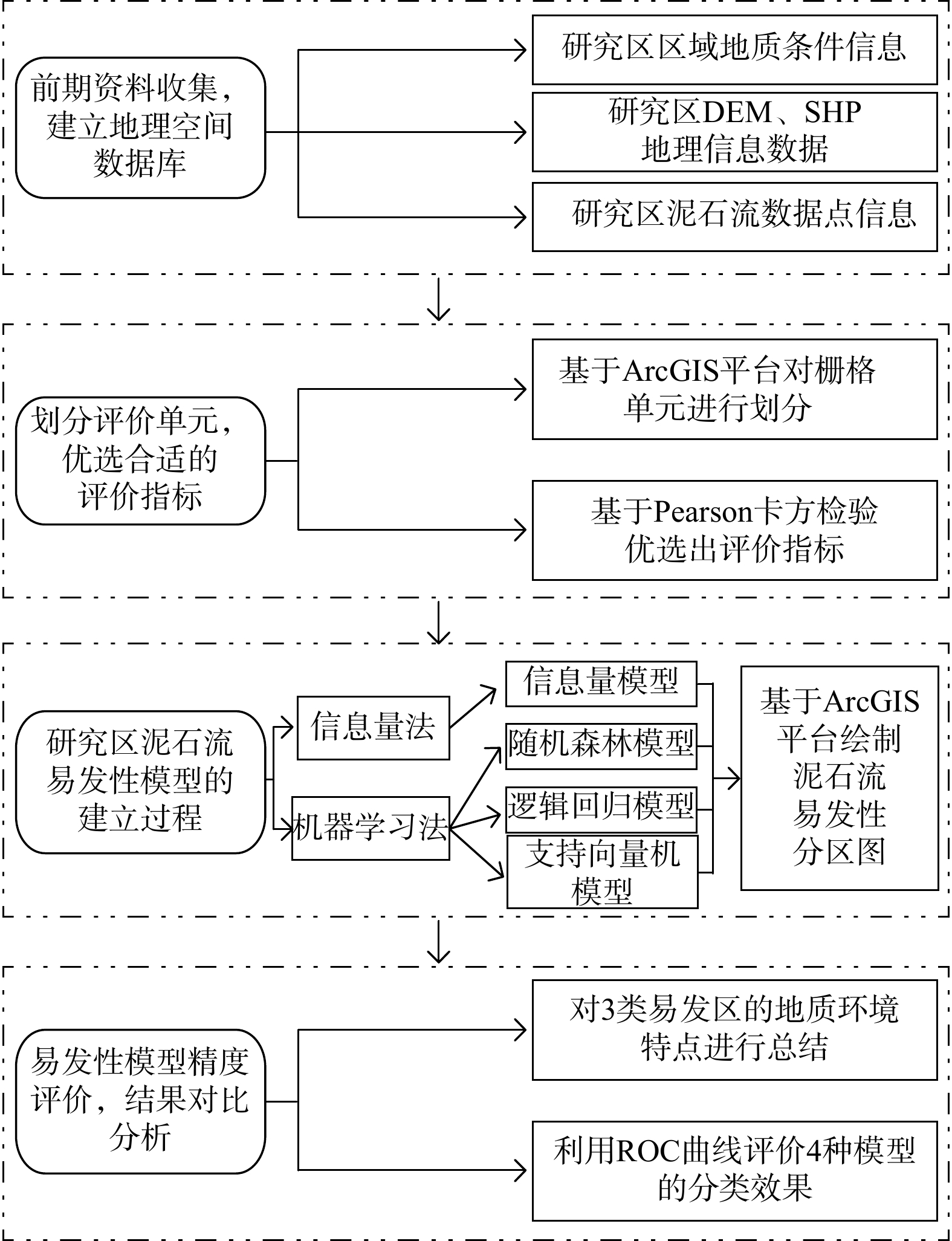
西藏地区地貌单元复杂、地质构造活跃,为该地区泥石流提供了良好的孕育环境,也对人类生命财产构成了极大威胁,开展泥石流易发性评价可为地区防灾减灾明确重点区域。以西藏自治区波密县−墨脱县为研究区域,利用Pearson卡方检验算法优选出高程、坡度、地层岩性、降雨量等12个对泥石流影响较高的因素作为评价指标,以研究区282个泥石流点和非泥石流点为样本数据库,基于ArcGIS平台利用信息量法和机器学习方法建立了4种易发性评价模型,并引入接受者操作特性(ROC)曲线和
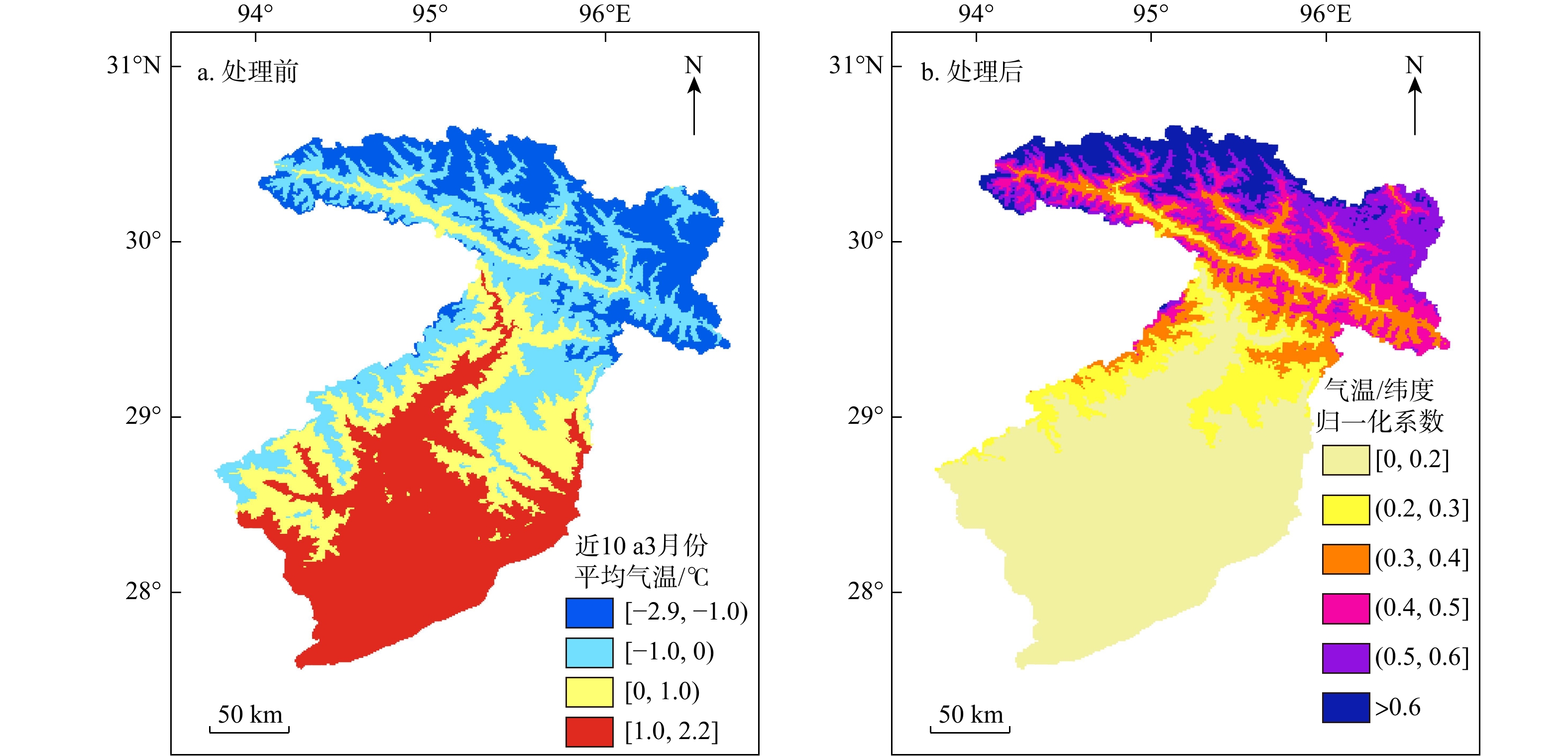
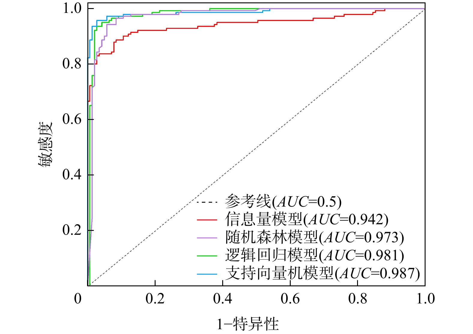
AUC (ROC曲线下方的积分面积)指标对泥石流易发性精度进行评估,得到了该地区的泥石流易发性评价分区。研究表明:(1)考虑不同维度泥石流类型主控因素不同,采用纬度和气温相融合的归一化系数作为泥石流易发性评价指标,在一定程度上消除了低海拔地区泥石流对温度的过度响应。(2)气温、距水系距离、距道路距离、地层岩性、高程是研究区泥石流发生的主控因素;植被覆盖率、地形湿度、坡度等因素也发挥着重要作用。(3)考虑泥石流灾害点和影响因子分级属性关系,对影响因子各分级属性赋分,作为输入特征进行训练,机器学习模型预测效果较好,平均AUC 值为0.980,整体优于传统的信息量模型。(4)SVM模型的AUC 值高达0.987,高易发区频率比率(FR )值为41.13且预测面积占比最小,具有在大尺度区域内进行高精度预测的能力。Abstract:Complex geomorphic units and active geological structures provide favorable conditions for debris flow in Tibet, which poses a great threats to human life and property.
ObjectiveThe evaluation of debris flow susceptibility can identify key areas for disaster reduction and prevention in this region.
MethodsTaking Bomi and Motuo Counties of Tibet Autonomous Region as the study area, 12 factors with high influence on debris flow, including elevation, slope, stratigraphic lithology and rainfall, were selected by Pearson Chi-square test algorithm as evaluation indexes. Data collected from 282 sits with and without debris flows in the study area were taken as the sample database. Based on ArcGIS platform, four susceptibility evaluation models were established by using Information Value Method and Machine Learning Method. The ROC curve and AUC index were introduced to evaluate the accuracy of debris flow susceptibility obtained from the proposed methods.
ResultsA debris flow susceptibility map for the study area was obtained.
ConclusionThe results indicate that: (1) Considering different types of debris flows in different dimensions and controlling factors, the normalization coefficients of latitude and temperature are used as the evaluation index of debris flow susceptibility, which can eliminate the excessive responses of debris flow to temperature in low altitude areas to a certain extent. (2) Air temperature, distance from water system, distance from road, formation lithology and elevation are the main factors of debris flow occurrence in the study area; Factors such as vegetation coverage, terrain humidity, and slope also play an important role. (3) Considering the relationship between the disaster points of debris flows and the classification attributes of the impact factors, the classification attributes of the impact factors are assigned scores and trained as input features. The machine learning model performs well, and its average
AUC is 0.980, which was better than the traditional information models. (4) TheAUC of SVM model is as high as 0.987, and theFR value of the highly prone region is 41.13. The prediction area of high-risk regions takes up the smallest proportion, demonstrating superior high-precision prediction capability in large-scale regions. -
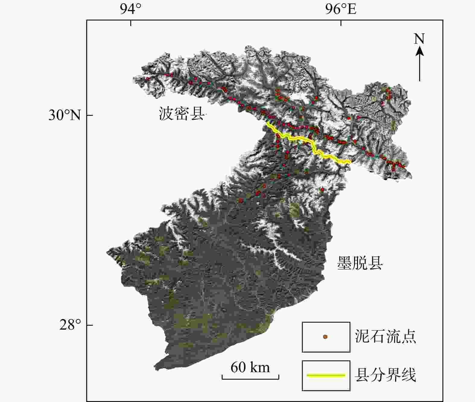
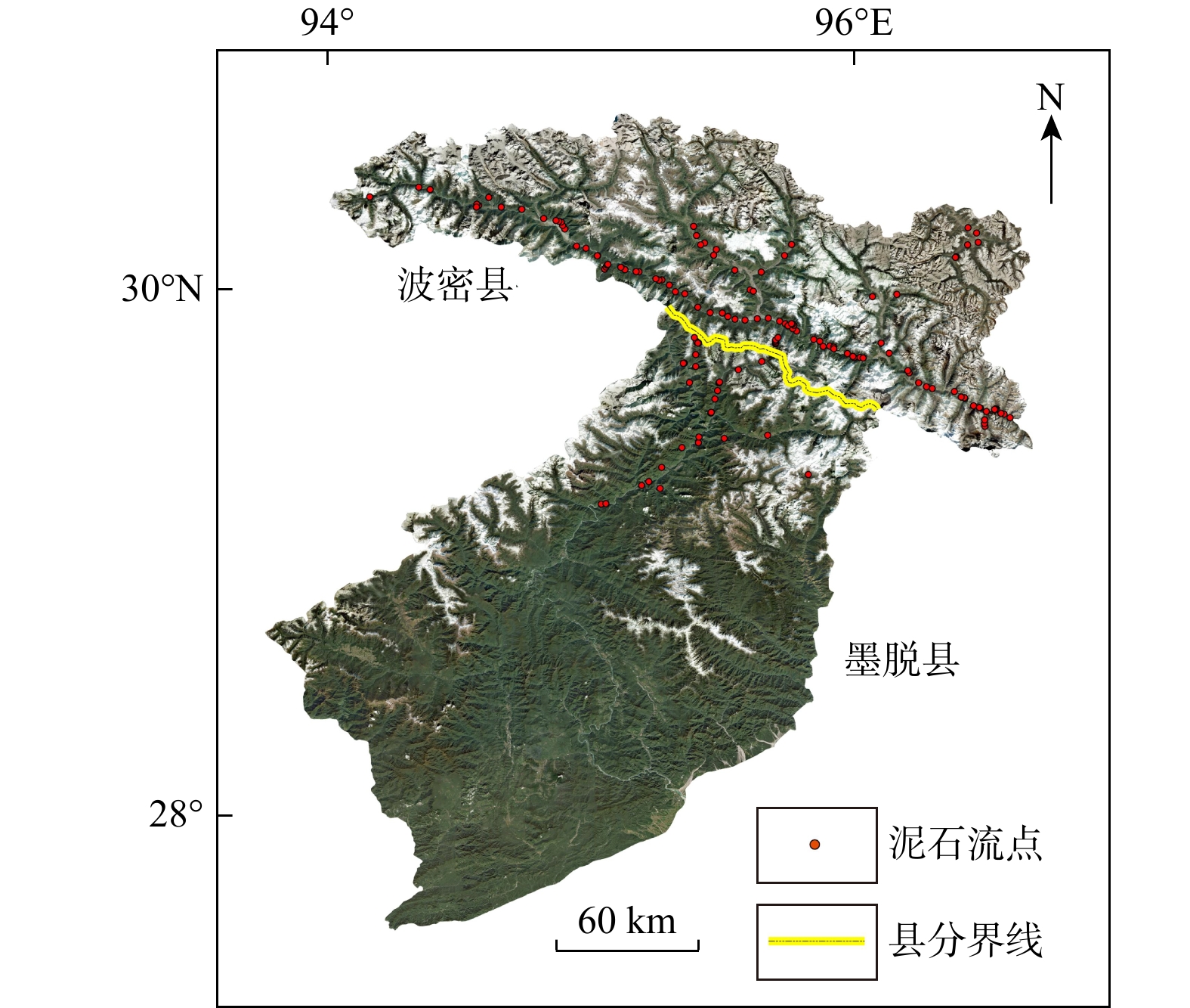
图 2 研究区范围及泥石流灾害点分布示意图
Figure 2. Scope of the study area and distribution of debris flow disaster points

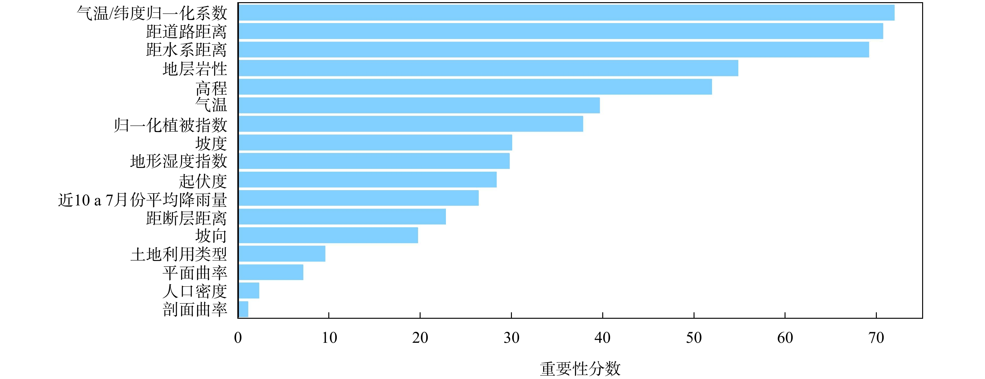
图 5 基于Pearson卡方检验算法的泥石流影响因子重要性排序
Figure 5. Importance ranking of debris flow impact factors based on Pearson Chi-square test algorithm

图 8 不同泥石流易发性模型下的ROC 曲线
Figure 8. ROC curves under different debris flow susceptibility models
表 1 数据类型及来源
Table 1. Data types and source
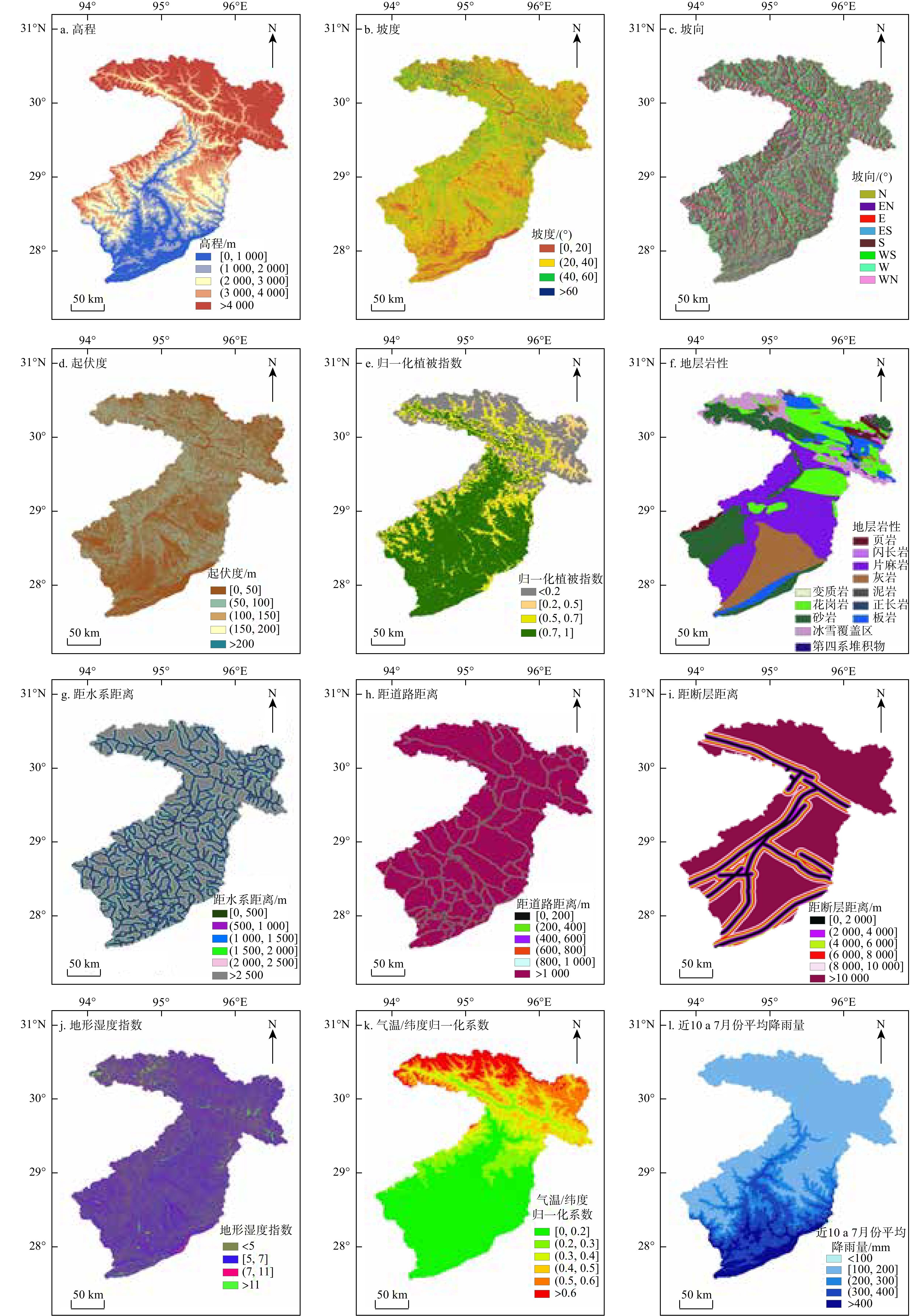
泥石流影响因子 数据获取 数据来源 泥石流点 西藏自治区地质灾害分布数据 地理遥感生态网(http://www.gisrs.cn/) 高程、坡度、坡向、曲率、起伏度、地形湿度指数 西藏自治区30 m精度DEM数字高程数据 地理空间数据云(https://www.gscloud.cn/) 土地利用类型 林芝市30 m精度土地覆盖数据 资源环境科学与数据中心(https://www.resdc.cn/) 气温、降雨量 林芝市2011—2020年气象数据集 国家青藏高原科学数据中心(https://data.tpdc.ac.cn/home) 地层岩性 西藏自治区地层岩性数据 地质云(https://geocloud.cgs.gov.cn/) 距道路距离、距水系距离 西藏自治区1∶100万公众版地形数据 全国地理信息资源目录服务系统(https://www.webmap.cn) 距断层距离 西藏自治区断层数据 中国地震局 人口密度 西藏自治区1 km人口分布栅格数据集 LandScan全球人口动态数据(https://landscan.ornl.gov/) 归一化植被指数 林芝市MOD13A3数据集 美国国家航空航天局(https://search.earthdata.nasa.gov/search)  下载: 导出CSV
表 2 各指标因素信息量值与分级得分汇总
Table 2. Information value and graded scores of each indicator factor
指标因素 分级 信息量值 分级得分 指标因素 分级 信息量值 分级得分 高程/m [0, 1000 )−1.212 1 坡度/(°) [0,20] 0.854 4 ( 1000 ,2000 ]−0.483 2 (20,40] −0.593 2 (2000, 3000 ]1.015 4 (40,60] −1.485 1 ( 3000 ,4000 ]0.485 3 >60 0.766 4 > 4000 −2.656 1 地层岩性 页岩 0.000 1 坡向/(°) N[0,22.5),[337.5,360) −0.520 1 闪长岩 0.183 1 EN[22.5,67.5) 0.021 2 花岗岩 0.850 1 E[67.5,112.5) −0.151 1 第四系堆积物 2.596 4 ES[112.5,157.5) −0.069 2 砂岩 0.043 1 S[157.5,202.5) 0.262 3 片麻岩 −0.442 2 WS[202.5,247.5) 0.647 4 灰岩 0.000 1 W[247.5,292.5) −0.458 1 泥岩 1.160 3 WN[292.5,337.5) −0.433 1 正长岩 0.000 1 起伏度/m [0,50] 0.298 3 板岩 0.425 1 (50,100] −0.966 1 变质岩 0.000 1 (100,150] −1.356 1 冰雪覆盖区 −1.560 1 (150,200] 0.000 1 气温/纬度归一化系数 [0,0.2] −1.217 2 >200 1.253 4 (0.2,0.3] 1.294 4 近10 a 7月份平均
降雨量/mm<100 0.000 3 (0.3,0.4] 1.253 4 [100,200] 0.334 4 (0.4,0.5] −0.395 3 (200,300] −0.471 2 (0.5,0.6] 0.000 1 (300,400] −1.660 1 >0.6 0.000 1 >400 0.000 1 地形湿度指数 <5 −0.905 1 距水系距离/m [0,500] 1.532 4 [5,7] −0.332 1 (500, 1000 ]0.300 3 (7,11] 0.436 2 ( 1000 ,1500 ]−0.628 2 >11 2.109 4 ( 1500 ,2000 ]−1.742 1 归一化植被指数 <0.2 0.000 1 ( 2000 ,2500 ]−2.717 1 [0.2~0.5] 0.928 3 > 2500 0.000 1 (0.5~0.7] 1.048 4 距断层距离/m [0, 2000 ]0.915 4 (0.7,1] −0.702 1 ( 2000 ,4000 ]0.100 2 距道路距离/m [0,200] 2.810 4 ( 4000 ,6000 ]−0.117 1 (200,400] 1.553 4 ( 6000 ,8000 ]−0.355 1 (400,600] 0.357 2 ( 8000 ,10000 ]−0.379 1 (600,800] 0.716 3 > 10000 −0.191 1 (800, 1000 ]−0.653 1 > 1000 −1.567 1
下载: 导出CSV
表 3 不同模型下泥石流易发等级面积占比及频率比值统计结果
Table 3. Statistical results of area proportion and frequency ratio of debris flow prone grade under different models
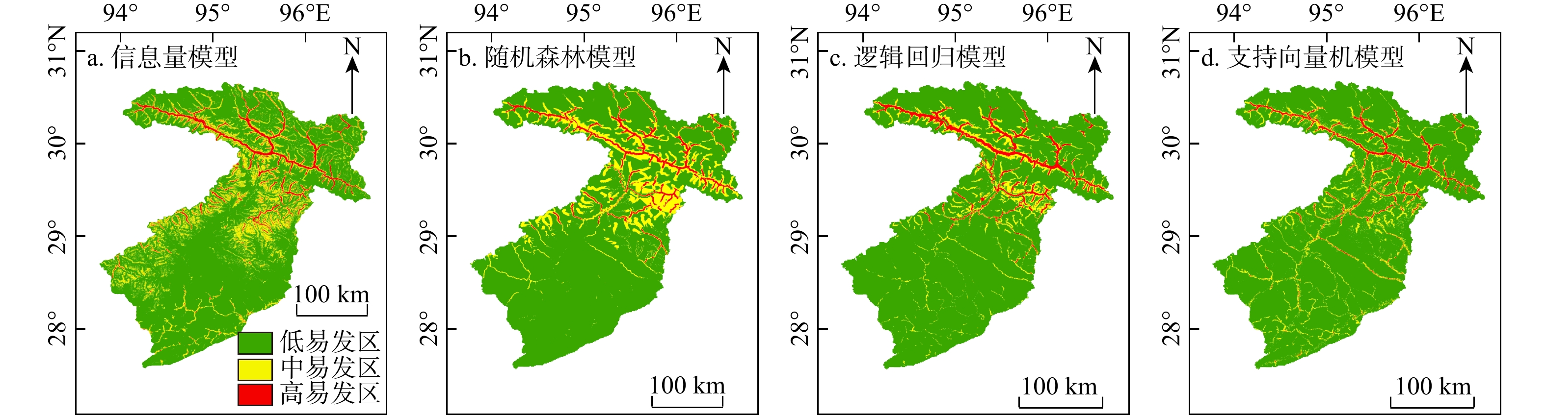
统计类型 模型方法 易发性等级 低 中 高 面积占比/% 信息量(IM) 77 18 5 随机森林(RF) 82 15 3 逻辑回归(LR) 87 9 4 支持向量机(SVM) 89 9 2 频率比值(FR) 信息量(IM) 0.10 0.91 15.18 随机森林(RF) 0.04 1.13 26.48 逻辑回归(LR) 0.05 1.65 20.21 支持向量机(SVM) 0.07 1.26 41.13
下载: 导出CSV
-
[1] MY E A. Debris flow susceptibility mapping in a portion of the Andes and Preandes of San Juan,Argentina using frequency ratio and logistic regression models[J]. Earth Science Research Journal,2013,17(2):159-167. [2] BRABB E E,PAMPEYAN E H,BONILLA M G. Landslide susceptibility in San Mateo County,California[J]. Miscellaneous Field Studies Map,1972. [3] 谭炳炎. 泥石流沟严重程度的数量化综合评判[J]. 铁道学报,1986,8(2):74-82. doi: 10.3321/j.issn:1001-8360.1986.02.008TAN B Y. Quantified comprehensive evaluation for the scope and intensity of mud-rock flow gully activity[J]. Journal of the China Railway Society,1986,8(2):74-82. (in Chinese with English abstract doi: 10.3321/j.issn:1001-8360.1986.02.008 [4] XU W B,YU W J,JING S C,et al. Debris flow susceptibility assessment by GIS and information value model in a large-scale region,Sichuan Province (China)[J]. Natural Hazards,2013,65(3):1379-1392. doi: 10.1007/s11069-012-0414-z [5] XIONG K,ADHIKARI B R,STAMATOPOULOS C A,et al. Comparison of different machine learning methods for debris flow susceptibility mapping:A case study in the Sichuan Province,China[J]. Remote Sensing,2020,12(2):295. doi: 10.3390/rs12020295 [6] ZHU Z F,GAN S,YUAN X P,et al. Landslide susceptibility mapping with integrated SBAS-InSAR technique:A case study of Dongchuan district,Yunnan (China)[J]. Sensors,2022,22(15):5587. doi: 10.3390/s22155587 [7] WU S E,CHEN J,ZHOU W,et al. A modified logit model for assessment and validation of debris-flow susceptibility[J]. Bulletin of Engineering Geology and the Environment,2019,78(6):4421-4438. doi: 10.1007/s10064-018-1412-5 [8] 刘永垚,第宝锋,詹宇,等. 基于随机森林模型的泥石流易发性评价:以汶川地震重灾区为例[J]. 山地学报,2018,36(5):765-773.LIU Y Y,DI B F,ZHAN Y,et al. Debris flows susceptibility assessment in Wenchuan earthquake areas based on random forest algorithm model[J]. Mountain Research,2018,36(5):765-773. (in Chinese with English abstract [9] 温鑫,范宣梅,陈兰,等. 基于信息量模型的地质灾害易发性评价:以川东南古蔺县为例[J]. 地质科技通报,2022,41(2):290-299.WEN X,FAN X M,CHEN L,et al. Susceptibility assessment of geological disasters based on an information value model:A case of Gulin County in Southeast Sichuan[J]. Bulletin of Geological Science and Technology,2022,41(2):290-299. (in Chinese with English abstract [10] 吴雅睿,娄春辉,侯龙君,等. 基于信息量与机器学习耦合模型的滑坡易发性评价对比分析[J]. 西安科技大学学报,2024,44(6):1140-1153.WU Y R,LOU C H,HOU L J,et al. Comparative analysis of landslide susceptibility evaluation based on the coupling model of information quantity and machine learning[J]. Journal of Xi'an University of Science and Technology,2024,44(6):1140-1153. (in Chinese with English abstract [11] MYRONIDIS D,PAPAGEORGIOU C,THEOPHANOUS S. Landslide susceptibility mapping based on landslide history and analytic hierarchy process (AHP)[J]. Natural Hazards,2016,81(1):245-263. doi: 10.1007/s11069-015-2075-1 [12] YANG Z Q,ZHU Y Y,STEVE ZOU D H,et al. Activity degree evaluation of glacial debris flow along international Karakorum highway (KKH) based on fuzzy theory[J]. Advanced Materials Research,2011,261/262/263:1167-1171. [13] 胡凯衡,崔鹏,韩用顺,等. 基于聚类和最大似然法的汶川灾区泥石流滑坡易发性评价[J]. 中国水土保持科学,2012,10(1):12-18. doi: 10.3969/j.issn.1672-3007.2012.01.003HU K H,CUI P,HAN Y S,et al. Susceptibility mapping of landslides and debris flows in 2008 Wenchuan earthquake by using cluster analysis and maximum likelihood classification methods[J]. Science of Soil and Water Conservation,2012,10(1):12-18. (in Chinese with English abstract doi: 10.3969/j.issn.1672-3007.2012.01.003 [14] LEE S,MIN K. Statistical analysis of landslide susceptibility at Yongin,Korea[J]. Environmental Geology,2001,40(9):1095-1113. doi: 10.1007/s002540100310 [15] CHEN W,POURGHASEMI H R,KORNEJADY A,et al. Landslide spatial modeling:Introducing new ensembles of ANN,MaxEnt,and SVM machine learning techniques[J]. Geoderma,2017,305:314-327. doi: 10.1016/j.geoderma.2017.06.020 [16] 邬礼扬,殷坤龙,曾韬睿,等. 不同栅格尺寸下输电线路地质灾害易发性评价[J]. 地质科技通报,2024,43(1):241-252.WU L Y,YIN K L,ZENG T R,et al. Evaluation of geological disaster susceptibility of transmission lines under different grid resolutions[J]. Bulletin of Geological Science and Technology,2024,43(1):241-252. (in Chinese with English abstract [17] 郑德凤,潘美伊,高敏,等. 集中降雨影响下辽南仙人洞国家级自然保护区滑坡灾害多因子风险评价[J]. 地质科技通报,2025,44(2):48-58 .ZHENG D F,PAN M Y,GAO M,et al. Multi-factor risk assessment of landslide disasters under concentrated rainfall in Xianrendong National Nature Reserve in southern Liaoning Province[J]. Bulletin of Geological Science and Technology,2025,44(2):48-58. (in Chinese with English abstract [18] 陈航,刘惠军,王韬,等. 基于频率比−深度神经网络耦合模型的滑坡易发性评价:以盐源县为例[J]. 水文地质工程地质,2024,51(5):161-171.CHEN H,LIU H J,WANG T,et al. Landslide susceptibility evaluation based on FR-DNN coupling model:A case study on Yanyuan County[J]. Hydrogeology & Engineering Geology,2024,51(5):161-171. (in Chinese with English abstract [19] 邓日朗,张庆华,刘伟,等. 基于改进两步法采样策略和卷积神经网络的崩塌易发性评价[J]. 地质科技通报,2024,43(2):186-200.DENG R L,ZHANG Q H,LIU W,et al. Collapse susceptibility evaluation based on an improved two-step sampling strategy and a convolutional neural network[J]. Bulletin of Geological Science and Technology,2024,43(2):186-200. (in Chinese with English abstract [20] 王昌明,黄健,李桥,等. 基于信息量模型与Logistic回归模型耦合的山西吕梁市地质灾害易发性评价研究[J]. 水利水电技术,2019,50(3):132-138.WANG C M,HUANG J,LI Q,et al. Evaluation of geological hazard vulnerability in Lyuliang City in Shanxi Province based on coupling of information content model and Logistic regression model[J]. Water Resources and Hydropower Engineering,2019,50(3):132-138. (in Chinese with English abstract [21] 陈朝亮,彭树宏,钱静,等. 基于AHP-Logistic熵权模型的西南浅丘区地质灾害分布特征研究:以内江市为例[J]. 长江科学院院报,2020,37(2):55-61. doi: 10.11988/ckyyb.20181136CHEN C L,PENG S H,QIAN J,et al. Distribution characteristics of geological hazards in southwestern shallow hill based on AHP-Logistic entropy combined weight model:A case study of Neijiang City[J]. Journal of Yangtze River Scientific Research Institute,2020,37(2):55-61. (in Chinese with English abstract doi: 10.11988/ckyyb.20181136 [22] TIEN BUI D,TUAN T A,KLEMPE H,et al. Spatial prediction models for shallow landslide hazards:A comparative assessment of the efficacy of support vector machines,artificial neural networks,kernel logistic regression,and logistic model tree[J]. Landslides,2016,13(2):361-378. doi: 10.1007/s10346-015-0557-6 [23] 张瀛. 波密至扎木110 kV输电线路工程沿线泥石流灾害分析与防治[D]. 兰州:兰州大学,2021.ZHANG Y. Analysis and prevention of debris flow disaster along the 110 kV power line from Bomi to Zhamu[D]. Lanzhou:Lanzhou University,2021. (in Chinese with English abstract [24] 陈礼然. 波密杂岩锆石U-Pb年代学、地球化学和Hf同位素组成对拉萨地体前寒武纪演化的约束[D]. 武汉:中国地质大学(武汉),2019.CHEN L R. Constraints of zircon U-Pb chronology,geochemistry and Hf isotopic composition of Bomi complex on Precambrian evolution of Lhasa terrane[D]. Wuhan:China University of Geosciences (Wuhan),2019. (in Chinese with English abstract [25] 田海. 西藏波密地区冰川泥石流的成因机制分析[D]. 成都:成都理工大学,2018.TIAN H. Formation mechanism of glacial debris flow in Bomi,Tibet[D]. Chengdu:Chengdu University of Technology,2018. (in Chinese with English abstract [26] 李翔. 雅鲁藏布江墨脱河段大型滑坡发育与新构造地貌演化关联性研究[D]. 成都:成都理工大学,2019.LI X. Study on the correlation between the development of large landslide and the evolution of neotectonic geomorphology in Medog reach of Yarlung Zangbo River[D]. Chengdu:Chengdu University of Technology,2019. (in Chinese with English abstract [27] PHAM B T,VAN DAO D,ACHARYA T D,et al. Performance assessment of artificial neural network using Chi-square and backward elimination feature selection methods for landslide susceptibility analysis[J]. Environmental Earth Sciences,2021,80(20):686. doi: 10.1007/s12665-021-09998-5 [28] 陈前,晏鄂川,黄少平,等. 基于样本与因子优化的黄冈南部地区地质灾害易发性评价[J]. 地质科技通报,2020,39(2):175-185.CHEN Q,YAN E C,HUANG S P,et al. Susceptibility evaluation of geological disasters in southern Huanggang based on samples and factor optimization[J]. Bulletin of Geological Science and Technology,2020,39(2):175-185. (in Chinese with English abstract [29] LING X,ZHU Y Q,MING D P,et al. Feature engineering of geohazard susceptibility analysis based on the random forest algorithm:Taking Tianshui City,Gansu Province,as an example[J]. Remote Sensing,2022,14(22):5658. [30] WANG H S,XU J,TAN S C,et al. Landslide susceptibility evaluation based on a coupled informative-logistic regression model:Shuangbai County as an example[J]. Sustainability,2023,15(16):12449. doi: 10.3390/su151612449 [31] QIN S W,QIAO S S,YAO J Y,et al. Establishing a GIS-based evaluation method considering spatial heterogeneity for debris flow susceptibility mapping at the regional scale[J]. Natural Hazards,2022,114(3):2709-2738. doi: 10.1007/s11069-022-05487-5 [32] STANCANELLI L M,PERES D J,CANCELLIERE A,et al. A combined triggering-propagation modeling approach for the assessment of rainfall induced debris flow susceptibility[J]. Journal of Hydrology,2017,550:130-143. doi: 10.1016/j.jhydrol.2017.04.038 [33] 邹强,唐建喜,李淑松,等. 基于水文响应单元的泥石流灾害易发性分区方法[J]. 山地学报,2017,35(4):496-505.ZOU Q,TANG J X,LI S S,et al. Susceptibility assessment method of debris flows based on hydrological response unit[J]. Mountain Research,2017,35(4):496-505. (in Chinese with English abstract [34] 王向前,丁明涛,何雨枫. 基于RF模型的甘孜藏族自治州乡城县泥石流易发性评价[J]. 灾害学,2023,38(3):222-226. doi: 10.3969/j.issn.1000-811X.2023.03.034WANG X Q,DING M T,HE Y F. Assessment of debris flow vulnerability in Xiangcheng County,Ganzi Tibetan Autonomous Prefecture based on RF model[J]. Journal of Catastrophology,2023,38(3):222-226. (in Chinese with English abstract doi: 10.3969/j.issn.1000-811X.2023.03.034 [35] 张以晨,秦胜伍,翟健健,等. 基于信息量的长白山地区泥石流易发性评价[J]. 水文地质工程地质,2018,45(2):150-158.ZHANG Y C,QIN S W,ZHAI J J,et al. Susceptibility assessment of debris flow based on GIS and weight information for the Changbai Mountain area[J]. Hydrogeology & Engineering Geology,2018,45(2):150-158. (in Chinese with English abstract [36] 李益敏,李驭豪,赵志芳. 基于确定性系数模型的泸水市泥石流易发性评价[J]. 水土保持研究,2019,26(4):336-342.LI Y M,LI Y H,ZHAO Z F. Assessment on susceptibility of debris flow in Lushui based on the certain factor model[J]. Research of Soil and Water Conservation,2019,26(4):336-342. (in Chinese with English abstract [37] 饶姗姗,冷小鹏. 基于RSIV-RF模型的凉山州泥石流易发性评价[J]. 地质科技通报,2024,43(1):275-287.RAO S S,LENG X P. Debris flow susceptibility evaluation of Liangshan Prefecture based on the RSIV-RF model[J]. Bulletin of Geological Science and Technology,2024,43(1):275-287. (in Chinese with English abstract [38] CASCINI L. Applicability of landslide susceptibility and hazard zoning at different scales[J]. Engineering Geology,2008,102(3/4):164-177. [39] PRADHAN B,LEE S. Delineation of landslide hazard areas on Penang Island,Malaysia,by using frequency ratio,logistic regression,and artificial neural network models[J]. Environmental Earth Sciences,2010,60(5):1037-1054. doi: 10.1007/s12665-009-0245-8 [40] 李泽群. 基于BP人工神经网络和GIS的湖南省鼎城区滑坡易发性评价[D]. 石家庄:河北地质大学,2020.LI Z Q. Evaluation of landslide susceptibility based on BP artificial neural network and GIS in Dingcheng District[D]. Shijiazhuang:Hebei GEO University,2020. -

 下载:
下载:

 点击查看大图
计量
- 文章访问数: 923
- PDF下载量: 54
- 被引次数: 0

