
 投审稿入口
投审稿入口

-
摘要:
利用三维建模技术模拟地质体的三维形态,能够有效揭示地质体的空间分布特征。与隐式建模方法相比较,显式建模方法在小尺度的地质结构特征上刻画更加精准,然而对于形态复杂脉状矿体等地质体的大比例尺精细化三维建模,还存在建模速度慢、难度大、精度偏低等问题亟待解决。针对部分复杂脉状矿体,综合运用加密约束点、构建矿体劈分线、分段式建模、矿体缝合等技术,系统开展了分枝分岔复合矿体、存在无矿天窗矿体、含夹石矿体、断层切穿矿体4种复杂脉状矿体的显式三维建模方法研究,实现了复杂脉状矿体的高精度快速三维建模,对稀有、贵金属等复杂脉状矿体的精细化三维建模、矿产资源量估算、矿产资源开发利用方案制定等具有重要意义。
Abstract:ObjectiveThe simulation of three-dimensional morphology of geological bodies through 3D modeling technology can effectively reveal the spatial distribution characteristics of geological bodies. Compared with implicit modeling methods, explicit modeling methods can depict the small-scale geological structure features more accurately. However, for the large-scale and fine 3D modeling of complex geological bodies such as vein-type ore bodies with complex shapes, there are still problems such as slow modeling speed, high difficulty, and low accuracy that need to be solved.
MethodsThis study, focusing on some complex vein-type ore bodies, comprehensively applied techniques such as densified constraint points, construction of ore body splitting lines, segmented modeling, and ore body stitching, to systematically conduct research on the explicit 3D modeling methods of four types of vein-type ore bodies: branched and bifurcated composite ore bodies, ore bodies with barren windows, ore bodies with intercalated rocks, and ore bodies cut by faults.
Results and ConclusionIt achieved high-precision and rapid 3D modeling of complex vein-type ore bodies, which is of great significance for the fine 3D modeling of rare and precious metal vein-type ore bodies, estimation of mineral resources, and formulation of mineral resource development and utilization plans.
-

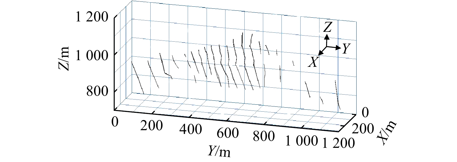
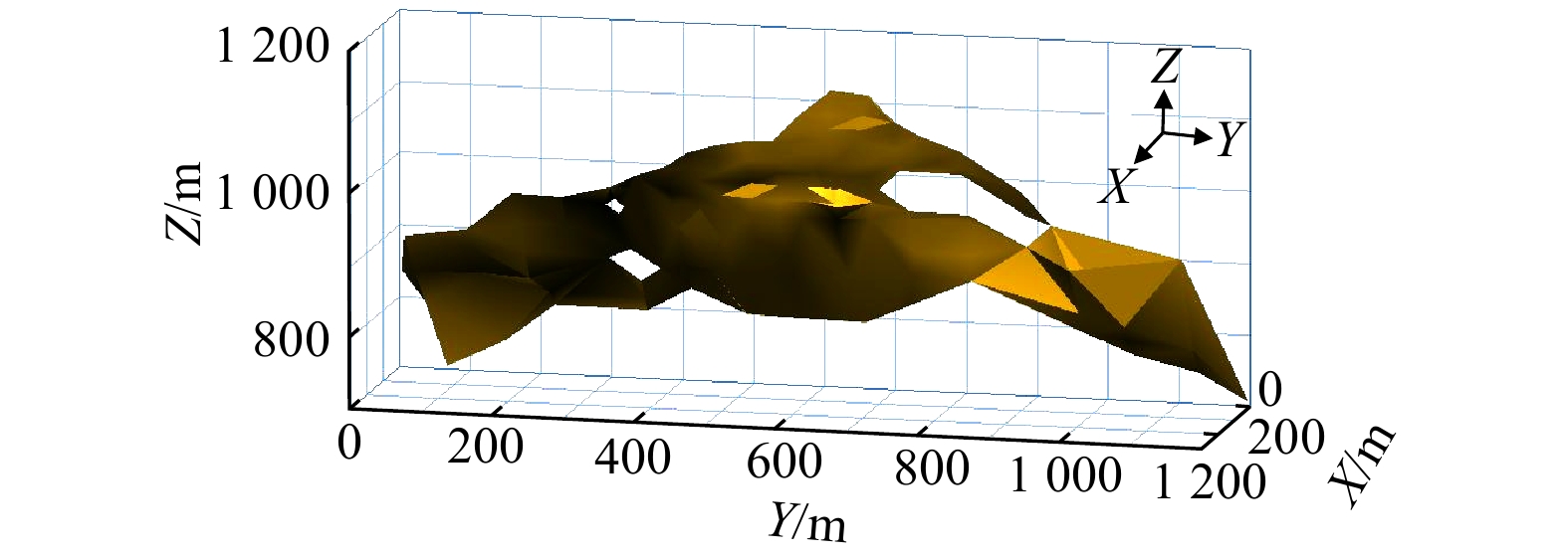
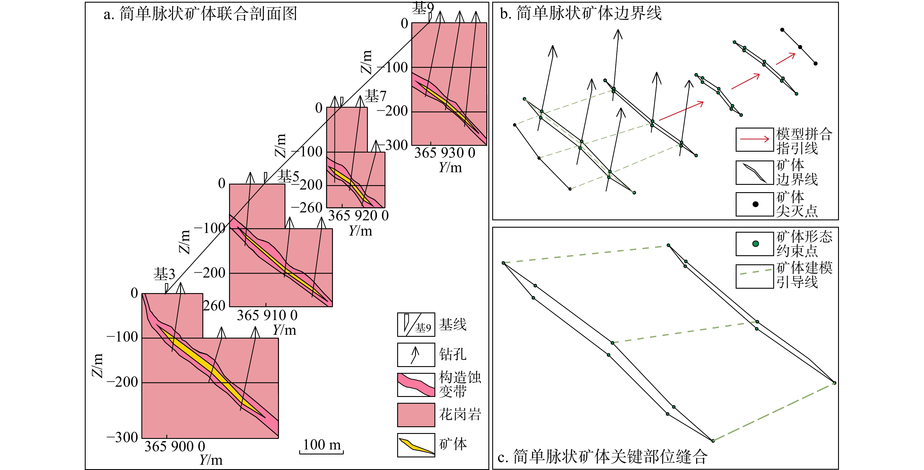
图 4 简单脉状矿体建模方法流程示意图
Figure 4. Modeling method flow diagram of simple vein-type ore bodies

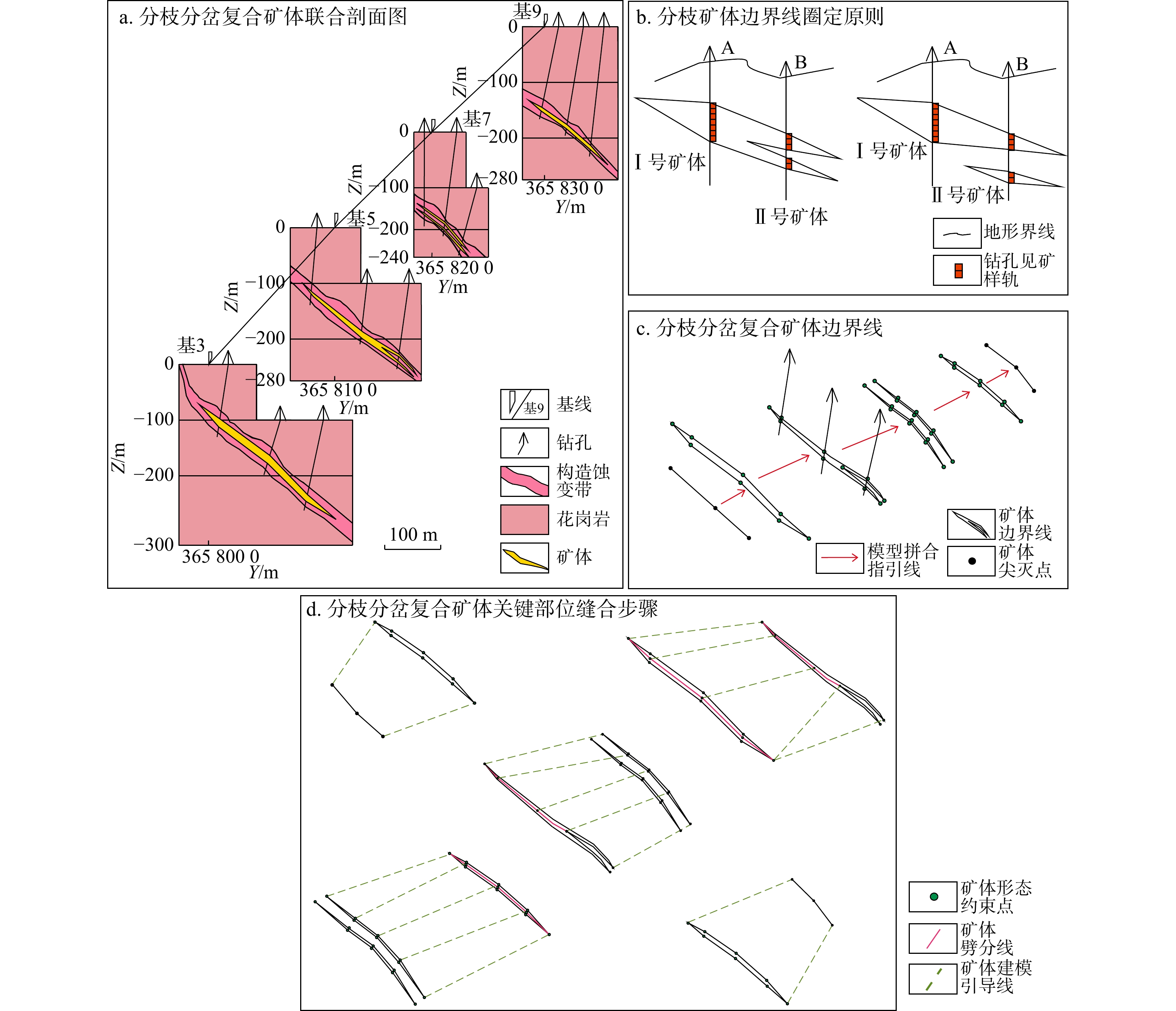
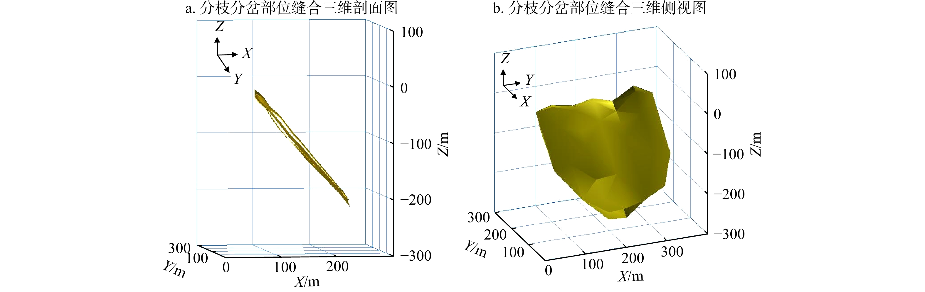
图 6 分枝分岔复合矿体建模方法流程示意图
Figure 6. Modeling method flow diagram of branched and bifurcated composite ore bodies

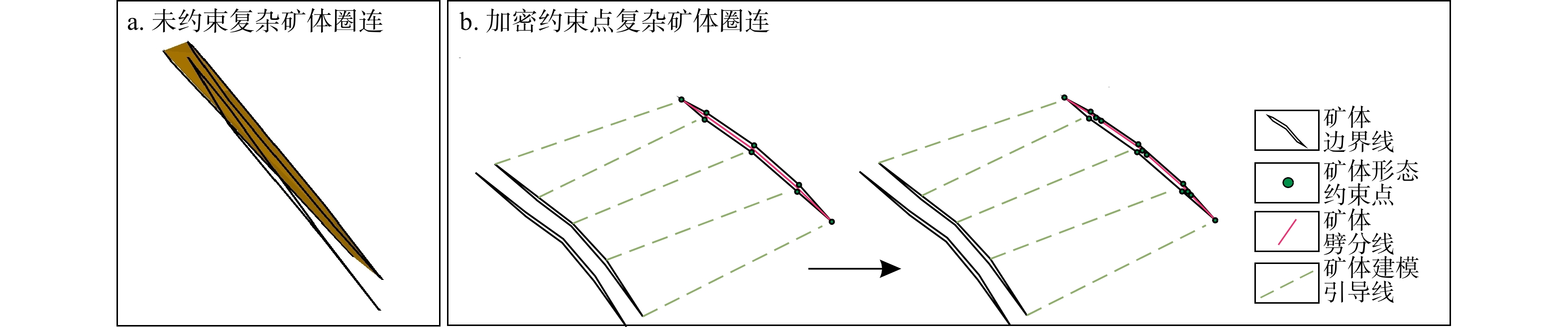
图 7 加密约束点构建关键复杂部位矿体形态
Figure 7. Constructing ore body morphology of key complex parts based on densified constraint points

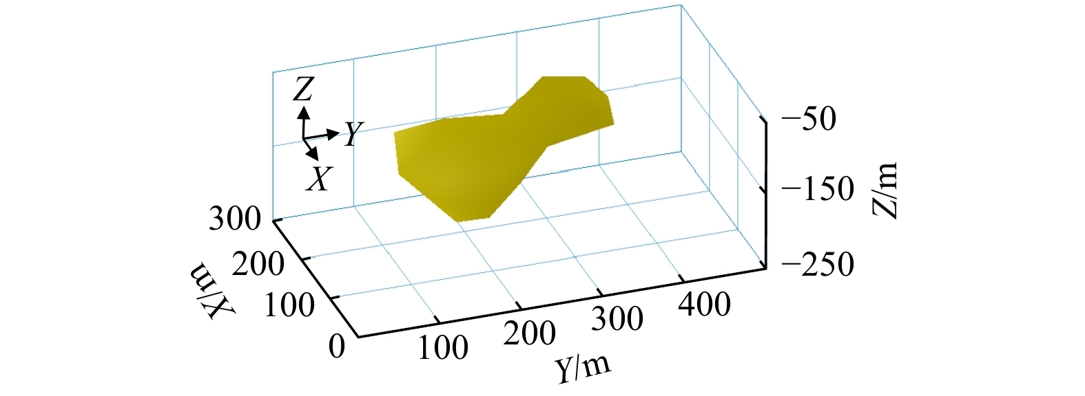
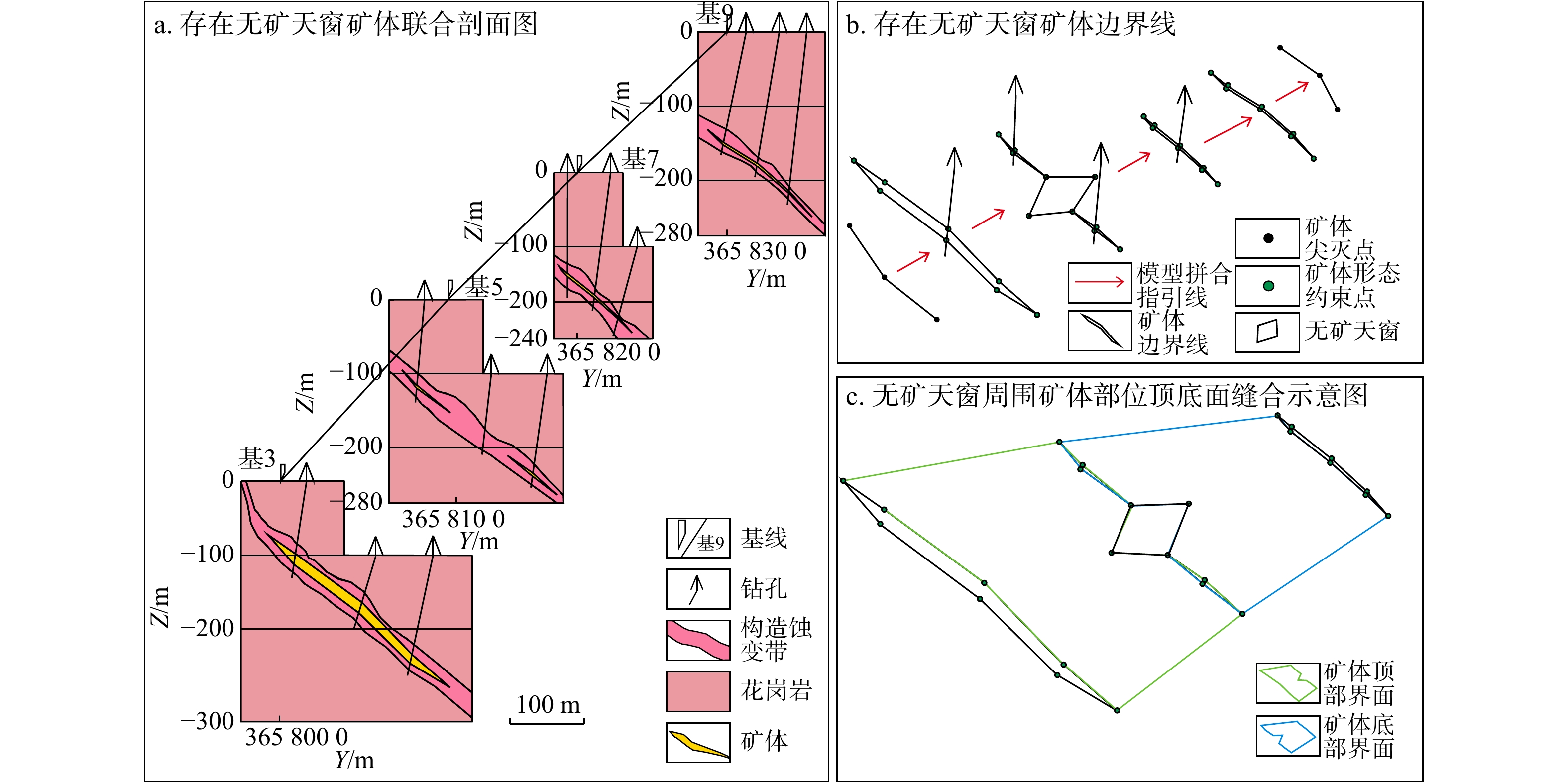
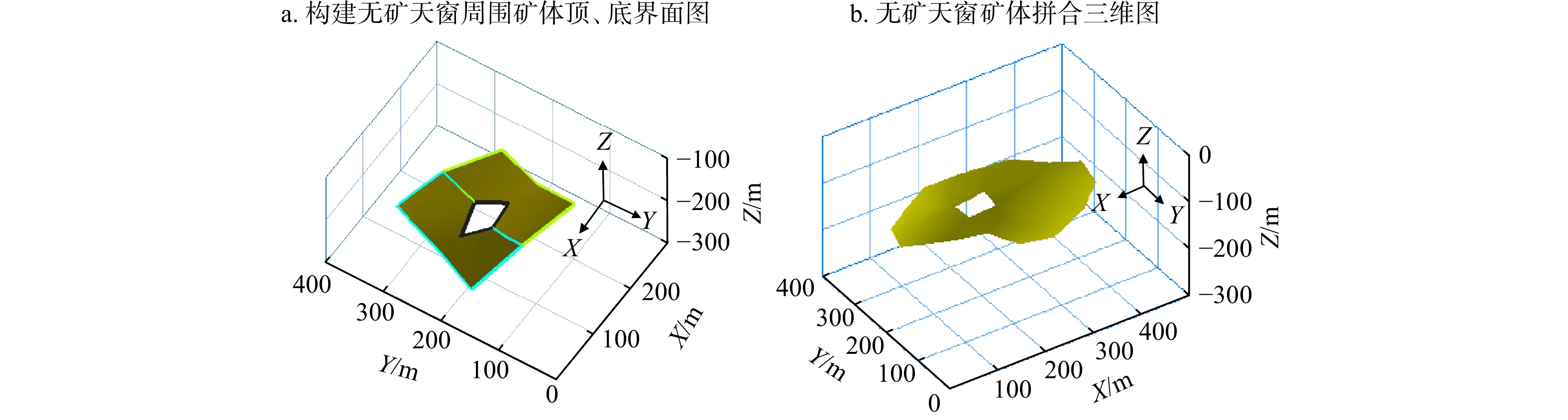
图 9 存在无矿天窗矿体建模方法流程示意图
Figure 9. Modeling method flow diagram of ore bodies with barren windows

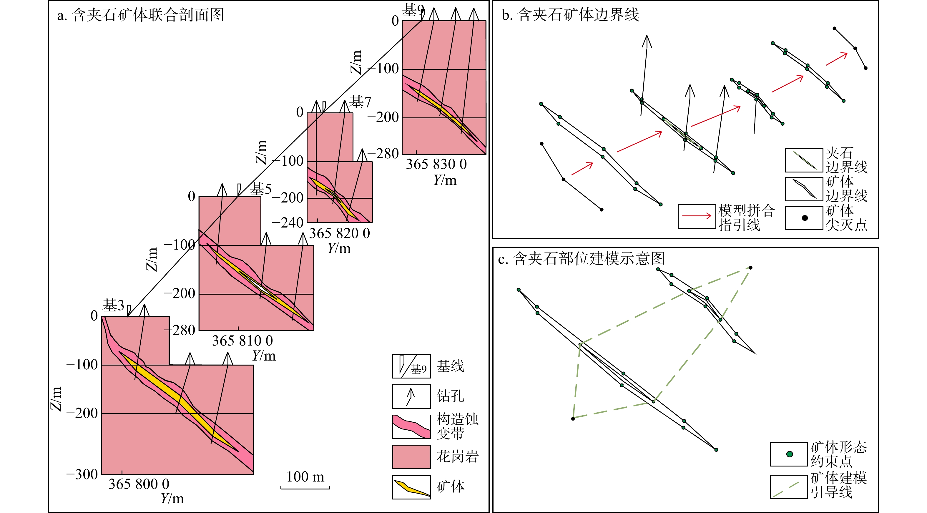
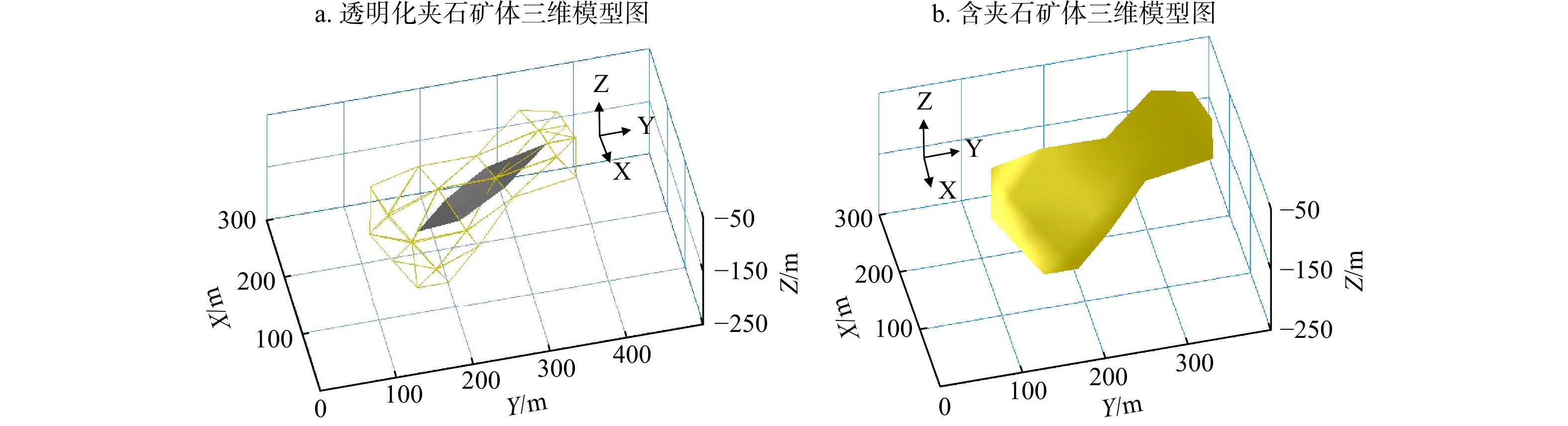
图 11 含夹石矿体建模方法流程示意图
Figure 11. Modeling method flow diagram of ore bodies with intercalated rocks

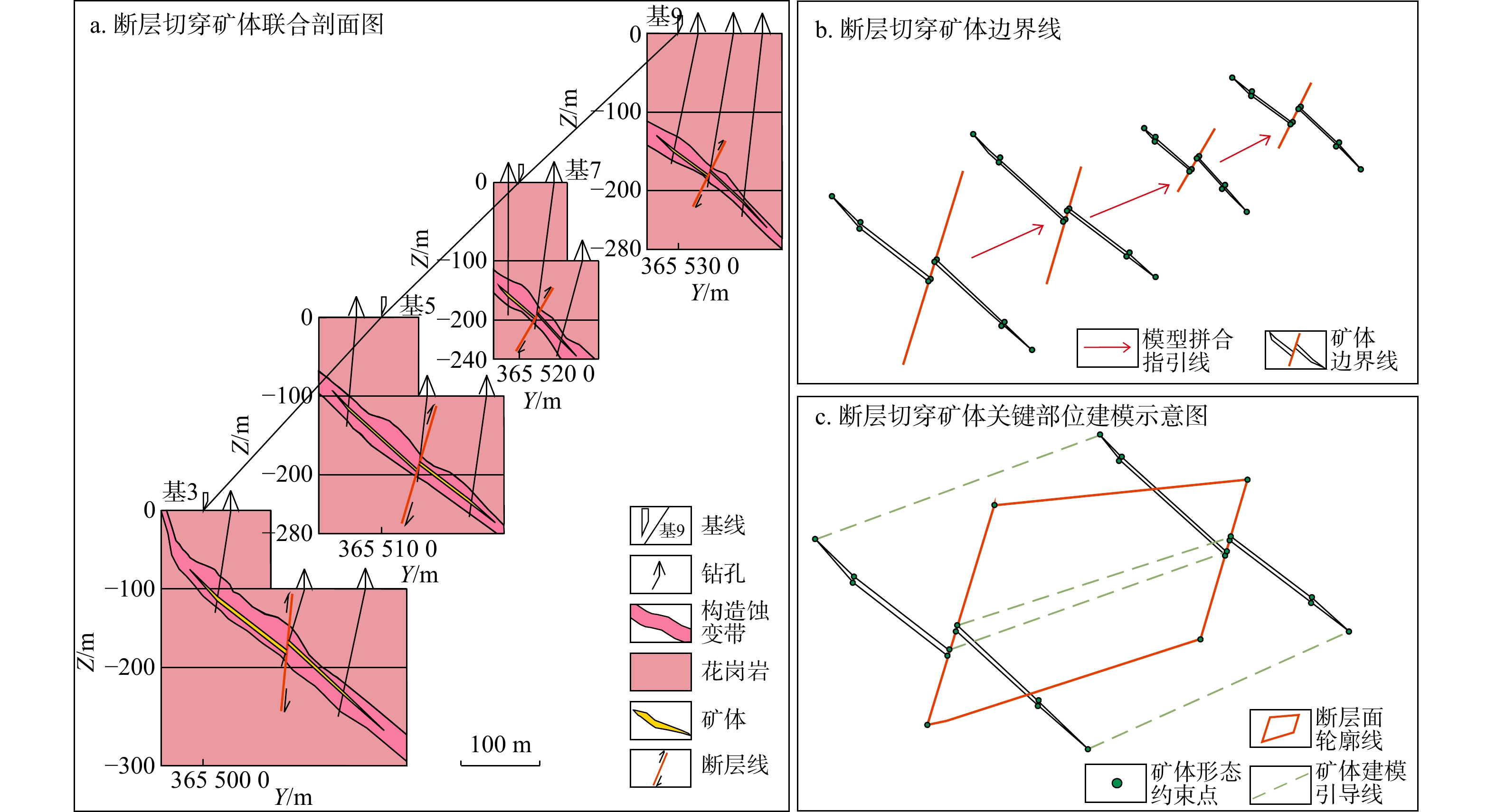
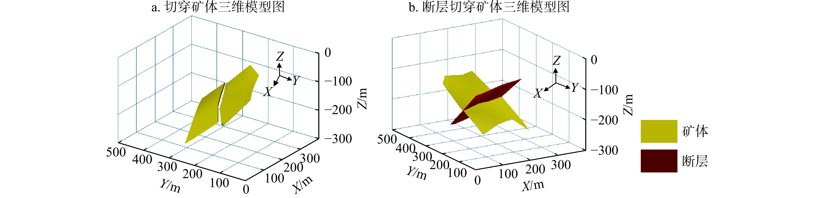
图 13 断层切穿矿体建模方法流程示意图
Figure 13. Modeling method flow diagram of ore bodies cut by faults

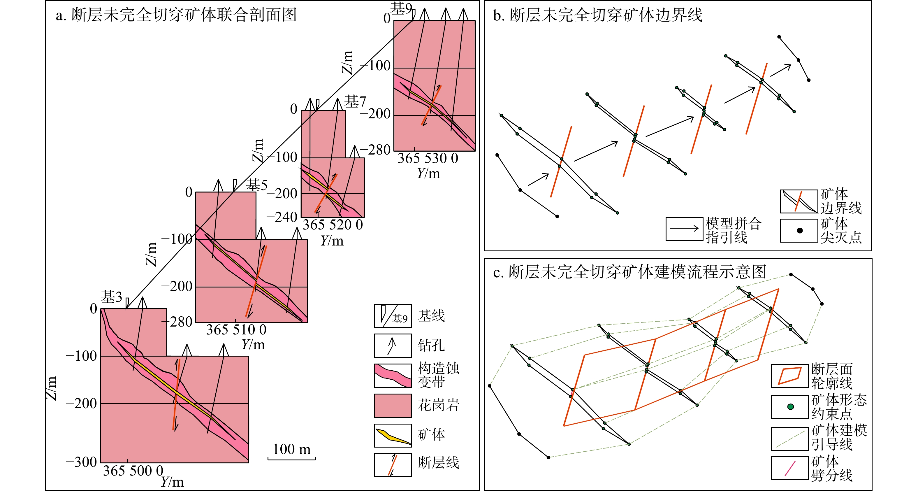
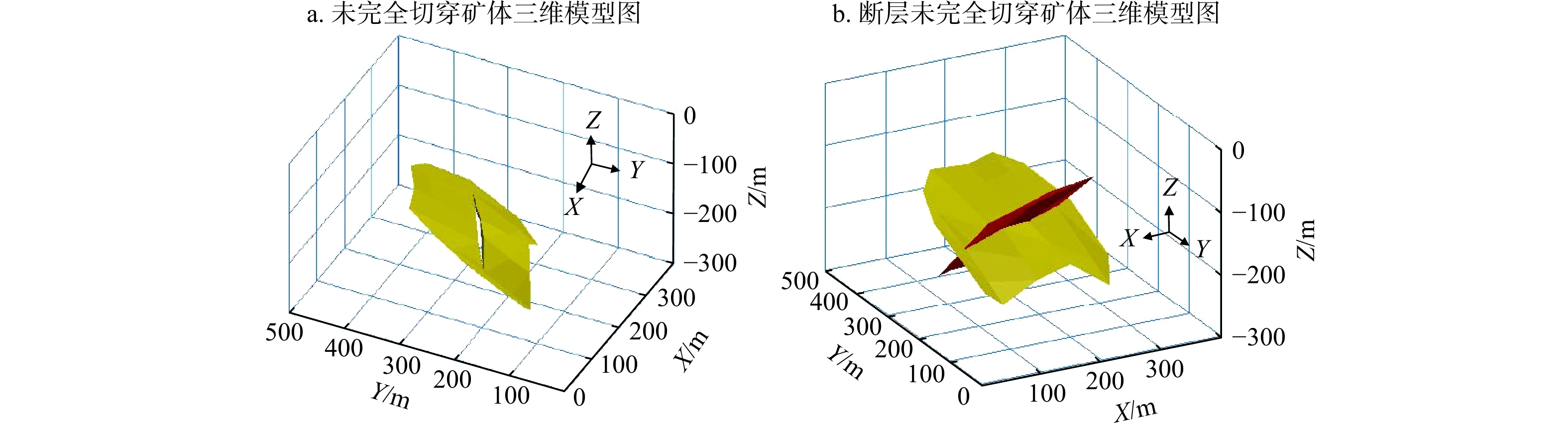
图 15 断层未完全切穿矿体建模方法流程示意图
Figure 15. Modeling method flow diagram of ore bodies with not cutting through fault
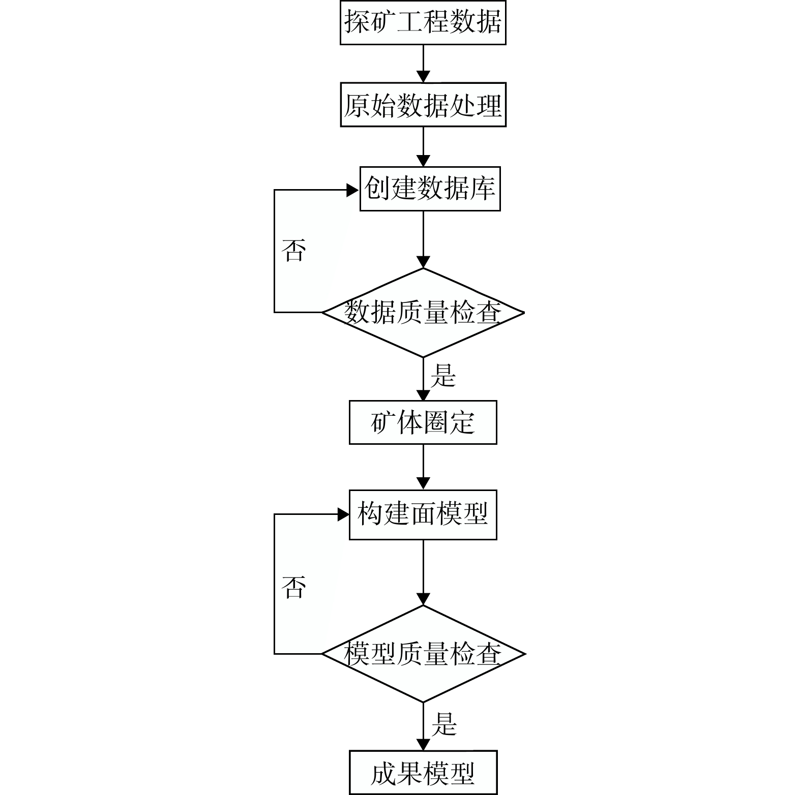
表 1 探矿工程数据结构表
Table 1. Data structure table of prospecting engineering
表格名称 表头名称 工程信息表
(COLLAR).CSV工程名称、工程坐标X-Y、高程、工程深度 工程测斜表
(SURVEY).CSV工程名称、测斜深度、方位、倾角 工程岩性表
(GEOLOGY).CSV工程名称、样品号、工程分层米数、分层厚度 工程样品表
(ASSAY).CSV工程名称、样品号、取样回次、取样米数及样品结果  下载: 导出CSV
-
[1] GORE A. The digital earth understanding our planet in the 21st century[J]. The Australian Surveyor,1998,43(2):89-91. doi: 10.1080/00050348.1998.10558728 [2] 董树文,李廷栋,高锐,等. 地球深部探测国际发展与我国现状综述[J]. 地质学报,2010,84(6):743-770.DONG S W,LI T D,GAO R,et al. International progress in probing the earth's lithosphere and deep interior:A review[J]. Acta Geologica Sinica,2010,84(6):743-770. (in Chinese with English abstract [3] 花卫华,宿紫莹,朱玉华,等. 大范围地质体分块建模方法[J]. 地质科技通报,2023,42(6):257-265.HUA W H,SU Z Y,ZHU Y H,et al. Large-range geological block modeling method[J]. Bulletin of Geological Science and Technology,2023,42(6):257-265. (in Chinese with English abstract [4] 吴冲龙,刘刚. “玻璃地球” 建设的现状、问题、趋势与对策[J]. 地质通报,2015,34(7):1280-1287. doi: 10.3969/j.issn.1671-2552.2015.07.005WU C L,LIU G. Current situation,existent problems,trend and strategy of the construction of "Glass Earth"[J]. Geological Bulletin of China,2015,34(7):1280-1287. (in Chinese with English abstract doi: 10.3969/j.issn.1671-2552.2015.07.005 [5] CARR G,ANDREW A,DENTON G,et al. The 'Glass Earth':Geochemical frontiers in exploration through cover[J]. Australian Institute of Geoscientists Bulletin,1999,28:33-40. [6] 唐骥,蒋潇,姜雪莲,等. 矿体三维可视化建模技术在成矿模式分析中的应用[J]. 地质科技通报,2023,42(5):273-284.TANG J,JIANG X,JIANG X L,et al. Application of three-dimensional visualization modeling technology of ore bodies in metallogenic mode analysis[J]. Bulletin of Geological Science and Technology,2023,42(5):273-284. (in Chinese with English abstract [7] KAUFMANN O,MARTIN T. 3D geological modelling from boreholes,cross-sections and geological maps,application over former natural gas storages in coal mines[J]. Computers & Geosciences,2008,34(3):278-290. [8] 吴志春,郭福生,林子瑜,等. 三维地质建模中的多源数据融合技术与方法[J]. 吉林大学学报(地球科学版),2016,46(6):1895-1913.WU Z C,GUO F S,LIN Z Y,et al. Technology and method of multi-data merging in 3D geological modeling[J]. Journal of Jilin University (Earth Science Edition),2016,46(6):1895-1913. (in Chinese with English abstract [9] 施玉娇,刘雯婷,王建超,等. 利用多源数据融合在某铜金属矿山开展三维实体建模的研究[J]. 中国矿业,2024,33(增刊1):195-198.SHI Y J,LIU W T,WANG J C,et al. Study on 3D solid modeling in a copper mine by multi-source data fusion[J]. China Mining Magazine,2024,33(S1):195-198. (in Chinese with English abstract [10] VELASCO V,GOGU R,VÁZQUEZ-SUÑÈ E,et al. The use of GIS-based 3D geological tools to improve hydrogeological models of sedimentary media in an urban environment[J]. Environmental Earth Sciences,2013,68(8):2145-2162. doi: 10.1007/s12665-012-1898-2 [11] HERBERT M H,JONES C B,TUDHOPE D S. Three-dimensional reconstruction of geoscientific objects from serial sections[J]. The Visual Computer,1995,11(7):343-359. doi: 10.1007/s003710050027 [12] NAGAI Y,OHTAKE Y,SUZUKI H. Tomographic surface reconstruction from point cloud[J]. Computers & Graphics,2015,46:55-63. [13] XIAO K Y,LI N,PORWAL A,et al. GIS-based 3D prospectivity mapping:A case study of Jiama copper-polymetallic deposit in Tibet,China[J]. Ore Geology Reviews,2015,71:611-632. doi: 10.1016/j.oregeorev.2015.03.001 [14] 郭福钟,郑博文,祁生文,等. 三维地质建模技术与方法综述[J]. 工程地质学报,2024,32(3):1143-1153.GUO F Z,ZHENG B W,QI S W,et al. A review of 3D geological modeling technology and methods[J]. Journal of Engineering Geology,2024,32(3):1143-1153. (in Chinese with English abstract [15] ZHONG D Y,WANG L G. Solution optimization of RBF interpolation for implicit modeling of orebody[J]. IEEE Access,2020,8:13781-13791. doi: 10.1109/ACCESS.2020.2966199 [16] GONÇALVES Í G,GUADAGNIN F,CORDOVA D P. Variational Gaussian processes for implicit geological modeling[J]. Computers & Geosciences,2023,174:105323. [17] 郭甲腾,吴立新,王江梅,等. 基于隐式化Coons曲面的局部地质构造区域集成建模方法[J]. 地理与地理信息科学,2018,34(1):1-6. doi: 10.3969/j.issn.1672-0504.2018.01.001GUO J T,WU L X,WANG J M,et al. A regional integrated geological modeling method based on the implicitization of coons surface[J]. Geography and Geo-Information Science,2018,34(1):1-6. (in Chinese with English abstract doi: 10.3969/j.issn.1672-0504.2018.01.001 [18] BELE S. Explicit method in 3D modeling of orebody[J]. Journal of Petroleum and Mining Engineering,2020,3(8). [19] 张宝一,尚建嘎,吴鸿敏,等. 三维地质建模及可视化技术在固体矿产储量估算中的应用[J]. 地质与勘探,2007,43(2):76-81. doi: 10.3969/j.issn.0495-5331.2007.02.015ZHANG B Y,SHANG J G,WU H M,et al. Application of 3D geological modeling and visualization in solid mineral resource estimation[J]. Geology and Prospecting,2007,43(2):76-81. (in Chinese with English abstract doi: 10.3969/j.issn.0495-5331.2007.02.015 [20] 邰文星,周琦,杨成富,等. 黔西南者相金矿床三维地质可视化建模及应用[J]. 地球科学,2023,48(11):4017-4033.TAI W X,ZHOU Q,YANG C F,et al. 3D geological visualization modeling and its application in Zhexiang gold deposit,Southwest Guizhou Province[J]. Earth Science,2023,48(11):4017-4033. (in Chinese with English abstract [21] 王权,邹艳红. 基于轮廓线层间形态插值的三维地质隐式曲面重构[J]. 地质科技通报,2023,42(5):293-300.WANG Q,ZOU Y H. Three-dimensional geological implicit surface reconstruction based on intermediate contour morphological interpolation[J]. Bulletin of Geological Science and Technology,2023,42(5):293-300. (in Chinese with English abstract [22] 扶金铭,胡茂胜,方芳,等. Stacking集成策略下的径向基函数曲面复杂矿体三维建模方法[J]. 地球科学,2024,49(3):1165-1176.FU J M,HU M S,FANG F,et al. Complex orebody 3D modeling using radial basis function surface incorporating stacking integration strategy[J]. Earth Science,2024,49(3):1165-1176. (in Chinese with English abstract [23] WANG Y J,TAN S W,DONG W W,et al. Research on 3D modeling method based on hybrid octree structure[J]. The Open Electrical & Electronic Engineering Journal,2014,8(1):323-329. [24] MAXELON M,RENARD P,COURRIOUX G,et al. A workflow to facilitate three-dimensional geometrical modelling of complex poly-deformed geological units[J]. Computers & Geosciences,2009,35(3):644-658. [25] 刘志斌,张健桥,杜晓峰,等. 矿区复杂地质构造隐式三维集成建模[J]. 东北大学学报(自然科学版),2024,45(9):1317-1325.LIU Z B,ZHANG J Q,DU X F,et al. Implicit 3D integrated modeling of complex geological structures in mining areas[J]. Journal of Northeastern University (Natural Science),2024,45(9):1317-1325. (in Chinese with English abstract [26] GONG J Y,CHENG P G,WANG Y D. Three-dimensional modeling and application in geological exploration engineering[J]. Computers & Geosciences,2004,30(4):391-404. [27] WU Q,XU H. Three-dimensional geological modeling and its application in digital mine[J]. Science China Earth Sciences,2014,57(3):491-502. doi: 10.1007/s11430-013-4671-9 [28] 邹艳红,刘雯,黄望,等. 面向矿床三维动态建模的地质勘探数据库增量更新方法[J]. 地质学刊,2016,40(3):372-383. doi: 10.3969/j.issn.1674-3636.2016.03.372ZOU Y H,LIU W,HUANG W,et al. An incremental update method of geological prospecting database for 3D dynamic modelling in mineral deposits[J]. Journal of Geology,2016,40(3):372-383. (in Chinese with English abstract doi: 10.3969/j.issn.1674-3636.2016.03.372 [29] LI Y C,DU Y Z,WU Q,et al. A deductive approach of 3D complex fault modeling and application[J]. Bulletin of Engineering Geology and the Environment,2024,83(12):505. doi: 10.1007/s10064-024-03976-4 [30] WU Q,XU H,ZOU X K. An effective method for 3D geological modeling with multi-source data integration[J]. Computers & Geosciences,2005,31(1):35-43. [31] 贾飞,胡跃亮,王永锋,等. 基于Vulcan软件的山东莱州留村金矿区三维建模及资源量估值[J]. 地质与勘探,2022,58(1):12-23. doi: 10.12134/j.dzykt.2022.01.002JIA F,HU Y L,WANG Y F,et al. 3D modeling based on Vulcan software and resource estimation for the Liucun gold deposit in Laizhou,Shandong Province[J]. Geology and Exploration,2022,58(1):12-23. (in Chinese with English abstract doi: 10.12134/j.dzykt.2022.01.002 [32] XIAO K Y,LI C,FAN M J,et al. Quantitative prediction methods and applications of digital ore deposit models[J]. Ore Geology Reviews,2024,168:106049. doi: 10.1016/j.oregeorev.2024.106049 [33] 孙月成,李永飞,孙守亮. 高精度三维地质建模新方法与关键技术研究[J]. 煤炭科学技术,2019,47(9):241-248.SUN Y C,LI Y F,SUN S L. Research on key technologies and new method of high precision 3D geological modeling[J]. Coal Science and Technology,2019,47(9):241-248. (in Chinese with English abstract [34] ZHONG D Y,WANG L G,BI L,et al. Implicit modeling of complex orebody with constraints of geological rules[J]. Transactions of Nonferrous Metals Society of China,2019,29(11):2392-2399. doi: 10.1016/S1003-6326(19)65145-9 [35] HAO M,LI M H,ZHANG J L,et al. Research on 3D geological modeling method based on multiple constraints[J]. Earth Science Informatics,2021,14(1):291-297. doi: 10.1007/s12145-020-00554-6 [36] ZHAO Y Y,BAI P,LIU X H. The application of ore surface model in computer state delineating method[J]. Applied Mechanics and Materials,2011,99/100:462-465. doi: 10.4028/www.scientific.net/AMM.99-100.462 [37] JI G J,CAI Z Z,LU Y,et al. Study on exploring the extraction of geological elements from 3D geological models within the constraints of geological knowledge[J]. Computers & Geosciences,2024,193:105726. [38] 孙立双,毕天平,马运涛,等. 一种基于剖面轮廓线进行矿体三维建模的方法[J]. 沈阳建筑大学学报(自然科学版),2011,27(4):653-658.SUN L S,BI T P,MA Y T,et al. An orebody 3D modeling algorithm based on section contour lines[J]. Journal of Shenyang Jianzhu University (Natural Science),2011,27(4):653-658. (in Chinese with English abstract [39] 李江,周长城,刘修国. 密集陡倾斜薄脉状矿体三维建模方法[J]. 湖南科技大学学报(自然科学版),2014,29(2):1-5.LI J,ZHOU C C,LIU X G. Intensive steeply-inclined thin vein orebody three-dimensional modeling method[J]. Journal of Hunan University of Science & Technology (Natural Science Edition),2014,29(2):1-5. (in Chinese with English abstract [40] CRISTALLINI E O,ALLMENDINGER R W. Pseudo 3D modeling of trishear fault-propagation folding[J]. Journal of Structural Geology,2001,23(12):1883-1899. doi: 10.1016/S0191-8141(01)00034-7 [41] ALLMENDINGER R W. Inverse and forward numerical modeling of trishear fault-propagation folds[J]. Tectonics,1998,17(4):640-656. doi: 10.1029/98TC01907 -

 下载:
下载:

 点击查看大图
计量
- 文章访问数: 1086
- PDF下载量: 121
- 被引次数: 0

