
 投审稿入口
投审稿入口

Numerical simulation of shallow groundwater salinization process induced by paleo-seawater transgression in North China Plain
-
摘要:
为了研究受到晚更新世和全新世海侵、现代海水入侵和蒸发作用共同影响下的地下水咸化过程,以沧州地区2个浅层含水层组作为研究对象,基于一系列古环境演化资料,运用SEAWAT软件建立了二维古水文地质模型,模拟了全新世以来地下水盐分的演化过程。结果表明:当今浅层地下水盐分的分布情况受到全新世海侵和海退事件的影响,来自古海侵的海水呈指状下渗,平均下渗速度达到23 mm/a,古海侵形成的咸水已下渗至地下−140~−160 m处。晚更新世海侵及全新世海侵事件中被捕获并储存的古海水仍然存在于含水层中且未被完全淡化,滨海地区地下水盐分运移过程仍未到达平衡。古海侵形成的地下咸水仍以较低的速率持续下渗,地下水咸化过程也在持续进行,可能会导致更深层地下水水质的进一步恶化。研究成果可为沿海地区水资源管理提供参考。
Abstract:ObjectiveTo investigate the groundwater salinization process influenced by the combined effects of the Late Pleistocene and Holocene transgression, modern seawater intrusion, and evaporation, two shallow aquifer groups were selected as the research objects in the Cangzhou area.
MethodsBased on a series of paleo-environmental evolution data, a two-dimensional palaeo hydrogeological model was established using SEAWAT software to simulate the evolution process of groundwater salinity since the Holocene.
ResultsThe results suggest that the current distribution of shallow groundwater salinity is impacted by the Holocene transgression/regression. The palaeo seawater infiltrated downward in a finger-like pattern, with an average infiltration rate 23 mm/a. The brine formed by the palaeo transgressions has infiltrated to depths of −140 m to −160 m B.S.L. The palaeo seawater captured and stored during the Late Pleistocene and Holocene transgression events still remains in the aquifer and has not been completely desalinated. The salt transport process in coastal groundwater has yet to reach equilibrium. The palaeo-saltwater formed by ancient transgressions continues to seep downward at a low rate, and the groundwater salinization process is ongoing, which may lead to further deterioration of water quality in deeper aquifers.
ConclusionThe research results can provide a reference for water resources management in coastal areas.
-
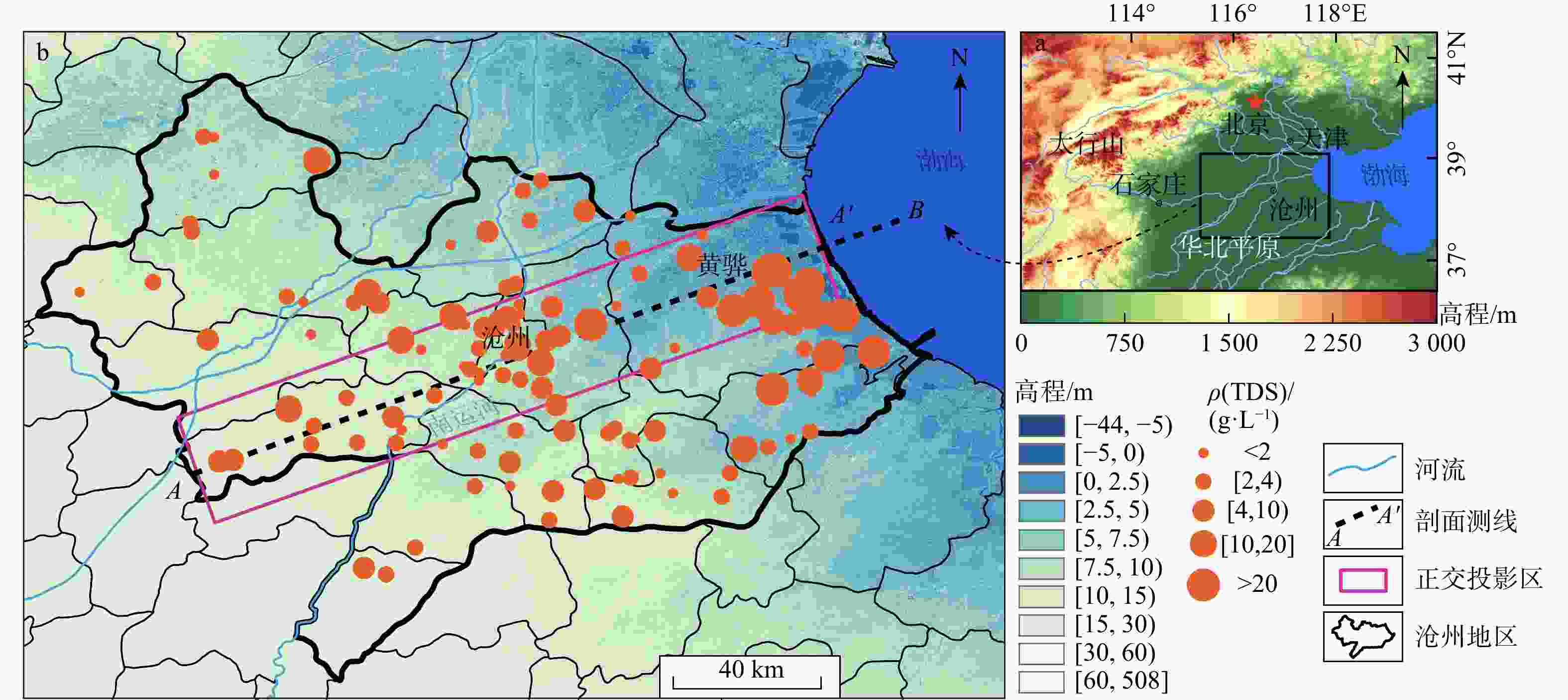
图 1 研究区地理位置(a)和采样点空间分布(b)(正交投影区(粉色矩形框内)的采样点投影于剖面A-A')
Figure 1. Geographic location (a) and spatial distribution of sampling points (b) in the study area
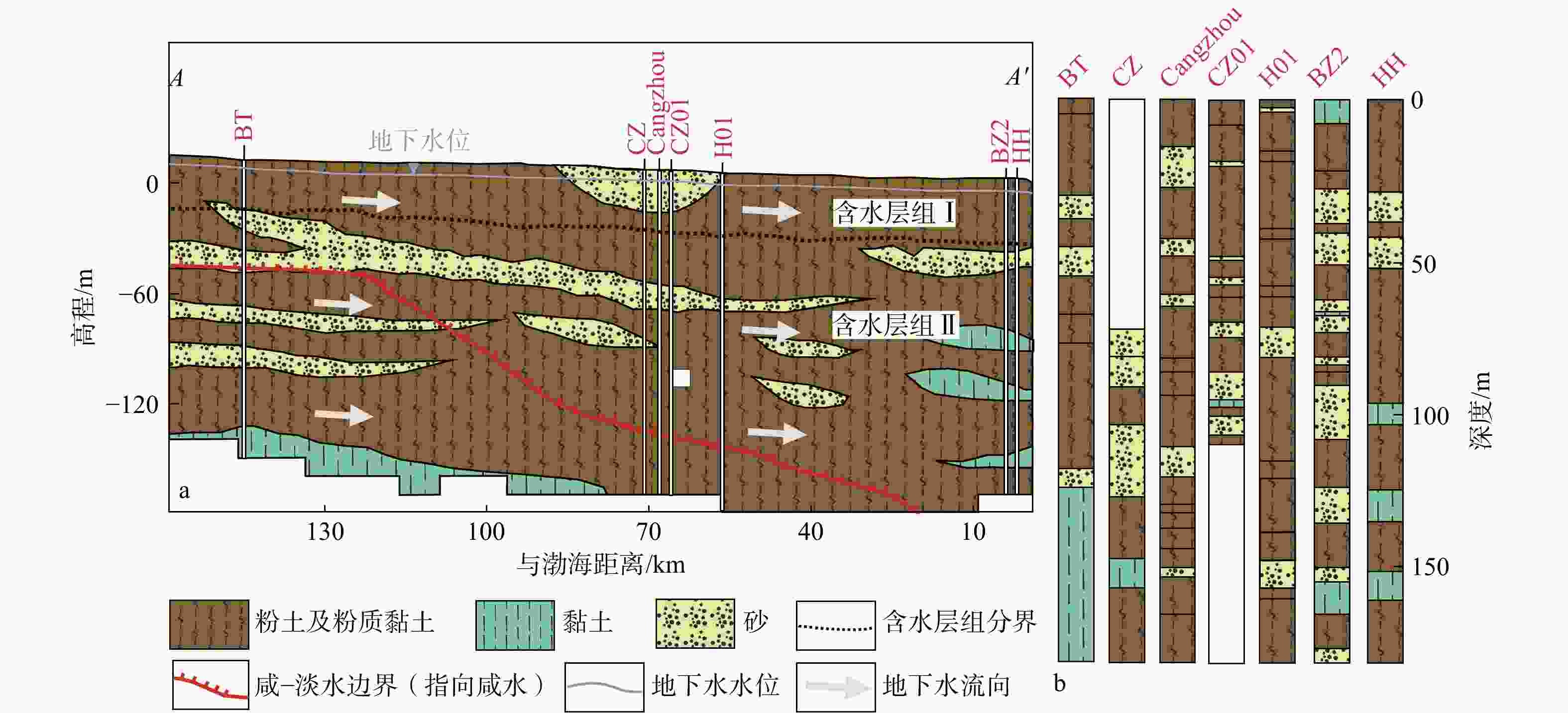
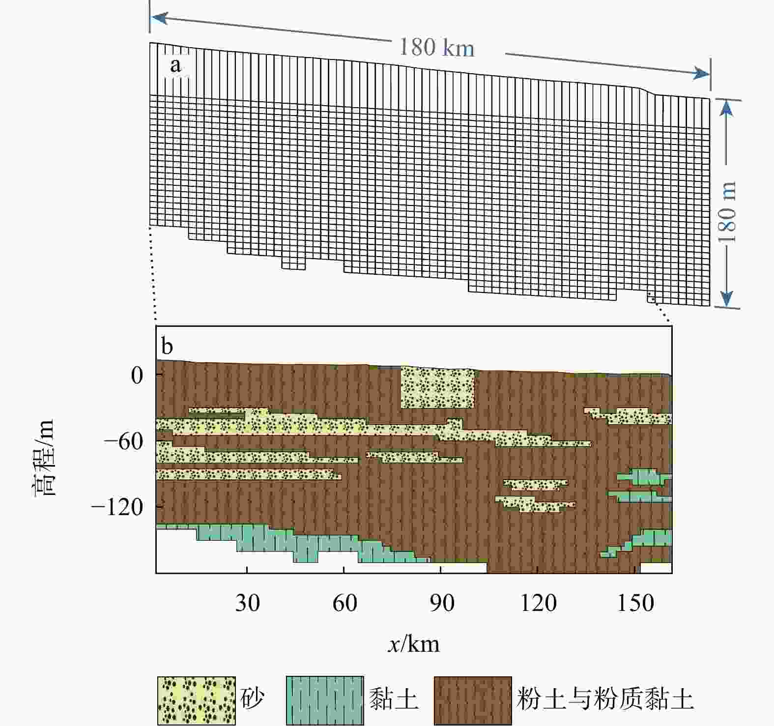
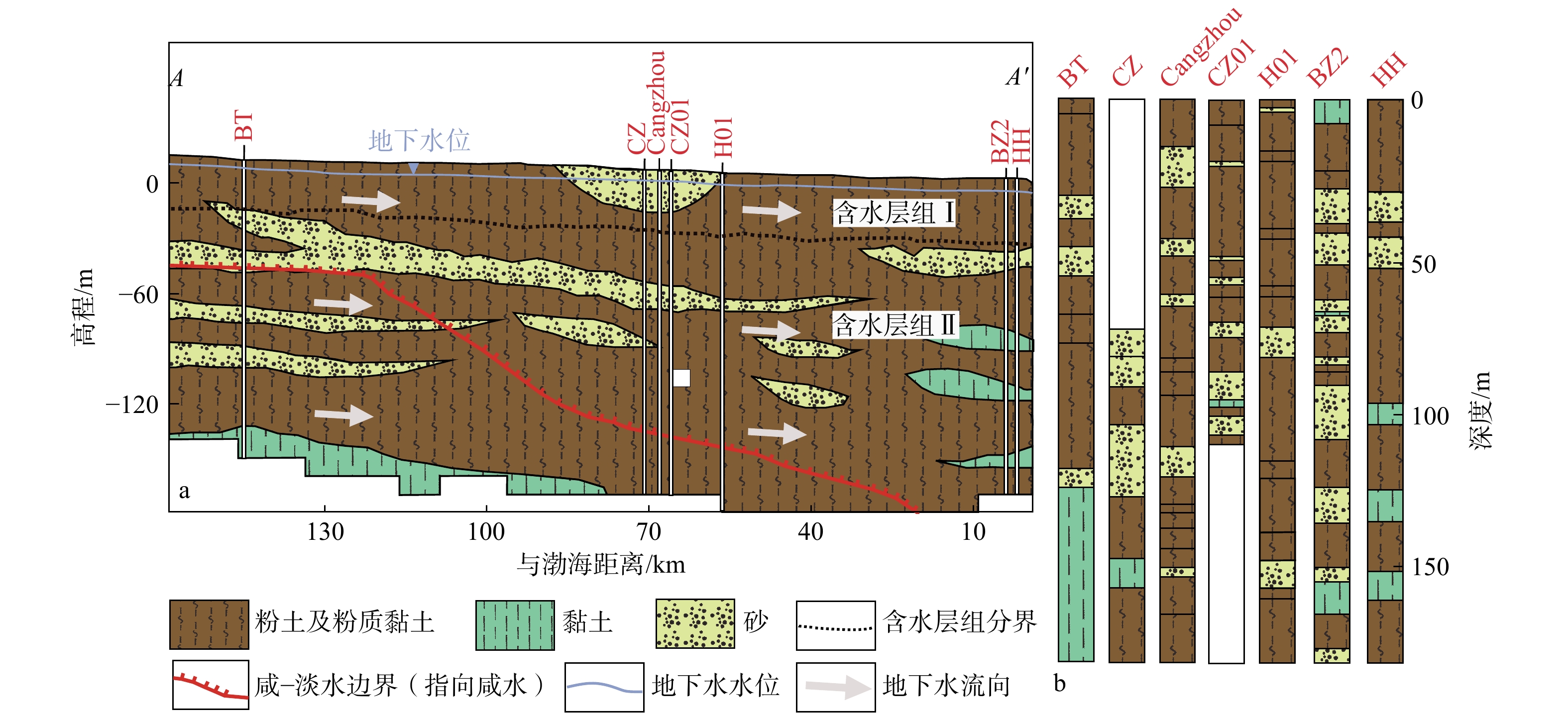
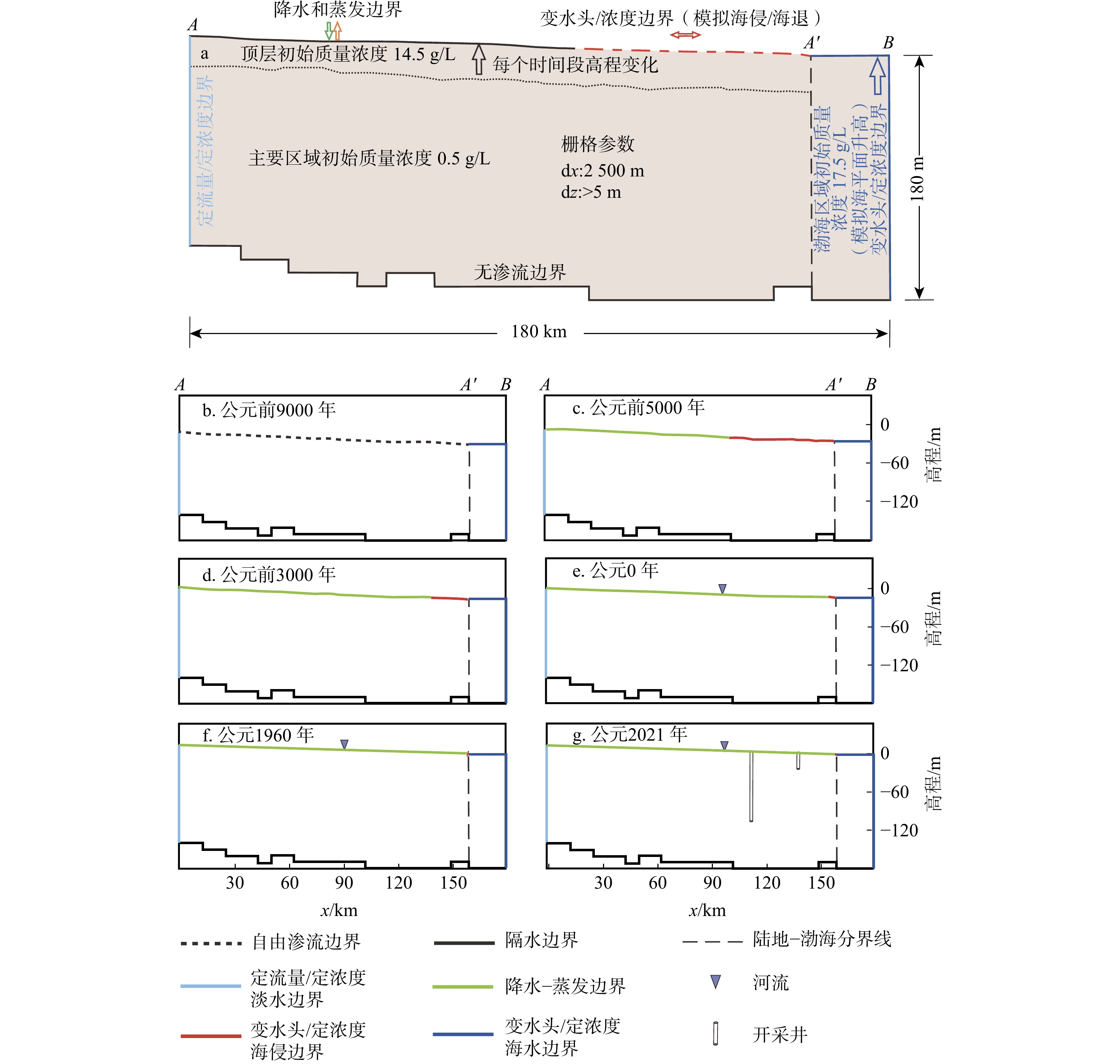
图 6 模型网格剖分(a)和地层结构图(b)
Figure 6. Grid section (a) and stratigraphic structure (b) of model
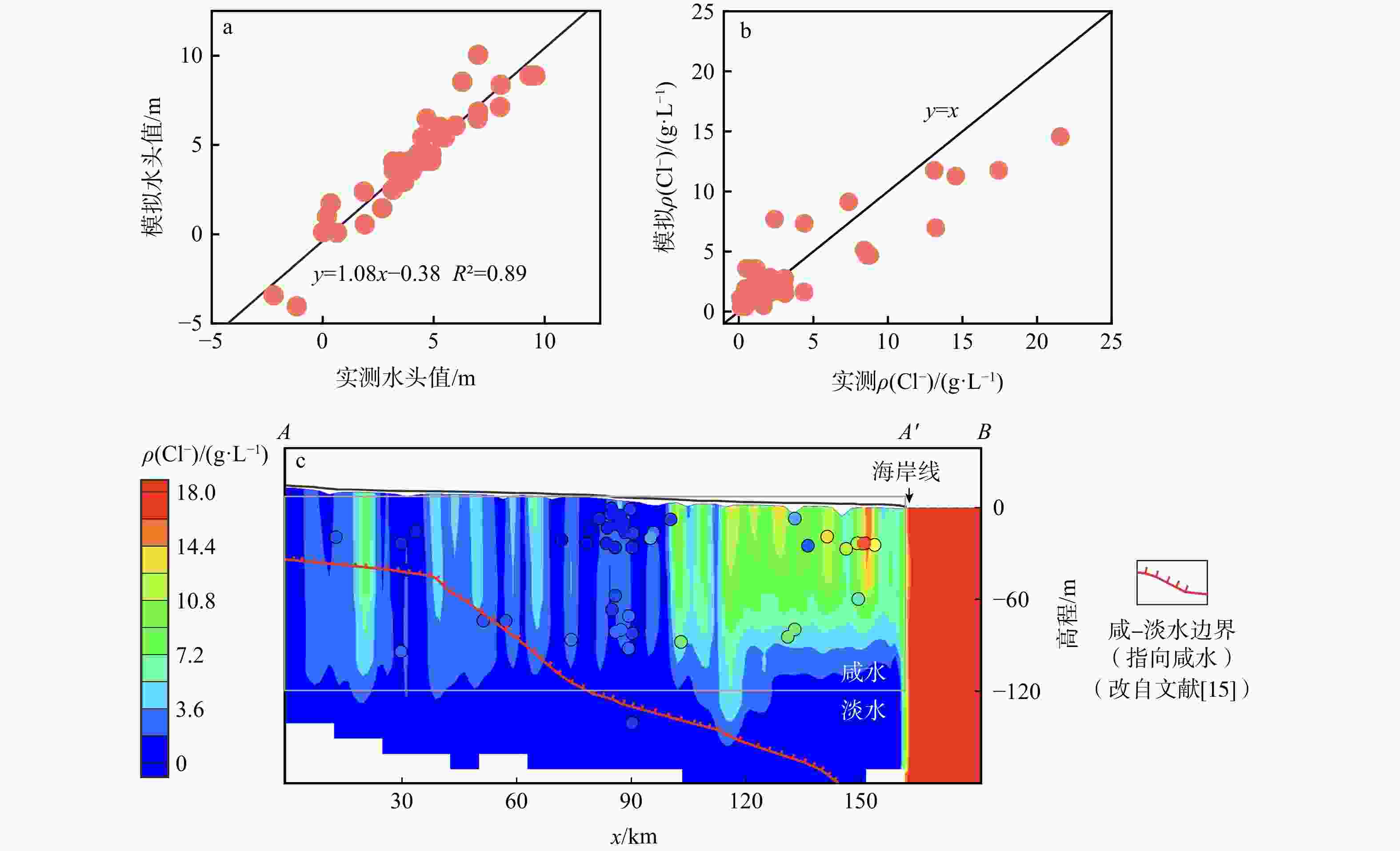
图 7 水头值拟合图(a)和氯离子质量浓度拟合图(b, c)(c图中沿剖面A-A' 30 km宽的缓冲区内的采样点正交投影于剖面上得到相对空间位置)
Figure 7. Water head value fitting graph (a) and chloride ion mass concentration fitting graph (b, c)
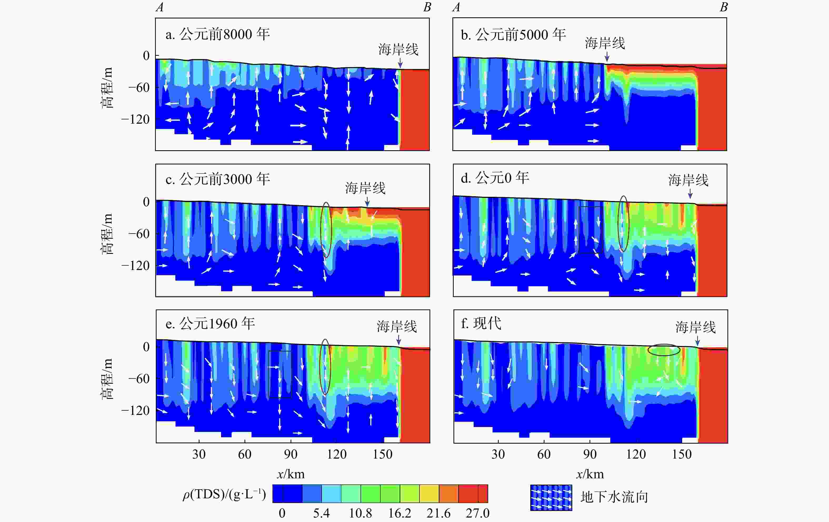
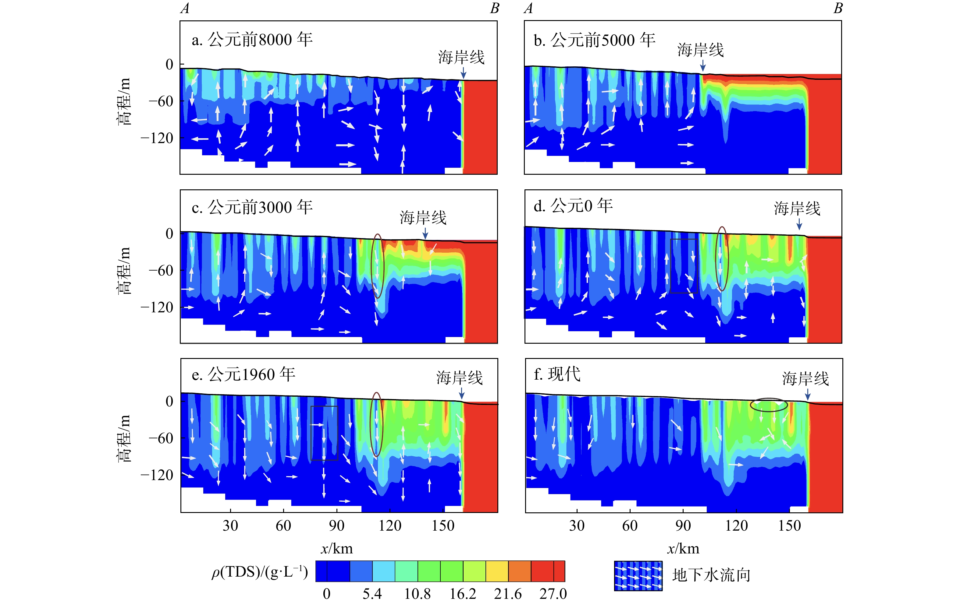
图 8 地下水总溶解性固体(TDS)模拟演化过程
Figure 8. Simulation evolution process of total dissolved solids in groundwater
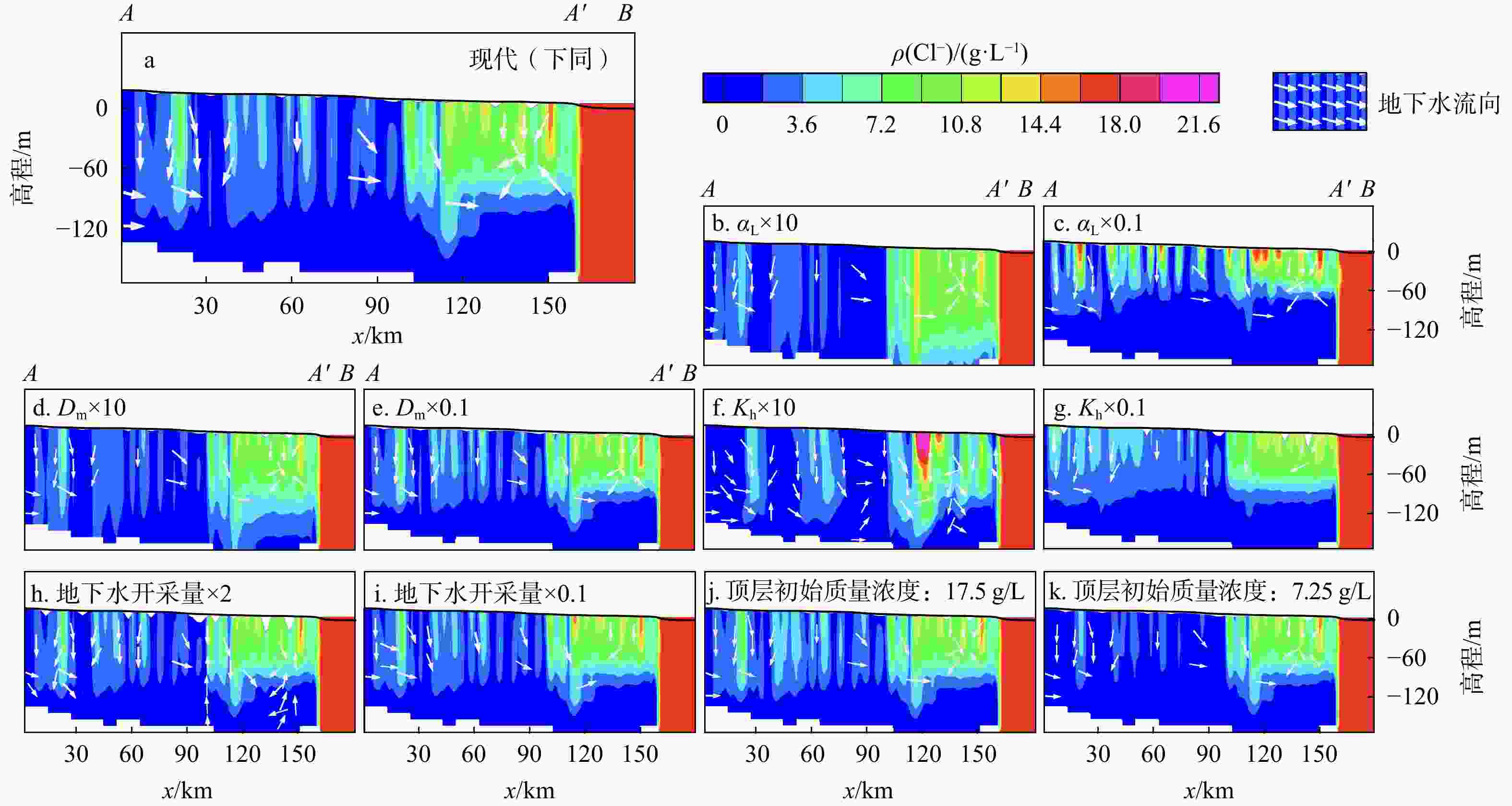
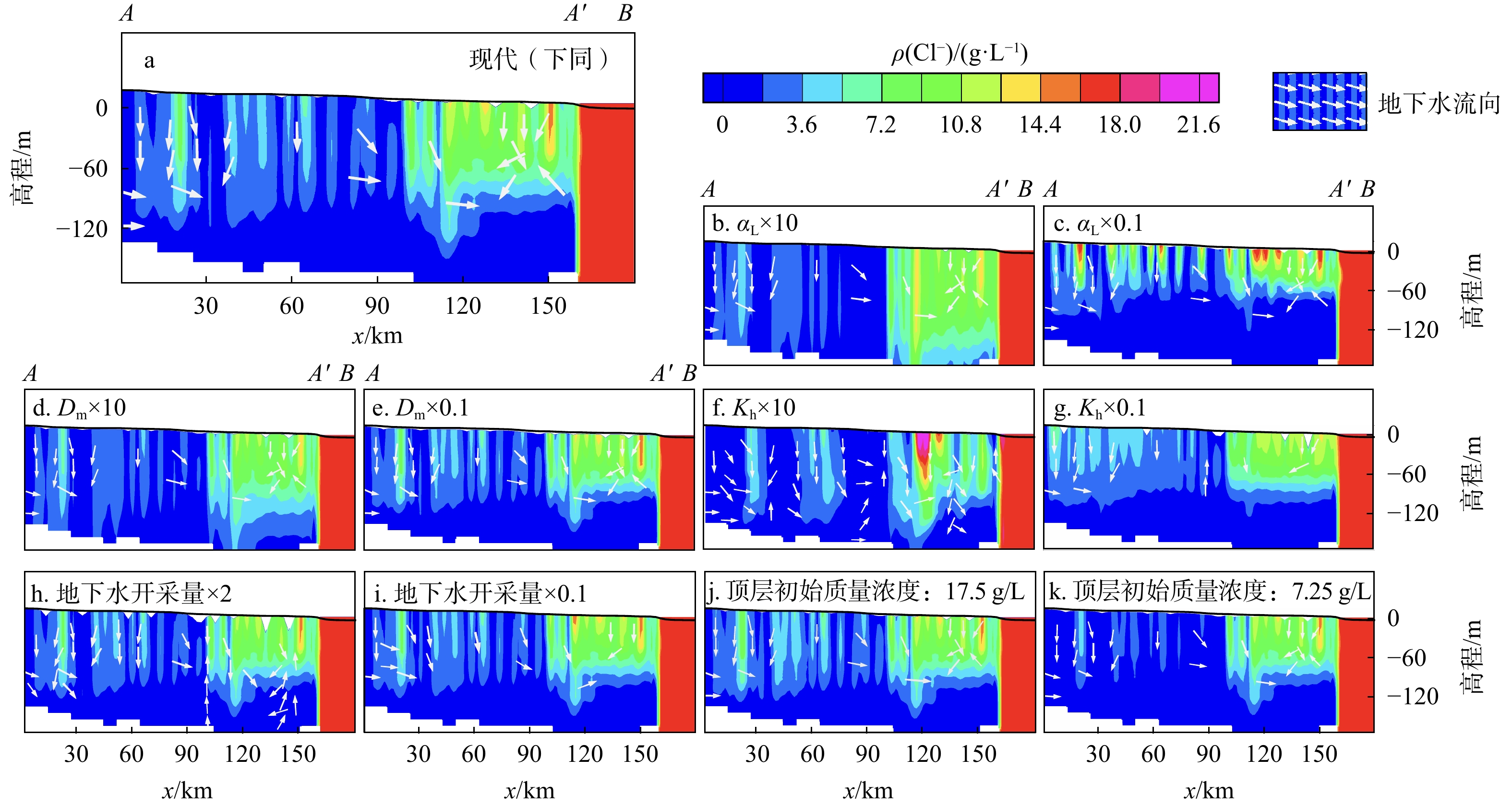
图 9 原始模型(a)及敏感性分析结果(b~k)
αL. 纵向弥散度;Dm. 有效分子扩散系数;Kh. 水平渗透系数
Figure 9. Original model (a) and sensitivity analysis results (b-k)
表 1 气候变化情况[26]
Table 1. Climate change
年代 降水量/mm 蒸发量/mm 气候条件 早全新世(公元前5500 年之前) 480 1202 冷干向暖湿过渡 中全新世
(公元前5500 年−公元前3500 年)998 2350 暖湿 晚全新世
(公元前3500 年−公元前500 年)764 1800 温暖偏干 近现代(公元前500 年−现代) 573 1692 温凉偏干  下载: 导出CSV
表 2 时间段划分及其描述
Table 2. Division and description of model time periods
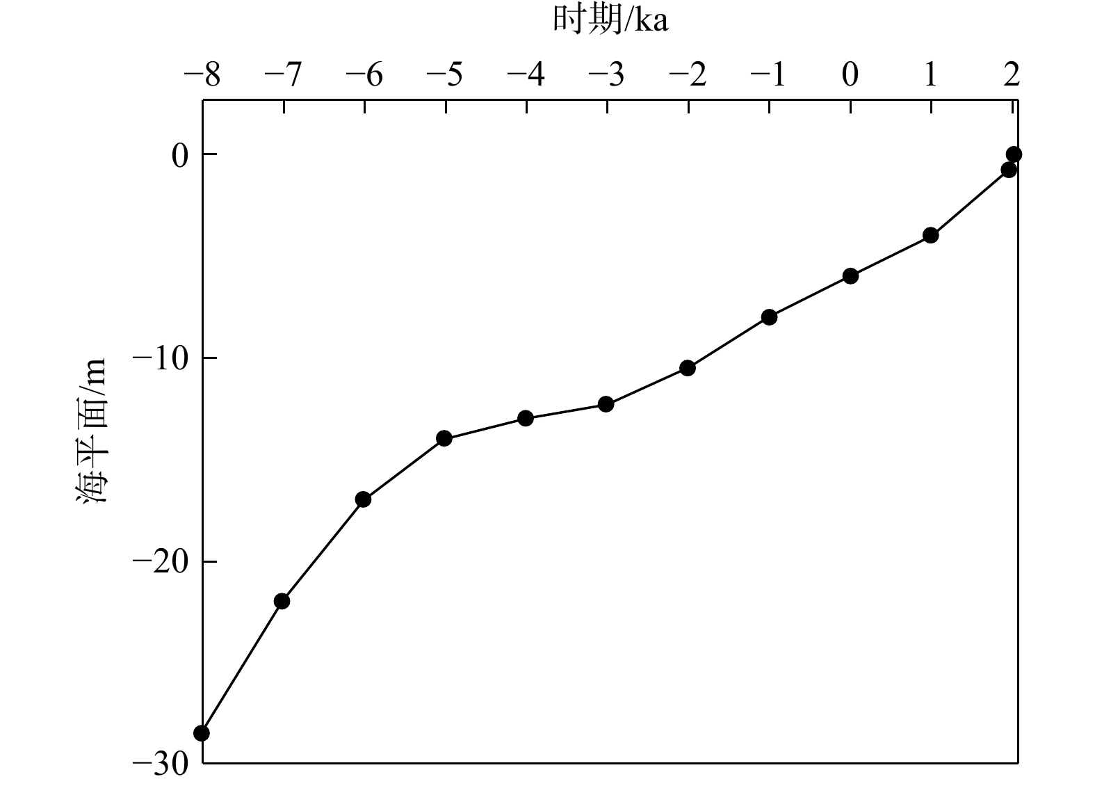
时间段 描述 参考来源 公元前10000 – 公元前9000 年 地表的晚更新世海侵咸水开始下渗 公元前9000 – 公元前8000 年 模型引入降水和蒸发项 文献[26] 公元前8000 – 公元前7000 年 海平面线性升高,由−28.5 m升至−17 m 文献[25] 公元前7000 – 公元前6000 年 平均地表高程升至−13.7 m 文献[15,17] 公元前6000 – 公元前5000 年 全新世海侵到达最大界线 文献[28] 公元前5000 – 公元前4000 年 海平面低速升高,由−14 m升至−12.3 m 文献[25] 公元前4000 – 公元前3000 年 地表最大高程升至2.6 m 文献[15] 公元前3000 – 公元前2000 年 海平面升至−8 m 文献[25] 公元前2000 – 公元前1000 年 海岸线退行至现代海岸线附近 文献[28] 公元前1000 – 公元0 年 在公元前100 年前后,大运河疏浚 公元0 – 公元1000 年 气候转为温凉偏干 文献[29] 公元1000 – 公元1960 年 海岸线移动至当今海岸线位置 文献[28] 公元1960 – 公元2021 年 地下水开采,人类活动增加
下载: 导出CSV
-
[1] LI J, GONG X L, LIANG X, et al. Salinity evolution of aquitard porewater associated with transgression and regression in the coastal plain of eastern China[J]. Journal of Hydrology, 2021, 603: 127050. doi: 10.1016/j.jhydrol.2021.127050 [2] GENG X L, MICHAEL H A. Preferential flow enhances pumping-induced saltwater intrusion in volcanic aquifers[J]. Water Resources Research, 2020, 56(5): e2019WR026390. doi: 10.1029/2019WR026390 [3] DIEU L P, CONG-THI D, SEGERS T, et al. Groundwater salinization and freshening processes in the Luy River coastal aquifer, Vietnam[J]. Water, 2022, 14(15): 2358. doi: 10.3390/w14152358 [4] CANTELON J A, GUIMOND J A, ROBINSON C E, et al. Vertical saltwater intrusion in coastal aquifers driven by episodic flooding: A review[J]. Water Resources Research, 2022, 58(11): e2022WR032614. doi: 10.1029/2022WR032614 [5] HEISS J W, MASE B, SHEN C J. Effects of future increases in tidal flooding on salinity and groundwater dynamics in coastal aquifers[J]. Water Resources Research, 2022, 58(12): e2022WR033195. doi: 10.1029/2022WR033195 [6] HINGST M C, MCQUIGGAN R W, PETERS C N, et al. Surface water-groundwater connections as pathways for inland salinization of coastal aquifers[J]. Groundwater, 2023, 61(5): 626-638. doi: 10.1111/gwat.13274 [7] MORA A, MAHLKNECHT J, LEDESMA-RUIZ R, et al. Dynamics of major and trace elements during seawater intrusion in a coastal sedimentary aquifer impacted by anthropogenic activities[J]. Journal of Contaminant Hydrology, 2020, 232: 103653. doi: 10.1016/j.jconhyd.2020.103653 [8] POST V E A, KOOI H. Rates of salinization by free convection in high-permeability sediments: Insights from numerical modeling and application to the Dutch coastal area[J]. Hydrogeology Journal, 2003, 11(5): 549-559. doi: 10.1007/s10040-003-0271-7 [9] DELSMAN J R, HUANG K R M, VOS P C, et al. Paleo-modeling of coastal saltwater intrusion during the Holocene: An application to the Netherlands[J]. Hydrology and Earth System Sciences, 2014, 18(10): 3891-3905. doi: 10.5194/hess-18-3891-2014 [10] VAN ENGELEN J, OUDE ESSINK G H P, KOOI H, et al. On the origins of hypersaline groundwater in the Nile Delta aquifer[J]. Journal of Hydrology, 2018, 560: 301-317. doi: 10.1016/j.jhydrol.2018.03.029 [11] VAN GEER F C, BUI TRAN V, DUBELAAR W, et al. Paleo-hydrogeological reconstruction of the fresh-saline groundwater distribution in the Vietnamese Mekong Delta since the Late Pleistocene[J]. Journal of Hydrology(Regional Studies), 2019, 23: 100594. [12] WANG S Q, SHAO J L, SONG X F, et al. Application of MODFLOW and geographic information system to groundwater flow simulation in North China Plain, China[J]. Environmental Geology, 2008, 55(7): 1449-1462. doi: 10.1007/s00254-007-1095-x [13] LUO Z J, WANG Y. 3-D variable parameter numerical model for evaluation of the planned exploitable groundwater resource in regional unconsolidated sediments[J]. Journal of Hydrodynamics, 2012, 24(6): 959-968. doi: 10.1016/S1001-6058(11)60324-7 [14] CHEN X X, LUO Z J, ZHOU S L. Influences of soil hydraulic and mechanical parameters on land subsidence and ground fissures caused by groundwater exploitation[J]. Journal of Hydrodynamics, 2014, 26(1): 155-164. doi: 10.1016/S1001-6058(14)60018-4 [15] 张宗祜, 沈照理, 薛禹群, 等. 华北平原地下水环境演化[M]. 北京: 地质出版社, 2000.ZHANG Z H, SHEN Z L, XUE Y Q, et al. Evolution of groundwater environment in North China Plain[M]. Beijing: Geological Publishing House, 2000. (in Chinese) [16] CHEN Z Y, QI J X, XU J M, et al. Paleoclimatic interpretation of the past 30 ka from isotopic studies of the deep confined aquifer of the North China Plain[J]. Applied Geochemistry, 2003, 18(7): 997-1009. doi: 10.1016/S0883-2927(02)00206-8 [17] LIU H Y, GUO H M, POURRET O, et al. Distribution of rare earth elements in sediments of the North China Plain: A probe of sedimentation process[J]. Applied Geochemistry, 2021, 134: 105089. doi: 10.1016/j.apgeochem.2021.105089 [18] 王婷, 邹春辉, 毛龙江, 等. 渤海湾西岸CZ01钻孔沉积物粒度端元分析及其气候−海平面变化响应[J]. 古地理学报, 2022, 24(6): 1224-1237. doi: 10.7605/gdlxb.2022.06.083WANG T, ZOU C H, MAO L J, et al. Sediment grain size end-member analysis and its response to climate and sea-level changes in CZ01 borehole on west coast of Bohai Bay[J]. Journal of Palaeogeography (Chinese Edition), 2022, 24(6): 1224-1237. (in Chinese with English abstract doi: 10.7605/gdlxb.2022.06.083 [19] XUE X B, XIE X J, LI J X, et al. The mechanism of iodine enrichment in groundwater from the North China Plain: Insight from two inland and coastal aquifer sediment boreholes[J]. Environmental Science and Pollution Research, 2022, 29(32): 49007-49028. doi: 10.1007/s11356-021-18078-x [20] KWONG H T, JIAO J J, LIU K, et al. Geochemical signature of pore water from core samples and its implications on the origin of saline pore water in Cangzhou, North China Plain[J]. Journal of Geochemical Exploration, 2015, 157: 143-152. doi: 10.1016/j.gexplo.2015.06.008 [21] 吴忱. 华北地貌环境及其形成演化[M]. 北京: 科学出版社, 2008.WU C. Landform environment and its formation in North China[M]. Beijing: Science Press, 2008. (in Chinese) [22] 刘艳霞, 黄海军, 董慧君, 等. 渤海西南岸全新世最大海侵界线及其地貌特征[J]. 第四纪研究, 2015, 35(2): 340-353. doi: 10.11928/j.issn.1001-7410.2015.02.09LIU Y X, HUANG H J, DONG H J, et al. Geomorphic characteristics and location of the maximum Holocene transgression boundary in the southwestern coast of the Bohai Sea[J]. Quaternary Sciences, 2015, 35(2): 340-353. (in Chinese with English abstract doi: 10.11928/j.issn.1001-7410.2015.02.09 [23] 李曼玥, 张生瑞, 许清海, 等. 华北平原末次冰盛期以来典型时段古环境格局[J]. 中国科学(地球科学), 2019, 49(8): 1269-1277. doi: 10.1360/N072018-00016LI M Y, ZHANG S R, XU Q H, et al. Spatial patterns of vegetation and climate in the North China Plain during the Last Glacial Maximum and Holocene climatic optimum[J]. Scientia Sinica (Terrae), 2019, 49(8): 1269-1277. (in Chinese with English abstract doi: 10.1360/N072018-00016 [24] 陈永胜, 王宏, 李建芬, 等. 渤海湾西岸BT113孔35 ka以来的沉积环境演化与海陆作用[J]. 吉林大学学报(地球科学版), 2012, 42(增刊1): 344-354.CHEN Y S, WANG H, LI J F, et al. Sedimentary environment since 35 ka and terrestrial-marine interaction revealed by borehole BT113 in the western coast of Bohai Bay, China[J]. Journal of Jilin University (Earth Science Edition), 2012, 42(S1): 344-354. (in Chinese with English abstract [25] 庄振业, 林振宏, 刘志杰, 等. 海平面变化及其海岸响应[J]. 海洋地质动态, 2003, 19(7): 1-12. doi: 10.3969/j.issn.1009-2722.2003.07.001ZHUANG Z Y, LIN Z H, LIU Z J, et al. Sea level changes and coastal responses[J]. Marine Geology Letters, 2003, 19(7): 1-12. (in Chinese with English abstract doi: 10.3969/j.issn.1009-2722.2003.07.001 [26] 党显璋. 全新世以来滦河三角洲地下咸(卤)水成因与演化机制研究[D]. 武汉: 中国地质大学(武汉), 2022.DANG X Z. The formation and evolution mechanism of saline groundwater since Holocene in Luanhe River Delta, China[D]. Wuhan: China University of Geosciences(Wuhan), 2022. (in Chinese with English abstract [27] 马青山, 骆祖江. 沧州市地下水开采−地面沉降数值模拟[J]. 水资源保护, 2015, 31(4): 20-26. doi: 10.3880/j.issn.1004-6933.2015.04.004MA Q S, LUO Z J. Numerical simulation of groundwater exploitation and land subsidence in Cangzhou City[J]. Water Resources Protection, 2015, 31(4): 20-26. (in Chinese with English abstract doi: 10.3880/j.issn.1004-6933.2015.04.004 [28] 薛春汀. 7000 年来渤海西岸、南岸海岸线变迁[J]. 地理科学, 2009, 29(2): 217-222. doi: 10.3969/j.issn.1000-0690.2009.02.012XUE C T. Historical changes of coastlines on west and south coasts of Bohai Sea since7000 a B. P.[J]. Scientia Geographica Sinica, 2009, 29(2): 217-222. (in Chinese with English abstract) doi: 10.3969/j.issn.1000-0690.2009.02.012[29] LIU J H, XU H, QIN D Y, et al. Water cycle evolution in the Haihe River basin in the past 10000 years[J]. Chinese Science Bulletin, 2013, 58(27): 3312-3319. doi: 10.1007/s11434-012-5609-x[30] LANGEVIN C D, THORNE JR D T, DAUSMAN A M, et al. SEAWAT version 4: A computer program for simulation of multi-species solute and heat transport [R]. Reston, Virginia, USA: United States Geological Survey, 2008. [31] 陈开荣, 陈汉宝, 赵海亮. 基于SEAWAT的海水入侵数值模拟[J]. 水资源与水工程学报, 2012, 23(6): 140-145. doi: 10.11705/j.issn.1672-643X.2012.06.033CHEN K R, CHEN H B, ZHAO H L. Three-dimensional numerical simulation of seawater intrusion based on SEAWAT[J]. Journal of Water Resources and Water Engineering, 2012, 23(6): 140-145. (in Chinese with English abstract doi: 10.11705/j.issn.1672-643X.2012.06.033 [32] 董贵明, 王颖, 詹红兵, 等. 二维承压非稳定流水均衡区间的数值模拟[J]. 地质科技通报, 2023, 42(4): 75-82.DONG G M, WANG Y, ZHAN H B, et al. Numerical simulation of the water budget interval for unsteady two-dimensional confined flow[J]. Bulletin of Geological Science and Technology, 2023, 42(4): 75-82. (in Chinese with English abstract [33] 姚孟, 于胜超, 张可馨, 等. 基于MARUN的海岸带地下水渗流及溶质运移过程研究进展[J]. 地质科技通报, 2023, 42(4): 170-182.YAO M, YU S C, ZHANG K X, et al. Research progress on coastal groundwater flow and solute transport processes based on MARUN[J]. Bulletin of Geological Science and Technology, 2023, 42(4): 170-182. (in Chinese with English abstract [34] 邢磊, 焦静娟, 刘雪芹, 等. 渤海海域浅层气分布及地震特征分析[J]. 中国海洋大学学报(自然科学版), 2017, 47(11): 70-78.XING L, JIAO J J, LIU X Q, et al. Distribution and seismic reflection characteristics of shallow gas in Bohai Sea[J]. Periodical of Ocean University of China, 2017, 47(11): 70-78. (in Chinese with English abstract [35] CAO G L, ZHENG C M, SCANLON B R, et al. Use of flow modeling to assess sustainability of groundwater resources in the North China Plain[J]. Water Resources Research, 2013, 49(1): 159-175. doi: 10.1029/2012WR011899 [36] LIU Y P, YAMANAKA T, ZHOU X, et al. Combined use of tracer approach and numerical simulation to estimate groundwater recharge in an alluvial aquifer system: A case study of Nasunogahara area, central Japan[J]. Journal of Hydrology, 2014, 519: 833-847. doi: 10.1016/j.jhydrol.2014.08.017 [37] TANG R, HAN X D, WANG X G, et al. Optimized main ditch water control for agriculture in northern Huaihe River Plain, Anhui Province, China, using MODFLOW groundwater table simulations[J]. Water, 2022, 14(1): 29. [38] EISSA M A, THOMAS J M, POHLL G, et al. Groundwater recharge and salinization in the arid coastal plain aquifer of the Wadi Watir Delta, Sinai, Egypt[J]. Applied Geochemistry, 2016, 71: 48-62. doi: 10.1016/j.apgeochem.2016.05.017 [39] HAN D M, CAO G L, CURRELL M J, et al. Groundwater salinization and flushing during glacial-interglacial cycles: Insights from aquitard porewater tracer profiles in the North China Plain[J]. Water Resources Research, 2020, 56(11): e2020WR027879. doi: 10.1029/2020WR027879 [40] BATLLE-AGUILAR J, COOK P G, HARRINGTON G A. Comparison of hydraulic and chemical methods for determining hydraulic conductivity and leakage rates in argillaceous aquitards[J]. Journal of Hydrology, 2016, 532: 102-121. doi: 10.1016/j.jhydrol.2015.11.035 [41] 史洪飞, 哈建强, 李瑞森, 等. 沧州地下水超采与生态环境演变及控制措施[J]. 南水北调与水利科技, 2008, 6(6): 72-74. doi: 10.3969/j.issn.1672-1683.2008.06.021SHI H F, HA J Q, LI R S, et al. Groundwater overexploitation and ecological environment evolution and controlling measures in Cangzhou City[J]. South-to-North Water Transfers and Water Science & Technology, 2008, 6(6): 72-74. (in Chinese with English abstract doi: 10.3969/j.issn.1672-1683.2008.06.021 [42] CAO G L, HAN D M, CURRELL M J, et al. Revised conceptualization of the North China Basin groundwater flow system: Groundwater age, heat and flow simulations[J]. Journal of Asian Earth Sciences, 2016, 127: 119-136. doi: 10.1016/j.jseaes.2016.05.025 [43] SHEN C J, ZHANG C M, KONG J, et al. Solute transport influenced by unstable flow in beach aquifers[J]. Advances in Water Resources, 2019, 125: 68-81. doi: 10.1016/j.advwatres.2019.01.009 [44] 肖勋, 施文光, 王全荣. 井内混合效应与尺度效应对注入井附近溶质径向弥散过程的影响[J]. 地球科学, 2020, 45(4): 1439-1446.XIAO X, SHI W G, WANG Q R. Effect of mixing effect and scale-dependent dispersion for radial solute transport near the injection well[J]. Earth Science, 2020, 45(4): 1439-1446. (in Chinese with English abstract [45] CHANG Y W, HU B X, XU Z X, et al. Numerical simulation of seawater intrusion to coastal aquifers and brine water/freshwater interaction in south coast of Laizhou Bay, China[J]. Journal of Contaminant Hydrology, 2018, 215: 1-10. doi: 10.1016/j.jconhyd.2018.06.002 [46] KAZMIERCZAK J, MÜLLER S, NILSSON B, et al. Groundwater flow and heterogeneous discharge into a seepage lake: Combined use of physical methods and hydrochemical tracers[J]. Water Resources Research, 2016, 52(11): 9109-9130. doi: 10.1002/2016WR019326 -

 下载:
下载:


 点击查看大图

计量
- 文章访问数: 535
- PDF下载量: 57
- 被引次数: 0

