


Key technology and application of integrated management of urban pan-spatial 3D model data
-
摘要:
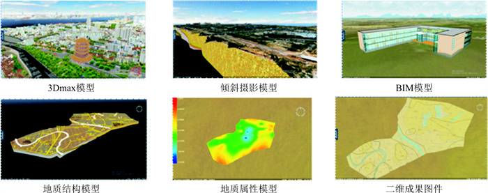
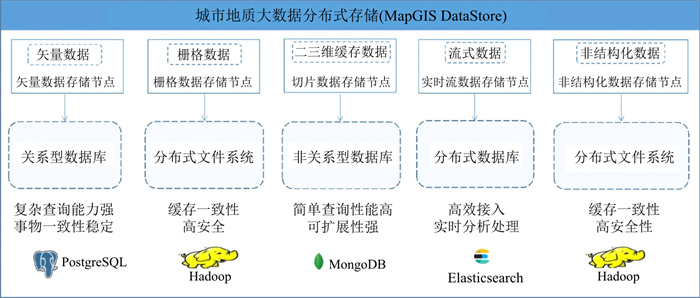
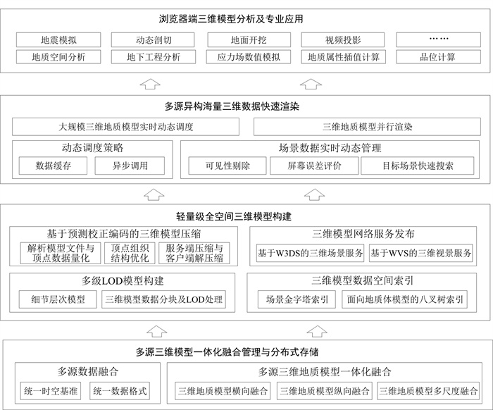
随着城市三维地质信息系统及其应用的快速发展,对地学数据的可视化表达精度的需求变得越来越高,但地质调查数据常具有多源、多维、海量、多专题、多尺度和多时态等特征,而三维数据存储、组织与管理己成为制约其发展的重要因素。因此如何高效管理并有效利用这些复杂且海量的地质数据去解决各种复杂的地质问题服务社会,成为了城市地质信息科学领域研究的热门方向。基于武汉市多要素城市地质调查全空间一张图的构建过程,从多源三维模型一体化融合管理与分布式存储、轻量级全空间三维模型构建、多源异构海量三维数据快速渲染和浏览器端三维模型分析及专业应用4个方面系统地探索了城市地质调查全空间一张图系统建设过程中的关键技术,并进行了应用实践。研究结果实现了城市级大规模高精度三维地质模型的高效集成,提高了多要素城市地质调查成果可视化的表达效果,为三维地质模型的应用奠定了坚实的基础。
Abstract:With the rapid development of urban 3D geological information system and its application, the demand for visualization accuracy of geological data is increasing. Geological survey data are often multi-source, multi-dimensional, massive, multi-topic, multi-scale and multi-temporal, which makes it difficult to store, organize and manage 3D data.Therefore, it is of great interest for scholars in the field of urban geological information science to efficiently manage and effectively utilize the complex and massive geological data to solve various complex geological problems and serve the society. Based on the construction process of a full-space map of the multi-factor urban geological survey of Wuhan, this paper systematically explores the key technologies in the construction of the One Map system for urban geological survey and puts them into practice. Four aspects are explicitly considered, namely, distributed storage and fusion management of a multi-source 3D models, lightweight full-space 3D model construction, fast rendering of multi-source heterogeneous massive 3D data, and application of 3D model analysis in browser, and an example is put forward. It realizes the efficient integration of large-scale and high-precision 3D geological models at the city level, improves the visualization expression effect of multi-factor urban geological survey results, and lays a solid foundation for the application of 3D geological models.
-
表 1 部署平台的软硬件条件
Table 1. Sorfware and hardware conditions of the deployment platform
区域 系统名称/用途 硬件参数 操作系统 应用云 应用服务器 4核,16G,磁盘大小:1T Windows Server 2008 服务云 IGServer服务器+IGServer-X服务器 8核,32G,磁盘大小:2T Windows Server 2008(或以上) 数据云 DataStore数据服务 单节点16核,32G,磁盘大小:2T Centos 7  下载: 导出CSV
-
[1] 黄少芳, 刘晓鸿. 地质大数据应用与地质信息化发展的思考[J]. 中国矿业, 2016, 25(8): 166-170. doi: 10.3969/j.issn.1004-4051.2016.08.035Huang S F, Liu X H. Think about the application of geological big data and geological information development[J]. China Mining Magazine, 2016, 25(8): 166-170 (in Chinese with English abstract). doi: 10.3969/j.issn.1004-4051.2016.08.035 [2] 陈建平, 李婧, 崔宁, 等. 大数据背景下地质云的构建与应用[J]. 地质通报, 2015, 34(7): 1260-1265. doi: 10.3969/j.issn.1671-2552.2015.07.002Chen J P, Li J, Cui N, et al. The construction and application of geological cloud under the big data background[J]. Geological Bulletin of China, 2015, 34(7): 1260-1265 (in Chinese with English abstract). doi: 10.3969/j.issn.1671-2552.2015.07.002 [3] 张生德, 王磊. 三维可视地理信息系统在城市规划中的应用研究[J]. 中国图象图形学报, 2001, 6(9): 123-127. https://www.cnki.com.cn/Article/CJFDTOTAL-ZGTB200109021.htmZhang S D, Wang L. Application of 3D visual geographic information system in urban planning[J]. Journal of Image and Graphics, 2001, 6(9): 123-127 (in Chinese with English abstract). https://www.cnki.com.cn/Article/CJFDTOTAL-ZGTB200109021.htm [4] 王永志, 包晓栋, 缪谨励, 等. 基于大数据的地质云监控平台建设与应用[J]. 地球物理学进展, 2018, 33(2): 850-859. https://www.cnki.com.cn/Article/CJFDTOTAL-DQWJ201802054.htmWang Y Z, Bao X D, Miao J L, et al. Construction and application of GeoCloud monitoring platform based on big data[J]. Progress in Geophysics, 2018, 33(2): 850-859 (in Chinese with English abstract). https://www.cnki.com.cn/Article/CJFDTOTAL-DQWJ201802054.htm [5] 王成善, 周成虎, 彭建兵, 等. 论新时代我国城市地下空间高质量开发和可持续利用[J]. 地学前缘, 2019, 26(3): 1-8. https://www.cnki.com.cn/Article/CJFDTOTAL-DXQY201903003.htmWang C S, Zhou C H, Peng J B, et al. A discussion on high quality development and sustainable utilization of China's urban underground space in the new area[J]. Earth Science Frontiers, 2019, 26(3): 1-8 (in Chinese with English abstract). https://www.cnki.com.cn/Article/CJFDTOTAL-DXQY201903003.htm [6] 吴冲龙, 刘刚, 张夏林, 等. 地质科学大数据及其利用的若干问题探讨[J]. 科学通报, 2016, 61(16): 1797-1807. https://www.cnki.com.cn/Article/CJFDTOTAL-KXTB201616011.htmWu C L, Liu G, Wang L Z, et al. Disscussion on geological science big data and its applications[J]. Chinese Science Bulletin, 2016, 61(16): 1797-1807 (in Chinese with English abstract). https://www.cnki.com.cn/Article/CJFDTOTAL-KXTB201616011.htm [7] 吴冲龙, 刘刚, 王力哲, 等. 基于大数据的城市地质环境智能监管思路与方法[J]. 地质科技通报, 2020, 39(1): 157-163. doi: 10.19509/j.cnki.dzkq.2020.0117Wu C L, Liu G, Wang L Z, et al. Thinking and methods of intelligent supervision of urban geological environment based on big data[J]. Bulletin of Geological Science and Technology, 2020, 39(1): 157-163 (in Chinese with English abstract). doi: 10.19509/j.cnki.dzkq.2020.0117 [8] 容东林, 尚建嘎, 甘地. 城市三维地质信息系统建设统一过程方法与实践[J]. 地质科技情报, 2016, 35(1): 212-217. https://www.cnki.com.cn/Article/CJFDTOTAL-DZKQ201601033.htmRong D L, Shang J G, Gan D. Unified process for the building of 3D urban geological information system[J]. Geological Science and Technology Information, 2016, 35(1): 212-217 (in Chinese with English abstract). https://www.cnki.com.cn/Article/CJFDTOTAL-DZKQ201601033.htm [9] 宋越, 高振记, 王鹏. 基于大数据技术的云端城市地质三维可视化框架[J]. 中国矿业, 2020, 29(6): 81-86. https://www.cnki.com.cn/Article/CJFDTOTAL-ZGKA202006014.htmSong Y, Gao Z J, Wang P. Framework of 3D visualization for city geology in cloud platform based on big data technique[J]. China Mining Magazine, 2020, 29(6): 81-86 (in Chinese with English abstract). https://www.cnki.com.cn/Article/CJFDTOTAL-ZGKA202006014.htm [10] 宋越, 高振记, 吴自兴, 等. 地上地下一体化三维可视化平台基本技术框架[J]. 地质论评, 2019, 65(增刊1): 309-310. https://www.cnki.com.cn/Article/CJFDTOTAL-DZLP2019S1146.htmSong Y, Gao Z J, Wu Z X, et al. The basic technical framework of the ground and underground integrated 3D visualization platform[J]. Geological Review, 2019, 65(S1): 309-310 (in Chinese with English abstract). https://www.cnki.com.cn/Article/CJFDTOTAL-DZLP2019S1146.htm [11] 阮明, 钱婷. 城市地下空间三维可视化平台研究[J]. 地理空间信息, 2020, 18(4): 34-37. https://www.cnki.com.cn/Article/CJFDTOTAL-DXKJ202004008.htmRuan M, Qian T. Research on 3D visualization platform of urban underground space[J]. Geospatial Information, 2020, 18(4): 34-37 (in Chinese with English abstract). https://www.cnki.com.cn/Article/CJFDTOTAL-DXKJ202004008.htm [12] 李佳伟. 三维城市空间一体化集成建模技术研究[D]. 成都: 成都理工大学, 2019.Li J W. Research on integrated modeling technology of 3D urban space[D]. Chengdu: Chengdu University of Technology, 2019 (in Chinese with English abstract). [13] 刘彦锋, 张文彪, 段太忠, 等. 深度学习油气藏地质建模研究进展[J]. 地质科技通报, 2021, 40(4): 235-241. doi: 10.19509/j.cnki.dzkq.2021.0417Liu Y F, Zhang W B, Duan T Z, et al. Progress of deep learning in oil and gas reservoir geological modeling[J]. Bulletin of Geological Science and Technology, 2021, 40(4): 235-241 (in Chinese with English abstract). doi: 10.19509/j.cnki.dzkq.2021.0417 [14] 晏四方, 郭亮, 粟梽桐, 等. 二三维一体化的城市三维仿真应用系统设计与实现: 以琶洲为例[J]. 测绘与空间地理信息, 2018, 41(4): 69-71. https://www.cnki.com.cn/Article/CJFDTOTAL-DBCH201804020.htmYan S F, Guo L, Li Z T, et al. Design and implementation of two or three dimensional integrated urban 3D simulation application system: Taking Pazhou as an example[J]. Geomatics & Spatial Information Technology, 2018, 41(4): 69-71 (in Chinese with English abstract). https://www.cnki.com.cn/Article/CJFDTOTAL-DBCH201804020.htm [15] 刘北胜. 基于云渲染的三维BIM模型可视化技术研究[J]. 北京交通大学学报, 2017, 41(6): 107-113. https://www.cnki.com.cn/Article/CJFDTOTAL-BFJT201706019.htmLiu B S. Research on cloud rendering based 3D BIM model visualization techniques[J]. Journal of Beijing Jiaotong University, 2017, 41(6): 107-113 (in Chinese with English abstract). https://www.cnki.com.cn/Article/CJFDTOTAL-BFJT201706019.htm [16] 孟耀伟, 孙毅中. 一种三维建筑物模型与数据组织方法[J]. 测绘科学, 2017, 42(9): 138-142. https://www.cnki.com.cn/Article/CJFDTOTAL-CHKD201709026.htmMeng Y W, Sun Y Z. A method for 3D building model and data organization[J]. Science of Surveying and Mapping, 2017, 42(9): 138-142 (in Chinese with English abstract). https://www.cnki.com.cn/Article/CJFDTOTAL-CHKD201709026.htm [17] 魏振华, 刘志锋, 李金萍, 等. 基于要素扩展管理的海量地质空间数据存储模型的设计与实现[J]. 计算机应用与软件, 2014, 31(7): 36-39. https://www.cnki.com.cn/Article/CJFDTOTAL-JYRJ201407011.htmWei Z H, Liu Z F, Li J P, et al. Design and realization of massive Geo-spatial data storage model based on feature expanding management[J]. Computer Application and Software, 2014, 31(7): 36-39 (in Chinese with English abstract). https://www.cnki.com.cn/Article/CJFDTOTAL-JYRJ201407011.htm [18] 刘军旗, 刘强, 刘千慧, 等. 大数据时代地质灾害数据管理及应用模式探讨[J]. 地质科技通报, 2021, 40(6): 276-282, 292. doi: 10.19509/j.cnki.dzkq.2021.0627Liu J Q, Liu Q, Liu Q H, et al. Discussion of geological hazard data management and application model in big data era[J]. Bulletin of Geological Science and Technology, 2021, 40(6): 276-282, 292 (in Chinese with English abstract). doi: 10.19509/j.cnki.dzkq.2021.0627 [19] 王想红, 屈红刚, 王占刚. 基于Geo3DML的三维地质模型数据管理研究[J]. 中国矿业, 2016, 25(增刊2): 100-103. https://www.cnki.com.cn/Article/CJFDTOTAL-ZGKA2016S2027.htmWang X H, Qu H G, Wang Z G. Research on data management of three-dimensional geological model based on Geo3DML[J]. China Mining Magazine, 2016, 25(S2): 100-103 (in Chinese with English abstract). https://www.cnki.com.cn/Article/CJFDTOTAL-ZGKA2016S2027.htm [20] 田宜平, 吴冲龙, 翁正平, 等. 地质大数据可视化关键技术探讨[J]. 地质科技通报, 2020, 39(4): 29-36. doi: 10.19509/j.cnki.dzkq.2020.0404Tian Y P, Wu C L, Weng Z P, et al. Key technologies of geological big data visualization[J]. Bulletin of Geological Science and Technology, 2020, 39(4): 29-36(in Chinese with English abstract). doi: 10.19509/j.cnki.dzkq.2020.0404 -

 下载:
下载:

 点击查看大图
计量
- 文章访问数: 1301
- PDF下载量: 125
- 被引次数: 0

