


Applications status and prospects for using unmanned aerial vehicle in sedimentology
-
摘要:
无人机是获取地表数字图像和进行样品采集的重要手段,近年来在沉积学领域正逐渐成为一种新兴的研究手段,改变着沉积学的研究范式。然而,目前国内基于无人机的沉积学研究尚处在起步阶段,本研究拟回顾近年来无人机在沉积学领域研究中的重要应用,对所涉及的关键技术背景和存在的问题进行了讨论,总结并展望了未来的发展前景,以期对后续相关研究提供参考。主要从沉积露头的三维数字重建、高分辨率沉积结构和构造特征的提取以及无人机协助样品采集3个方面综述了无人机在沉积学应用中的软硬件要求及典型研究案例。利用无人机摄影测量技术构建数字露头模型,有利于从多个空间尺度和视角观察沉积露头的几何形态、沉积相与岩相组合情况,结合数字露头模型信息提取软件,可对粒度、交错层理和生物遗迹等沉积结构和构造特征进行大范围的远程而高效的提取,未来还可进一步应用于沉积学野外实践教学工作中。此外,对无人机本身进行改造,还能够协助进行冰心等沉积物样品的采集。应用无人机技术进行沉积学研究,具有低成本和高效率的优势,保证了数据的时效性和连续性,也提高了野外工作的安全性。但是,无人机技术在数据可重复性、点云处理以及图像与模型质量方面也存在着不足。未来可借助人工智能方法,以及通过制定无人机图像采集与处理流程的标准规范来进一步改善。
Abstract:The unmanned aerial vehicle (UAV) is an important tool for acquiring digital images of the surface and collecting samples. Recently, it has been becoming an emerging research tool in sedimentology, changing the paradigm of sedimentology.However, UAV-based sedimentological research in China is still in its infancy. This paper reviews the recently important applications of UAVs in sedimentology, discusses critical technical backgrounds and existing problems involved, and summarizes as well as prospects for future applications of UAVs in sedimentology to provide references for subsequent research.Software and hardware requirements for applications of UAVs in sedimentology and typical case studies are reviewed from three aspects: 3D digital reconstruction of sedimentary outcrops, extraction of high-resolution sedimentary textures and structure features, and UAV-assisted sample collection. The use of UAV photogrammetry to construct digital outcrop models facilitates the observation of geometry, sedimentary facies, and facies associations for sedimentary outcrops from multiple spatial scales and perspectives. Combined with professional software for digital outcrop model interpretations, it allows for remote and efficient extractions of sedimentary textures and structure features such as grain size, cross-bedding, and bioglyph on large spatial scales. UAV-based digital outcrop models can also be applied to field practice teaching in sedimentology in the future. Also, UAVs can be modified to assist in collecting sediment samples like ice cores. The application of the UAV technology in sedimentological research has the advantages of low cost and high efficiency, ensuring the timeliness and continuity of data, and increasing safety in fieldwork. However, UAV technology also has disadvantages in data repeatability, point cloud processing, and image or model quality. Further improvements can be made in the future with the help of artificial intelligence and by developing standard specifications for UAV image acquisition and processing flow.
-

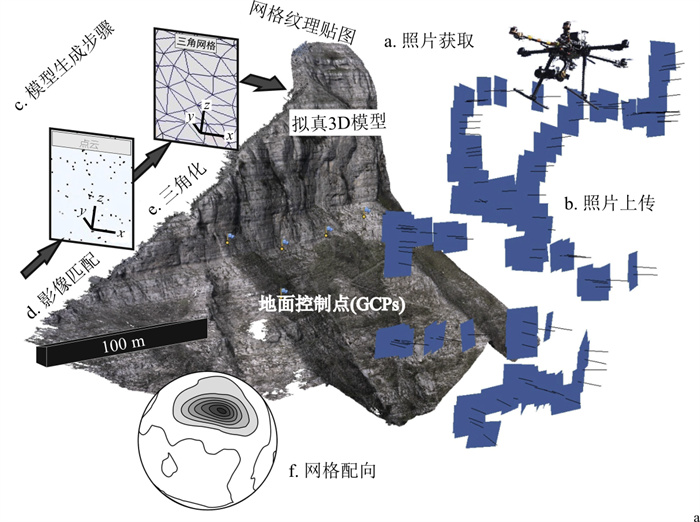
图 1 利用无人机摄影测量技术构建数字露头模型的工作流程[9]
Figure 1. Workflow for the creation of digital outcrop models using UAV-based photogrammetry

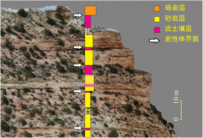
图 2 叠加岩性剖面的Richards山西部数字露头模型[7]
Figure 2. Digital outcrop model from the western end of Richards Mountain with alithological profile overlain on it

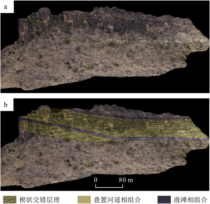
图 3 Bima组剖面的数字露头模型(a)及其岩相组合解释(b)图[11]
Figure 3. Digital outcrop model for the profile of Bima Formation (a) and interpretations for facies association (b)

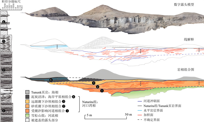
图 4 美国犹他州西部白垩系Naturita组Mesa Butte剖面的数字露头模型及对应的岩相组合图[12]
Figure 4. Digital outcrop model for the profile of Mesa Butte of Cretaceous Naturita Formation and corresponding facies association map

图 5 LIME软件中的面板投影操作[13]
a.将线要素投影至面板上并导出;b.在图像编辑器中填充闭合多边形,创建解释面板;c.在面板上叠加经过填充的闭合多边形;d.解释面板作为新的纹理层投影到数字露头模型上
Figure 5. Panel projection in LIME

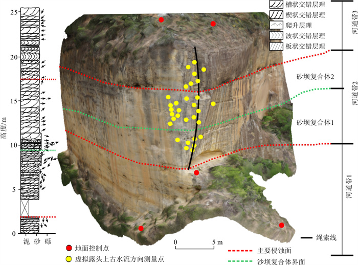
图 6 交错层理砂岩的数字露头模型及基于LIME软件的古水流方向测量[14]
左侧为露头的地层柱状图,黑色箭头为沿绳索线获取的现场古水流测量值
Figure 6. Digital outcrop model of cross-bedded sandstones and paleocurrent measurement using LIME software

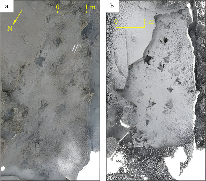
图 7 基于无人机照片生成的恐龙足迹数字正射影像(a)和经环境光遮蔽处理后的影像(b)[15]
Figure 7. Orthophotographs of trackways for dinosaurs generatedusing UAV images (a) and ambient occlusion (b)

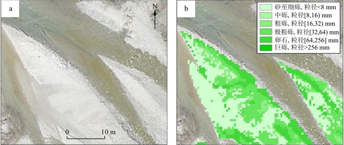
图 8 基于无人机点云的表层沉积物粒度分级[17]
a.法国Vénéon河砾石滩的数字正射影像(像素大小2 cm);b.基于无人机点云粗糙度生成的表层沉积物粒度分级图
Figure 8. Grain size grading based on UAV-based point clouds

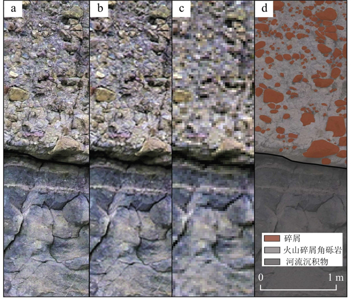
图 9 犹他州Circleville峡谷不同分辨率的粗粒火山碎屑地层数字正射影像[18]
a.7 mm分辨率;b.14 mm分辨率;c.28 mm分辨率;d.基于7 mm数字正射影像得到的数字化碎屑图
Figure 9. Orthophotographs of the coarse-grained volcaniclastic stratigraphy with different resolutions from Circleville Canyon in Utah

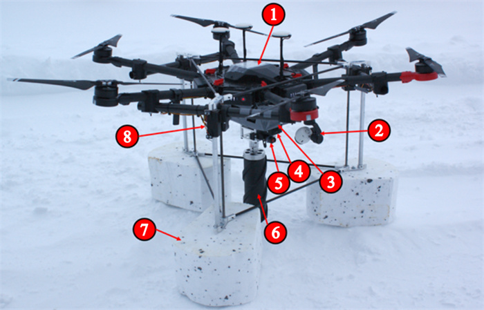
图 10 IseDD无人机的主要部件[20]
1.DJI M600 Pro机身;2.DJI Zenmuse X3机载相机;3.电子设备舱;4.GPS电磁阀释放装置;5.滚动警报LED,用于在钻取过程中警告操作员冰山是否出现滚落;6.冰心钻头;7.紧急水上迫降浮标;8.起落架
Figure 10. Main parts of the ISeDD drone

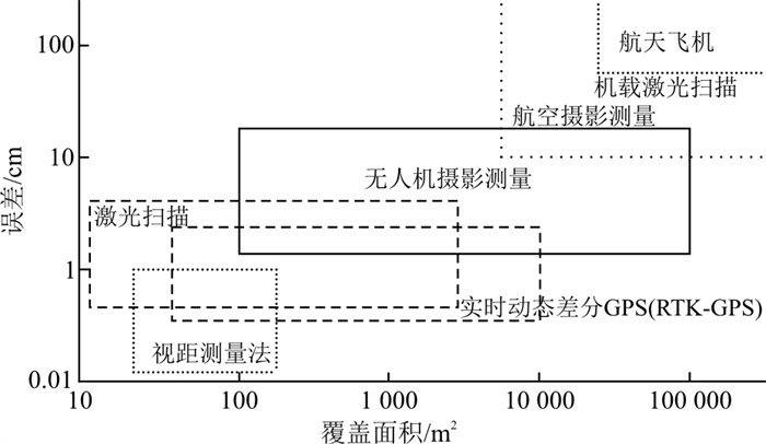
图 11 无人机摄影测量和其他测量技术所覆盖的空间范围及数据误差比较[6]
Figure 11. Comparison of coverage areas and error among UAV photogrammetry and other surveying techniques

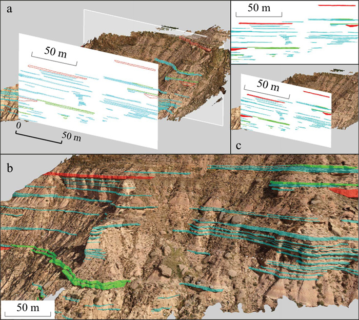
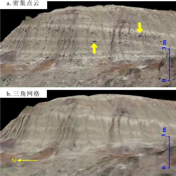
图 12 薄层点沙坝沉积剖面数字露头模型[27]
Figure 12. Digital outcrop model for the profile of thin-bedded point-bar deposits
表 1 无人机数字露头模型在沉积学中的应用范畴[5]
Table 1. Applications of the UAV-derived digital outcrop models in sedimentology
沉积岩层的识别与解释 数字正射影像 DEM 3D纹理网格 岩层的侧向展布范围 常用 常用 较常用 岩层在垂向上的连续性 较常用 常用 较常用 岩层是否遭受侵蚀或被覆盖 较常用 常用 较常用 岩层的大尺度构造变形特征 较常用 常用 岩层(与岩脉等)交切关系 常用 较常用 不同岩层之间的接触关系 常用 较常用 常用 岩相解释 常用 岩层的几何形态(产状特征) 常用 较常用 常用 沉积物粒径大小和磨圆度 常用 野外观测中难以辨认的特征 较常用 常用 适合在GIS中进行量测 常用 常用  下载: 导出CSV
表 2 文中涉及的无人机沉积学应用的硬件和软件平台
Table 2. Hardware and software platforms for applications of the UAV in sedimentology discussed in this paper
无人机沉积学应用 硬件平台 软件平台 资料来源 识别古冲积扇地层 DJI Mavic Air Agisoft Metashape 文献[7] 识别古分流河道体系 DJI Phantom 4Pro AgisoftMetashape 文献[11] 识别潮汐主导的河口湾相沉积 DJI Phantom 4Pro LIME 文献[12] 从交错层理中提取古水流方向 DJI Phantom 4 Pro、X800、3DR Iris Agisoft Metashape、LIME 文献[14] 识别恐龙足迹 DJI T600 Inspire 1 AgisoftMetashape、CloudCompare 文献[15] 量化河流底质粒径大小 Draganflyer X6 AgisoftMetashape、CloudCompare 文献[16] 生成辫状河砾石滩表面沉积物粒度分级图 四旋翼无人机 AgisoftMetashape、CloudCompare 文献[17] 测量粗粒火山碎屑地层粒度 DJI Phantom 4 Agisoft Metashape、Pix4Dmapper、ArcGIS Pro 文献[18] 北极冰芯采样 DJI Matrice 600 Pro / 文献[20]
下载: 导出CSV
表 3 常用于地学领域的无人机平台及相关参数
Table 3. UAV platforms and related parameters commonly used in geoscience
主要飞行参数 DJI Phantom 4 Pro DJI T600 Inspire 1 DJI Mavic Air 2 Draganflyer X6 飞行平台构型 多旋翼(四旋翼) 多旋翼(四旋翼) 多旋翼(四旋翼) 多旋翼(六旋翼) 机身质量(包括电池和浆)/g 1 388 2 845 570 1 645 最大水平飞行速度(运动模式)/(m·s-1) 20 22 19 14 最大垂直飞行速度(运动模式)/(m·s-1) 6(升)、4(降) 5(升)、4(降) 4(升)、3(降) 2(升)、2(降) 单次飞行时间/min 约30 约18 约34 10~15 电池容量及类型 5 870 mAh LiPo 4S 4 500 mAh LiPo 6S 3 500 mAh LiPo 3S 5 400 mAh LiPo 4S 影像传感器 1英寸CMOS有效像素2 000万 X3 FC350相机有效像素1 240万 1/2英寸CMOS有效像素1 200万以及4 800万 1英寸CMOS有效像素1 000万 数据来源:www.dji.com、www.best-quadcopter.com/uncategorized/2021/03/draganflyer-x6-drone-review/
下载: 导出CSV
-
[1] Jordan B R. A bird's-eye view of geology: The use of micro drones/UAVs in geologic fieldwork and education[J]. GSA Today, 2015, 25(7): 50-52. [2] Pavlis T L, Mason K A. The new world of 3D geologic mapping[J]. GSA Today, 2017, 27(9): 4-10. [3] Gonzaga L, Veronez M R, Alves D N, et al. MOSIS—Multi-outcrop sharing & interpretation system[C]//Anon. 2017 IEEE International Geoscience and Remote Sensing Symposium (IGARSS). Fort Worth, TX: IEEE, 2017: 5209-5212. [4] Bellian J A, Kerans C, Jennette D C. Digital outcrop models: Applications of terrestrial scanning lidar technology in stratigraphic modeling[J]. Journal of Sedimentary Research, 2005, 75(2): 166-176. doi: 10.2110/jsr.2005.013 [5] Harrald J E G, Coe A L, Thomas R M, et al. Use of drones to analyse sedimentary successions exposed in the foreshore[J]. Proceedings of the Geologists' Association, 2021, 132(3): 253-268. doi: 10.1016/j.pgeola.2021.02.001 [6] Siebert S, Teizer J. Mobile 3D mapping for surveying earthwork projects using an Unmanned Aerial Vehicle (UAV) system[J]. Automation in Construction, 2014, 41: 1-14. doi: 10.1016/j.autcon.2014.01.004 [7] Meek S R, Carrapa B, DeCelles P G. Recognizing allogenic controls on the stratigraphic architecture of ancient alluvial fans in the western US[J]. Frontiers in Earth Science, 2020, 8: 215. doi: 10.3389/feart.2020.00215 [8] 高莎, 袁希平, 甘淑, 等. 基于无人机成像点云的禄丰恐龙谷南缘环状地貌空间特征探测实验分析[J]. 地质科技通报, 2021, 40(6): 283-292. doi: 10.19509/j.cnki.dzkq.2021.0628Gao S, Yuan X P, Gan S, et al. Experimental analysis of spatial feature detection of the ring geomorphology at the south edge of Lufeng Dinosaur Valley based on UAV imaging point cloud[J]. Bulletin of Geological Science and Technology, 2021, 40(6): 283-292(in Chinese with English abstract). doi: 10.19509/j.cnki.dzkq.2021.0628 [9] Corradetti A, Tavani S, Parente M, et al. Distribution and arrest of vertical through-going joints in a seismic-scale carbonate platform exposure (Sorrento peninsula, Italy): Insights from integrating field survey and digital outcrop model[J]. Journal of Structural Geology, 2018, 108: 121-136. doi: 10.1016/j.jsg.2017.09.009 [10] 孙姣姣, 王琦, 郑洁, 等. 基于DOM成果的航测软件对比分析[J]. 测绘与空间地理信息, 2021, 44(8): 71-74. https://www.cnki.com.cn/Article/CJFDTOTAL-DBCH202108017.htmSun J J, Wang Q, Zheng J, et al. Comparative analysis of aerial survey software based on DOM results[J]. Geomatics & Spatial Information Technology, 2021, 44(8): 71-74(in Chinese with English abstract). https://www.cnki.com.cn/Article/CJFDTOTAL-DBCH202108017.htm [11] Aliyuda K, Howell J, Usman M B, et al. Depositional variability of an ancient distributive fluvial system: The upper member of the Lower Cretaceous Bima Formation, northern Benue Trough, Nigeria[J]. Journal of African Earth Sciences, 2019, 159: 103600. doi: 10.1016/j.jafrearsci.2019.103600 [12] Phillips S P, Howell J A, Hartley A J, et al. Tidal estuarine deposits of the transgressive Naturita Formation (Dakota Sandstone): San Rafael Swell, Utah, U.S.A. [J]. Journal of Sedimentary Research, 2020, 90(8): 777-795. doi: 10.2110/jsr.2020.51 [13] Buckley S J, Ringdal K, Naumann N, et al. LIME: Software for 3-D visualization, interpretation, and communication of virtual geoscience models[J]. Geosphere, 2019, 15(1): 222-235. doi: 10.1130/GES02002.1 [14] Freitas B T, Silva L H G, Almeida R P, et al. Cross‐strata palaeocurrent analysis using virtual outcrops[J]. Sedimentology, 2021, 68(6): 2397-2421. doi: 10.1111/sed.12855 [15] Romilio A, Hacker J M, Zlot R, et al. A multidisciplinary approach to digital mapping of dinosaurian tracksites in the Lower Cretaceous (Valanginian-Barremian) Broome Sandstone of the Dampier Peninsula, western Australia[J]. Peer J, 2017, 5: e3013. doi: 10.7717/peerj.3013 [16] Woodget A S, Austrums R. Subaerial gravel size measurement using topographic data derived from a UAV-SfM approach: Subaerial gravel size measurement using topographic UAV-SfM data[J]. Earth Surface Processes and Landforms, 2017, 42(9): 1434-1443. doi: 10.1002/esp.4139 [17] Vázquez-Tarrío D, Borgniet L, Liébault F, et al. Using UAS optical imagery and SfM photogrammetry to characterize the surface grain size of gravel bars in a braided river (Vénéon River, French Alps)[J]. Geomorphology, 2017, 285: 94-105. doi: 10.1016/j.geomorph.2017.01.039 [18] Smith Z D, Maxwell D J. Constructing vertical measurement logs using UAV-Based photogrammetry: Applications for multiscale high-resolution analysis of coarse-grained volcaniclastic stratigraphy[J]. Journal of Volcanology and Geothermal Research, 2021, 409: 107122. doi: 10.1016/j.jvolgeores.2020.107122 [19] Mori T, Hashimoto T, Terada A, et al. Volcanic plume measurements using a UAV for the 2014 Mt. Ontake eruption[J]. Earth, Planets and Space, 2016, 68(1): 1-18. doi: 10.1186/s40623-015-0369-x [20] Carlson D F, Pasma J, Jacobsen M E, et al. Retrieval of ice samples using the ice drone[J]. Frontiers in Earth Science, 2019, 7: 287. doi: 10.3389/feart.2019.00287 [21] Bemis S P, Micklethwaite S, Turner D, et al. Ground-based and UAV-based photogrammetry: A multi-scale, high-resolution mapping tool for structural geology and paleoseismology[J]. Journal of Structural Geology, 2014, 69: 163-178. doi: 10.1016/j.jsg.2014.10.007 [22] 周银邦, 赵淑霞, 张庆新, 等. 露头类比方法在地下储层建模中的应用进展[J]. 地质科技情报, 2017, 36(1): 247-254. https://www.cnki.com.cn/Article/CJFDTOTAL-DZKQ201701033.htmZhou Y B, Zhao S X, Zhang Q X, et al. Progress of the outcrop analogy method application in the modeling of underground reservoirs[J]. Geological Science and Technology Information, 2017, 36(1): 247-254(in Chinese with English abstract). https://www.cnki.com.cn/Article/CJFDTOTAL-DZKQ201701033.htm [23] Pitman S J, Hart D E, Katurji M H. Application of UAV techniques to expand beach research possibilities: A case study of coarse clastic beach cusps[J]. Continental Shelf Research, 2019, 184: 44-53. doi: 10.1016/j.csr.2019.07.008 [24] 万剑华, 王朝, 刘善伟, 等. 倾斜摄影测量构建地质数字露头[J]. 地质科技情报, 2019, 38(1): 258-264. https://www.cnki.com.cn/Article/CJFDTOTAL-DZKQ201901029.htmWan J H, Wang C, Liu S W, et al. Reconstructing geological digital outcrops with oblique photogrammetry[J]. Geological Science and Technology Information, 2019, 38(1): 258-264(in Chinese with English abstract). https://www.cnki.com.cn/Article/CJFDTOTAL-DZKQ201901029.htm [25] 吕权儒, 曾斌, 孟小军, 等. 基于无人机倾斜摄影技术的崩塌隐患早期识别及影响区划分方法[J]. 地质科技通报, 2021, 40(6): 313-325. doi: 10.19509/j.cnki.dzkq.2021.0631Lü Q R, Zeng B, Meng X J, et al. Early identification and influence range division method of collapse hazards based on UAV oblique photography technology[J]. Bulletin of Geological Science and Technology, 2021, 40(6): 313-325(in Chinese with English abstract). doi: 10.19509/j.cnki.dzkq.2021.0631 [26] Mezghani M M, Fallatah M I, AbuBshait A A. From drone-based remote sensing to digital outcrop modeling: Integrated workflow for quantitative outcrop interpretation[J]. Journal of Remote Sensing & GIS, 2018, 7(2): 1-7. [27] Nesbit P R, Durkin P R, Hugenholtz C H, et al. 3-D stratigraphic mapping using a digital outcrop model derived from UAV images and structure-from-motion photogrammetry[J]. Geosphere, 2018, 14(6): 2469-2486. [28] Liao Y, Mohammadi M E, Wood R L. Deep learning classification of 2D orthomosaic images and 3D point clouds for post-event structural damage assessment[J]. Drones, 2020, 4(2): 24. [29] Khan A I, Al-Mulla Y. Unmanned aerial vehicle in the machine learning environment[J]. Procedia Computer Science, 2019, 160: 46-53. [30] Singh K K, Frazier A E. A meta-analysis and review of unmanned aircraft system (UAS) imagery for terrestrial applications[J]. International Journal of Remote Sensing, 2018, 39(15/16): 5078-5098. [31] James M R, Chandler J H, Eltner A, et al. Guidelines on the use of structure‐from‐motion photogrammetry in geomorphic research[J]. Earth Surface Processes and Landforms, 2019, 44(10): 2081-2084. -

 下载:
下载:

 点击查看大图
计量
- 文章访问数: 785
- PDF下载量: 108
- 被引次数: 0

