


Application and development trend of geostatistics in the research of spatial variation of aquifer parameters
-
摘要: 科学合理评价地下水资源,对统筹规划、合理开发利用区域地下水,保障区域生态环境安全至关重要。获取含水层参数空间变异规律是解决地下水渗流、污染物运移、地下水开发利用等诸多地下水问题的重要基础。然而,受常规勘察技术所限,含水层非均质性难以直接刻画。两点地质统计学通过变异函数确定随机变量相关关系,解决地质变量空间线性估计并表征其各向异性;多点地质统计学突破了空间两点间相关关系的局限,通过多点训练图像建模,有效反映含水层参数变量空间分布特征,也更适合模拟复杂结构地质体。据此,本文对常用的两点地质统计学在含水层参数空间变异研究中的实际应用作了简述和探讨,并以含水层渗透系数为媒介,阐述了岩土电阻率和水力梯度或水头与渗透系数在地质统计学中运用的限制性协同关系。应用对比了多点地质统计建模与传统地质统计建模相比所具有的优势,并探讨了后者受自身算法、建模方法等制约现如今仍然尚未解决的问题及未来发展方向。指出在卫星、雷达及遥感技术快速发展背景下,数据同化、机器学习等手段融合、集成和尺度推绎多源、多空间、多分辨率空间数据帮助地质统计学实现数值建模是大势所趋。Abstract: Scientific and reasonable evaluation of groundwater resources is essential for overall planning, rational development and utilization of regional groundwater, and ensuring the safety of regional ecological environment.Obtaining spatial heterogeneous distribution information of aquifer characteristics is a critical first step in resolving a variety of groundwater issues, such as seepage, pollution transport, groundwater development and exploitation.The heterogeneity of aquifers, however, is difficult to properly define due to the limitations of traditional survey equipment.Two-point geostatistics determines the correlation of random variables through variogram, solves the spatial linear estimation of geological variables and characterizes their anisotropy.Multi-point geostatistics breaks through the limitation of spatial correlation between two points, and effectively reflects the spatial distribution characteristics of aquifer parameters through multi-point training image modeling, which is also more suitable for simulating complex geological bodies.Based on this, the paper briefly describes and discusses the commonly used two-point geostatistics in the assessment of the spatial variation of aquifer parameters.Furthermore, the hydraulic conductivity is utilized as a medium to summarize the restricted synergistic relationships between hydraulic conductivity and electrical resistivity, hydraulic gradient or hydraulic head in two-point geostatistics.Besides, the advantages of multi-point geostatistical modeling are summarized after being compared with traditional geostatistical modeling.The unsolved problems and future development direction by its own algorithms and modeling methods are also discussed.Meanwhile, it is also pointed out that under the background of the rapid development of satellite, radar and remote sensing technology, the arrival of geological big data era shows a general trend that multi-source, multi-spatial and multi-resolution spatial data can be integrated and scale-driven by data assimilation, machine learning and other methods to help geostatistics achieve numerical modeling.
-
Key words:
- aquifer parameters /
- geostatistics /
- spatial variability /
- geological big data
-

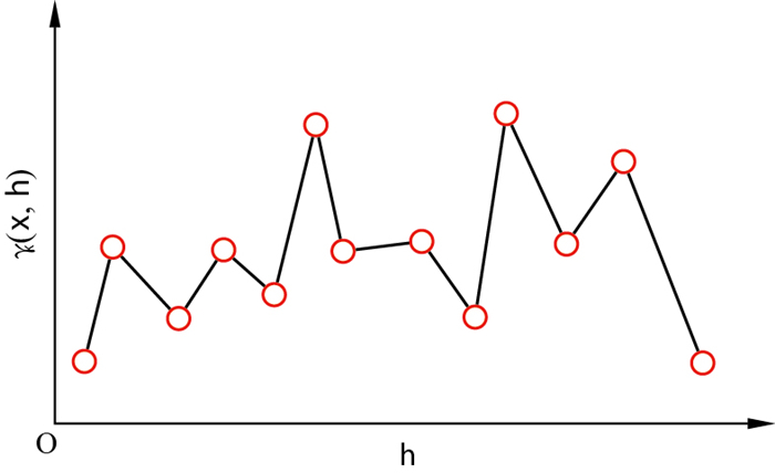
图 1 特异值出现的变异函数
γK(x, h)为区域化变量K(x)在x方向上的变异函数
Figure 1. Graph of variogram with singular values

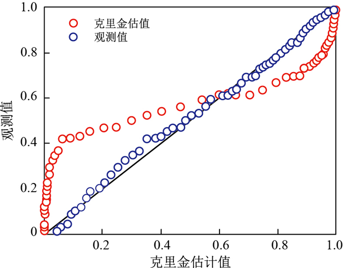
图 2 OK法估值与观测值对比分析(据文献[63]修改)
Figure 2. Comparative and analysis of valuation and observed values with OK method

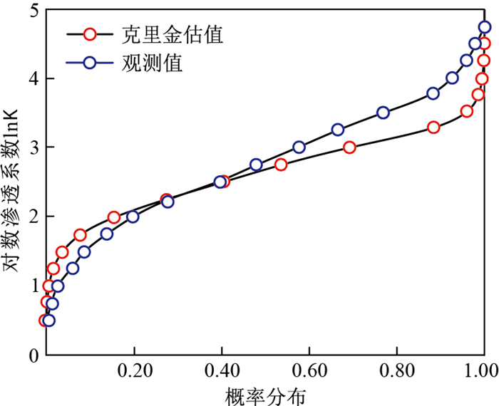
图 3 对数渗透系数OK法估值效果与观测数据累计概率分布曲线对比[64]
Figure 3. Comparison of curves of the cumalative probability distribution of valuation and observed values with logarithm permeability coefficient OK method

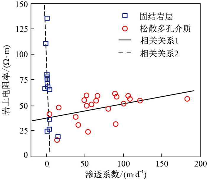
图 4 岩土电阻率和含水层渗透系数关系(据文献[77]修改)
Figure 4. Relationship between rock resistivity and aquifer hydraulic conductivity

图 6 不同岩性渗透系数K与水力梯度I关系曲线[83]
Figure 6. Relationship between permeability coefficient (K) and hydraulic gradient (I) of different lithologies
-
[1] 施小清, 吴吉春, 袁永生, 等. 渗透系数空间变异性研究[J]. 水科学进展, 2005, 16(2): 210-215. doi: 10.3321/j.issn:1001-6791.2005.02.010Shi X Q, Wu J C, Yuan Y S, et al. Study on spatial variability of permeability coefficient[J]. Progress in Water Science, 2005, 16(2): 210-215(in Chinese with English abstract). doi: 10.3321/j.issn:1001-6791.2005.02.010 [2] Freeze R A. A stochastic-conceptual analysis of one-dimensional groundwater flow in nonuniform homogeneous media[J]. Water Resources Research, 1975, 11(5): 725-741. doi: 10.1029/WR011i005p00725 [3] 苗添升, 卢文喜, 欧阳琦, 等. 地下水数值模拟的不确定性分析在水质预测中的应用[J]. 水电能源科学, 2016, 8: 20-23, 44. https://www.cnki.com.cn/Article/CJFDTOTAL-SDNY201608005.htmMiao T S, Lu W X, Ouyang Q, et al. Application of uncertainty analysis of groundwater numerical simulation in water quality prediction[J]. Water Resources and Power, 2016, 8: 20-23, 44(in Chinese with English abstract). https://www.cnki.com.cn/Article/CJFDTOTAL-SDNY201608005.htm [4] 彭伏, 常勇, 郑秀清, 等. 地下水模型参数不确定性对晋祠泉流量预测的影响[J]. 水电能源科学, 2018, 10: 53-57. https://www.cnki.com.cn/Article/CJFDTOTAL-SDNY201810013.htmPeng F, Chang Y, Zheng X Q, et al. Influence of uncertainty of groundwater model parameters on flow prediction of Jinci Spring[J]. Water Resources and Power, 2018, 10: 53-57(in Chinese with English abstract). https://www.cnki.com.cn/Article/CJFDTOTAL-SDNY201810013.htm [5] Ritzi R W, Dai Z, Dominic D F, et al. Spatial correlation of permeability in cross-stratified sediment with hierarchical architecture[J]. Water Resources Research, 2004, 40: W03513. [6] Neuman S P. Blueprint for perturbative solution of flow and transport in strongly heterogeneous composite media, using fractal and variational multiscale decomposition[J]. Water Resources Research, 2006, 42: W06D04. [7] 杰夫·卡尔斯, 陈军斌, 程国建, 等. 石油地质统计学[M]. 北京: 石油工业出版社, 2014.Karls J, Chen J B, Cheng G J, et al. Petroleum geostatistics[M]. Beijing: Petroleum Industry Press, 2014(in Chinese). [8] 杰夫·卡尔斯, 程国建, 李小和, 等. 地球科学中的不确定性建模[M]. 北京: 石油工业出版社, 2016.Karls J, Cheng G J, Li X H, et al. Uncertainty modeling in earth sciences[M]. Beijing: Petroleum Industry Press, 2016(in Chinese). [9] Matheron G. Traitéde géostatistique appliquée[M]. Paris: Editions Technip, 1962. [10] Krige D G. A statistical approach to some basic mine valuation problems on the Witwatersrand[J]. Journal of the Southern African Institute of Mining and Metallurgy, 1951, 52(6): 119-139. [11] Matheron G. Principles of geostatistics[J]. Economic Geology, 1963, 58(8): 1246-1266. doi: 10.2113/gsecongeo.58.8.1246 [12] Journel A G, Huijbregts C J. Mining geostatistics[M]. London: Academic Press, 1978. [13] Matheron G. The theory of regionalized variables and its application[M]. [S. l.]: Les Cahiers Du Center De Morphologie Mathématique De Fontainebleau, 1971. [14] Matheron G. Le krigeage universe[M]. Paris: École Nationale Supérieure des Mines de Paris, 1969. [15] Verly G, David M, Journel A G, et al. Geostatistics for natural resources characterization[M]. Dordrecht: D. Reidel Publishing Company, 1984. [16] Journel A G. Nonparametric estimation of spatial distributions[J]. Journal of the International Association for Mathematicl Geology, 1983, 15(3): 445-468. doi: 10.1007/BF01031292 [17] Matheron G. Recherche de simplification dans un problème de cokrigeage[M]. Punblication N-628. Fontainableau: Centre de Géostatistique, Ecole des Mines de Paris, 1979. [18] Matheron G. Pourune analyse krigeante des données régionalisées[M]. [S. l.]: Centre de Geostatistique, Report N-732, Fontainebleau, 1982. [19] Remy N, Boucher A, Wu J. Applied geostatistics with SGeMS: A user's guide[M]. Cambridge: Cambridge University Press, 2009. [20] Soares A. Geostatistics Tróia '92[M]. Dordrecht: Kluwer Academic Publishers, 1993. [21] Strebelle S B. Sequential simulation drawing structures from training images[D]. State of California: Stanford University, 2000. [22] Strebelle S B, Journel A G. Reservoir modeling using multiple-point statistics[C]//Anon. SPE Annual Technical Conference and Exhibition, New Orleans, Louisiana, 2001. [S. l.]: [s. n.], 2001. [23] Shirangi M G. Closed-loop field development with multipoint geostatistics and statistical performance assessment[J]. Journal of Computational Physics, 2019, 390(1): 249-264. [24] Goovaerts P. Geostatistics for natural resources evaluation[M]. Oxford: Oxford University Press, 1997. [25] Journel A, Isaaks E. Conditional indicator simulation: Application to a Saskatchewan uranium deposit[J]. Journal of the International Association for Mathematical Geology, 1984, 16(7): 685-718. doi: 10.1007/BF01033030 [26] Scheidt C, Li L, Caers J. Quantifying uncertainty in subsurface systems[M]. New York: American Geophysical Union and John Wiley & Sons, Inc., 2018. [27] 刘晓晨, 陆永潮, 杜学斌, 等. 层序格架约束下的地质统计学反演在薄砂体预测中的应用[J]. 地质科技通报, 2020, 39(3): 99-109. doi: 10.19509/j.cnki.dzkq.2020.0311Liu X C, Lu Y C, Du X B, et al. Application of geostatistical inversion constrained by sequence framework in thin bedded sand body prediction[J]. Bulletin of Geological Science and Technology, 2020, 39(3): 99-109(in Chinese with English abstract). doi: 10.19509/j.cnki.dzkq.2020.0311 [28] Chen X H, Song J X, Wang W K, et al. Spatial variability of specific yield and vertical hydraulic conductivity in a highly permeable alluvial aquifer[J]. Journal of Hydrology, 2010, 388: 379-388. doi: 10.1016/j.jhydrol.2010.05.017 [29] Wang W, Wang Y, Sun Q M, et al. Spatial variation of saturated hydraulic conductivity of a loess slope in the South Jingyang Plateau, China[J]. Engineering Geology, 2018, 236(6): 70-78. [30] Godoy V A, Zuquette L V, Gómez-Hernández J. Spatial variability of hydraulic conductivity and solute transport parameters and their spatial correlations to soil properties[J]. Geoderma, 2019, 339(1): 59-69. [31] Christine E H, Andrew T F, Chris R R, et al. Spatial and temporal variations in streambed hydraulic conductivity quantified with time series thermal methods[J]. Journal of Hydrology, 2010, 389: 276-288. doi: 10.1016/j.jhydrol.2010.05.046 [32] Dewandel B, Jeanpert J, Ladouche B, et al. Inferring the heterogeneity, transmissivity and hydraulic conductivity of crystalline aquifers from a detailed water-table map[J]. Journal of Hydrology, 2017, 550: 118-129. doi: 10.1016/j.jhydrol.2017.03.075 [33] Benoit S, Ghysels G, Gommers K, et al. Characterization of spatially variable riverbed hydraulic conductivity using electrical resistivity tomography and induced polarization[J]. Hydrogeology Journal, 2019, 27: 395-407. doi: 10.1007/s10040-018-1862-7 [34] Schilling O S, James Irvine D, Franssen H J H, et al. Estimating the spatial extent of unsaturated zones in heterogeneous river aquifer systems[J]. Water Resources Research, 2017, 53(10): 583-602. [35] Berton G. Comparison between two interpolation methods: Kriging and EPH[J]. International Conference on Mathematical Modelling in Physical Sciences, 2018, 1141(1): 27-31. [36] Mishra P N, Scheuermann A, Li L. Evaluation of hydraulic conductivity functions of saturated soft soils[J]. International Journal of Geomechanics, 2020, 20(11): 04020214. doi: 10.1061/(ASCE)GM.1943-5622.0001847 [37] 唐攀, 唐菊兴, 林彬, 等. 传统几何法与地质统计学法在矿产资源储量估算中的对比分析[J]. 地质科技情报, 2016, 35(1): 156-160. https://www.cnki.com.cn/Article/CJFDTOTAL-DZKQ201601024.htmTang P, Tang J X, Lin B, et al. Comparative research of traditional method and geostatistical in mineral resource/reserve calculation[J]. Geological Science and Technology Information, 2016, 35(1): 156-160(in Chinese with English abstract). https://www.cnki.com.cn/Article/CJFDTOTAL-DZKQ201601024.htm [38] Xue P P, Wen Z, Zhao D J, et al. Determination of hydraulic conductivity and its spatial variability in the Jianghan Plain using a multi-format, multi-method approach[J]. Journal of Hydrology, 2021, 594: 125917. doi: 10.1016/j.jhydrol.2020.125917 [39] Journel A G, Huijbregts C J. Mining geostatistics[M]. New York: Academic Press, 1978. [40] 杨江州, 周旭, 程东亚, 等. 贵州省不同地貌类型区的MOD16蒸散发变化特征[J]. 水土保持研究, 2019, 26(2): 216-222. https://www.cnki.com.cn/Article/CJFDTOTAL-STBY201902034.htmYang J Z, Zhou X, Cheng D Y, et al. Variation characteristics of MOD16 evapotranspiration in different geomorphic areas of Guizhou Province[J]. Study on Soil and Water Conservation, 2019, 26(2): 216-222(in Chinese with English abstract). https://www.cnki.com.cn/Article/CJFDTOTAL-STBY201902034.htm [41] Shukla K, Kumar P S, Mann G, et al. Mapping spatial distribution of particulate matter using Kriging and inverse distance weighting at supersites of megacity Delhi[J]. Sustainable Cities and Society, 2020, 54: 101997. doi: 10.1016/j.scs.2019.101997 [42] Sagar B S D, Cheng Q M, Agterberg F. Handbook of mathematical geosciences: Fifty years of IAMG[M]. Cham: Springer International Publishing AG, 2018. [43] Pham T G, Kappas M, Huynh C V, et al. Application of ordinary Kriging and regression Kriging method for soil properties mapping in hilly region of Central Vietnam[J]. ISPRS Int. J. Geo-Inf., 2019, 8(3): 147. doi: 10.3390/ijgi8030147 [44] Zhu Q, Lin H S. Comparing ordinary Kriging and regression Kriging for soil properties in contrasting landscapes[J]. Pedosphere, 2010, 20(5): 594-606. doi: 10.1016/S1002-0160(10)60049-5 [45] Moustapha M, Bourinet J M, Guillaume B, et al. Comparative study of Kriging and support vector regression for structural engineering applications[J]. ASCE-ASME Journal of Risk and Uncertainty in Engineering Systems, Part A: Civil Engineering, 2018, 4(2): 04018005. doi: 10.1061/AJRUA6.0000950 [46] 徐谢亲, 祝明霞. 基于GIS的江西省气温空间插值方法比较[J]. 绿色科技, 2021, 23(10): 21-24. doi: 10.3969/j.issn.1674-9944.2021.10.007Xu X Q, Zhu M X. Comparison of spatial interpolation methods of air temperature in Jiangxi Province based on GIS[J]. Green Science and Technology, 2021, 23(10): 21-24(in Chinese with English abstract). doi: 10.3969/j.issn.1674-9944.2021.10.007 [47] Echard B, Gayton N, Lemaire M. AK-MCS: An active learning reliability method combining Kriging and Monte Carlo simulation[J]. Structural Safety, 2011, 33(2): 145-154. doi: 10.1016/j.strusafe.2011.01.002 [48] 贺辰戋, 欧阳婷萍, 彭莎莎. 广州市表层土壤磁学性质的空间插值方法比较[J]. 热带地理, 2020, 40(5): 904-918. https://www.cnki.com.cn/Article/CJFDTOTAL-RDDD202005013.htmHe C J, Ouyang T P, Peng S S. Comparison of spatial interpolation methods for magnetic properties of topsoil in Guangzhou[J]. Tropical Geography, 2020, 40(5): 904-918(in Chinese with English abstract). https://www.cnki.com.cn/Article/CJFDTOTAL-RDDD202005013.htm [49] 王伟, 宋渊娟, 黄静, 等. 利用高压压汞实验研究致密砂岩孔喉结构分形特征[J]. 地质科技通报, 2021, 40(4): 22-30, 48. doi: 10.19509/j.cnki.dzkq.2021.0402Wang W, Song Y J, Huang J, et al. Study on fractal characteristics of pore throat structure of tight sandstone by high pressure mercury injection experiment[J]. Bulletin of Geological Science and Technology, 2021, 40(4): 22-30, 48(in Chinese with English abstract). doi: 10.19509/j.cnki.dzkq.2021.0402 [50] Illman W A, Zhu J, Craig A J, et al. Comparison of aquifer characterization approaches through steady state groundwater model validation: A controlled laboratory sandbox study[J]. Water Resources Research, 2010, 46(4): 475-478. [51] Arslan H. Spatial and temporal mapping of groundwater salinity using ordinary Kriging and indicator Kriging: The case of Bafra Plain, Turkey[J]. Agricultural Water Management, 2012, 113: 57-63. doi: 10.1016/j.agwat.2012.06.015 [52] Delbari M, Amiri M, Motlagh M B, et al. Assessing groundwater quality for irrigation using indicator Kriging method[J]. Appl. Water Sci., 2016, 6: 371-381. [53] Lee S Y, Carle S F, Fogg G E, et al. Geologic heterogeneity and a comparison of two geostatistical models: Sequential Gaussian and transition probability-based geostatistical simulation[J]. Advances in Water Resources, 2007, 30: 1914-1932. doi: 10.1016/j.advwatres.2007.03.005 [54] Piccini C, Marchetti A, Farina R, et al. Application of indicator Kriging to evaluate the probability of exceeding nitrate contamination thresholds[J]. International Journal of Environmental Research, 2012, 6(4): 853-862. [55] Bradaï A, Douaoui A, Bettahar N, et al. Improving the prediction accuracy of groundwater salinity mapping using indicator Kriging method[J]. Journal of Irrigation and Drainage Engineering, 2016, 142(7): 04016023. doi: 10.1061/(ASCE)IR.1943-4774.0001019 [56] 徐英, 葛洲, 王娟, 等. 基于指示Kriging法的土壤盐渍化与地下水埋深关系研究[J]. 农业工程学报, 2019(1): 123-130. https://www.cnki.com.cn/Article/CJFDTOTAL-NYGU201901016.htmXu Y, Ge Z, Wang J, et al. Study on the relationship between soil salinization and groundwater depth based on indicator Kriging method[J]. Journal of Agricultural Engineering, 2019, (1): 123-130(in Chinese with English abstract). https://www.cnki.com.cn/Article/CJFDTOTAL-NYGU201901016.htm [57] Adhikary P P, Dash C J, Bej R, et al, Chandrasekharan H. Indicator and probability Kriging methods for delineating Cu, Fe, and Mn contamination in groundwater of Najafgarh Block, Delhi, India[J]. Environmental Monitoring and Assessment, 2011, 176: 663-676. doi: 10.1007/s10661-010-1611-4 [58] Gratiet L L, Garnier J. Recursive co-Kriging model for design of computer experiments with multiple levels of fidelity[J]. International Journal for Uncertainty Quantification, 2014, 4(5): 365-386. doi: 10.1615/Int.J.UncertaintyQuantification.2014006914 [59] Kanankege K S T, Alkhamis M A, Pheeps N B D, et al. A probability co-Kriging model to account for reporting Bias and recognize areas at high risk for Zera Mussels and Eurasian watermilfoil invasions in Minnesota[J]. Front. Vet. Sci., 2018, 4: 231. doi: 10.3389/fvets.2017.00231 [60] Mendes M P, Ribeiro L. Nitrate probability mapping in the northern aquifer alluvial system of the river Tagus(Portugal) using disjunctive Kriging[J]. Science of the Total Environment, 2010, 408(5): 1021-1034. doi: 10.1016/j.scitotenv.2009.10.069 [61] 吴双红, 刘泉, 戚俊杰, 等. 基于水力走时反演刻画裂隙含水层非均质性[J]. 地质科技通报, 2021, 40(1): 175-183. doi: 10.19509/j.cnki.dzkq.2021.0015Wu S H, Li Q, Qi J J, et al. Depicting the heterogeneity of fractured aquifer based on hydraulic travel time inversion[J]. Bulletin of Geological Science and Technology, 2021, 40(1): 175-183(in Chinese with English abstract). doi: 10.19509/j.cnki.dzkq.2021.0015 [62] Asa E, Saafi M, Membah J, et al. Comparison of linear and nonlinear Kriging methods for characterization and interpolation of soil data[J]. Journal of Computing in Civil Engineering, 2012, 26(1): 11-18. doi: 10.1061/(ASCE)CP.1943-5487.0000118 [63] Yamamoto J K. Correcting the smoothing effect of ordinary Kriging estimates[J]. Mathematical Geology, 2005, 37(1): 69-94. doi: 10.1007/s11004-005-8748-7 [64] 施小清, 姜蓓蕾, 卞锦宇, 等. 以地质统计方法推估上海第三承压含水层渗透系数的分布[J]. 工程勘察, 2009, 1: 36-41. https://www.cnki.com.cn/Article/CJFDTOTAL-GCKC200901011.htmShi X Q, Jiang B L, Bian J Y, et al. Geostatistical analysis for estimating the spatial variability of hydraulic conductivity in the third confined aquifer of Shanghai City[J]. Geotechnical Investigation & Surveying, 2009, 1: 36-41(in Chinese with English abstract). https://www.cnki.com.cn/Article/CJFDTOTAL-GCKC200901011.htm [65] Ochie K I, Rotimi O J. Geostatistics-Kriging and co-Kriging methods in reservoir characterization of hydrocarbon rock deposits[J]. SPE Nigeria Annual International Conference and Exhibition, 2018, 8: SPE-193483-MS. [66] Wang L Q, Dai L J, Li L J, et al. Multivariable coKriging prediction and source analysis of potentially toxic elements(Cr, Cu, Cd, Pb, and Zn) in surface sediments from Dongting Lake, China[J]. Ecological Indicators, 2018, 94(1): 312-319. [67] Giraldo R, Herrera L, Leiva V. CoKriging prediction using as secondary variable a functional random field with application in environmental pollution[J]. Mathematics, 2020, 8(8): 1305. doi: 10.3390/math8081305 [68] Kontoudis G P, Stilwell D J. A Comparison of Kriging and coKriging for estimation of underwater acoustic communication performance[J]. Proceedings of the International Conference on Underwater Networks & Systems, 2019, 29: 1-8. [69] Rostami A A, Karimi V, Khatibi R, et al. An investigation into seasonal variations of groundwater nitrate by spatial modelling strategies at two levels by Kriging and co-Kriging models[J]. Journal of Environmental Management, 2020, 270(15): 110843. [70] Archie G E. The electrical resistivity log as an aid in determining some reservoir characteristics[J]. Petroleum Reservoir Simulation, 1942, 146(1): 54-62. [71] Purvance D T, Andricevic R. On electrical hydraulic conductivity correlation in aquifers[J]. Water Resources Research, 2000, 36(10): 2905-2913. doi: 10.1029/2000WR900165 [72] Yeboah-Forson A, Whitman D. Electrical resistivity characterization of anisotropy in the biscayne aquifer[J]. Groundwater, 2014, 52(5): 728-736. doi: 10.1111/gwat.12107 [73] Etete B I, Noiki F R, Aizebeokhai A P, et al. Estimation of hydraulic parameters from vertical electrical resistivity sounding[J]. Journal of Informatics and Mathematical Sciences, 2017, 9(2): 285-296. [74] Mawer C, Parsekian A, Pidlisecky A, et al. Characterizing heterogeneity in infiltration rates during managed aquifer recharge[J]. Groundwater, 2016, 54(6): 818-829. doi: 10.1111/gwat.12423 [75] Marsan D, Azimmah A, Adli D P, et al. Aquifer characterization using 2D electrical resistivity imaging in Kidangpananjung, Cililin District, West Java[J]. Earth and Environmental Science, 2017, 62: 012014. [76] Almadani S, Ibrahim E, Al-Amri A, et al. Delineation of a fractured granite aquifer in the Alwadeen area, Southwest Saudi Arabia using a geoelectrical resistivity survey[J]. Arabian Journal of Geosciences, 2019, 12: 449. doi: 10.1007/s12517-019-4646-z [77] Idrysy E I, Smedt F D. A comparative study of hydraulic conductivity estimations using geostatistics[J]. Hydrogeology Journal, 2007, 15: 459-470. doi: 10.1007/s10040-007-0166-0 [78] Kitanidis P K. Quasi-linear geostatistical theory for inversing[J]. Water Resources Research, 1995, 31(10): 2411-2419. doi: 10.1029/95WR01945 [79] Yeh T C J, Zhang J Q. A geostatistical inverse method for variably saturated flow in the vadose zone[J]. Water Resources Research, 1996, 32(9): 2757-2766. doi: 10.1029/96WR01497 [80] Bailey R, Baù D. Ensemble smoother assimilation of hydraulic head and return flow data to estimate hydraulic conductivity distribution[J]. Water Resources Research, 2010, 46(12): W12543. [81] Jiang L, Bai L, Zhao Y, et al. Combining InSAR and hydraulic head measurements to estimate aquifer parameters and storage variations of confined aquifer system in Cangzhou, North China Plain[J]. Water Resources Research, 2018, 54(10): 8234-8252. doi: 10.1029/2017WR022126 [82] Yoon G L, Cho H Y, Kim Y S, et al. Hydraulic gradient reduction effects on sand-water mixture flows caused by electro-magnetic force generation[J]. Journal of Coastal Research, 2018, 85: 1141-1145. doi: 10.2112/SI85-229.1 [83] 王福刚, 张佳慧, 于吉洋, 等. 不同水力梯度对渗透系数影响研究[J]. 实验技术与管理, 2015, 32(6): 25-28. doi: 10.3969/j.issn.1002-4956.2015.06.008Wang F G, Zhang J H, Yu J Y, et al. Research on influence of different hydraulic gradient on hydraulic conductivity[J]. Experimental Technology and Mangement, 2015, 32(6): 25-28(in Chinese with English abstract). doi: 10.3969/j.issn.1002-4956.2015.06.008 [84] Almeida J A. Stochastic simulation methods for characterization of lithoclasses in carbonate reservoirs[J]. Earth Sci. Rev., 2010, 101: 250-270. doi: 10.1016/j.earscirev.2010.05.002 [85] Hoffman Z R, Kivanc K, DiMarzio C A. Single image structured illumination(SISIM) for in vivo imaging[C]//Three-dimensional and multidimensinal microscopy: Image acquisition and processing ⅩⅩⅤ. San Francisco: SPIE Digital Library, 2018. [86] Oyeyemi K D, Olowokere M T, Aizebeokhai A P. Correction to: Building 3D lithofacies and depositional models using sequential indicator simulation(SISIM) method: A case history in western Niger Delta[J]. Arabian Journal for Science and Engineering, 2018, 43: 3775-3792. doi: 10.1007/s13369-018-3212-4 [87] Weissmann G S, Carle S F, Fogg G E. Three dimensional hydrofacies modeling based on soil surveys and transition probability geostatistics[J]. Water Resources Research, 1999, 35(6): 1761-1770. doi: 10.1029/1999WR900048 [88] dell'Arciprete D, Bersezio R, Felletti F G, et al. Comparison of three geostatistical methods for hydrofacies simulation: A test on alluvial sediments[J]. Hydrogeology Journal, 2012, 20(2): 299-311. doi: 10.1007/s10040-011-0808-0 [89] Ouellon T, Lefebvre R, Marcotte D, et al. Hydraulic conductivity heterogeneity of a local deltaic aquifer system from the kriged 3D distribution of hydrofacies from borehole logs, Valcartier, Canada[J]. Journal of Hydrology, 2008, 351(1/2): 71-86. [90] He Y, Hu K, Li B, et al. Comparison of sequential indicator simulation and transition probability indicator simulation used to model clay content in microscale surface soil[J]. Soil Science, 2009, 174: 395-402. doi: 10.1097/SS.0b013e3181aea77c [91] Medina-Ortega P, Morales Casique E, Hernández Espriú A. Sequential indicator simulation for a three dimensional distribution of hydrofacies in a volcano sedimentary aquifer in Mexico City[J]. Hydrogeology Journal, 2019, 27: 2581-2593. doi: 10.1007/s10040-019-02011-1 [92] 许克卫. 沉积相随机建模与确定性建模对比分析[J]. 内蒙古石油化工, 2020(12): 114-117. doi: 10.3969/j.issn.1006-7981.2020.12.046Xu K W. Comparative analysis of stochastic modeling and deterministic modeling of sedimentary facies[J]. Inner Monglia Petrochemical Industry, 2020(12): 114-117(in Chinese with English abstract). doi: 10.3969/j.issn.1006-7981.2020.12.046 [93] Escobar G R, Roehl D, Quadros F B, et al. Stochastic modelling of karstic networks of Potiguar Basin, Brazil[J]. Advances in Water Resources, 2021, 156: 104026. doi: 10.1016/j.advwatres.2021.104026 [94] Colombera L, Mountney N P. Influence of fluvial crevasse-splay deposits on sandbody connectivity: Lessons from geological analogues and stochastic modelling[J]. Marine and Petroleum Geology, 2021, 128: 105060. doi: 10.1016/j.marpetgeo.2021.105060 [95] 葛渊博, 卢文喜, 王梓博, 等. 基于BP神经网络替代模型的地下水污染随机模拟[J/OL]. 中国农村水利水电, 2021. https://kns.cnki.net/kcms/detail/42.1419.TV.20211020.1145.074.html.Ge Y B, Lu W X, Wang Z B, et al. Random simulation of groundwater pollution based on BP neural network substitution model[J/OL]. China Rural Water and Hydropower, 2021(in Chinese with English abstract). [96] 徐东齐, 孙致学, 任宇飞, 等. 基于地质知识库的辫状河致密储层地质建模[J]. 断块油气田, 2018, 25(1): 57-61. https://www.cnki.com.cn/Article/CJFDTOTAL-DKYT201801012.htmXu D Q, Sun Z X, Ren Y F, et al. Geological modeling of braided river tight reservoir based on geological knowledge Database[J]. Fault-Block Oil & Gas Field, 2018, 25(1): 57-61(in Chinese with English abstract). https://www.cnki.com.cn/Article/CJFDTOTAL-DKYT201801012.htm [97] 王小嘉, 李少华. 近岸水下扇储层三维地质建模方法比较[J]. 鲁东大学学报: 自然科学版, 2021, 37(1): 81-88. doi: 10.3969/j.issn.1673-8020.2021.01.013Wang X J, Li S H. Comparison of 3D geological modeling methods for nearshore subaqueous fan reservoir[J]. Journal of Ludong University: Natural Science Edition, 2021, 37(1): 81-88(in Chinese with English abstract). doi: 10.3969/j.issn.1673-8020.2021.01.013 [98] 王鸣川, 段太忠, 计秉玉. 多点统计地质建模技术研究进展与应用[J]. 古地理学报, 2017, 19(3): 557-566. https://www.cnki.com.cn/Article/CJFDTOTAL-GDLX201703014.htmWang M C, Duan T Z, Ji B Y. Research progress and application of multipoint statistics geological modeling technology[J]. Journal of Palaeogeography, 2017, 19(3): 557-566. https://www.cnki.com.cn/Article/CJFDTOTAL-GDLX201703014.htm [99] Cui Z, Chen Q Y, Liu G, et al. Hybrid parallel framework for multiple-point geostatistics on Tianhe-2: A robust solution for large-scale simulation[J]. Computers & Geosciences, 2021, 157: 104923. [100] Paithankar A, Chatterjee S. Grade and tonnage uncertainty analysis of an African copper deposit using multiple-point geostatistics and sequential Gaussian simulation[J]. Natural Resources Research, 2018, 27(4): 419-436. doi: 10.1007/s11053-017-9364-1 [101] Cao Z D, Li L P, Chen K. Bridging iterative ensemble smoother and multiple-point geostatistics for better flow and transport modeling[J]. Journal of Hydrology, 2018, 565: 411-421. doi: 10.1016/j.jhydrol.2018.08.023 [102] Wang L X, Yin Y S, Feng W J, et al. A training image optimization method in multiple-point geostatistics and its application in geological modeling[J]. Petroleum Exploration and Development, 2019, 46(4): 739-745. doi: 10.1016/S1876-3804(19)60231-4 [103] 陈欢庆, 李文青, 洪垚. 多点地质统计学建模研究进展[J]. 高校地质学报, 2018, 24(4): 593-603. https://www.cnki.com.cn/Article/CJFDTOTAL-GXDX201804012.htmChen H Q, Li W Q, Hong Y. Advances in multiple-point geostatistics modeling[J]. Geological Journal of China Universities, 2018, 24(4): 593-603(in Chinese with English abstract). https://www.cnki.com.cn/Article/CJFDTOTAL-GXDX201804012.htm [104] Al-Mudhafar W J. How is multiple-point geostatistics of lithofacies modeling assisting for fast history matching? A case study from a sand-rich fluvial depositional environment of Zubair Formation in South Rumaila Oil Field[C]//Offshore Technology Conference. [S. l.]: [s. n.], 2018. [105] Chatterjee S, Askari R, Jeng J Y, et al. Stochastic fracture simulation using pixel-based multiple-point geostatistics by integrating seismic radial anisotropy and well data: applications in two hydrology sites[J]. Environmental Earth Sciences, 2020, 79: 515. doi: 10.1007/s12665-020-09258-y [106] Babu M N, Venkatesh A, Nair R. Seismic lithofacies distribution modeling using the single normal equation simulation(SNESIM) algorithm of multiple-point geostatistics in Upper Assam Basin, India[J]. International Journal of Mathematical, Engineering and Management Sciences, 2021, 6(3): 805-823. doi: 10.33889/IJMEMS.2021.6.3.048 [107] Zovi F, Camporese M, Fransssen H H, et al. Identification of high-permeability subsurface structures with multiple point geostatistics and normal score ensemble Kalman filter[J]. Journal of Hydrology, 2017, 548: 208-224. doi: 10.1016/j.jhydrol.2017.02.056 [108] Feng W J, Yin Y S, Zhang C M, et al. A training image optimal selecting method based on composite correlation coefficient ranking for multiple-point geostatistics[J]. Journal of Petroleum Science and Engineering, 2019, 179: 292-311. doi: 10.1016/j.petrol.2019.04.046 [109] Mullins J, DerVegt H V, Howell J. Combining process-based models and multiple-point geostatistics for improved reservoir modelling[J]. Petroleum Geoscience, 2021, 27(3): petgeo2020-012. [110] 王恺其, 肖凡. 多点地质统计学的理论、方法、应用及发展现状[J]. 地质科技情报, 2019, 38(6): 257-268. https://www.cnki.com.cn/Article/CJFDTOTAL-DZKQ201906031.htmWang K Q, Xiao F. Multiple-ponits geostatistics: A review of theories, methods and application[J]. Geological Science and Technology Information, 2019, 38(6): 257-268(in Chinese with English abstract). https://www.cnki.com.cn/Article/CJFDTOTAL-DZKQ201906031.htm [111] Li B, Rodell M, Kumar S, et al. Global GRACE data assimilation for groundwater and drought monitoring: Advances and challenges[J]. Water Resources Research, 2019, 55(9): 7564-7586. doi: 10.1029/2018WR024618 [112] Tang M, Liu Y M, Durlofsky L J. A deep-learning-based surrogate model for data assimilation in dynamic subsurface flow problems[J]. Journal of Computational Physics, 2020, 413: 109456. doi: 10.1016/j.jcp.2020.109456 [113] 宗成元, 康学远, 施小清, 等. 基于多点地质统计与集合平滑数据同化方法识别非高斯渗透系数场[J]. 水文地质工程地质, 2020, 47(2): 1-8. https://www.cnki.com.cn/Article/CJFDTOTAL-SWDG202002002.htmZong C Y, Kang X Y, Shi X Q, et al. Characterization of non-Gaussian hydraulic conductivity fields using multiple-point geostatistics and ensemble smoother with multiple data assimilation method[J]. Hydrogeology & Engineering Geology, 2020, 47(2): 1-8(in Chinese with English abstract). https://www.cnki.com.cn/Article/CJFDTOTAL-SWDG202002002.htm [114] 鞠磊. 基于多源数据同化的含水层异质性刻画[D]. 杭州: 浙江大学, 2018.Ju L. Characterization of aquifer heterogeneity based on multi-source data assimilation[D]. Hangzhou: Zhejiang University, 2018(in Chinese with English abstract). [115] He Q Z, Barajas-Solano D, Tartakovsky G, et al. Physics-informed neural networks for multiphysics data assimilation with application to subsurface transport[J]. Advances in Water Resources, 2020, 141: 103610 doi: 10.1016/j.advwatres.2020.103610 [116] Ghorbanidehno H, Kokkinaki A, Lee J, et al. Recent developments in fast and scalable inverse modeling and data assimilation methods in hydrology[J]. Journal of Hydrology, 2020, 591: 125266. doi: 10.1016/j.jhydrol.2020.125266 [117] 摆玉龙, 王一朝. 耦合多目标遗传算法的数据同化方法参数优化研究[J]. 遥感技术与应用, 2018, 33(6): 1056-1062. https://www.cnki.com.cn/Article/CJFDTOTAL-YGJS201806008.htmBai Y L, Wang Y Z. Research on parameter optimization of data assimilation method coupled with multi-objective genetic algorithms[J]. Remote Sensing Technology and Application, 2018, 33(6): 1056-1062(in Chinese with English abstract). https://www.cnki.com.cn/Article/CJFDTOTAL-YGJS201806008.htm [118] 顾炉华, 赖锡军. 基于EnKF算法的大型河网水量数据同化研究[J]. 水力发电学报, 2021, 40(3): 64-75. https://www.cnki.com.cn/Article/CJFDTOTAL-SFXB202103007.htmGu L H, Lai X J. Influence of field observation on effectiveness of data assimilation using EnKF algorithm for large-scale river network[J]. Journal of Hydroelectric Engineering, 2021, 40(3): 64-75(in Chinese with English abstract). https://www.cnki.com.cn/Article/CJFDTOTAL-SFXB202103007.htm [119] Li X, Cheng G, Liu S, et al. Heihe watershed allied telemetry experimental research(HiWATER): Scientific objectives and experimental design[J]. Bulletin American Meteorology Society, 2013, 94: 1145-1160. doi: 10.1175/BAMS-D-12-00154.1 [120] 李新, 刘丰, 方苗. 模型与观测的和弦: 地球系统科学中的数据同化[J]. 中国科学: 地球科学, 2020, 50(9): 1185-1194. https://www.cnki.com.cn/Article/CJFDTOTAL-JDXK202009002.htmLi X, Liu F, Fang M. Chords of model and observation: Data assimilation in Earth system science[J]. Scientia Sinica Terrae, 2020, 50(9): 1185-1194(in Chinese with English abstract). https://www.cnki.com.cn/Article/CJFDTOTAL-JDXK202009002.htm [121] Gardet C, Ravalec M, Gloaguen E. Pattern-based conditional simulation with a raster path: A few techniques to make it more efficient[J]. Stochastic Environmental Research and Risk Assessment, 2016, 30(2): 429-446. doi: 10.1007/s00477-015-1207-1 [122] 罗明, 裴韬. 空间软数据及其插值方法研究进展[J]. 地理科学进展, 2009, 28(5): 663-672. https://www.cnki.com.cn/Article/CJFDTOTAL-DLKJ200905004.htmLuo M, Pei T. Review on soft spatial data and its spatial interpolation methods[J]. Progress in Geography, 2009, 28(5): 663-672(in Chinese with English abstract). https://www.cnki.com.cn/Article/CJFDTOTAL-DLKJ200905004.htm [123] 李章林, 吴冲龙, 张夏林, 等. 地质科学大数据背景下的矿体动态建模方法探讨[J]. 地质科技通报, 2020, 39(4): 59-68. doi: 10.19509/j.cnki.dzkq.2020.0408Li Z L, Wu C L, Zhang X L, et al. Discussion on dynamic orebody modeling with geological science big data[J]. Bulletin of Geological Science and Technology, 2020, 39(4): 59-68(in Chinese with English abstract). doi: 10.19509/j.cnki.dzkq.2020.0408 [124] 陈麒玉, 刘刚, 何珍文, 等. 面向地质大数据的结构-属性一体化三维地质建模技术现状与展望[J]. 地质科技通报, 2020, 39(4): 51-58. doi: 10.19509/j.cnki.dzkq.2020.0407Chen L Y, Liu G, He Z W, et al. Current situation and prospect of structure-attribute integrated 3D geological modeling technology for geological big data[J]. Bulletin of Geological Science and Technology, 2020, 39(4): 51-58(in Chinese with English abstract). doi: 10.19509/j.cnki.dzkq.2020.0407 -

 下载:
下载:


 点击查看大图
计量
- 文章访问数: 1108
- PDF下载量: 108
- 被引次数: 0

